
lovethailand home >South Travel Attractions >Surat Thani Travel Attractions >Koh Samui >Ang Thong > Mu Ko Ang Thong National Park
TL;DR: Mu Ko Ang Thong National Park is located at Ang Thong Subdistrict, Ko Samui District, Surat Thani Province, open Daily, Except For The Annual Tourism And Overnight Closure From 1 November To, hours 08.00 – 17.00.

Mu Ko Ang Thong National Park
Open Days: Daily, Except For The Annual Tourism And Overnight Closure From 1 November To 15 December
Opening Hours: 08.00 – 17.00
Mu Ko Ang Thong National Park in Surat Thani is one of the most scenic marine national parks in the Gulf of Thailand. It is best known for its 42 limestone islands, panoramic sea viewpoints, white beaches, kayaking routes, snorkeling spots, and the emerald saltwater lagoon called Thale Nai on Ko Mae Ko. Most travelers visit on a full-day boat tour from Ko Samui or Ko Pha Ngan, while those who want a quieter experience can stay overnight in the designated area on Ko Wua Ta Lap, the main visitor island of the park.
Mu Ko Ang Thong National Park is located in Ang Thong Subdistrict, Ko Samui District, Surat Thani Province. The archipelago lies roughly 20 to 30 kilometers west of Ko Samui in the Gulf of Thailand. The protected area covers about 102 square kilometers, or approximately 63,750 rai, with most of the park consisting of sea rather than land. The islands are mainly steep limestone formations with cliffs, caves, sinkholes, small beaches, shallow coral areas, and enclosed marine basins. This combination of sea, rock, forest, beach, and lagoon makes Ang Thong one of the most complete nature-based day trips in southern Thailand.
The park was declared a national park on 12 November 1980. Before it became a protected area, parts of the archipelago were restricted under naval control. Later, some local residents settled on certain islands and made a living from coconut plantations, fishing, and swiftlet-nest collection in concession areas. Important islands include Ko Wua Ta Lap, Ko Mae Ko, Ko Sam Sao, Ko Phaluai, Ko Hin Dap, Ko Thai Plao, Ko Wua Kan Tang, Ko Phai Luak, Ko Ka, and Ko Wua Chio. Each island has a different landscape and travel appeal, so a visit to Ang Thong is not only about beaches but also about limestone geology, marine ecology, local history, and island conservation.
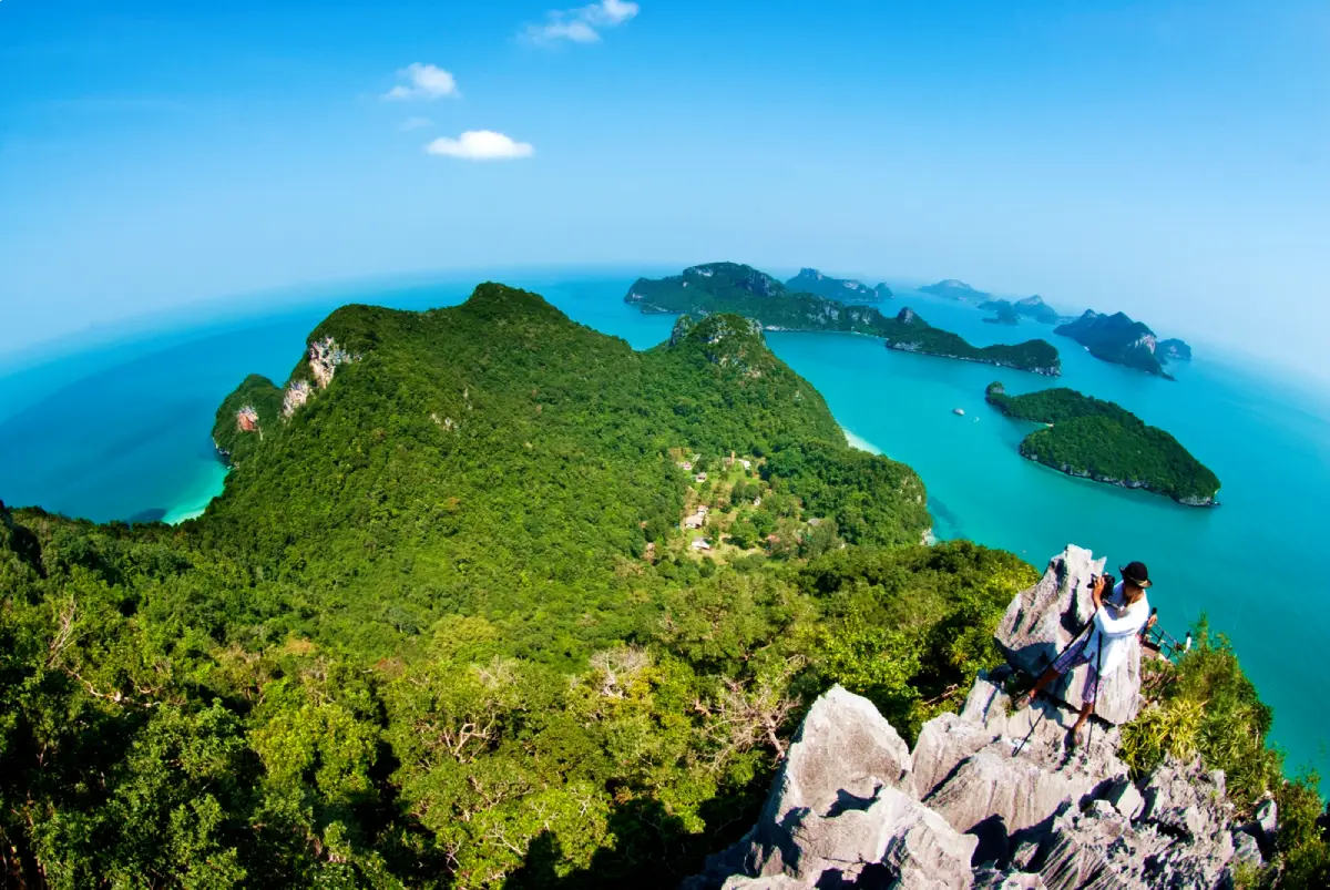
The name Ang Thong can be understood as a “golden basin” or a sheltered bowl-like seascape surrounded by islands. From the high viewpoints, the archipelago appears as a chain of green limestone islands scattered across blue water. This distinctive panorama has become one of the signature images of Surat Thani tourism. For many visitors, the main reason to come here is to see the islands from above, especially from the viewpoint on Ko Wua Ta Lap, where the landscape opens into a wide view of the Gulf of Thailand.
Ko Wua Ta Lap is the main visitor hub of Mu Ko Ang Thong National Park. The island is home to the park headquarters, visitor center, ranger station, welfare shop, restaurant, bungalows, camping area, restrooms, and a white sandy beach in front of the park office. This is the island where most day tours stop because it offers the widest range of activities in one place. Visitors can swim near the beach, relax under the trees, rent or join kayaking activities, walk to Bua Bok Cave, or climb to the famous Pha Chan Charat viewpoint.
The Pha Chan Charat viewpoint on Ko Wua Ta Lap is one of the most memorable highlights of the park. The trail from the visitor area is about 500 meters long, but it is steep and physically demanding. Ropes and stopping points are available along parts of the route, yet visitors should wear proper shoes, carry drinking water, and allow enough time for both the climb and descent. At the top, the view opens over the limestone islands, turquoise bays, and deep blue sea. It is one of the best elevated viewpoints in the Gulf of Thailand because it shows the structure of the entire archipelago rather than only a single beach.
Bua Bok Cave is another interesting site on Ko Wua Ta Lap. The cave is known for stalagmites and stalactites, including formations that resemble blooming lotus flowers. It can be reached by a trail of about 1 kilometer from the park headquarters area. The cave adds a geological dimension to the trip and helps visitors understand why Ang Thong is more than a beach destination. The path can be slippery in places, and the cave interior may have limited light, so visitors should move carefully and consider their fitness level and tour schedule before adding this walk to a day-trip itinerary.
Thale Nai on Ko Mae Ko is the second major landmark of the park. It is an emerald saltwater lagoon enclosed by limestone cliffs and forest. The lagoon was formed by limestone collapse and is connected to the surrounding sea through natural openings and underwater channels. From the viewpoint, visitors see a calm green body of water framed by steep rock walls, creating a strong contrast with the open sea outside the island. The walking route to the viewpoint includes stairs and steep sections, but the reward is one of the most distinctive views in the entire archipelago.
Ko Sam Sao lies near Ko Mae Ko and is known for beaches, coral areas, and a natural stone arch that curves out toward the sea. The island is attractive for visitors who enjoy quiet coastal scenery, snorkeling in suitable conditions, and unusual limestone shapes. Some camping activity has historically been allowed in designated areas, but anyone planning to stay overnight or use remote areas should contact the park in advance and prepare food, drinking water, and essential supplies. Facilities outside Ko Wua Ta Lap are limited.
Other notable areas include Ko Thai Plao, Ko Wua Kan Tang, and Ko Hin Dap. Ko Thai Plao and Ko Wua Kan Tang are known for coral and marine scenery, while Ko Hin Dap is recognized for a long sandy beach and layered rock formations that look like natural sculpture. These places show the variety of the national park: some islands are best for viewpoints, some for kayaking, some for snorkeling, and others for beaches or rock formations. Because not every tour stops at the same islands, travelers should read the itinerary carefully before booking.
Main activities in Mu Ko Ang Thong National Park include sightseeing by boat, kayaking along limestone cliffs, snorkeling in permitted areas, hiking to viewpoints, swimming near designated beaches, exploring caves, and relaxing on Ko Wua Ta Lap. Kayaking is best done through a tour that provides equipment and staff supervision. Snorkeling conditions can vary depending on season, weather, waves, and water visibility. The Gulf of Thailand can be calm and clear on one day and sedimented or choppy on another, so the best trip is one that allows some flexibility and follows local safety advice.
The most suitable time to visit is outside the monsoon closure period, especially when the sea is calm and the sky is clear. The park closes annually for tourism and overnight stays from 1 November to 15 December. This closure supports visitor safety and gives natural resources time to recover. Even during the open season, boat schedules can change if waves, wind, or storms make travel unsafe. Travelers should check the latest announcement, confirm the tour schedule before departure, and avoid assuming that a boat trip will operate in rough sea conditions.
Getting There usually begins from Ko Samui. Travelers first reach Ko Samui by flight, ferry from Don Sak Pier, or combined bus-and-boat services from Surat Thani. From Ko Samui, visitors join a licensed boat tour departing from Nathon Pier, Bophut, or another pier used by the tour operator. The journey to the park usually takes about 1 to 2 hours, depending on boat type and sea conditions. Speedboats are faster, while larger tour boats may feel more stable and spacious. Some tours include hotel transfers, lunch, life jackets, snorkeling equipment, and kayaking, but the national park entrance fee may be charged separately, so travelers should confirm what is included before paying.
Entrance fees are 40 baht for Thai adults and 20 baht for Thai children. For foreign visitors, the fee is 300 baht for adults and 150 baht for children. These fees are national park fees and may not be included in the tour price. Visitors planning to stay overnight on Ko Wua Ta Lap can use the park bungalows or camping area in the designated zone, subject to availability and park booking procedures. Overnight stays are especially suitable for travelers who want to experience the island after the day-trip crowds leave, when the beach becomes quieter and the atmosphere feels more remote.
Facilities are concentrated on Ko Wua Ta Lap. These include the visitor center, ranger station, restaurant, welfare shop, restrooms, bungalows, and a camping area. Other islands have fewer facilities, so visitors should carry drinking water, personal medication, waterproof bags, reef-safe sun protection, and cash for small expenses. As a protected marine national park, Ang Thong requires responsible travel behavior. Visitors should not feed wildlife, remove shells or coral, step on reefs, leave trash, disturb animals, or ignore ranger instructions. These rules protect the fragile environment that makes the park worth visiting.
The park also has ecological and geological value. The limestone islands support dry evergreen forest, limestone vegetation, coastal plants, birds, reptiles, small mammals, and marine life. The relationship between cliffs, lagoons, beaches, coral areas, and open sea creates a compact but diverse ecosystem. This is why the annual closure and visitor management measures are important. They are not just administrative rules; they help protect the natural resources that sustain tourism in the long term.
For photography, Mu Ko Ang Thong offers strong images throughout the day. Morning light works well for boat views and sea colors, mid-morning to early afternoon is suitable for the Ko Wua Ta Lap viewpoint and Thale Nai, and late afternoon gives softer light on limestone cliffs and beaches. Travelers who want viewpoint photos should allow enough time for climbing rather than rushing. Those using cameras or phones during kayaking or boat transfers should use waterproof protection and secure straps, because waves and boat movement can easily damage equipment.
Mu Ko Ang Thong National Park is suitable for families, couples, groups of friends, nature travelers, photographers, and visitors who want a scenic break from Ko Samui or Ko Pha Ngan. A one-day trip can cover the main highlights, while an overnight stay on Ko Wua Ta Lap gives a slower and quieter experience. The best itinerary depends on personal travel style. For a first visit, prioritize Ko Wua Ta Lap, the viewpoint, Thale Nai on Ko Mae Ko, and one boat or kayaking activity. With careful planning, Ang Thong becomes one of the most rewarding marine national park experiences in the Gulf of Thailand.
| Name | Mu Ko Ang Thong National Park |
| Location | Ang Thong Subdistrict, Ko Samui District, Surat Thani Province |
| Contact Address | 145/1 Talat Lang Road, Talat Subdistrict, Mueang Surat Thani District, Surat Thani 84000, Thailand |
| Coordinates | 9.6338836, 99.6692093 |
| Highlights | 42 limestone islands, Ko Wua Ta Lap viewpoint, Thale Nai Lagoon on Ko Mae Ko, Bua Bok Cave, white beaches, kayaking, snorkeling, and nature trails |
| History | Declared a national park on 12 November 1980 and recognized as an important marine national park in the Gulf of Thailand |
| Name Origin | Ang Thong can be understood as a golden basin-like seascape formed by islands surrounding the Gulf waters |
| Distinctive Features | Limestone island landscape with cliffs, caves, sinkholes, beaches, shallow coral areas, and an enclosed saltwater lagoon |
| Travel Information | Travel first to Ko Samui, then take a licensed tour boat from Nathon Pier, Bophut, or another tour-designated pier. Boat travel usually takes about 1 to 2 hours depending on boat type and sea conditions |
| Current Status | Open during the normal travel season and closed annually for tourism and overnight stays from 1 November to 15 December |
| Open Days | Daily, except for the annual closure from 1 November to 15 December |
| Opening Hours | 08.00 – 17.00 |
| Fees | Thai Adults 40 Baht, Thai Children 20 Baht / Foreign Adults 300 Baht, Foreign Children 150 Baht |
| Facilities | Visitor center, ranger station, restaurant, welfare shop, restrooms, bungalows, camping area, and beach facilities on Ko Wua Ta Lap |
| Main Areas / Zones | Ko Wua Ta Lap, Pha Chan Charat Viewpoint, Bua Bok Cave, Ko Mae Ko, Thale Nai Lagoon, Ko Sam Sao, Ko Thai Plao, Ko Wua Kan Tang, Ko Hin Dap, Ko Phaluai |
| Main Contact Number | 064-642-5186, 077-286-025, 077-280-222, 077-286-588, 061-285-7364 |
| Official Website / Official Page | Facebook: อุทยานแห่งชาติหมู่เกาะอ่างทอง - Mu Ko Ang Thong National park / Department of National Parks, Wildlife and Plant Conservation website |
| Nearby Tourist Attractions | 1. Pha Chan Charat Viewpoint, Ko Wua Ta Lap, about 0.5 km walking distance 2. Bua Bok Cave, Ko Wua Ta Lap, about 1 km walking distance 3. Thale Nai Lagoon, Ko Mae Ko, about 15 minutes by boat from Ko Wua Ta Lap 4. Ko Sam Sao, opposite Ko Mae Ko 5. Ko Hin Dap, within Mu Ko Ang Thong National Park |
| Nearby Restaurants | 1. National Park Welfare Restaurant, Ko Wua Ta Lap, inside the park 2. Aromi Pierside Italian Pizzeria Restaurant Coffee and Bar, near Nathon Pier, about 30 km by sea, Tel. 096-679-9596 3. Lucky Restaurant, Nathon, Ko Samui, about 30 km by sea, Tel. 084-855-3844 4. Krua Savoey Samui, Nathon, Ko Samui, about 30 km by sea, Tel. 077-420-380 5. King of Bread Nathon, Ko Samui, about 30 km by sea, Tel. 084-184-2541 6. El Barril, Nathon, Ko Samui, about 30 km by sea, Tel. 084-842-0181 |
| Nearby Accommodations | 1. National Park Bungalows, Ko Wua Ta Lap, inside the park, Tel. 077-286-588, 061-285-7364 2. Stay Inn Samui, Nathon, Ko Samui, about 30 km by sea, Tel. 077-953-153 3. Nathon Residence Hotel, Nathon, Ko Samui, about 30 km by sea, Tel. 077-332-662 4. My Living Place Nathon, Nathon, Ko Samui, about 30 km by sea, Tel. 093-574-3944 5. Sea Valley Resort, Lipa Noi, Ko Samui, about 36 km by sea and road, Tel. 077-485-745 6. Four Seasons Resort Koh Samui, Ang Thong, Ko Samui, about 30 km by sea and road, Tel. 077-243-000 |
Frequently Asked Questions (FAQ)
Q: Where is Mu Ko Ang Thong National Park located?
A: Mu Ko Ang Thong National Park is located in Ang Thong Subdistrict, Ko Samui District, Surat Thani Province, west of Ko Samui in the Gulf of Thailand.
Q: When is Mu Ko Ang Thong National Park open?
A: The park is generally open daily from 08.00 to 17.00, except for the annual tourism and overnight closure from 1 November to 15 December.
Q: How much is the entrance fee?
A: Thai visitors pay 40 baht for adults and 20 baht for children. Foreign visitors pay 300 baht for adults and 150 baht for children. The park fee may not be included in the tour price.
Q: What are the main highlights of Mu Ko Ang Thong National Park?
A: The main highlights are the Ko Wua Ta Lap viewpoint, Thale Nai Lagoon on Ko Mae Ko, Bua Bok Cave, white beaches, limestone islands, kayaking, and snorkeling activities.
Q: How do travelers get to Mu Ko Ang Thong National Park?
A: Most travelers first go to Ko Samui, then take a licensed tour boat from Nathon Pier, Bophut, or another tour-designated pier. The boat trip usually takes about 1 to 2 hours.
Q: Can visitors stay overnight in the national park?
A: Yes. Overnight stays are available in the designated area on Ko Wua Ta Lap, where the park provides limited bungalows and a camping area. Advance contact with the park is recommended.
Q: Is the park suitable for children and older travelers?
A: Boat sightseeing and beach time can suit many visitors, but the viewpoint trails and the route to Thale Nai include steep sections. Children, older travelers, and people with knee problems should choose activities carefully.
Q: What should visitors prepare before visiting?
A: Visitors should book a licensed tour in advance, check the weather, bring proper walking shoes, a hat, reef-safe sunscreen, a waterproof bag, drinking water, personal medication, and some cash for small expenses.
 Category: ●Nature and Wildlife
 Group: ●National Parks and Marine Reserves
Last Update : 2 MonthAgo
 Last Update : 2 MonthAgo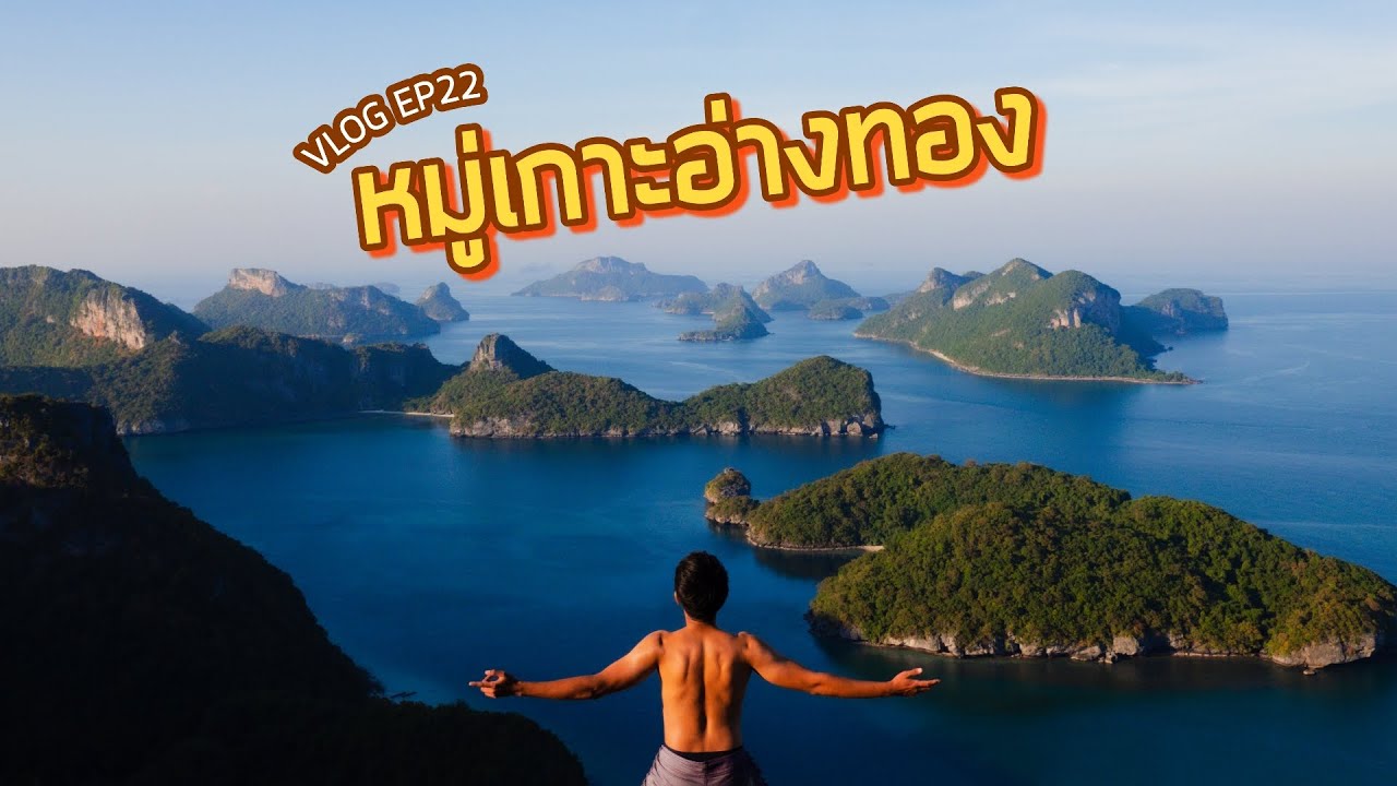
 Click to Access the Navigation Map GPS
Mu Ko Ang Thong National Park Map
Gellery
Recommend

 Art, Culture and Heritage
 Landmarks and Memorials(1)
 Art, Craft Centres, Tradition(8)
 Museums(5)
 Educational Places
 Educational Gardens, Farm(1)
 Places of Worship
 Temple(32)
 Other Sacred Sites(8)
 Research and Development
 Royal Project(1)
 Suburban Living
 Village, Community(6)
 Local Market(1)
National Parks and Marine Reserves(8)
Local Market(1)
National Parks and Marine Reserves(8)
 Mountain (Doi)(2)
 Dam, Reservoir, Lake(8)
 Waterfalls(34)
 Hot Springs(7)
 Caves(18)
 River, Canal(11)
 Bays and Beaches(30)
 Islands(16)
 Other natural attractions(10)
 Entertainment and Agricultural
 Animal camps and shows(6)
 Farms, Parks and Ecotourism(7)
 Outdoor and Adventure Activities(2)
 Shopping
 Shopping and Night Market(1)
 Travel Articles, Recipes
 Travel Review, Food Review(1)
 Southern Food Menu, Southern Food Recipes(1)


