
lovethailand home >South Travel Attractions >Chumphon Travel Attractions >Muang Chumphon >Na Thung > Khlong Hua Wang-Phanang Tak
TL;DR: Khlong Hua Wang-Phanang Tak is located at Bang Luek and Na Thung Subdistricts, Mueang Chumphon District, Chumphon Province, open Daily, hours General outdoor visit is best from 06.00 – 18.00 / Study visits should be.
Khlong Hua Wang-Phanang Tak
Open Days: Daily
Opening Hours: General outdoor visit is best from 06.00 – 18.00 / Study visits should be arranged in advance
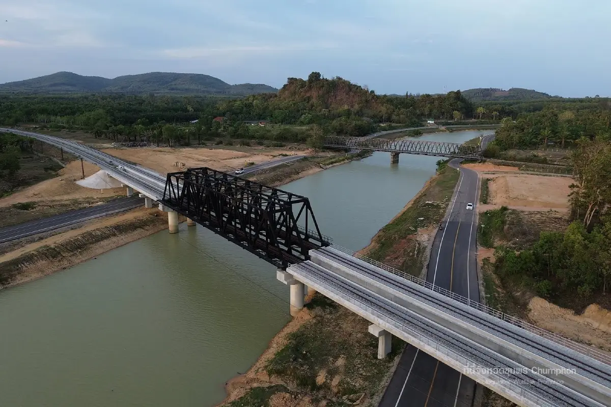
Khlong Hua Wang-Phanang Tak, widely known by local people as Khlong Nai Luang, is one of Chumphon’s most important water-management landmarks. Built by the Royal Irrigation Department, the canal was designed to drain water from the Tha Taphao River near Ban Hua Wang in Bang Luek Subdistrict, Mueang Chumphon District, to the sea at Phanang Tak Bay in Na Thung Subdistrict. The canal is about 8,100 meters long and works together with the Nong Yai natural monkey-cheek reservoir, which serves as a flood-retention area, emergency water-storage basin, agricultural water reserve, and public learning site for Chumphon Province.
The importance of Khlong Hua Wang-Phanang Tak goes far beyond the image of an ordinary canal. It is part of a wider flood-mitigation system designed to help move excess water from the lower areas of Chumphon city to the sea more efficiently. Chumphon receives water from mountain and watershed areas before it flows down toward urban and agricultural zones. During heavy rain, water levels in major waterways can rise quickly. This canal provides an additional drainage route, reducing pressure on the city and helping the Nong Yai monkey-cheek system function more effectively.
The local name Khlong Nai Luang reflects the deep connection between the people of Chumphon and the royal water-management initiative. The canal is associated with the royal initiative of King Bhumibol Adulyadej the Great to solve Chumphon’s recurring flood problems after the severe floods of 1997. The main idea was to create a drainage route that could release floodwater to the sea in time while using Nong Yai as a natural retention area. Because local people directly benefited from the project, the canal became remembered with respect as Khlong Nai Luang, or the King’s Canal.
In irrigation terms, Khlong Hua Wang-Phanang Tak acts as a major floodway for Mueang Chumphon. It receives water near Ban Hua Wang in Bang Luek Subdistrict and carries it toward Phanang Tak Bay in Na Thung Subdistrict. This helps reduce the time that floodwater remains in low-lying urban areas, as excess water is not forced to rely only on older natural waterways. When combined with Nong Yai, the system works as a retention basin, diversion route, and drainage network in one connected landscape.
Nong Yai is the heart of the system. It functions as Chumphon’s natural monkey-cheek reservoir. The monkey-cheek concept means holding excess water temporarily in a suitable area before gradually draining it away. When floodwater enters the city area in large volume, Nong Yai can hold part of that water and release it through Khlong Hua Wang-Phanang Tak and related canals toward the sea. This reduces flood severity, protects homes and farmland, and helps safeguard important transport and economic areas of Chumphon.
Beyond flood prevention, the Nong Yai Royal Development Project also plays an important role in water storage during dry periods. A large retention area like this helps provide water security for surrounding communities and agricultural areas. The project therefore addresses both flood-season risk and dry-season water demand. It is not only an emergency response system but also a long-term water infrastructure for Chumphon.
For visitors, Khlong Hua Wang-Phanang Tak and Nong Yai are more than hydraulic infrastructure. The area has become a public nature and learning destination with a wide water body, green surroundings, agricultural learning plots, Mai Khiam Bridge, the deer-viewing bridge, walking areas, photo spots, and learning zones related to water management and the Sufficiency Economy philosophy. Visitors can walk, take photos, enjoy the scenery, feed fish in designated areas, watch birds and deer, and learn how a royal water-management concept works in a real city landscape.
Mai Khiam Bridge is one of the most recognizable highlights of Nong Yai. The wooden bridge curves across the reservoir in a quiet natural setting. It is a good place for walking, photography, and sunset views. Mai Khiam is a strong hardwood found in Southern Thailand and known for its durability in wet environments. The bridge combines local material, simple design, and waterside scenery, making it one of the most photogenic public spaces in Chumphon.
The deer-viewing bridge is another popular point, especially for families. It allows visitors to walk across an open natural area and see deer in a calm setting. The best times are early morning and late afternoon, when the heat is lower and the light is softer. Visitors should behave respectfully, avoid loud noise, feed animals only in appropriate ways, and keep the area clean. This part of Nong Yai is suitable for light nature walks rather than rushed sightseeing.
The Nong Yai project area also includes learning zones related to agriculture and the Sufficiency Economy approach. These may include vegetable plots, herbs, rice demonstration areas, water-use learning, animal husbandry, and livelihood knowledge for local communities. This makes the site more than a scenic stop. It shows how water management connects directly with agriculture, disaster prevention, and community self-reliance.
The natural landscape of Nong Yai is also a habitat for birds and other wildlife. It is suitable for visitors who enjoy slow walking, casual nature photography, and quiet outdoor spaces. The wide water surface creates a cooling visual effect, while trees and walking paths offer a relaxed public-park atmosphere. Mornings are peaceful, while evenings are suitable for reflections on the water and soft light over the bridge.
A visit to Khlong Hua Wang-Phanang Tak should be understood as a visit to a complete water system rather than a single canal. The larger landscape includes the drainage canal, Nong Yai retention area, Sam Kaeo Canal, Lamu Canal, water-control structures, and public learning spaces. Understanding this whole system allows visitors to appreciate not only the beauty of the water and bridges but also the careful thinking behind flood prevention and urban resilience.
The canal is distinctive because of its relationship with Chumphon’s major floods and its role in reducing disaster damage. In the past, the province faced severe flooding caused by heavy rain and storms. The canal and Nong Yai monkey-cheek area gave the city a more structured way to manage excess water. Floodwater could be held, diverted, and released in stages, reducing the impact on homes, farms, roads, and economic zones.
In terms of access, Nong Yai is located in Bang Luek Subdistrict, Mueang Chumphon District, not far from Chumphon town. Visitors can travel by private vehicle using local roads toward the Nong Yai Royal Development Project, Mai Khiam Bridge, or the deer-viewing bridge. The area is mostly outdoors, so hats, umbrellas, drinking water, and comfortable shoes are recommended. Morning and late afternoon visits are more comfortable than midday visits.
Getting There from Chumphon town is straightforward and suitable for a half-day trip. Visitors can start at the Nong Yai Royal Development Project, walk along Mai Khiam Bridge, continue to the deer-viewing bridge, and spend time by the water. Study groups that require a guided lecture should arrange the visit in advance because educational visits differ from casual sightseeing and may involve a group fee for a speaker.
Khlong Hua Wang-Phanang Tak suits several types of visitors. Those interested in royal development projects and water management can learn from a real flood-mitigation system. Families can enjoy an outdoor space close to town. Photographers can capture bridges, water reflections, wildlife, and evening light. Study groups can connect the site with lessons on water, agriculture, the Sufficiency Economy, and community-based public space management.
Visitors should keep the area clean, avoid throwing rubbish into the water, avoid climbing bridge railings, avoid entering water areas not designated for recreation, and supervise children closely. Since the site contains wide water surfaces and several bridges, basic safety is important. After rain, wooden paths and outdoor walkways may become slippery. Early morning and late afternoon are the most comfortable times for walking.
For a fuller Chumphon route, visitors can combine Nong Yai with Mai Khiam Bridge, the deer-viewing bridge, Chumphon National Museum, Wat Sam Kaeo, Sairee Beach, and Khao Matsee Viewpoint. This creates a one-day route that includes water management, nature, local history, religious sites, coastal scenery, and city viewpoints.
Khlong Hua Wang-Phanang Tak is therefore more than a canal. It tells the story of water, city life, community safety, and royal development in one place. Standing by Nong Yai or walking on the wooden bridge, visitors see not only a beautiful public landscape but also the result of a water-management concept designed to protect people, support agriculture, and improve the quality of life in Chumphon.
| Name | Khlong Hua Wang-Phanang Tak / Khlong Nai Luang |
| Location | Bang Luek and Na Thung Subdistricts, Mueang Chumphon District, Chumphon Province |
| Main Visitor Area | Nong Yai Royal Development Project, Bang Luek Subdistrict, Mueang Chumphon District, Chumphon Province |
| Navigation Point | Search for “Nong Yai Royal Development Project”, “Mai Khiam Bridge Nong Yai”, or “Deer-Viewing Bridge Nong Yai Chumphon” |
| Canal Length | About 8,100 meters |
| Water Route | From the Tha Taphao River near Ban Hua Wang, Bang Luek Subdistrict, to Phanang Tak Bay, Na Thung Subdistrict, Mueang Chumphon District |
| Importance | A royal flood-mitigation canal and natural monkey-cheek water-retention system for Chumphon city |
| Related Authorities | Royal Irrigation Department, Office of the Royal Development Projects Board, Chumphon Province, and local authorities |
| Current Status | A floodway, natural monkey-cheek reservoir, water reserve, public learning site, and local recreation area in Chumphon |
| Open Days | Daily |
| Opening Hours | General outdoor visit is best from 06.00 – 18.00 / Study visits should be arranged in advance |
| Fees | No admission fee for general walking areas |
| Study Visit Fee | Guided lecture service is 2,000 baht per group and must be arranged in advance |
| Main Areas / Zones | Khlong Hua Wang-Phanang Tak, Nong Yai monkey-cheek area, Mai Khiam Bridge, deer-viewing bridge, natural forest zone, agricultural learning area, demonstration plots, and waterfront walking areas |
| Facilities | Parking area, walking paths, wooden bridge, resting areas, photo spots, and water-management and Sufficiency Economy learning zones |
| Best Time to Visit | Morning and late afternoon, especially for walking, photography, water reflections, and bridge scenery |
| Visitor Precautions | Do not litter, do not climb bridge railings, do not enter undesignated water areas, supervise children closely, and be careful on slippery paths after rain |
| Nearby Tourist Attractions | 1. Mai Khiam Bridge Nong Yai, about 0.2 km 2. Deer-Viewing Bridge Nong Yai, about 0.7 km 3. Chumphon National Museum, about 3 km 4. Wat Sam Kaeo, about 4 km 5. Khao Matsee Viewpoint, about 18 km |
| Nearby Restaurants | 1. Melani Restaurant and Internet at Bang Luek, about 3 km, Tel. 077-631-243 2. Khrua Dara, about 4 km, Tel. 095-029-5552 3. Sak Khun Nai Noi, about 4 km, Tel. 094-805-7827 4. Kor Gift Kin Keng, about 4 km, Tel. 093-760-1258, 091-071-8347 5. Khrua Chang Kon, about 5 km, Tel. 095-263-9179, 093-620-6746 |
| Nearby Accommodations | 1. Euro Boutique Hotel, about 6 km, Tel. 077-502-300 2. A-Te Chumphon Hotel, about 7 km, Tel. 077-503-222, 088-758-0358 3. Morakot Chumphon Hotel, about 7 km, Tel. 077-503-630 4. Nana Buri Hotel, about 7 km, Tel. 077-970-079 5. Chumphon Travelodge, about 5 km |
Frequently Asked Questions (FAQ)
Q: Where is Khlong Hua Wang-Phanang Tak located?
A: Khlong Hua Wang-Phanang Tak is located in Mueang Chumphon District, Chumphon Province. It carries water from the Tha Taphao River near Ban Hua Wang in Bang Luek Subdistrict to Phanang Tak Bay in Na Thung Subdistrict.
Q: Why is it called Khlong Nai Luang?
A: The canal is connected with King Bhumibol Adulyadej the Great’s royal initiative to solve Chumphon’s flood problems, so local people remember it respectfully as Khlong Nai Luang, or the King’s Canal.
Q: How long is Khlong Hua Wang-Phanang Tak?
A: The canal is about 8,100 meters long and functions as an important drainage route from Chumphon city toward the sea.
Q: How is Nong Yai related to the canal?
A: Nong Yai functions as a natural monkey-cheek reservoir. It temporarily stores excess water and gradually releases it through Khlong Hua Wang-Phanang Tak and related canals to the sea.
Q: Can visitors travel to Khlong Hua Wang-Phanang Tak?
A: Yes. The main visitor area is the Nong Yai Royal Development Project, where visitors can walk around Mai Khiam Bridge, the deer-viewing bridge, water areas, and learning zones.
Q: Is there an entrance fee?
A: General walking areas have no admission fee. Study visits with a guided lecture should be arranged in advance and may involve a group speaker fee.
Q: What is the best time to visit?
A: Morning and late afternoon are the most suitable times because the weather is cooler and the light is better for walking and photography.
Q: What nearby places can be combined with the visit?
A: Nearby places include Mai Khiam Bridge, the deer-viewing bridge, Chumphon National Museum, Wat Sam Kaeo, Sairee Beach, and Khao Matsee Viewpoint.
 Category: ●Nature and Wildlife
 Group: ●Dam, Reservoir, Lake
Last Update : 2 MonthAgo
 Last Update : 2 MonthAgo
 Click to Access the Navigation Map GPS
Khlong Hua Wang-Phanang Tak Map
Recommend

 Art, Culture and Heritage
 Historical Sites and Monuments(1)
 Landmarks and Memorials(2)
 Art, Craft Centres, Tradition(3)
 Museums(2)
 Educational Places
 Educational Gardens, Farm(1)
 Places of Worship
 Temple(31)
 Other Sacred Sites(10)
 Research and Development
 Royal Project(1)
 Suburban Living
 Village, Community(5)
 Local Market(1)
 National Parks and Marine Reserves(7)
 Mountain (Doi)(5)
Dam, Reservoir, Lake(1)
 Waterfalls(26)
 Hot Springs(1)
 Caves(21)
 River, Canal(7)
 Bays and Beaches(30)
 Islands(13)
 Other natural attractions(7)
 Entertainment and Agricultural
 Farms, Parks and Ecotourism(3)
 Outdoor and Adventure Activities(4)
 Shopping
 Shopping and Night Market(1)
 Travel Articles, Recipes
 Travel Review, Food Review(1)


