
lovethailand home >South Travel Attractions >Chumphon Travel Attractions >Muang Chumphon >Bang Luek > Nong Yai Royal Development Project
TL;DR: Nong Yai Royal Development Project is located at Bang Luek Subdistrict, Mueang Chumphon District, Chumphon Province, open Daily, hours 08.00 - 16.30.
Nong Yai Royal Development Project
Open Days: Daily
Opening Hours: 08.00 - 16.30
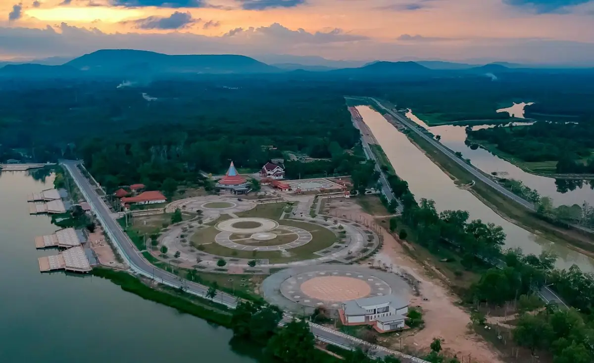
Nong Yai Royal Development Project, widely known as Kaem Ling Nong Yai, is one of Chumphon’s most important royal-initiated water management and learning sites. Located in Bang Luek Subdistrict, Mueang Chumphon District, the project covers about 3,000 rai and functions as a natural flood-retention area, reservoir, ecological wetland, birdwatching site, and Sufficiency Economy learning center. The area features a large reservoir, shaded trees around the water, wetland habitats, nature trails, Saphan Mai Khiam wooden bridge, birdwatching areas, agricultural learning plots, and Ko Lek 9, making it a meaningful destination for travelers who want to understand Chumphon beyond beaches and islands.
Nong Yai Royal Development Project should be understood as more than a public park or photo spot. It is a practical water-management solution created to address Chumphon’s repeated flooding problems. Chumphon receives water from upper catchment areas through streams and canals before the water moves toward the sea. During heavy rain or flood periods, large volumes of water can quickly reach urban areas. Nong Yai was developed to act as a natural “monkey cheek,” storing excess water temporarily and gradually releasing it through the Hua Wang-Phanang Tak drainage canal system toward the sea.
The “monkey cheek” concept is easy to understand but powerful. It compares water retention to a monkey holding food in its cheek before slowly swallowing it. In Chumphon, Nong Yai receives floodwater, holds it, and then releases it in a controlled manner. This helps reduce the immediate burden on the city’s drainage system, protects nearby communities and farmland, and also allows water to be stored for use during the dry season.
The royal initiative behind Nong Yai focused on integrated flood management. It involved improving water-control structures, establishing water-level monitoring and warning systems, linking relevant canals, draining excess water through Hua Wang-Phanang Tak, and installing pumps at key water-control gates. The project therefore represents a complete water-management system, connecting upstream conditions, retention areas, drainage routes, and downstream discharge to the sea.
The Hua Wang-Phanang Tak drainage canal is central to the story of Nong Yai. During the period when Typhoon Linda was approaching, canal excavation work was accelerated so that the drainage route could be completed in time. This helped improve Chumphon’s ability to move excess water out of the flood-prone area. For local people, this story is part of the project’s meaning because it shows how royal initiative, engineering work, and community cooperation came together to reduce flood risk.
The project covers about 3,000 rai and includes a large reservoir, wetland edges, perennial trees, natural areas, agricultural learning spaces, and facilities for public education. The overall atmosphere is quiet, open, and green. The broad water surface, shade trees, and wetland vegetation make the site suitable for walking, relaxing, photography, studying water management, and observing wetland ecology.
Ecologically, Nong Yai is valuable as a wetland habitat in Mueang Chumphon District. The reservoir edge supports aquatic plants, waterside vegetation, open wetland zones, and bird habitat. Visitors interested in birdwatching can use the area to observe how water, plants, and birds interact in a wetland ecosystem. Morning and late afternoon are the best times for bird observation because the light is softer, the weather is cooler, and birds are more active.
One of the most popular highlights is Saphan Mai Khiam, the wooden bridge that crosses the water within the project area. It gives visitors a clear view of the reservoir, the surrounding trees, and the calm landscape. Khiam is a durable hardwood associated with southern Thailand, making the bridge visually and culturally suitable for the setting. Visitors should walk carefully, avoid running, and share the bridge respectfully with families, elderly visitors, and other travelers.
The project can be understood through several functional zones. The first is the natural forest and wetland area, which supports birds and other wildlife. The second is the agricultural learning area, where visitors can see examples of Sufficiency Economy practice such as vegetables, herbs, rice plots, animal raising, and community-based livelihood activities. The third is Ko Lek 9 and the learning center area, which serve as important educational points. Together, these zones show that Nong Yai is not only a tourist destination but also a public learning space for water, agriculture, ecology, and community resilience.
For families, Nong Yai is a useful place to teach children about water management and nature. Children can see how a reservoir stores water, why drainage canals matter, how wetlands support birds, and why trees around the water are important. Seeing these elements in real life makes environmental learning more concrete than reading about it in a classroom.
For visitors interested in the Sufficiency Economy philosophy, Nong Yai provides practical examples of how land, water, agriculture, and community knowledge can be combined. The project functions as a learning site for schools, universities, farmer groups, public agencies, and visitors who want to understand how royal development concepts can be applied to real local conditions.
Getting There from Chumphon town is straightforward by private car, rental car, or local hired transport. Follow the Chumphon-Ao Thung Wua Laen route. When reaching the Chumphon Irrigation area, turn right and continue along the Hua Wang-Phanang Tak canal road toward the project office. Another practical route is to travel via the Chumphon Government Complex and Chumphon National Museum, then continue into Bang Luek Subdistrict.
Nong Yai is close enough to Chumphon town for a half-day visit. In the morning, visitors can walk around the reservoir, visit the wooden bridge, observe birds, and explore the learning areas. After that, nearby attractions such as Chumphon National Museum, Wat Sam Kaew, Wat Na Thung, and the Youth Soldier Monument can be added to the same route. In the late afternoon, visitors can continue toward Thung Wua Laen Beach or Khao Matsee Viewpoint if they want to combine inland ecology with coastal scenery.
The best time to visit is early morning or late afternoon. The weather is cooler, the light is better for photography, and the wetland atmosphere is more comfortable. Midday visits are still possible, but visitors should bring drinking water, a hat, and comfortable walking shoes. Birdwatchers should keep quiet, maintain distance from birds, avoid throwing food, and avoid disturbing waterside areas.
Groups that want a formal study visit with a speaker should contact the project in advance. Guided lectures are useful for schools, government agencies, farmer groups, and organizations that want to understand the water-management system and Sufficiency Economy learning areas in a structured way. Preparing questions in advance will make the visit more useful, especially on topics such as flood retention, canal systems, community agriculture, and environmental education.
Visitors should keep the project clean, avoid throwing waste into the water, avoid collecting plants or disturbing animals, avoid feeding wildlife in unauthorized areas, and drive slowly within the project area. Nong Yai is a learning center and ecological space, not an amusement area. Respectful travel helps protect the wetland, the reservoir, and the public learning value of the project.
The strength of Nong Yai is that every part of the landscape has a purpose. The reservoir supports water retention. Trees create shade and stabilize the environment. The wetland supports birds and biodiversity. Agricultural plots demonstrate livelihood learning. Walking routes allow the public to access knowledge in the middle of nature. A visit here is therefore not only about taking photos of the bridge or water, but about understanding how good water management can protect a city, support communities, and preserve nature at the same time.
Overall, Nong Yai Royal Development Project is one of the best places to understand Chumphon beyond beaches, islands, and seafood. It shows how a flood-prone area can become a living landscape for water management, environmental education, agriculture, and public recreation. For travelers who want deeper insight into the province, Nong Yai is a highly meaningful stop in Mueang Chumphon.
| Name | Nong Yai Royal Development Project / Kaem Ling Nong Yai / Nong Yai Royal Initiative Project |
| Location | Bang Luek Subdistrict, Mueang Chumphon District, Chumphon Province |
| Address | Bang Luek Subdistrict, Mueang Chumphon District, Chumphon 86000, Thailand |
| Highlights | Royal-initiated flood-retention area, large reservoir, Saphan Mai Khiam wooden bridge, wetland ecosystem, birdwatching area, nature trail, agricultural learning plots, and Ko Lek 9 learning zone |
| Distinctive Features | A water-management project that reduces Chumphon’s flood risk while functioning as an ecological, agricultural, and Sufficiency Economy learning center |
| Project Area | About 3,000 rai, including reservoir, wetland, natural area, agricultural learning area, and public learning zones |
| Name Origin | The “monkey cheek” name comes from the royal water-management concept of holding floodwater temporarily in Nong Yai before gradually releasing it toward the sea through Hua Wang-Phanang Tak Canal |
| Travel Information | From Chumphon town, follow the Chumphon-Ao Thung Wua Laen route. At the Chumphon Irrigation area, turn right and continue along Hua Wang-Phanang Tak Canal to the project office. Another route passes the Chumphon Government Complex and Chumphon National Museum into Bang Luek Subdistrict. |
| Current Status | Open as a learning center, public recreation area, and ecological attraction in Mueang Chumphon District |
| Open Days | Daily |
| Opening Hours | 08.00 - 16.30 |
| Guided Lecture Service | Group study visits can arrange a lecturer in advance. The lecture fee is 2,000 baht per group. |
| Main Areas / Zones | 1. Nong Yai Reservoir 2. Natural Forest And Wetland Area 3. Saphan Mai Khiam And Nature Walking Route 4. Birdwatching And Plant-Observation Island 5. Agricultural And Sufficiency Economy Learning Area 6. Ko Lek 9 And Learning Center Area 7. Hua Wang-Phanang Tak Canal Route |
| Facilities | Parking Area, Nature Walking Routes, Reservoir Rest Areas, Learning Stations, Demonstration Plots, And Study-Visit Areas |
| Recommended Activities | Walking, Reservoir Viewpoints, Photography, Learning About The Monkey-Cheek Water System, Birdwatching, Wetland Ecology Study, Sufficiency Economy Learning, And Group Study Visits |
| Visitor Guidelines | Keep The Area Clean, Do Not Throw Waste Into The Water, Avoid Disturbing Birds And Wildlife, Drive Slowly, And Respect The Rules Of The Learning Center |
| Nearby Tourist Attractions | 1. Saphan Mai Khiam At Nong Yai Chumphon, About 0.22 km 2. Chumphon National Museum, About 2.52 km 3. Wat Sam Kaew, About 3.21 km 4. Wat Na Thung, About 4.67 km 5. Youth Soldier Monument, About 7.53 km 6. Thung Wua Laen Beach, About 15 km |
| Nearby Restaurants | 1. Krua Ban Tawan, About 2 km, Tel. 094-713-5758 2. Krua Dara, About 3 km, Tel. 095-029-5552 3. Krua Chang Kon, About 3 km, Tel. 095-263-9179, 093-620-6746 4. Sak Khun Nainoi, About 4 km, Tel. 094-805-7827 5. Ban Sam Ung, About 5 km, Tel. 097-131-2622 |
| Nearby Accommodations | 1. Palm Sweet Resort, About 5 km, Tel. 077-631-112, 096-653-3256 2. Chalicha Resort, About 8 km, Tel. 077-502-888 3. HOP INN Chumphon, About 8 km, Tel. 02-080-2222 4. A-Te Chumphon Hotel, About 9 km 5. Loft Mania Boutique Hotel Chumphon, About 9 km |
Frequently Asked Questions (FAQ)
Q: Where Is Nong Yai Royal Development Project Located?
A: It is located in Bang Luek Subdistrict, Mueang Chumphon District, Chumphon Province.
Q: Why Is Nong Yai Important?
A: It is a royal-initiated monkey-cheek water-retention project that helps reduce flooding in Chumphon while serving as a learning center for water management, agriculture, and wetland ecology.
Q: What Are The Opening Days And Hours?
A: The project is open daily from 08.00 to 16.30.
Q: What Are The Main Highlights Inside The Project?
A: Highlights include the large reservoir, Saphan Mai Khiam wooden bridge, wetland area, birdwatching spots, nature walking route, agricultural learning plots, and Ko Lek 9.
Q: How Do Travelers Get There?
A: From Chumphon town, take the Chumphon-Ao Thung Wua Laen route, turn right near the Chumphon Irrigation area, and follow the Hua Wang-Phanang Tak canal road to the project. Another route passes the Chumphon Government Complex and Chumphon National Museum.
Q: Is Nong Yai Suitable For Birdwatching?
A: Yes. The reservoir edge and wetland areas support various birds, especially in the morning and late afternoon.
Q: Can Groups Arrange A Guided Lecture?
A: Yes. Groups can arrange a lecturer in advance. The guided lecture fee is 2,000 baht per group.
Q: What Nearby Places Can Be Combined With A Visit?
A: Nearby places include Chumphon National Museum, Wat Sam Kaew, Wat Na Thung, Youth Soldier Monument, Thung Wua Laen Beach, and Khao Matsee Viewpoint.
 Category: ●Research and Development
 Group: ●Royal Project
Last Update : 2 MonthAgo
 Last Update : 2 MonthAgo

 Click to Access the Navigation Map GPS
Nong Yai Royal Development Project Map
Recommend

 Art, Culture and Heritage
 Historical Sites and Monuments(1)
 Landmarks and Memorials(2)
 Art, Craft Centres, Tradition(3)
 Museums(2)
 Educational Places
 Educational Gardens, Farm(1)
 Places of Worship
 Temple(31)
 Other Sacred Sites(10)
Royal Project(1)
 Suburban Living
 Village, Community(5)
 Local Market(1)
 Nature and Wildlife
 National Parks and Marine Reserves(7)
 Mountain (Doi)(5)
 Dam, Reservoir, Lake(1)
 Waterfalls(26)
 Hot Springs(1)
 Caves(21)
 River, Canal(7)
 Bays and Beaches(30)
 Islands(13)
 Other natural attractions(7)
 Entertainment and Agricultural
 Farms, Parks and Ecotourism(3)
 Outdoor and Adventure Activities(4)
 Shopping
 Shopping and Night Market(1)
 Travel Articles, Recipes
 Travel Review, Food Review(1)


