
lovethailand home >Eastern Travel Attractions >Trat Travel Attractions >Khlong Yai >Hat Lek > Narrowest Part of Thailand
TL;DR: Narrowest Part of Thailand is located at Ban Khot Sai, Moo 2, Hat Lek Subdistrict, Khlong Yai District, Trat Province, open Daily, hours Open All Day.
Narrowest Part of Thailand
Open Days: Daily
Opening Hours: Open All Day
The Narrowest Part of Thailand in Trat Province is one of the most distinctive geographical landmarks in the country. It is located along the Trat-Khlong Yai route at Ban Khot Sai, Moo 2, Hat Lek Subdistrict, Khlong Yai District, Trat Province, around kilometer markers 81–82. At this point, the width of Thai territory from the Gulf of Thailand coastline to the Thai-Cambodian border along the Banthat Mountain Range is only 450 meters. This remarkable measurement has made the site known as the narrowest part of Thailand and an interesting stop for travelers who enjoy geography, border landscapes, roadside viewpoints, and unusual travel facts.
The main appeal of this place is its rare geography. When most travelers think about narrow areas of Thailand, they may think of southern Thailand or the Isthmus of Kra. However, the official tourism information for this landmark identifies Ban Khot Sai in Trat as the country’s narrowest point, with only 450 meters between the coast and the border mountains. This makes the site easy to understand, easy to remember, and highly suitable for travelers who want to experience a unique geographical fact in person rather than only seeing it on a map.
Ban Khot Sai is located on Thailand’s far eastern coastline near the Thai-Cambodian border. The surrounding landscape is unusual because the sea lies close on one side while the Banthat Mountain Range rises near the border on the other side. This creates the impression that the Thai mainland is squeezed into a very narrow strip between the Gulf of Thailand and the border mountains. As travelers drive along the Trat-Khlong Yai road, they can sense how close the sea and mountains are to each other, a landscape that is difficult to find in most other parts of the country.
The Narrowest Part of Thailand is a convenient stop for travelers heading toward Khlong Yai District, Ban Hat Lek Border Market, the Ban Hat Lek permanent border checkpoint, Ban Chuen Beach, or the coastal route of southern Trat. Visitors do not need a long visit to appreciate the place. A short stop is enough to take photos, read the sign, observe the landscape, and understand why this small roadside location has become one of Trat’s best-known geographical points.
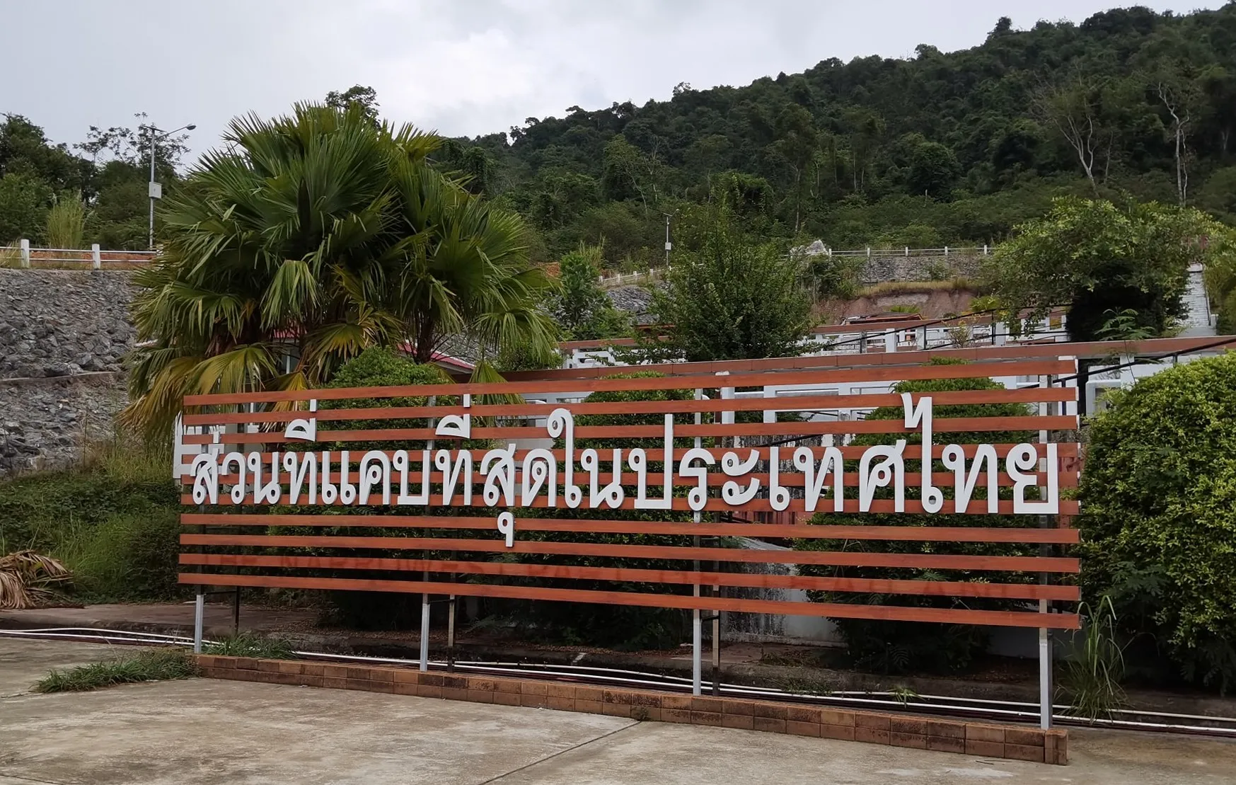
The landmark sign is one of the most important features of the site. It clearly identifies the location as the narrowest part of Thailand and serves as the main photo point for visitors. Many travelers stop here to take a commemorative photo before continuing toward Hat Lek or returning north toward Khlong Yai and Trat town. The simplicity of the place is part of its charm. It does not need large buildings or complex attractions because the geographical fact itself is the main highlight.
For educational travel, this site is a useful example of field geography. Students, teachers, and travelers can use the location to understand coastal landforms, natural borders, border mountains, the relationship between roads and frontier communities, and the way a small geographical feature can become a tourism landmark. Standing at the site helps visitors understand Thailand’s map more clearly than looking at a flat illustration in a textbook.
One side of the landmark is connected to the Gulf of Thailand, while the other side is connected to the Banthat Mountain Range and the Thai-Cambodian border zone. The short distance between these two major geographical features creates a strong sense of place. Travelers can imagine that this stretch of Thai territory is only a few hundred meters wide, with a road running through the narrow strip between sea and mountain.
The name Ban Khot Sai reflects the coastal character of the area, with references to sand, rocky ground, and the seaside environment. Communities in Hat Lek and Khlong Yai have long been connected to the sea, fisheries, border trade, and routes to Cambodia. A stop at the narrowest part of Thailand therefore offers more than a geographical photo. It also introduces visitors to the atmosphere of a coastal border community that differs from the inland parts of Trat Province.
The Trat-Khlong Yai road is a scenic and interesting route. It passes coastal communities, fishing areas, rubber plantations, fruit orchards, mountain views, and roadside viewpoints before reaching the southern end of Khlong Yai District and Hat Lek Subdistrict. The Narrowest Part of Thailand fits naturally into this route. Travelers can start from Trat town, drive south toward Khlong Yai, stop at Ban Khot Sai, and then continue to Ban Hat Lek Border Market or Ban Chuen Beach.
For photography, the best times to visit are in the morning and late afternoon. The light is softer, the heat is less intense, and the surrounding landscape can be photographed more comfortably. Visitors often take photos with the landmark sign, the road, the greenery, and the mountain backdrop. In the late afternoon, the coastal atmosphere can feel especially calm, making the site a pleasant short stop on the way to or from the border.
Although the site is not a large tourist complex, it has strong value as a geographical check-in point. Visitors can clearly say they have stood at the narrowest part of Thailand, where the country measures only 450 meters across. This clear and memorable fact gives the place its identity. Its simplicity makes the experience direct and easy to understand.
For travelers interested in history and geopolitics, Hat Lek Subdistrict adds further context. The area is close to Ban Hat Lek permanent border checkpoint, which connects Thailand with Cambodia’s Koh Kong area. This border route has long been important for travel, trade, and cross-border movement. The fact that Thailand’s narrowest point lies close to this border zone makes the landmark more meaningful, linking geography with frontier travel and the role of Trat as a maritime border province.
From this point, travelers can continue to Ban Hat Lek Border Market, one of the important border market areas in Trat, or drive back toward Ban Chuen Beach, a quiet beach in Khlong Yai District known for its soft sand and relaxed atmosphere. Other nearby destinations include the Khao Lan Thai Red Cross Centre, Ratchakarun Beach, Pailin Beach, and coastal communities in Khlong Yai. This makes the narrowest part of Thailand a practical stop within a wider southern Trat itinerary.
In terms of facilities, this is best understood as a roadside landmark rather than a full-scale attraction. Visitors should bring drinking water, sun protection, and a hat if visiting during the day. Since the site is close to the main road, travelers should park carefully, avoid blocking traffic, and remain aware of passing vehicles while taking photos. Families with children should take extra care near the roadside.
The advantage of visiting this landmark is that it does not require much time. Most travelers spend about 15–30 minutes taking photos, reading the sign, observing the landscape, and appreciating the unusual geography before continuing their journey. It is suitable for road trippers, photographers, students, families, and travelers who enjoy places with a clear and unusual story.
Getting There from Trat town is most convenient by private car or rental car. Follow the Trat-Khlong Yai route south toward Khlong Yai District and Hat Lek Subdistrict. The landmark is located at Ban Khot Sai, Moo 2, around kilometer markers 81–82. Travelers can search for “The Narrowest Part of Thailand” or the Thai name “ส่วนที่แคบที่สุดในประเทศไทย” on a navigation map. The route is suitable for a day trip from Trat town or for a stop on the way to Khlong Yai and Ban Hat Lek Border Market.
Travelers coming from Trat town should allow enough time because the location is relatively far from the city. Some parts of the route follow the coast and should be driven carefully. A private vehicle or rental car is the most practical option, as it allows travelers to stop at beaches, border markets, viewpoints, and local restaurants along the way.
Restaurants in Khlong Yai and Hat Lek include seafood restaurants, local Thai food shops, noodle shops, and beach cafés. Visitors who want more dining choices should plan meals around Hat Lek, Khlong Yai town, or Ban Chuen Beach rather than relying only on the immediate landmark area. For accommodation, travelers can stay around Khlong Yai, Ban Chuen Beach, Pailin Beach, or areas closer to Ban Hat Lek, depending on the overall travel plan.
This landmark is also suitable for international travelers because the concept is easy to understand: The Narrowest Part of Thailand. Foreign visitors traveling toward the Hat Lek border or onward to Cambodia can stop here conveniently and gain a clearer sense of Thailand’s eastern geography. It shows that Thailand is not only about cities, temples, beaches, and islands, but also about unique geographical features that tell stories of land, border, sea, and mountains.
In summary, the Narrowest Part of Thailand in Trat Province is a small but meaningful landmark. Located at Ban Khot Sai, Hat Lek Subdistrict, Khlong Yai District, around kilometer markers 81–82, it measures only 450 meters from the Gulf of Thailand coastline to the Thai-Cambodian border mountains. It is ideal for photography, geography learning, short roadside stops, and travel routes connecting Khlong Yai, Hat Lek, Ban Chuen Beach, and Ban Hat Lek Border Market.
| Name | The Narrowest Part Of Thailand |
| Location | Ban Khot Sai, Moo 2, Hat Lek Subdistrict, Khlong Yai District, Trat Province |
| Address | Around Kilometer Markers 81–82, Trat-Khlong Yai Route, Ban Khot Sai, Moo 2, Hat Lek Subdistrict, Khlong Yai District, Trat Province 23110, Thailand |
| Highlights | A unique geographical landmark where Thai territory is only 450 meters wide from the Gulf of Thailand coastline to the Thai-Cambodian border along the Banthat Mountain Range. |
| History | The site is recognized as an important geographical point on the Trat-Khlong Yai route because the distance between the coastline and the border mountains is the narrowest part of Thailand. |
| Name Origin | The name comes from the actual landform, where this stretch of Thai territory is only 450 meters wide, giving it the title “The Narrowest Part Of Thailand.” |
| Distinctive Features | A roadside geographical viewpoint located between the Gulf of Thailand and the Thai-Cambodian border mountains, with a clear landmark sign and photo point. |
| Width | 450 meters |
| Travel Information | Travel from Trat town along the Trat-Khlong Yai route toward Khlong Yai District and Hat Lek Subdistrict. The site is located at Ban Khot Sai around kilometer markers 81–82. Private car or rental car is recommended. |
| Current Status | Roadside travel landmark and photo stop on the Trat-Khlong Yai route, open for daily visits. |
| Open Days | Daily |
| Opening Hours | Open All Day |
| Fees | No Admission Fee |
| Facilities | Landmark sign, roadside photo stop, geographical viewpoint, and suitable roadside stopping area where available. |
| Main Areas / Zones | 1. Landmark Sign Area 2. Roadside Photo Point On The Trat-Khlong Yai Route 3. Geographical Viewpoint Between The Gulf Of Thailand And Banthat Mountain Range 4. Stopover Area Toward Khlong Yai And Hat Lek 5. Connecting Route To Ban Hat Lek Border Market And Ban Chuen Beach |
| Caretaker | Hat Lek Subdistrict Municipality, Khlong Yai District, Trat Province |
| Main Contact Number | Hat Lek Subdistrict Municipality Tel. 039-510-217 |
| Nearby Tourist Attractions | 1. Ban Hat Lek Border Market, about 8 km 2. Ban Hat Lek Permanent Border Checkpoint, about 8 km 3. Pailin Beach, about 9 km 4. Ban Chuen Beach, about 13 km 5. Khao Lan Thai Red Cross Centre, about 20 km 6. Ratchakarun Beach, about 20 km 7. Ruby Beach, about 21 km |
| Nearby Restaurants | 1. Poo Nim Restaurant Hat Lek, about 8 km 2. Good View Hat Lek, about 8 km 3. Sut Daen Siam Restaurant Khlong Yai, about 13 km 4. Nong Kaem Restaurant Khlong Yai, about 16 km 5. The Hi Ocean Cafe, Ban Chuen Beach, about 14 km 6. Vongole Beach Cafe, about 15 km |
| Nearby Accommodations | 1. Hadson Resort, about 15 km, Tel. 081-920-8934, 080-045-4505 2. The Hi Ocean Resort, about 16 km, Tel. 085-064-4647, 061-493-5979 3. Meet The Sea Resort, about 17 km, Tel. 099-099-0298 4. Hello Banchuen Beach, about 17 km 5. De VeraNiO Resort, about 18 km 6. Baan Chuen Beach Resort, about 17 km |
Frequently Asked Questions (FAQ)
Q: Where is the Narrowest Part of Thailand located?
A: It is located at Ban Khot Sai, Moo 2, Hat Lek Subdistrict, Khlong Yai District, Trat Province, around kilometer markers 81–82 on the Trat-Khlong Yai route.
Q: How wide is the Narrowest Part of Thailand?
A: It is only 450 meters wide, measured from the Gulf of Thailand coastline to the Thai-Cambodian border along the Banthat Mountain Range.
Q: What is interesting about this place?
A: It is a unique geographical landmark with a clear photo sign and a rare landscape where the sea and the border mountains are extremely close to each other.
Q: Is there an admission fee?
A: No. There is no admission fee for visiting the roadside landmark and photo point.
Q: How do travelers get there from Trat town?
A: Travel south from Trat town along the Trat-Khlong Yai route toward Hat Lek Subdistrict. The landmark is located at Ban Khot Sai around kilometer markers 81–82. A private car or rental car is recommended.
Q: What is the best time to visit?
A: Morning and late afternoon are good times for photography because the light is softer and the surrounding landscape is easier to enjoy.
Q: What attractions are nearby?
A: Nearby attractions include Ban Hat Lek Border Market, Ban Hat Lek Permanent Border Checkpoint, Pailin Beach, Ban Chuen Beach, Khao Lan Thai Red Cross Centre, Ratchakarun Beach, and Ruby Beach.
Q: Is this place suitable for international travelers?
A: Yes. It is easy to understand as The Narrowest Part of Thailand and makes a convenient stop on the way to Hat Lek, Khlong Yai, or the Cambodia border.
 Category: ●Nature and Wildlife
 Group: ●Other natural attractions
Last Update : 4 MonthAgo
 Last Update : 4 MonthAgo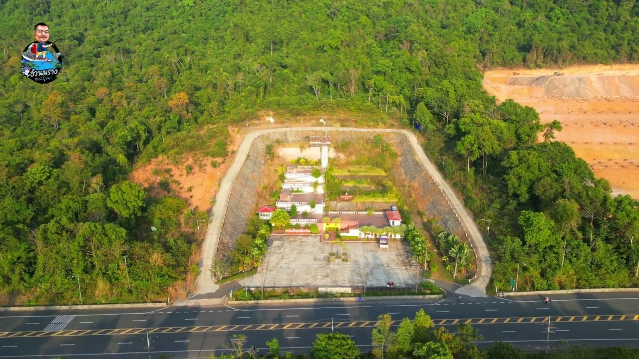
 Click to Access the Navigation Map GPS
Narrowest Part of Thailand Map
Recommend

 Art, Culture and Heritage
 Historical Sites and Monuments(1)
 Landmarks and Memorials(1)
 Art, Craft Centres, Tradition(3)
 Museums(2)
 Educational Places
 Museum for Study(1)
 Educational Gardens, Farm(2)
 Places of Worship
 Temple(11)
 Mosque(2)
 Other Sacred Sites(2)
 Suburban Living
 Village, Community(6)
 Local Market(2)
 National Parks and Marine Reserves(2)
 Mountain (Doi)(1)
 Dam, Reservoir, Lake(3)
 Waterfalls(15)
 River, Canal(1)
 Bays and Beaches(21)
 Islands(19)
Other natural attractions(12)
Islands(19)
Other natural attractions(12)
 Entertainment and Agricultural
 Outdoor and Adventure Activities(1)
 Shopping
 Shopping and Night Market(1)


