
lovethailand home >Northeastern Travel Attractions >Udon Thani Travel Attractions >Muang Udon Thani >Khok Saat > Huai Luang Dam
TL;DR: Huai Luang Dam is located at Khok Sa-at Subdistrict, Mueang Udon Thani District, Udon Thani Province, open Daily, hours 08.30 – 16.30.
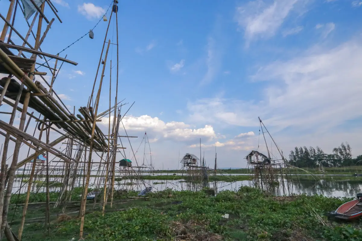
Huai Luang Dam
Open Days: Daily
Opening Hours: 08.30 – 16.30
Huai Luang Dam, also known as Huai Luang Reservoir, is one of the most important water resources and natural recreation areas in Udon Thani Province. Located in Khok Sa-at Subdistrict, Mueang Udon Thani District, it is within easy reach of Udon Thani city and can be accessed from the Udon Thani–Nong Bua Lam Phu route. The reservoir is widely known for its broad open-water scenery, long dam crest, peaceful wind, fishing, raft services, boat rides, and relaxed local atmosphere. It is suitable for travelers who want to experience a quiet water landscape close to the city while also learning how a major reservoir supports agriculture, fisheries, and water supply in northeastern Thailand.
Huai Luang Dam is not only a scenic attraction. It is a working earth-fill dam and a major water-management structure for Udon Thani. The reservoir stores water for irrigation, supports local agriculture, provides freshwater fish habitat, and serves as an important raw-water source for water-supply production in Udon Thani, Nong Wua So, and Kut Chap areas. This makes the dam a place where engineering, natural resources, local livelihoods, and tourism meet in a single landscape. Visitors who come here can enjoy the view while also understanding how deeply water systems support everyday life in the province.
The dam is especially impressive because of its scale. It is an earth-fill dam about 12.50 meters high, with a dam crest about 4.9 kilometers long. The reservoir area covers roughly 20,000 rai and can store about 113 million cubic meters of water. From the dam crest, visitors can see a wide expanse of water stretching across the landscape. One side of the road faces the reservoir, while the other side opens to green slopes and surrounding local scenery. This open and spacious atmosphere is the main reason Huai Luang Dam is popular for short scenic drives, photography, and sunset visits.
The history of Huai Luang Dam is closely connected with the development of irrigation in Udon Thani. Construction began in 1970. The main dam was completed in 1979, and the water distribution system was completed in 1984. The main purpose was irrigation, allowing water to be supplied to large agricultural areas during both the rainy and dry seasons. For farmers in the surrounding districts, the reservoir helps reduce dependence on irregular rainfall and supports cultivation planning. In this sense, Huai Luang Dam has played a practical role in supporting the agricultural economy of the province for decades.
The irrigation role of the dam is significant. It is recorded as being able to support about 94,830 rai of irrigated land in the rainy season and about 30,000 rai in the dry season. This makes the dam crucial for rice fields, crops, and other agricultural activities in the Huai Luang basin. The availability of stored water helps communities manage seasonal uncertainty and supports household income. Huai Luang Dam should therefore be understood not only as a reservoir but also as part of the agricultural foundation of Udon Thani.
The reservoir is also an important raw-water source for water-supply production. Water stored here contributes to tap-water production for Udon Thani and nearby districts such as Nong Wua So and Kut Chap. This means the reservoir is connected directly with urban life, households, schools, hospitals, businesses, and public services. The quality of the water and the condition of the reservoir environment are therefore important to a much wider community than the visitors who come to enjoy the scenery.
Freshwater fisheries are another important part of Huai Luang Reservoir. The broad water area supports fish breeding, local fishing, and fish-based food culture around the reservoir. Visitors may see fishing activities, raft services, and waterside restaurants connected with freshwater fish. These activities show that the reservoir remains a living ecosystem, not just a water-storage structure. Fish, birds, aquatic plants, local fishermen, and visitors all form part of the everyday landscape of Huai Luang.
The dam crest is the best-known viewpoint. Visitors can drive along the crest, pause at suitable areas, enjoy the wind, take photos, and look across the reservoir. The long straight road, the wide water surface, the sky, and the green surroundings create a simple but memorable visual experience. Late afternoon is especially attractive because the light becomes softer and the water reflects the sky. Many visitors come here just to relax, take photos, and enjoy a quiet break from the city.
The beauty of Huai Luang Dam changes by season. In the rainy season and shortly after, the reservoir is fuller, the surrounding landscape is greener, and the sky often has dramatic clouds. The cool season is pleasant for driving, walking, and resting by the water. In the hot season, the open water still gives a sense of space and relief, although visitors should avoid the strongest midday heat. Morning and late afternoon are the most comfortable times to visit because the weather is cooler and the light is better for photography.
Activities at Huai Luang Dam range from simple sightseeing to water-based recreation. Visitors can drive along the dam, walk in safe areas, take photos, enjoy the breeze, watch the sunset, eat near the reservoir, fish, take a boat ride, or use raft services provided by local operators. This variety makes the dam suitable for families, groups of friends, photographers, local residents, and travelers who prefer relaxed nature trips rather than strenuous outdoor activities.
Rafting and boat activities allow visitors to see the reservoir from the water. This gives a different perspective from viewing the scenery from the dam crest. Visitors who want to use raft services should contact operators in advance, especially on weekends and holidays. Safety should always come first. Life jackets should be used when appropriate, alcohol should be avoided during water activities, and rubbish must never be thrown into the reservoir. Responsible recreation helps keep the reservoir clean and safe for everyone.
Fishing is also popular at Huai Luang Dam because the reservoir is known as a freshwater fish habitat. Visitors who fish should respect local rules, avoid restricted areas, and leave no fishing lines, hooks, plastic, or food waste behind. A good fishing visit should protect the water, the fish, and the surrounding ecosystem. The reservoir supports community livelihoods, so responsible behavior benefits both nature and local people.
Inside the reservoir area is also a royal residence associated with Her Royal Highness Princess Srinagarindra, the Princess Mother, who visited and stayed in the area in the past. This adds a historical and memorial dimension to Huai Luang Dam. Visitors interested in this aspect should respect the place and follow local instructions. The presence of this royal association gives the reservoir additional meaning beyond irrigation and recreation.
The dam is also important during both wet and dry seasons because water levels must be managed carefully. In years with heavy rainfall, the reservoir is monitored to reduce downstream impacts. In dry years, stored water becomes essential for irrigation and water supply. This dual role makes Huai Luang Dam a central part of water management in the area. Visitors can enjoy the scenery, but the reservoir’s deeper value lies in how it helps balance water needs across communities, agriculture, and urban use.
Nearby communities such as Khok Sa-at, Nikhom Song Khro, and the areas toward Nong Wua So are closely connected with the reservoir. Local people benefit from water, fisheries, agriculture, restaurants, services, and recreation connected with the dam. The site is therefore shared by many groups: local residents, farmers, fishermen, restaurant operators, raft operators, cyclists, photographers, and tourists. Visitors should use the area politely, avoid blocking local roads, and respect community space.
For photography, Huai Luang Dam offers many strong compositions: the road along the dam crest, wide water views, sunset skies, reflections, raft scenes, fishing activity, grass along the embankment, and open local landscapes. The best time for photography is early morning or late afternoon. Visitors should avoid standing in unsafe road positions or parking in a way that obstructs traffic. Safety matters because the dam crest is also used for local movement.
For families, the dam is a useful place for children to learn about reservoirs, irrigation, fisheries, and water supply. Children can see how a large body of water supports a province. However, adults should supervise children closely near the water, on the dam crest, and during any boat or raft activity. Huai Luang Dam is best enjoyed through viewing, learning, and safe recreation rather than unsupervised water play.
For older visitors, Huai Luang Dam is easier to access than waterfalls or mountain trails. Visitors can arrive by car, enjoy the view, rest, and leave without difficult walking. A short morning or late-afternoon visit is enough to enjoy the wind and water scenery. This makes the dam suitable for relaxed city-based travel and family trips with mixed age groups.
Environmental care is essential because Huai Luang Dam is a water-supply source, irrigation reservoir, fish habitat, and public recreation area. Plastic waste, food scraps, oil, and polluted water can affect water quality and the ecosystem. Visitors should take rubbish back or use proper disposal points, avoid throwing anything into the water, avoid releasing non-native aquatic animals, and avoid damaging shoreline plants. Keeping the reservoir clean protects both the tourist attraction and the water resource of Udon Thani.
Getting There from Udon Thani city is straightforward. Take the Udon Thani–Nong Bua Lam Phu route and turn off near kilometer 15, then continue for about 10 kilometers toward the reservoir area in Khok Sa-at Subdistrict. The distance from Udon Thani city is about 20 to 25 kilometers depending on the starting point, and the drive usually takes around 30 to 45 minutes. Private car, motorcycle, rental car, or hired vehicle are the most convenient options.
Drivers should be careful on local access roads and on the dam crest. Parking should be done only in safe areas that do not block traffic or create risk near the edge of the road. Those planning raft or boat activities should contact service providers in advance and follow safety instructions. On holidays, visitors should allow extra time because local traffic and recreation activity can be heavier than usual.
Huai Luang Dam can be included in several Udon Thani travel routes. Visitors who want nature and photography can combine the dam with flower gardens in the Huai Samran or Khok Sa-at area. Visitors who want a city route can return to Nong Prajak Public Park, Udon Thani City Museum, Chao Pu-Ya Shrine, and the Thai-Chinese Cultural Center. Those who want a relaxed route can include cafés, restaurants, or accommodation in Nikhom Song Khro, Khok Sa-at, Nong Wua So, or central Udon Thani.
The advantage of Huai Luang Dam is flexibility. A short visit can take less than one hour for scenic viewing and photography. A longer visit can include food, raft activity, fishing, or a boat ride. Families can enjoy a safe rest stop, photographers can wait for the evening light, and travelers interested in local systems can understand how a dam supports agriculture, fisheries, and water supply.
For Thai visitors, Huai Luang Dam reveals Udon Thani as a province supported by a major water resource, not only by temples, markets, archaeology, and cultural sites. For international visitors, the dam offers a clear example of an earth-fill reservoir in northeastern Thailand that supports agriculture, tap-water production, fisheries, and everyday recreation. It provides a more practical and grounded understanding of local life in the region.
Overall, Huai Luang Dam is both a meaningful water-management site and a scenic natural attraction near Udon Thani city. It is easy to reach, free to visit, and suitable for morning and late-afternoon relaxation. With its long dam crest, wide reservoir, fishing activity, raft services, water-supply role, and community connections, it is one of the most complete local nature destinations for visitors who want to understand Udon Thani through water, landscape, agriculture, and everyday life.
| Name | Huai Luang Dam / Huai Luang Reservoir |
| Location | Khok Sa-at Subdistrict, Mueang Udon Thani District, Udon Thani Province |
| Address | Huai Luang Dam, Khok Sa-at Subdistrict, Mueang Udon Thani District, Udon Thani 41000, Thailand |
| Highlights | Large earth-fill dam, long dam crest, wide reservoir, scenic viewpoint, freshwater fish habitat, raw-water source for tap-water production, raft services, fishing, boat rides, and sunset views |
| History / Background | Construction began in 1970. The main dam was completed in 1979, and the water distribution system was completed in 1984. The reservoir was built for irrigation, agriculture, fisheries, and raw-water supply. |
| Dam Features | Earth-fill dam, about 12.50 meters high, dam crest about 4.9 km long, reservoir area about 20,000 rai, and storage capacity about 113 million cubic meters |
| Area Importance | Irrigation water source for agricultural areas, raw-water source for tap-water production in Udon Thani, Nong Wua So, and Kut Chap, freshwater fish breeding area, and local recreation landscape |
| Travel Information | From Udon Thani city, take the Udon Thani–Nong Bua Lam Phu route and turn off near kilometer 15, then continue about 10 km to the reservoir. The distance from the city is about 20–25 km and usually takes around 30–45 minutes by car. |
| Current Status | Open for visitors as an irrigation reservoir, freshwater fishery area, scenic viewpoint, and natural recreation area in Udon Thani Province |
| Open Days | Daily |
| Opening Hours | 08.30 – 16.30 |
| Fees | No admission fee |
| Facilities | Parking, restrooms, shops, food, scenic viewpoint, dam-crest road, reservoir recreation areas, raft and boat services according to local operators |
| Main Areas / Zones | Huai Luang Dam crest Reservoir viewpoint area Reservoir and shoreline area Raft and boat activity area Fishing area Food and shop area Royal residence area associated with Princess Srinagarindra according to site management Khok Sa-at and Nikhom Song Khro surrounding communities |
| Suitable Activities | Scenic driving, walking on the dam crest, photography, enjoying the breeze, sunset viewing, rafting, boat rides, fishing, waterside dining, and family or group recreation |
| Caretaker | Royal Irrigation Department, Ministry of Agriculture and Cooperatives, through the Huai Luang Operation and Maintenance Project, Regional Irrigation Office 5, with local authorities in Khok Sa-at and Nikhom Song Khro areas |
| Main Contact Number | Tourism Authority of Thailand, Udon Thani Office, Tel. 0-4232-5406, 0-4232-5407 Huai Luang Dam raft service, Tel. 081-061-9374 Nikhom Song Khro Municipality, Tel. 042-237-134 |
| Nearby Tourist Attractions | 1. Huai Luang Dam Crest, about 0.1 km 2. Huai Luang Dam Raft Area, about 0.5 km, Tel. 081-061-9374 3. Bank Benjamas Flower Garden Udon Thani, about 8 km, Tel. 088-508-4071 4. Lek’s Fishing Park Udon Thani, about 14 km 5. Nong Prajak Public Park, about 25 km 6. Thai-Chinese Cultural Center Udon Thani, about 28 km, Tel. 042-242-444, 042-242-333, 082-707-0666 |
| Nearby Restaurants | 1. Chao Khuean Huai Luang Restaurant, about 1 km, Tel. 042-678-900 2. Mala Khun Luang, about 2 km, Tel. 088-747-7123 3. Phae Klang Nam Restaurant, about 18 km, Tel. 089-687-3368 4. Hidden Cafe & Restaurant Udonthani, about 18 km, Tel. 081-583-0175 5. Nong Wua So Boat Noodles, about 20 km, Tel. 088-539-8627 6. Nong Wua So Resort And Restaurant, about 22 km, Tel. 042-285-700, 089-711-3789 |
| Nearby Accommodations | 1. Fahluang Resort Khok Sa-at, about 8 km 2. GoodHome Resort Udonthani, Nikhom Song Khro, about 16 km, Tel. 081-954-1840 3. Nong Wua So Resort, about 22 km, Tel. 042-285-700, 089-711-3789 4. Tanita Lagoon Resort, about 24 km, Tel. 086-630-8828, 089-171-8199 5. Haus Hotel Udon Thani, about 25 km, Tel. 042-211-189 6. Accommodations In Udon Thani City, about 25–30 km |
Frequently Asked Questions (FAQ)
Q: Where is Huai Luang Dam located?
A: Huai Luang Dam is located in Khok Sa-at Subdistrict, Mueang Udon Thani District, Udon Thani Province, accessible from the Udon Thani–Nong Bua Lam Phu route.
Q: What are the opening hours of Huai Luang Dam?
A: Huai Luang Dam is open daily from 08.30 to 16.30.
Q: Is there an admission fee?
A: No. There is no admission fee. Expenses depend on transport, food, drinks, raft services, boat rides, or other optional services.
Q: Why is Huai Luang Dam important?
A: It is an earth-fill dam and large reservoir used for irrigation, agriculture, freshwater fisheries, and raw-water supply for tap-water production in Udon Thani, Nong Wua So, and Kut Chap areas.
Q: What activities are suitable at Huai Luang Dam?
A: Suitable activities include scenic driving, walking on the dam crest, photography, enjoying the breeze, sunset viewing, rafting, boat rides, fishing, and waterside dining.
Q: What is the best time to visit Huai Luang Dam?
A: Morning and late afternoon are the best times because the weather is cooler, the light is softer, and the reservoir scenery is more suitable for relaxation and photography.
Q: How can visitors travel from Udon Thani city to Huai Luang Dam?
A: Take the Udon Thani–Nong Bua Lam Phu route and turn off near kilometer 15, then continue about 10 km to the reservoir. The drive from Udon Thani city usually takes about 30–45 minutes.
Q: What nearby places can be visited with Huai Luang Dam?
A: Visitors can combine Huai Luang Dam with Bank Benjamas Flower Garden, Lek’s Fishing Park, Nong Prajak Public Park, the Thai-Chinese Cultural Center, and restaurants or cafés around Nikhom Song Khro, Khok Sa-at, and Nong Wua So.
 Category: ●Nature and Wildlife
 Group: ●Dam, Reservoir, Lake
Last Update : 1 MonthAgo
 Last Update : 1 MonthAgo
 Click to Access the Navigation Map GPS
Huai Luang Dam Map
Gellery
Recommend

 Art, Culture and Heritage
 Historical Sites and Monuments(1)
 Landmarks and Memorials(1)
 Art, Craft Centres, Tradition(2)
 Museums(2)
 Places of Worship
 Temple(21)
 Other Sacred Sites(8)
 Suburban Living
 Village, Community(3)
 National Parks and Marine Reserves(3)
 Mountain (Doi)(1)
Dam, Reservoir, Lake(8)
Mountain (Doi)(1)
Dam, Reservoir, Lake(8)
 Waterfalls(6)
 Caves(1)
 River, Canal(4)
 Islands(1)
 Other natural attractions(1)
 Entertainment and Agricultural
 Farms, Parks and Ecotourism(3)
 Waterpark(1)
 Shopping
 Shopping and Night Market(1)


