
lovethailand home >Northeastern Travel Attractions >Nakhon Phanom Travel Attractions >Tha Uthen >Chai Buri > Chai Buri River
TL;DR: Chai Buri River is located at Mouth of the Songkhram River, Ban Chai Buri–Ban Tan Pak Nam, Chai Buri Subdistrict, Tha Uthen District, Nakhon Phanom Province, Thailand, open Daily, hours 08:00 – 18:00.
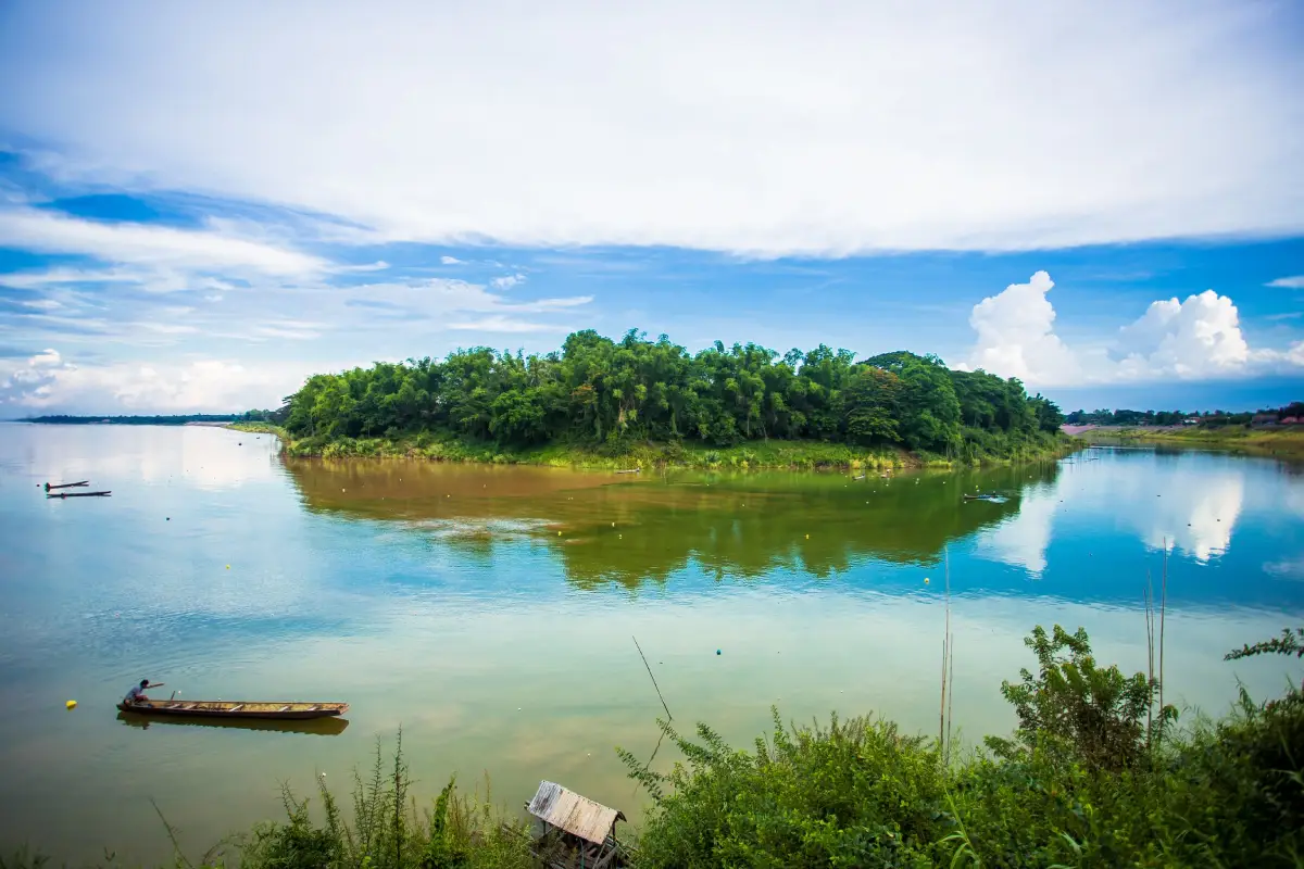
Chai Buri River
Open Days: Daily
Opening Hours: 08:00 – 18:00
Chai Buri River Confluence in Nakhon Phanom Province, commonly known as the Chai Buri Two-Colored River Viewpoint, is a distinctive natural and cultural attraction in Chai Buri Subdistrict, Tha Uthen District. It stands at the mouth of the Songkhram River, where the tributary enters the much larger Mekong River. Under suitable light and water conditions, visitors can see two noticeably different water colors flowing beside one another. The Songkhram normally appears green or blue-green, while the sediment-rich Mekong appears brown or reddish-brown. The two currents gradually mix downstream, creating a constantly changing landscape beside an old riverside community.
Essential information for travelers The viewpoint is open daily from 08:00 to 18:00 and there is no admission fee. It lies around Ban Chai Buri and Ban Tan Pak Nam in Chai Buri Subdistrict, Tha Uthen District, at approximately 17.653274, 104.464091. The site is about 46 kilometres north of Nakhon Phanom city and approximately 18 kilometres from Tha Uthen town. A private car, rental vehicle, or motorcycle is the most convenient form of transportation. The area contains a river viewpoint, a restaurant specializing in freshwater fish, homestay accommodation, parking, resting space, historic temples, a local monument, and access to the wider Chai Buri community.
The central appeal of Chai Buri lies in witnessing a tributary reach the end of its journey and enter a major international river. The Songkhram is one of the most important rivers of upper northeastern Thailand. It passes through wetlands, seasonally flooded grasslands, tributaries, and floodplain forest before reaching the Mekong at Chai Buri. The Mekong, by contrast, is a vast transboundary river flowing through several countries and forming the international boundary between Thailand and Lao PDR in this area.
As water from the Lower Songkhram wetlands reaches the river mouth, it enters a current with a different speed, volume, temperature, sediment load, and chemical composition. The two bodies of water do not mix instantly. For a period, green or blue-green water from the Songkhram can be seen beside the brown and reddish-brown Mekong. The boundary moves continuously before both colors gradually become part of the same downstream current.
Why are there two different colors? The effect is a physical river process rather than an artificial or mysterious phenomenon. The Mekong drains an enormous area and transports fine sediment from many landscapes, giving it brown, yellow-brown, or reddish-brown tones. The Songkhram flows through inland wetlands, floodplains, vegetation, and tributaries in northeastern Thailand. Its water often appears green, blue-green, or dark depending on organic material, depth, surrounding vegetation, and the reflection of the sky.
Local descriptions sometimes call the colors blue and red because these terms provide a simple visual image. At the actual site, the precise tones change according to sunlight, cloud cover, season, water depth, and viewing angle. On a clear morning, the Songkhram may reflect the sky and appear more blue-green. The Mekong, carrying suspended sediment, may look reddish-brown. Under cloudy skies or during high water, both colors become darker and the visible boundary shifts.
The two-color line is not identical every day or throughout the entire day. When the flow of the Songkhram and Mekong is similar, the currents may mix more rapidly. When one river carries substantially more water, its current pushes the meeting line toward a different part of the channel. Visitors should observe the river from several positions and allow time for the changing light rather than expecting the confluence to look exactly like a particular photograph.
The best time of day to see the confluence is generally from 08:00 to 10:00 and from approximately 15:30 to 18:00. Morning provides softer light, lower temperatures, and a stronger reflection of the sky on the Songkhram. Late-afternoon side lighting can emphasize differences in surface texture and color. Photographers should allow at least one or two hours so that changes in cloud, wind, current, and sunlight can produce a clearer view.
During the rainy season, both rivers rise and flow more strongly. Sediment increases in the Mekong, deepening its brown or reddish-brown color. The Songkhram receives water from tributaries, flooded forests, and wetland areas, causing the boundary between the currents to change position quickly. The river scenery is powerful and expansive, but visitors must remain inside safe viewing areas and avoid any eroded riverbank.
The late rainy season and early cool season provide another rewarding period. Water levels begin to stabilize, road conditions improve, and the temperature becomes more comfortable. The two rivers may still show a marked contrast because of differences in sediment and drainage from the Songkhram Basin. From November through February, visitors can sit beside the river, eat local fish dishes, stay in a homestay, and enjoy the morning landscape without extreme heat.
During the dry season, the Mekong falls and exposes parts of the riverbank, sand deposits, and temporary bars. The Songkhram also carries less water, producing a different confluence pattern. Although the river is no longer full to the banks, visitors can see the shape of the river mouth, channels, and sediment deposits more clearly. This season is useful for understanding the physical geography of the area and observing changes in local fishing activity.
The Lower Songkhram wetland system is one of the most ecologically significant landscapes in northeastern Thailand. It includes the river, tributaries, ponds, marshes, seasonally flooded grassland, and flooded forest locally known as pa bung pa tham. During high water, low-lying forests and fields become aquatic habitats where fish can feed, breed, and grow. As the water falls, many fish and other aquatic animals move back toward the main river and the Mekong.
The connection between the Songkhram and the Mekong allows numerous fish species to migrate between the main channel and inland wetlands. This seasonal movement supports biodiversity, household food security, and traditional fisheries. The abundance of fish at Chai Buri therefore depends on the health of the entire Songkhram Basin, including floodplain forests, tributaries, wetlands, and seasonal water cycles, rather than the river mouth alone.
Fish use the confluence as a migration route, feeding area, and transition zone between waters with different characteristics. The meeting currents bring nutrients, sediment, insects, plants, and small aquatic organisms together. This natural concentration of food supports fish, waterbirds, and other wildlife and provides the ecological foundation for traditional fishing and the well-known freshwater cuisine of Chai Buri.
Freshwater fish and local food are central to a visit. Local restaurants serve dishes such as steamed fish, spicy fish salad, fish soup, fish cooked in banana leaves, fried fermented fish, and seasonal community recipes. The food demonstrates practical knowledge of preservation, fermentation, herbs, and river resources. Pla som, or fermented fish, is especially associated with communities throughout the Songkhram Basin.
The available fish changes according to season, legal fishing periods, and the daily catch. Diners should ask about the species, preparation, weight, and price before ordering. Larger river fish are often priced by weight, so the restaurant should confirm the size and total price before cooking. This prevents confusion and allows visitors to choose an appropriate amount for their group.
Supporting community restaurants should be combined with responsible consumption. Travelers should not encourage fishing in closed seasons or conservation zones, purchase undersized fish, or consume protected species. Asking restaurant staff about the origin of ingredients and choosing legally harvested fish helps maintain both local livelihoods and aquatic biodiversity.
Chai Buri and Tai Yo culture give the destination significance beyond the natural viewpoint. Chai Buri is an old community with an important Tai Yo population. Residents have maintained local speech, food, Buddhist traditions, kinship networks, and riverside livelihoods. Walking through the settlement reveals homes, temples, fishing areas, and a daily relationship with both the Songkhram and Mekong rivers.
The Tai Yo possess a distinctive spoken language and cultural identity. Although modern employment and education have transformed everyday life, Buddhist festivals, local food, family networks, and community ceremonies remain important. Annual temple events bring residents and family members together for merit-making and cultural activity.
Visitors should respect private homes, fishing landings, boats, and working areas. Do not enter a house or photograph a person without permission. Buying food, souvenirs, fermented fish, or community products provides direct support to local households, but prices should be treated fairly rather than negotiated to a level that harms small producers.
The history of Chai Buri is connected with settlement, river transport, and political organization in the Mekong region. The confluence offered access to fishing, travel routes, and agricultural land, making it suitable for a community and former town. Historical memory survives in monuments, temples, archaeological remains, and stories passed through local families.
The Phra Chai Ratchawongsa Monument, also associated with Ratchabut Sen, commemorates the first ruler of the former town of Chai Sut Uttama Buri. It stands close to the confluence and provides a useful introduction to local history. Travelers can continue from the monument to Wat Klang Mueang Chai Buri and Wat Tai Mueang Chai Buri, connecting the landscape of the rivers with the historical organization of the town.
Wat Klang Mueang Chai Buri is an important historic temple containing an old stupa or chedi and archaeological evidence associated with the former settlement. The quiet temple grounds remain part of the religious life of the community. Visitors must dress modestly, avoid climbing old structures, and never touch or remove inscriptions, bricks, religious objects, or archaeological material.
Wat Tai Mueang Chai Buri provides another link with the historical geography of the town. Its name identifies its position south of the former central area. Like other local temples, it remains both a religious place and a community space, so visitors should remain quiet and avoid interrupting ceremonies or daily monastic activity.
The main confluence viewpoint is the best area for studying the direction and texture of the currents. Visitors can watch foam, floating leaves, small debris, and color lines moving continuously across the water. Polarized sunglasses can reduce surface glare and make the boundary easier to see, but nobody should move onto a slippery ledge or unstable riverbank for a closer angle.
The restaurant and homestay zone is located beside the viewpoint. Pak Nam Chai Buri Restaurant serves freshwater fish and local dishes with a view over the confluence. Its business hours are separate from the public viewpoint. Groups and overnight visitors should reserve in advance, particularly during weekends, cool-season travel, and community festivals.
The old community zone is suitable for slow walking and observation of local life. It is not an entirely commercial tourism district, so noise should be kept low and private property respected. Speaking with local vendors and purchasing community products helps distribute economic benefits beyond the principal viewpoint.
The fishing and boat area is a workplace rather than an unrestricted visitor attraction. Nets, hooks, engines, boats, and steep river access points present safety risks. Observe from a distance and do not move fishing equipment. Any tourism boat activity must use an authorized operator with appropriate safety equipment.
Photographing the two-colored river is most effective from a position slightly above the water. A wide image can show the Songkhram mouth, the Mekong, and the riverside community, while a zoom lens helps capture the color boundary, boats, and current patterns. Morning produces softer light, while late-afternoon side lighting can emphasize movement on the river surface.
Tripods must not obstruct paths or dining areas. Never climb a barrier or stand on an unstable river edge for a photograph. Drones must not be flown across the Mekong or international boundary and may be used only in compliance with Thai aviation law, registration rules, local permission, and border-security requirements.
River safety remains essential even when the confluence appears calm. Both rivers contain deep channels and strong currents that change seasonally. Swimming, diving, or attempting to cross a shallow-looking section is unsafe. Children must remain with an adult, and nobody should sit on a barrier or move outside a protected viewing area.
During floods, parts of the riverbank can weaken or erode. Ground that appears firm may collapse under weight. Visitors must not descend onto a flooded stairway, muddy bank, or area closed by local authorities. Barriers and warning signs must be obeyed immediately.
Dry-season sandbanks should not be entered without authorization. Firm-looking sand may conceal deep mud or unstable deposits, and the river level can change because of current and boat movement. The Mekong is also an international border zone, so access to a bar or island must be part of an officially permitted activity.
Border regulations prohibit unauthorized river crossings, private boat travel to Laos, walking across sandbanks, or flying a drone into Lao airspace. International travel must use an official checkpoint with valid immigration and customs documents. The visual closeness of the opposite bank does not permit unrestricted crossing.
General landscape photography is possible from the public viewpoint, but security officers, checkpoints, patrol boats, and restricted installations should not be photographed in a disruptive manner. If an officer requests that photography stop or that a person leave a particular area, the instruction must be followed.
Responsible tourism begins by preventing waste from reaching either river. Plastic bottles, bags, food containers, foam, cigarette filters, and paper can be carried away by wind or rain. Use the available bins, and when a bin is full, take the waste to another disposal point rather than leaving it beside the container.
Food scraps, cooking oil, drinks, detergent, and other liquids should never be poured into the river. Food waste can change fish behavior, while oil and chemicals reduce water quality. After eating beside the river, check the table and ground carefully for packaging or small pieces of waste.
Fishing must follow Thai law, seasonal restrictions, permitted equipment, and community conservation rules. Hooks and lines should not be placed in a visitor walkway. Protected species must not be bought or sold, and destructive fishing methods involving electricity, poison, chemicals, or explosives are strictly unacceptable.
What to bring includes comfortable walking shoes, a hat, drinking water, sunscreen, a compact rain jacket or umbrella, personal medication, and a camera. A light jacket is useful during the cool season. Rainy-season visitors should use footwear with good grip because surfaces beside the water can become slippery.
Phones should be fully charged, and an offline map is useful when driving through rural areas. Fill the vehicle with fuel in Nakhon Phanom or Tha Uthen and check tires and brakes before continuing toward Chai Buri. Mobile reception may vary along local roads and beside the river.
A two-to-three-hour itinerary can begin at the confluence viewpoint, followed by lunch at Pak Nam Chai Buri Restaurant, a visit to the Phra Chai Ratchawongsa Monument, and a short stop at Wat Klang Mueang Chai Buri. This schedule suits travelers passing through Tha Uthen without requiring an entire day.
A half-day itinerary can include the viewpoint in the morning, lunch in the community, Wat Klang Mueang Chai Buri, Wat Tai Mueang Chai Buri, and Nong Han Chai Buri Raft. It combines nature, history, Buddhism, food, and community life at a relaxed pace.
A full-day itinerary can start at Chai Buri before continuing south to Tha Uthen town. Travelers can visit Phra That Tha Uthen, Wat Trai Phum, the old Mekong community, and a riverside restaurant or accommodation. Distances are manageable, but time should be reserved for stopping, walking, and resting.
Nong Han Chai Buri Raft is another local recreation area in a natural wetland surrounded by trees and fields. Food, drinks, and raft services operate at selected times. The site is more suitable during the cool and dry seasons than during monsoon conditions. Current service should be confirmed with the local authority or operator.
Phra That Tha Uthen stands in Tha Uthen town and is regarded locally as the sacred stupa associated with people born on Friday. Its form resembles Phra That Phanom and it remains an important religious landmark. The route from Chai Buri continues directly toward Tha Uthen, making the temple a convenient addition to the journey.
Wat Trai Phum houses Phra Bang, a standing Buddha image in the gesture of calming the ocean. The image is important to the history and faith of the Tha Uthen community. The temple adds artistic and cultural depth to a confluence itinerary. Visitors should dress modestly and confirm access hours.
Restaurants near the viewpoint begin with Pak Nam Chai Buri Restaurant, located beside the confluence. It serves Thai, Isan, and freshwater fish dishes and normally operates from approximately 10:00 to 21:00. The property also offers homestay accommodation. Groups should reserve a table and ask which fish are available before arrival.
Other food and drink options are available in Chai Buri and Tha Uthen. PaiPraque Resort provides food, beverages, accommodation, and camping space. Tha Uthen has HA-O Cafe, PunThai Coffee, and Cafe Amazon. Opening days should be confirmed by telephone because small businesses may adjust their schedules.
Accommodation near Chai Buri ranges from the homestay directly beside the viewpoint to resorts within the subdistrict and riverside hotels in Tha Uthen. Pak Nam Chai Buri Homestay is the closest option for watching the confluence, while PaiPraque Resort suits travelers seeking a more natural outdoor atmosphere.
Travelers continuing to Phra That Tha Uthen and the historic town can choose Uthen Tara Resort, Tha Uthen Rim Khong Hotel, or Sun River Hotel Tha Uthen. Riverside accommodation is convenient for sunrise and early-morning exploration. Advance booking is recommended during the cool season, public holidays, and important Nakhon Phanom festivals.
Getting There from Nakhon Phanom city Follow Highway 212 north through Tha Uthen toward Ban Phaeng. The journey to Chai Buri is approximately 46 kilometres and normally takes 50–60 minutes. After passing Tha Uthen town, continue north and follow signs toward Chai Buri Subdistrict and the Two-Colored River Viewpoint.
Getting There from Tha Uthen Follow Highway 212 toward Ban Phaeng before turning onto the local road to Ban Chai Buri. The distance is approximately 18 kilometres and takes around 20–25 minutes. Most of the route is paved, although drivers should reduce speed inside villages and watch for motorcycles, pedestrians, children, and animals.
Public transportation is less convenient. Travelers can use a bus or local vehicle operating between Nakhon Phanom, Tha Uthen, and Ban Phaeng and get off near the Chai Buri junction. A local hired vehicle is then required for the final section. Confirm the pickup point, return schedule, telephone number, and fare before entering the community.
Management The public viewpoint is managed by Chai Buri Subdistrict Administrative Organization, which coordinates visitor information, local facilities, tourism promotion, and safety with Tha Uthen District, Nakhon Phanom Province, river authorities, and border agencies. The main contact number is 042-573-234.
Chai Buri is a destination where nature, ecology, history, food, and community culture meet in one landscape. Visitors can watch the Songkhram complete its journey into the Mekong, understand how sediment and current create the two-colored effect, and experience the productivity of the wetland system through traditional fishing and freshwater cuisine.
Traveling respectfully, remaining outside working fishing areas, removing waste, avoiding unauthorized entry into the river, and supporting local businesses will help preserve Chai Buri as a home, food-producing landscape, and valuable natural viewpoint for future generations.
| Name | Chai Buri River Confluence / Chai Buri Two-Colored River Viewpoint |
| Location | Mouth of the Songkhram River, Ban Chai Buri–Ban Tan Pak Nam, Chai Buri Subdistrict, Tha Uthen District, Nakhon Phanom Province, Thailand |
| Address | Chai Buri Subdistrict, Tha Uthen District, Nakhon Phanom 48120, Thailand |
| Coordinates | 17.653274, 104.464091 |
| Highlights | Green or blue-green Songkhram River water meeting the sediment-rich reddish-brown Mekong, together with traditional fisheries, freshwater cuisine, and an old Tai Yo community |
| Distinctive Features | A confluence where the Songkhram and Mekong have different sediment loads, current speeds, and light reflections, producing a visible two-color boundary |
| Ecological Importance | Connects the Mekong with the Lower Songkhram wetlands, supporting fish migration, breeding, feeding, and nursery habitats |
| Community and Culture | An old Tai Yo community with traditional fisheries, freshwater food, Buddhist temples, historic remains, and Mekong cultural traditions |
| Main Areas / Zones | 1. Two-Colored River Viewpoint 2. Pak Nam Restaurant and Homestay Zone 3. Phra Chai Ratchawongsa Monument Zone 4. Historic Chai Buri Community 5. Wat Klang Mueang and Wat Tai Mueang Zone 6. Community Fishing and Boat Area 7. Nong Han Chai Buri Raft Zone |
| Activities | Confluence viewing, photography, freshwater dining, fishing-culture learning, homestay accommodation, Tai Yo community visits, temple visits, and monument worship |
| Best Travel Period | Accessible throughout the year. Morning and late afternoon provide suitable light. November–February offers cooler weather, while the rainy season brings high water and stronger currents. |
| Open Days | Daily |
| Opening Hours | 08:00 – 18:00 |
| Admission Fee | Free admission. Food, accommodation, boat services, and privately operated activities are charged separately. |
| Facilities | Viewpoint, parking, resting areas, restaurant, homestay rooms, and toilets within nearby businesses |
| Travel Information | From Nakhon Phanom city, follow Highway 212 north through Tha Uthen toward Ban Phaeng and turn toward Chai Buri according to viewpoint signs. The distance is approximately 46 km. |
| Current Status | Open to visitors. Access to particular riverbank sections may be temporarily restricted during high water, erosion, maintenance, or safety operations. |
| Caretaker | Chai Buri Subdistrict Administrative Organization, Tha Uthen District, Nakhon Phanom Province |
| Main Contact Number | Chai Buri Subdistrict Administrative Organization: 042-573-234 |
| Official Information | Chai Buri Subdistrict Administrative Organization, Tha Uthen District, Nakhon Phanom Province |
| Safety | Do not swim, enter sandbanks without permission, disturb fishing equipment, cross the international river boundary, or fly a drone into Lao airspace. |
| Nearby Tourist Attractions | 1. Phra Chai Ratchawongsa Monument, 1 km, Local Information Tel. 042-573-234 2. Wat Klang Mueang Chai Buri, 1 km, Local Information Tel. 042-573-234 3. Wat Tai Mueang Chai Buri, 2 km, Local Information Tel. 042-573-234 4. Nong Han Chai Buri Raft, 5 km, Local Information Tel. 042-573-234 5. Phra That Tha Uthen, 18 km, Tha Uthen Municipality Tel. 042-581-599 6. Wat Trai Phum, 19 km, Tel. 097-454-3492 |
| Nearby Restaurants | 1. Pak Nam Chai Buri Restaurant, 0.1 km, Tel. 062-643-7802, 042-573-037 2. PaiPraque Resort & Cafe, 8 km, Tel. 065-838-8242 3. HA-O Cafe Tha Uthen, 18 km 4. PunThai Coffee Tha Uthen, 18 km, Tel. 093-321-1673 5. Cafe Amazon PTT Tha Uthen, 19 km, Tel. 098-585-9829 |
| Nearby Accommodations | 1. Pak Nam Chai Buri Homestay, 0.1 km, Tel. 062-643-7802, 042-573-037 2. PaiPraque Resort, 8 km, Tel. 065-838-8242 3. Uthen Tara Resort, 18 km, Tel. 081-031-4528 4. Tha Uthen Rim Khong Hotel, 18 km, Tel. 084-428-9883 5. Sun River Hotel Tha Uthen, 19 km, Tel. 093-152-9564 |
Frequently Asked Questions (FAQ)
Q: Where is the Chai Buri River Confluence?
A: It is located at the mouth of the Songkhram River around Ban Chai Buri and Ban Tan Pak Nam in Chai Buri Subdistrict, Tha Uthen District, Nakhon Phanom Province, approximately 46 km from Nakhon Phanom city.
Q: Why is it called the Two-Colored River?
A: Green or blue-green water from the Songkhram enters the sediment-rich brown or reddish-brown Mekong. Differences in sediment, flow, depth, and light create a visible boundary before the currents mix.
Q: What are the opening hours and admission fee?
A: The viewpoint is open daily from 08:00 to 18:00 and admission is free. Food, accommodation, and privately operated services are charged separately.
Q: When is the best time to visit?
A: The site can be visited throughout the year. Morning and late afternoon provide suitable light, November–February has cooler weather, and the rainy season produces high water and strong currents.
Q: Are the two colors clearly visible every day?
A: Visibility changes with water volume, sediment, current speed, sunlight, clouds, and viewing angle. The Songkhram generally appears green to blue-green, while the Mekong appears brown to reddish-brown.
Q: Why are fish abundant around Chai Buri?
A: The confluence connects the Mekong with the Lower Songkhram wetlands. Fish use this network for migration, feeding, breeding, and nursery habitat, while meeting currents concentrate natural food and nutrients.
Q: Can visitors swim or take a private boat to Laos?
A: Swimming and unauthorized river crossing are unsafe and prohibited. Any boat activity must use an authorized operator, and international travel must pass through an official border checkpoint.
Q: Are restaurants and accommodation available near the viewpoint?
A: Pak Nam Chai Buri Restaurant and Homestay are beside the viewpoint. Additional resorts, cafés, and hotels are available in Chai Buri and Tha Uthen. Advance reservation is recommended on weekends and during the cool season.
 Category: ●Nature and Wildlife
 Group: ●River, Canal
Last Update : 3 MonthAgo
 Last Update : 3 MonthAgo
 Click to Access the Navigation Map GPS
Chai Buri River Map
Recommend

 Art, Culture and Heritage
 Historical Sites and Monuments(3)
 Landmarks and Memorials(2)
 Art, Craft Centres, Tradition(3)
 Museums(3)
 Educational Places
 Library(1)
 Places of Worship
 Temple(23)
 Church(1)
 Other Sacred Sites(11)
 Suburban Living
 Village, Community(5)
 National Parks and Marine Reserves(1)
 Dam, Reservoir, Lake(5)
 Waterfalls(2)
River, Canal(3)
Waterfalls(2)
River, Canal(3)
 Bays and Beaches(3)
 Other natural attractions(2)
 Entertainment and Agricultural
 Zoos and Aquariums(1)
 Farms, Parks and Ecotourism(2)
 Shopping
 Shopping and Night Market(1)
 Travel Articles, Recipes
 Travel Review, Food Review(1)


