
lovethailand home >Northeastern Travel Attractions >Nakhon Phanom Travel Attractions >That Phanom >Nam Kam > Ban Thu Archaeological Site
TL;DR: Ban Thu Archaeological Site is located at Ban Thu, Nam Kam Subdistrict, That Phanom District, Nakhon Phanom Province, open Daily, hours 08:00–17:00.
Ban Thu Archaeological Site
Open Days: Daily
Opening Hours: 08:00–17:00
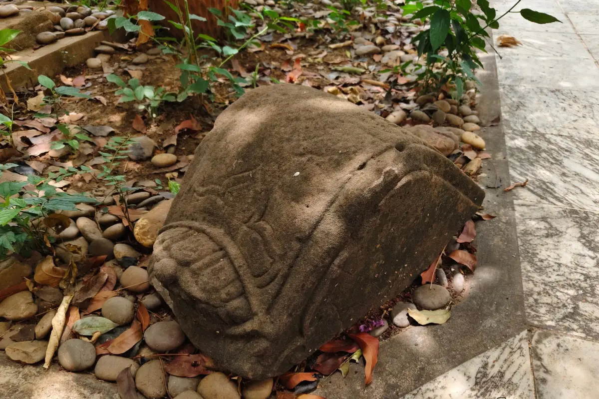
Ban Thu Archaeological Site is an important community-based archaeological landscape in That Phanom District, Nakhon Phanom Province. It occupies a settlement mound covering approximately 50 rai in Ban Thu, Nam Kam Subdistrict. Its most prominent remains are eight sandstone sema stones now preserved around the ordination hall of Wat Sa Phang Thong. Most are carved with a reliquary stupa shaped like a ritual water vessel, supported by an upward-facing lotus base and a beaded decorative band. Other discoveries include grinding stones, stone grinding slabs, hard-fired brown-glazed ceramic vessels associated with the Songkhram River kiln network, and large earthenware jars locally described as hai kha. Part of the archaeological collection is kept at Ban Thu Samakkhi Witthaya School. Together, the evidence indicates settlement, domestic activity, exchange, and Buddhist religious practice from approximately the 14th to the 21st Buddhist centuries.
The significance of Ban Thu does not depend on a monumental ruined temple, city wall, or palace. Its archaeological evidence is distributed through the living village, temple, school, roads, and settlement mound. Modern homes stand over or beside areas used by earlier generations. Visitors must therefore understand Ban Thu as an archaeological landscape rather than as a single display of sema stones. The elevation of the mound, the location of the temple, domestic artefacts, local memories, and surrounding waterways all contribute to the interpretation of the site.
Ban Thu lies in Nam Kam Subdistrict, a lowland region connected with the Nam Kam River and the Mekong. The environment offered water for drinking, agriculture, fishing, transport, and communication. The settlement mound provided raised ground above seasonally wet areas. Similar decisions can be observed at numerous archaeological settlements in northeastern Thailand, where communities occupied natural or gradually enlarged mounds close to rivers and wetlands.
The approximately 50-rai mound was not necessarily created through a single construction project. Long-term occupation gradually raised the surface as houses were rebuilt, ground levels were adjusted, refuse accumulated, and soil, ash, pottery, and construction material were deposited. Artefacts found close together can consequently belong to different centuries. The date range from the 14th to the 21st Buddhist centuries describes a long sequence of activity rather than one brief cultural phase.
This period corresponds approximately to the 8th–16th centuries CE, when the central Mekong basin and northeastern Thailand experienced several major cultural transitions. Communities absorbed Buddhist beliefs and artistic forms related to the Dvaravati world, maintained links with settlements across the Chi and Mun river systems, interacted with Khmer cultural and political networks, and later became part of the developing Lao and Lan Xang cultural sphere. Ban Thu should therefore be studied as a place of continuity and adaptation rather than assigned too narrowly to one kingdom.
The most important visible remains are the sandstone sema stones. They were originally found scattered across the village, and eight are now preserved around the ordination hall of Wat Sa Phang Thong. The terms sema and sima refer to boundaries associated with sacred Buddhist space and monastic ceremonies. Stone sema in northeastern Thailand, however, were not always used in exactly the same manner as boundary markers around modern ordination halls. They could surround ritual mounds, identify sacred places, mark ceremonial space, or function as objects of reverence.
The distribution of sema stones at Ban Thu demonstrates the existence of a Buddhist ritual area. They may once have defined a building or sacred zone whose architecture has disappeared. Early religious structures were often constructed from wood and other perishable materials, while sandstone markers survived. As the village and temple changed, local residents gathered the remaining stones around the present ordination hall, maintaining their association with Buddhist sacred space and protecting them from disappearance.
The stones were carved from sandstone, a material widely available across northeastern Thailand. Sandstone is strong enough to survive for centuries but can be shaped and engraved with appropriate tools. Craftsmen selected blocks without major fractures, trimmed them into upright slabs, prepared a lower section for setting into the ground, and carved the exposed surface. The process required technical knowledge, organised labour, and a clear understanding of religious symbolism.
Several stones display a stupa in the form of a ritual water vessel. The rounded central body resembles a pot or sacred container and stands above a decorated base. The stupa transformed the sema from a simple territorial marker into a symbolic representation of a sacred Buddhist monument. In Buddhist traditions, stupas preserve relics, commemorate the Buddha, and provide a focus for worship. A community could recognise the religious meaning of the image even without a written inscription.
The vessel-like form also relates to broader concepts of sacred containers, abundance, fertility, and the preservation of precious substances. Ritual pots appear in artistic traditions across South and Southeast Asia. When incorporated into a stupa image at Ban Thu, the shape expresses both Buddhist sanctity and the idea of a vessel holding spiritual value.
The lower section of several sema stones is carved with an upward-facing lotus base. Lotus petals support the stupa above them. The lotus is one of Buddhism's central symbols, representing purity, awakening, and the ability of spiritual understanding to arise from an imperfect world. Placing the stupa on a lotus base visually separates the sacred monument from ordinary ground.
A band of rounded forms resembling prayer beads appears above the lotus petals. The repeated pattern creates a visual division between the base and the stupa. It also demonstrates the craftsman's ability to control spacing and rhythm within a narrow stone surface. Although weathering has removed some details, the surviving decorative structure preserves the original design concept.
Some of the eight stones are undecorated. Their plain surfaces do not make them less important. Shape, material, dimensions, tool marks, weathering, and original position can all provide archaeological information. The variation may reflect different locations, functions, phases of production, or levels of completion. The group must be studied as a whole rather than judged only by the most elaborate carvings.
The present arrangement around the ordination hall protects the stones and makes them accessible, but it is not necessarily the complete original arrangement. Relocation can remove evidence concerning direction, spacing, depth, and relationships with former buildings. Even so, placing the stones in an active temple prevented them from being reused as building material, dispersed to private collections, or removed from the community.
Visitors should walk slowly around the ordination hall and first observe the general outline of every stone before concentrating on individual details. Height, thickness, surface texture, and weathering vary from one stone to another. The stupa is clear on certain examples but difficult to recognise on others. Angled morning or late-afternoon light often creates shadows that reveal carved lines more effectively than direct midday light.
The stones must not be rubbed, wetted, chalked, traced, or covered with paper for pencil rubbing. These actions loosen sandstone grains, introduce moisture, and accelerate surface loss. Careful observation, non-contact photography, and natural side lighting are safer. Researchers requiring detailed recording should obtain permission and use conservation-approved methods.
Ban Thu also produced grinding stones and grinding slabs, providing evidence of domestic production and food preparation. A handheld stone was moved across a larger working surface to crush grain, spices, medicinal plants, minerals, or other raw materials. Wear patterns can indicate movement and frequency of use. The tools confirm that Ban Thu was not solely a ceremonial site but a place where families prepared food and carried out everyday work.
If the stones were used to process grain, they relate to cultivation and food storage. If they processed pigment or mineral material, they may relate to craft activity. Function cannot be identified from shape alone; microscopic wear and residue analysis would provide stronger evidence. Nevertheless, the presence of grinding equipment firmly places daily household activity within the archaeological landscape.
Another important find is a hard-fired brown-glazed ceramic kendi or water vessel. Its narrow neck and container body made it suitable for holding liquids. High firing temperatures produced a dense ceramic fabric that absorbed less water than ordinary earthenware, while the brown glaze further reduced permeability and increased durability.
The glazed vessel has been associated with production traditions and kiln networks in the Songkhram River basin. An imported or regionally distributed vessel demonstrates that Ban Thu participated in exchange beyond the immediate village. The Nam Kam River linked inland communities with the Mekong, while the Mekong connected settlements in Nakhon Phanom, Sakon Nakhon, Mukdahan, and present-day Laos.
Such ceramics also extend the chronological range of the site into later historical periods. A vessel might remain in use for many years, be repaired, inherited, or stored as a valuable object. Archaeologists must compare form, clay fabric, glaze, firing technology, and find context rather than assigning every artefact the same date as the sema stones.
The collection also includes large earthenware containers known locally as hai kha. Large jars were essential in agricultural households for storing water, fermented food, grain, and other supplies. Their rims, shoulders, clay composition, and surface treatment can reveal manufacturing traditions and patterns of consumption.
The modern name hai kha should not be used by itself to assign an ethnic identity to the ancient makers or users. Object names can develop much later and may cover several ceramic forms. What the jars reliably demonstrate is that households maintained stored resources, preserved food or water, and used large containers as part of domestic organisation.
Grinding tools, glazed ceramics, and large jars are currently kept at Ban Thu Samakkhi Witthaya School. Keeping them near the original site allows local children to study the history of their own community. Teachers and residents connect archaeological objects with oral knowledge and local geography, turning the school collection into a community learning resource.
Anyone wishing to see the school collection should contact the school in advance and visit during official working hours. The school is an active educational environment, and visitors must not enter classrooms or open storage without permission. Prior coordination allows staff to arrange access and provide information without disrupting lessons or student safety.
Because the evidence is divided between temple, school, and village, stewardship is shared. Wat Sa Phang Thong and the community protect the sema stones. Ban Thu School cares for collected artefacts. Nam Kam Subdistrict Municipality can assist with local access, roads, and coordination. Sustainable conservation consequently depends on cooperation among monks, residents, teachers, students, municipal staff, archaeologists, and cultural heritage agencies.
Community participation is particularly important because Ban Thu is not enclosed by a protected archaeological park. Construction, road improvement, drainage work, and agricultural activity can expose pottery or other material. If residents encounter unusual concentrations of ceramics, charcoal, brick, bone, or stone objects, work should pause and the location should be documented. Objects must not be aggressively cleaned, sold, or separated from their findspot.
The mound and Buddhist remains suggest an organised settlement. Higher ground probably accommodated houses and religious activity, while lower areas supported agriculture, grazing, fishing, and access to water. A 50-rai mound provided space for households, shared buildings, paths, and community activity. The ancient settlement may nevertheless have extended beyond the visible mound, and its actual boundaries require archaeological survey.
The sema stones demonstrate the social importance of Buddhism. Producing large sandstone markers required quarrying or collecting rock, transport, shaping, carving, and installation. Such work required cooperation and leadership. The stones therefore represent not only belief but also the community's capacity to mobilise labour and create shared sacred space.
The stupa images show that religious ideas were communicated through visual symbols. Models could have travelled through monks, craftsmen, pilgrims, and exchange networks. Comparing Ban Thu with sema sites in Kalasin, Roi Et, Khon Kaen, Maha Sarakham, Sakon Nakhon, and other Mekong regions can help scholars study the movement of artistic forms and specialised craftsmen.
Although certain features relate to Dvaravati-period sema traditions, the site's long chronology continued through periods of Khmer influence and the emergence of Lan Xang culture. A stone created in one period may have remained sacred and been reused or reinterpreted in later centuries. Its present location within a functioning temple illustrates how an ancient object can change context while retaining religious value.
Wat Sa Phang Thong is consequently more than a storage location. It is where the past and present remain physically connected. The ordination hall continues to support Buddhist ceremonies, while ancient stones around it demonstrate the long religious history of the area. Visitors should wear appropriate clothing, speak quietly, respect ceremonies, and ask permission before photographing monks or residents at close range.
The community continues northeastern Buddhist traditions such as Bun Phawet, the merit-making festival associated with the Vessantara Jataka and the recitation of the Great Birth Sermon. Activities at Wat Sa Phang Thong demonstrate that the archaeological landscape remains a living religious centre. Festival dates follow the temple's annual calendar, and visitors should allow community worship to take priority over photography or archaeological observation.
Studying present traditions beside ancient evidence reveals continuity in the social role of the temple. Buildings, ceremonies, and monastic organisation have changed, but sacred space continues to bring households together. The communal labour required for present festivals echoes the cooperation that was necessary to produce and install the ancient sema stones.
A visit should begin at Wat Sa Phang Thong, where the remains are most visible. After entering the temple, locate the ordination hall and follow the permitted path around it. The eight stones may vary in visibility. Visitors must not cross restricted areas or move offerings, supports, or other objects placed near them.
The second area is the Ban Thu settlement mound. It should be viewed as an overall landform rather than searched for loose artefacts. Homes, roads, temple buildings, and the school occupy elevated ground above surrounding lowlands. Visitors must remain on public routes and should never enter private land to collect pottery.
The third area is Ban Thu Samakkhi Witthaya School. Access to the artefact collection requires permission. Visitors should follow staff instructions, avoid touching fragile pieces, and leave labels and registration numbers in place. An object that appears strong can still contain cracks or unstable surfaces.
The fourth area is the wider landscape connected with the Nam Kam River and the Mekong. Observing the surrounding floodplain explains why people selected the mound for settlement. Rivers provided food, transport, and communication. Travelling onward to Hat Hae or the mouth of the Nam Kam allows visitors to understand the environmental system supporting the community.
Ban Thu has no large visitor centre, ticket office, or permanent guide service. The recommended visiting period is between 08:00 and 17:00, when the temple can be viewed and local institutions can be contacted. Temple access is free. School collection access should always be arranged in advance.
Basic facilities are available in the temple, school, village, and nearby That Phanom town. Parking should be arranged in areas approved by the temple or community. Toilets may be available at the temple or nearby public facilities. Visitors should carry drinking water, sun protection, and personal supplies and must remove their rubbish.
Vehicles must not block the temple gate, houses, village roads, or the school entrance. The ground immediately around the ordination hall should not be used for turning vehicles. If a funeral, festival, ceremony, or school activity is taking place, visitors should avoid occupied areas and follow local directions.
Getting There from central That Phanom is straightforward by using local roads toward Nam Kam Subdistrict and Ban Thu. The journey is approximately 5 km and usually requires 10–15 minutes. Wat Sa Phang Thong, Ban Thu, or coordinates 16.912615, 104.711133 can be used as the destination. Because several minor roads enter the village, travellers should check current navigation information.
From Nakhon Phanom city, follow Highway 212 south toward That Phanom, then connect with the local road to Nam Kam Subdistrict. The distance is approximately 55 km and normally takes 50–70 minutes. Travellers approaching from Mukdahan can follow Highway 212 north toward That Phanom before entering the Ban Thu route.
Public transport stopping directly at Wat Sa Phang Thong is limited. Private car, rental vehicle, motorcycle, or locally hired transport is the most practical option. Travellers arriving by bus in That Phanom should arrange a local vehicle and agree on a return pickup. Providing the full village, subdistrict, and coordinates helps avoid confusion with other temples of the same name.
A general visit requires approximately 1–2 hours. Viewing only the sema stones may take 30–45 minutes, while a coordinated school visit and broader landscape observation require at least half a day. Morning offers cooler weather and side lighting that reveals carvings more clearly.
A half-day itinerary can combine Ban Thu, Wat Sa Phang Thong, the school collection when permission is granted, Wat Phra That Phanom Woramahawihan, and the learning or museum area associated with Phra That Phanom. The route connects a local Buddhist settlement with the major religious centre of the central Mekong.
A full-day itinerary can add Hat Hae at Ban Nam Kam and the Lower Nam Kam Water Gate. Moving from the archaeological mound to the Nam Kam River and the Mekong demonstrates how water, settlement, agriculture, fishing, transport, and religion formed an interconnected regional system.
Wat Phra That Phanom is approximately 5 km from Ban Thu and is one of northeastern Thailand's most important Buddhist monuments. The great stupa attracts worshippers from Thailand and Laos. Studying Ban Thu together with Phra That Phanom reveals that regional Buddhism consisted not only of a major pilgrimage centre but also of smaller settlement temples and sacred zones distributed across the landscape.
Hat Hae is a seasonal Mekong sandbar in Nam Kam Subdistrict. It is most prominent during low-water periods and may operate as a recreational area during the dry season. Visitors should check current water conditions and local announcements because the sandbar's size, access, and services change from year to year.
Most restaurants and accommodation are located in That Phanom town, a short drive from Ban Thu. Dining includes northeastern Thai food, fresh rice noodles, breakfast dishes, cafés, Thai cuisine, and Mekong riverside restaurants. Accommodation ranges from small resorts and budget rooms to riverfront hotels. During major Phra That Phanom festivals, advance reservations are strongly recommended.
Conserving sandstone sema requires attention to rain, moisture, vegetation, algae, and impact. Sandstone is porous and absorbs water. Repeated wetting and drying loosens surface grains. Cleaning chemicals and stiff brushes can remove carved details. Conservation treatment must be carried out by specialists using methods appropriate to each stone.
Outdoor display exposes the stones to sunlight, rain, dust, and pollution, but an improperly designed shelter could trap humidity or disrupt the temple setting. Management must consider drainage, nearby trees, foundation stability, and ceremonial use. Three-dimensional recording and regular condition photography would allow change to be monitored without repeated physical contact.
School-held artefacts require dry storage, stable shelves, labels, and records linking each object to its find information. Where original location is uncertain, the name of the finder, property, date, and local account should still be documented. A photographic inventory reduces the risk of loss and preserves information for future research.
The mound requires archaeological monitoring whenever major construction occurs. Foundations, drainage trenches, roadworks, or utility lines can cut through cultural deposits. Unusual soil layers, pottery concentrations, charcoal, bone, or brick alignments should be reported. Collecting only attractive objects while destroying their soil context eliminates essential chronological evidence.
Tourism at Ban Thu is best developed as small-scale educational visitation. School groups, university students, heritage travellers, and community-guided tours can create local pride and economic benefit without large construction. Intensive development or uncontrolled crowds could damage the mound and disrupt everyday village and temple life.
Oral history from elderly residents should be recorded, particularly accounts of original sema positions, pottery finds, grinding stones, and jars. Memory must be assessed alongside physical evidence, but it can guide future survey and explain the community's relationship with the objects. Local knowledge is therefore an essential component of community archaeology.
Ban Thu School plays a central role in transmitting this knowledge. Students can map the mound, interview residents, draw sema carvings, study pottery, and document village change. These activities show that archaeology is not an isolated academic subject but evidence of ancestors and a resource for community identity.
The site also contributes to research on ancient settlements around Si Khotrabun and Phra That Phanom. The evidence is not sufficient to describe Ban Thu as a political capital or fortified city, but its location, Buddhist stones, and long ceramic sequence place it firmly within significant cultural networks of the Mekong basin.
The absence of walls or stone architecture does not reduce its importance. Most people in the past lived in wooden houses, worked in fields, gathered in open spaces, and worshipped in buildings made from perishable materials. Pottery fragments, tools, settlement surfaces, and ritual stones often reveal daily life more clearly than a single monumental structure.
Visitors should pause before each sema and consider the work required to produce it: selecting sandstone, transporting the block, shaping the slab, carving the image, and installing it through communal effort. The stupa images preserve faith and artistic skill, while weathering reminds visitors that every object has a finite physical life.
Walking from the temple to the school changes the setting from sacred space to education, but the archaeological narrative remains continuous. The sema stones represent belief, grinding tools represent food and labour, and ceramic vessels represent storage, technology, and exchange. Together, they reconstruct a community with spiritual, domestic, and economic dimensions.
Ban Thu is suitable for travellers interested in northeastern Thai culture, Dvaravati-related sema traditions, Mekong history, and community-held heritage. It has no extensive museum exhibition, but offers a close encounter with objects maintained within their home village. Much of Thailand's heritage survives in temples, schools, and settlements rather than only in national museums.
The site's greatest value is continuity. The mound remains inhabited, the ancient stones remain beside an active ordination hall, domestic artefacts educate local children, and festivals continue to bring residents together. Protecting Ban Thu does not require removing archaeology from community life. It requires allowing contemporary use while preventing the destruction of evidence from earlier generations.
A responsible visit includes respectful behaviour in the temple, advance coordination with the school, observation of the mound without trespassing, and strict non-contact treatment of artefacts. Visitors assist conservation by removing rubbish, avoiding damage, and sharing accurate information. When the site is understood and valued, the community gains stronger support for preserving the sema stones and archaeological collection for future generations.
| Name | Ban Thu Archaeological Site |
| Location | Ban Thu, Nam Kam Subdistrict, That Phanom District, Nakhon Phanom Province |
| Address | Ban Thu, Village No. 6, including Wat Sa Phang Thong, Nam Kam Subdistrict, That Phanom District, Nakhon Phanom 48110, Thailand |
| Coordinates | 16.912615, 104.711133 |
| Site Character | An archaeological settlement mound covering approximately 50 rai within the Nam Kam and Mekong river landscape |
| Highlights | Eight sandstone sema stones, several carved with vessel-shaped stupas above lotus and beaded bases, preserved around Wat Sa Phang Thong's ordination hall |
| Approximate Period | 14th–21st Buddhist centuries, approximately the 8th–16th centuries CE |
| Key Evidence | Sandstone sema stones, grinding stones, grinding slabs, hard-fired brown-glazed ceramics associated with the Songkhram basin kiln network, and large hai kha earthenware jars |
| Evidence Locations | Sema stones are around the ordination hall at Wat Sa Phang Thong; grinding equipment and ceramic vessels are held at Ban Thu Samakkhi Witthaya School |
| Importance | Evidence of settlement, Buddhist ritual, domestic production, ceramic technology, and regional exchange in the central Mekong basin across several historical periods |
| Current Status | A living community archaeological landscape with sema protected in the temple and part of the artefact collection held in the local school |
| Open Days | Daily |
| Opening Hours | 08:00–17:00; access to school-held artefacts must be arranged in advance during official working hours |
| Fees | Free admission |
| Facilities | Parking within temple or community areas, toilets at the temple or nearby public facilities, and basic shops and services in the village and That Phanom town |
| Main Areas | 1. Wat Sa Phang Thong ordination hall and sema stones 2. Ban Thu settlement mound 3. Ban Thu School archaeological collection 4. Village and surrounding lowland landscape 5. Route connecting the Nam Kam River and Mekong |
| Living Tradition | Bun Phawet and other Buddhist merit-making activities at Wat Sa Phang Thong; dates follow the temple's annual calendar |
| Visitor Guidelines | Dress respectfully, do not touch or wet the sema stones, do not mark or move artefacts, remain off private land, and contact the school before viewing its collection |
| Travel Information | Approximately 5 km from central That Phanom by local road through Nam Kam Subdistrict; approximately 55 km from Nakhon Phanom city via Highway 212 |
| Caretakers and Coordinators | Wat Sa Phang Thong, Ban Thu community, Ban Thu Samakkhi Witthaya School, and Nam Kam Subdistrict Municipality. The school collection is coordinated by School Director Apisit Arakanit. |
| Main Contact Numbers | Nam Kam Subdistrict Municipality: 042-059285 Ban Thu Samakkhi Witthaya School: 083-489-2047 |
| Official Websites | Nam Kam Subdistrict Municipality: https://www.namkamlocal.go.th/ Ban Thu School: https://bantoo.ac.th/ |
| Nearby Tourist Attractions | 1. Wat Sa Phang Thong and Ancient Sema Stones, 0 km 2. Ban Thu School Archaeological Learning Collection, 1 km 3. Wat Phra That Phanom Woramahawihan, 5 km 4. Phra That Phanom Historical Learning and Museum Area, 5 km 5. Hat Hae at Ban Nam Kam, 7 km 6. Lower Nam Kam Water Gate, Thoranit Naruemit, 9 km |
| Nearby Restaurants | 1. Sister That Phanom, 5 km, Tel. 042-532148 2. Kafae Nai Suan That Phanom, 6 km, Tel. 099-236-9294 3. Phoem Phun Fresh Rice Noodles, 6 km, Tel. 086-192-8845 4. Nong Bam Khao Pun Nam Nua, Ban Tong, 7 km, Tel. 089-080-1460 5. Krua Rim Khong View That Phanom, 7 km, Tel. 063-428-9415 |
| Nearby Accommodations | 1. Na That Phanom Place, 5 km, Tel. 081-504-7899 or 042-532149 2. Sawasdee Resort That Phanom, 5 km, Tel. 095-225-5591 or 085-881-9905 3. That Phanom River View Hotel, 6 km, Tel. 089-967-7282 4. Thatphanom View Hotel, 6 km, Tel. 062-479-5558 5. Hug Home Resort That Phanom, 6 km, Tel. 063-043-9855 |
Frequently Asked Questions (FAQ)
Q: Where is Ban Thu Archaeological Site?
A: The site is in Ban Thu, Nam Kam Subdistrict, That Phanom District, Nakhon Phanom Province. The principal sema stones are around Wat Sa Phang Thong's ordination hall at coordinates 16.912615, 104.711133.
Q: What are the opening hours of Ban Thu Archaeological Site?
A: The temple and community area can be visited daily between 08:00 and 17:00. Access to artefacts kept at Ban Thu School must be arranged in advance during official working hours.
Q: Is there an admission fee?
A: Admission is free. Visitors must respect the active temple, school, and residential community and must not touch or move archaeological material.
Q: What is distinctive about the Ban Thu sema stones?
A: Eight sandstone sema stones remain. Several are carved with a vessel-shaped stupa supported by an upward-facing lotus base and a beaded decorative band, while some examples are undecorated.
Q: How old is the archaeological evidence at Ban Thu?
A: The evidence covers approximately the 14th–21st Buddhist centuries, corresponding broadly to the 8th–16th centuries CE. Individual objects may belong to different phases within this long period.
Q: Where are the other artefacts kept?
A: Grinding stones, grinding slabs, brown-glazed hard-fired ceramics, and large jars are kept at Ban Thu Samakkhi Witthaya School. Visitors should contact the school before requesting access.
Q: Can visitors touch or pour water on the sema stones?
A: No. Touching, rubbing, wetting, chalking, and tracing damage the sandstone surface. Visitors should use natural side lighting and non-contact photography.
Q: Which nearby places can be combined with Ban Thu?
A: A visit can be combined with Wat Phra That Phanom, the Phra That Phanom learning area, Hat Hae at Ban Nam Kam, and the Lower Nam Kam Water Gate.
 Category: ●Art, Culture and Heritage
 Group: ●Historical Sites and Monuments
Last Update : 2 WeekAgo
 Last Update : 2 WeekAgo
 Click to Access the Navigation Map GPS
Ban Thu Archaeological Site Map
Recommend
 Historical Sites and Monuments(3)
 Landmarks and Memorials(2)
 Art, Craft Centres, Tradition(3)
 Museums(3)
 Educational Places
 Library(1)
 Places of Worship
 Temple(23)
 Church(1)
 Other Sacred Sites(11)
 Suburban Living
 Village, Community(5)
 Nature and Wildlife
 National Parks and Marine Reserves(1)
 Dam, Reservoir, Lake(5)
 Waterfalls(2)
 River, Canal(3)
 Bays and Beaches(3)
 Other natural attractions(2)
 Entertainment and Agricultural
 Zoos and Aquariums(1)
 Farms, Parks and Ecotourism(2)
 Shopping
 Shopping and Night Market(1)
 Travel Articles, Recipes
 Travel Review, Food Review(1)


