
lovethailand home >Northeastern Travel Attractions >Nakhon Phanom Travel Attractions >Muang Nakhon Phanom >Nai Muang > Si Khotrabun Golden Sand Beach and Public Park
TL;DR: Si Khotrabun Golden Sand Beach and Public Park, Nakhon Phanom attractions : Entertainment and Agricultural, Farms, Parks and Ecotourism.
Si Khotrabun Golden Sand Beach and Public Park
Open Days: Daily
Opening Hours: 06:00–20:00. Access to the seasonal sandbar depends on the Mekong water level, weather conditions, daylight, and local safety notices.
Admission Fee: Free admission
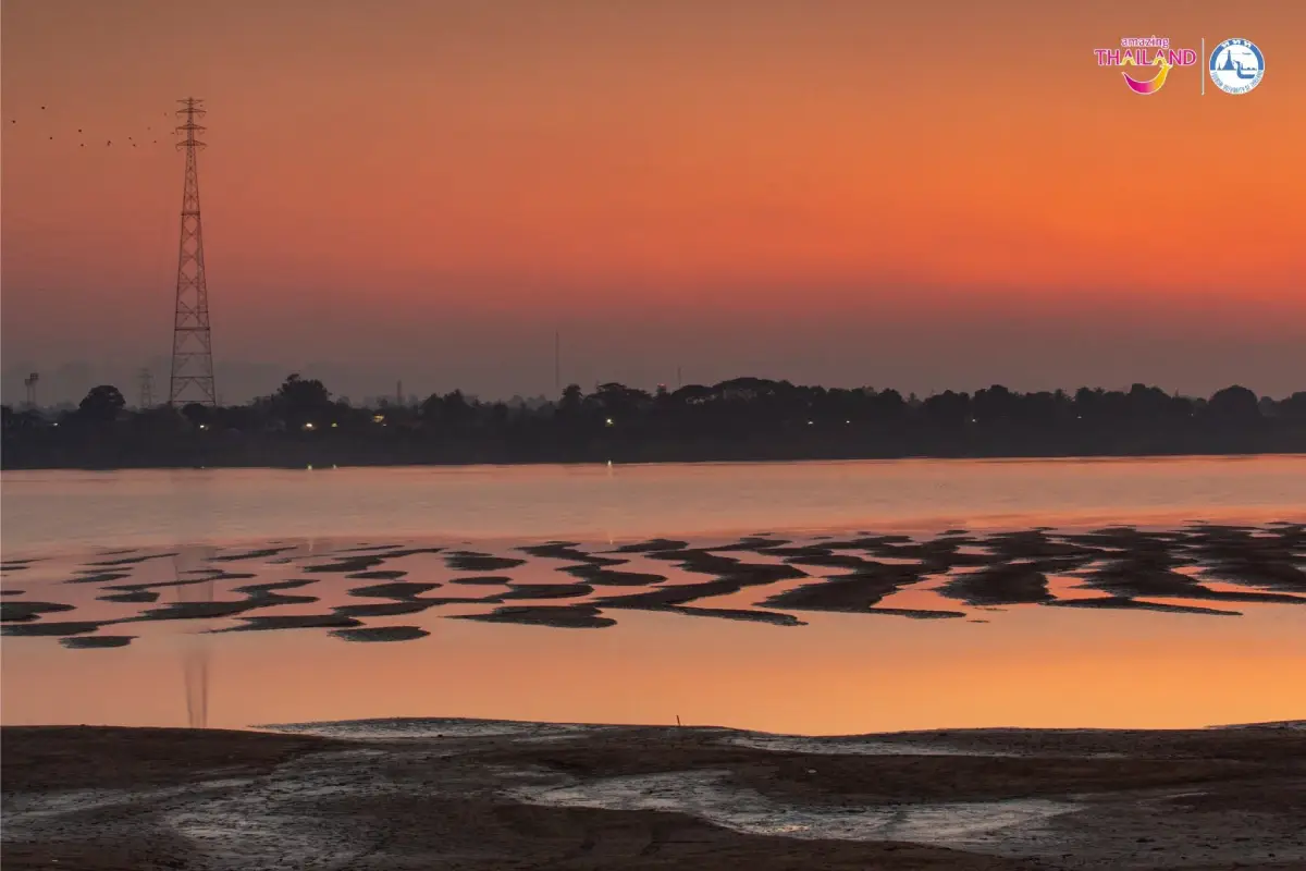
Si Khotrabun Golden Sand Beach and Public Park in Nakhon Phanom is one of northeastern Thailand’s most distinctive seasonal river landscapes. Rather than being a permanent beach, it is a natural freshwater sandbar revealed when the Mekong River falls during the dry season. The broadest and most visible stretches of sand usually appear between February and May, although the exact timing, size, and shape vary each year according to rainfall, upstream water conditions, sediment movement, and the river’s current. Visitors who arrive at the right time can see golden sand extending from the Thai riverbank toward the middle of the Mekong, naturally sculpted ripple patterns, views across to Thakhek and Khammouane Province in Laos, and sunrise light spreading over the river from the Lao side.
The attraction is more than a seasonal sandbar. It forms part of Nakhon Phanom’s riverside public space, where local residents walk, run, cycle, relax, meet friends, and enjoy the river breeze. Early mornings bring joggers, cyclists, photographers, and visitors waiting for the first light of the day. In the evening, families and travelers return to the promenade to enjoy cooler temperatures, watch the sky change color, and see the lights of Thailand and Laos gradually appear on opposite banks of the Mekong.
The beach and public park are located along Sunthon Wichit Road in Nai Mueang Subdistrict, Mueang Nakhon Phanom District, Nakhon Phanom Province. The approximate coordinates are 17.416356, 104.780180. The site faces Thakhek and the administrative center of Khammouane Province in the Lao People’s Democratic Republic. On a clear day, visitors can see Lao buildings, riverside communities, distant hills, and everyday activity on the opposite bank. This cross-border setting gives the park a character unlike an ordinary urban green space: a single view brings together an international river, two countries, two cities, and the shared way of life of communities along the Mekong.
The name “Si Khotrabun,” also written as “Sri Khotrabun” or “Si Khotrabun,” is associated with the historical identity of an ancient polity and communities in the central Mekong basin. Nakhon Phanom’s history developed through settlements on both sides of the river, connected by trade, religion, migration, and culture. Using the historical name for the sandbar links the natural landscape with the region’s deeper past and reinforces Nakhon Phanom’s identity as a Mekong city shaped by cross-border relationships over many generations.
The sandbar is created through the river’s annual cycle. During the rainy season, the Mekong carries water, sand, soil, organic material, and minerals from a vast upstream catchment. When the flow weakens and the water level falls during the dry season, some of this sediment settles in areas where the current slows, creating exposed ridges and broad sandy surfaces. In one year, the sandbar may appear as a continuous stretch; in another, it may be divided by shallow channels, soft mud, or isolated pools. Its form is never guaranteed to match photographs taken in a previous season.
One of the most photogenic features is the network of small ripples formed by water and wind. Local observers sometimes compare these patterns to the scales of a naga, frozen waves, or fabric drawn with flowing lines. Water left between the ridges reflects the sky, creating layers of gold, blue, silver, and orange. At sunrise, warm light arrives from the Lao side and reveals the texture of the sand, making the area particularly suitable for wide landscapes, silhouettes, close-up details, and compositions that include boats or the distant city of Thakhek.
Despite being called a beach, Si Khotrabun differs fundamentally from a seaside destination. It is a temporary freshwater sandbar, without permanent beach facilities or predictable sea-like waves. The Mekong’s current can change quickly, shallow-looking water may conceal deep channels, and damp sand can become unstable. Visitors should treat the site as a natural observation and walking area rather than an officially designated swimming beach. Swimming, walking into channels, or allowing children to approach the river unattended is not recommended.
The most reliable season for seeing the sandbar generally extends from late winter into the hot season, roughly February through May. In February, the exposed area may still be relatively narrow, but temperatures are usually more comfortable for walking. By March and April, lower water levels often reveal a larger sandy landscape. These months can also be extremely hot, particularly from late morning to mid-afternoon. Visitors should therefore come around sunrise or in the late afternoon, carry drinking water, wear sun protection, and avoid walking barefoot on hot sand.
From approximately June to October, the rainy season raises the Mekong and normally covers most or all of the seasonal sandbar. The public park remains useful for riverside walks and scenic views, but travelers should not arrive expecting the expansive golden beach seen in dry-season photographs. In July, the river is generally fuller, surrounding vegetation is greener, and clouds are more frequent. The experience changes from exploring sand to observing the power and scale of the Mekong. Flood notices, heavy-rain warnings, and temporary restrictions near the riverbank should always be followed.
November through January is a transitional period. The river normally begins to recede, but it may not yet be low enough to reveal a broad sandbar. In some years, small areas emerge unusually early, while in others the main beach does not become visible until February. Rainfall patterns and upstream water management contribute to this variation. The “sandbar season” should therefore be treated as an approximate window rather than a fixed annual schedule.
The best daily visiting periods are approximately 06:00–08:00 and 16:30–19:00. Morning visitors can watch the sun rise over Laos, enjoy cooler temperatures, and observe local exercise routines. Evenings are ideal for relaxed walks and riverside dining after the heat has subsided. Although sunset occurs toward the Thai side rather than directly over Laos, reflected evening light still produces attractive colors across the water and sand. Low-angle light is particularly useful for photography because it emphasizes the shadows between the natural ridges.
The riverside public park is the primary year-round viewing area. Even when sandbar access is impossible, travelers can observe the Mekong, Laos, passing boats, and changing weather from the promenade. The park is connected to Sunthon Wichit Road and Nakhon Phanom’s historic riverside district. It can be incorporated into a walking route beginning at the Former Nakhon Phanom Governor’s Residence Museum and continuing toward Nakhon Phanom Walking Street, the Phaya Si Sattanakharat Monument, Wat Mahathat, and other attractions in the town center.
The first functional area is the riverside promenade and public park, used for walking, jogging, cycling, sitting, and sightseeing. This is the easiest part of the attraction to access and does not depend on the sandbar’s seasonal appearance. Travelers with limited time can stop for 30–45 minutes, while those exploring the wider old town may spend several hours following the riverfront route.
The upper sandbar viewpoint is suitable for older travelers, families with young children, and visitors who prefer not to walk across uneven sand. From this raised area, the shape of the sandbar and the changing river level can be observed at a safer distance. It is also a convenient sunrise photography position. Wheelchair users should remain on smooth sections of the promenade and avoid steep slopes, riverbank edges, or informal access paths.
The seasonal access area to the sandbar can be used only when the river has receded, the surface is sufficiently dry, and no barriers or warning notices prohibit entry. The safest access point may change every year as sediment shifts and the riverbank erodes or rebuilds. Visitors should not create new paths, cross muddy ground, climb over barriers, or follow isolated footprints into uncertain terrain. If the sand begins to sink, water rapidly fills footprints, or a channel blocks the return route, visitors should immediately turn back.
The sunrise and photography area is not formally separated by barriers, but open viewpoints facing east are the most popular. Photographers should arrive 20–30 minutes before sunrise to inspect the terrain in safe light. Wide-angle lenses are useful for the sandbar and sky, while medium or telephoto lenses can isolate fishing boats, Lao architecture, and distant hills. Tripods should never block the promenade, and equipment should not be left close to the water unattended.
The exercise and community activity area follows the riverside promenade. Mornings and evenings are lively without feeling excessively crowded. Visitors will see regular joggers, older residents enjoying the breeze, families, cyclists, and tourists exploring the town. Certain sections may occasionally host municipal events, cultural displays, Songkran activities, or sand-related exhibitions. These events are seasonal and not guaranteed every year, so current municipal announcements should be checked before planning a visit around a specific program.
Facilities are those of an urban riverside park rather than a permanent beach resort. They include a promenade, public seating, exercise routes, urban lighting, and parking at permitted roadside or nearby locations. There are no permanent visitor facilities on the seasonal sandbar itself. Travelers should use restrooms, purchase drinks, and organize belongings in town before walking onto the sand. Carry only essential items and remove all rubbish when leaving.
The public space is managed by Nakhon Phanom Town Municipality. For information about riverside access, public events, or temporary changes, the municipality can be contacted at +66 42 512 005. General tourism information is available from the Nakhon Phanom Provincial Office of Tourism and Sports at +66 42 516 337. Contacting the relevant office is particularly useful during the rainy season, major festivals, or visits by large groups.
Families should plan according to the age and mobility of their children. Young children can enjoy the park under close supervision, but they should not run down informal slopes or approach river channels. Adults should explain that the sandbar is a changing natural environment rather than a playground. Closed-toe or secure sports shoes are more practical than loose sandals on damp sand. Drinking water, a small towel, and spare clothing for children can make the visit more comfortable.
Older travelers and people with limited mobility can enjoy the view from the public promenade without descending to the sandbar. Walking on loose sand requires more strength and balance, especially on damp surfaces or slopes. The upper viewpoint is safer and still provides a complete panorama. Wheelchair users should visit during quieter periods, remain on level paths, and have a companion inspect the route in advance.
Anyone walking on the sandbar should continuously monitor the water. The Mekong can rise because of rainfall far upstream even when the weather in Nakhon Phanom is dry. If water begins filling the channels, the route back becomes narrower, or officials instruct people to leave, visitors must return to the riverbank immediately. Do not walk so far that the access point is no longer clearly visible, and never attempt to cross toward Laos. The international boundary follows the river, and deep navigational channels remain between the two countries.
Swimming is not recommended. A calm surface does not indicate that underwater currents are weak, and the riverbed can drop suddenly. Sand and channels move over time, so an area considered shallow during one season may be dangerous in another. Visitors should remain on dry ground and use the location primarily for walking, photography, and nature observation.
Keeping the area clean is essential for both the city and the Mekong ecosystem. Plastic bags, food containers, straws, and foam packaging can easily be blown or washed into the river. Visitors should avoid carrying unnecessary packaging onto the sandbar, remove every item of rubbish, and never bury food waste in the sand. Sand, aquatic plants, shells, and small organisms should not be taken away as souvenirs, as they are part of the natural riverbank environment.
Drone operation requires careful attention to aviation law, privacy, border restrictions, and local regulations. Because the park faces Laos and lies beside an international boundary, drones must not cross the river or enter Lao airspace without authorization. Registration, restricted airspace, and local permission should be checked before any flight. Conventional photography from the public park is simpler and avoids unnecessary legal risk.
Lightweight, breathable clothing and sun protection are appropriate for most of the year. Secure shoes with good grip are preferable to smooth-soled footwear. During cool-season mornings, a light jacket may be useful because the river breeze can feel cooler than central town streets. During the hot season, visitors should carry a hat, sunglasses, sunscreen, and sufficient drinking water. Camera equipment should be protected from blowing sand, and lenses should not be changed in exposed windy conditions.
A general visit to the park and viewpoint takes approximately 45–90 minutes. When the sandbar is exposed and visitors wish to walk, photograph the landscape, or wait for sunrise, 2–3 hours is more suitable. Travelers exploring the historical riverside district can spend half a day combining the beach with the Former Governor’s Residence Museum, St. Anna Nong Saeng Co-Cathedral, the walking street, riverside monuments, and temples.
Getting there from central Nakhon Phanom is straightforward because the attraction lies within the city along Sunthon Wichit Road. Guests staying near the Mekong can often walk or cycle, while local taxis and ride services provide convenient access from other neighborhoods. When using digital maps, search for “หาดทรายทองศรีโคตรบูรณ์,” “หาดทรายทองศรีโคตรบูร,” or “Si Khotrabun Golden Sand Beach,” and confirm that the pin is beside the Former Nakhon Phanom Governor’s Residence Museum.
Drivers can reach Sunthon Wichit Road through central city streets and park only in designated roadside or nearby areas. Do not obstruct homes, government buildings, bicycle routes, or emergency access. Parking may become limited during weekends and special riverside events. Leaving the vehicle slightly farther away and walking through the historic district is often more convenient and provides a better view of traditional buildings and local life.
Nakhon Phanom Airport is approximately 17 kilometers from the central riverside area, with a normal journey of about 25–30 minutes depending on traffic. Rental cars, taxis, and prearranged transfers are available. Travelers arriving in the morning can leave luggage at their hotel and visit the park later in the day. Those departing on an early flight should avoid scheduling a sunrise visit unless sufficient transfer time has been allowed.
From Nakhon Phanom Bus Terminal, a local taxi or ride service can take travelers to Sunthon Wichit Road. Visitors traveling before sunrise or late in the evening should arrange a return journey in advance because fewer vehicles may be available. The Former Governor’s Residence Museum and Sunthon Wichit Road are useful landmarks to show a driver.
A morning itinerary can begin at approximately 05:45, allowing time to find a safe viewpoint before sunrise. After photographing the river and walking on the exposed sandbar when permitted, visitors can have breakfast in town and continue to the Former Governor’s Residence Museum, St. Anna Nong Saeng Co-Cathedral, the clock tower district, and other riverside heritage sites. This schedule is particularly suitable for photographers and travelers who prefer cooler temperatures.
An evening visit can begin around 16:30 with a walk through the park and a view of the seasonal sandbar from above. Visitors may then continue to the Phaya Si Sattanakharat Monument and enjoy dinner at a riverside restaurant. When Nakhon Phanom Walking Street is operating, the evening can end with local food, crafts, and community products. Current walking-street dates and municipal event schedules should be confirmed before travel.
A full-day route can begin at Si Khotrabun Golden Sand Beach, continue through the historic town, and include lunch before traveling to the Ho Chi Minh Memorial at Ban Na Chok or the Nong Yat Freshwater Aquarium. Returning to the Mekong riverfront in the evening provides a complete introduction to Nakhon Phanom’s natural environment, history, religious diversity, cross-border connections, and contemporary city life.
Restaurants near the park range from Isan and Vietnamese cuisine to Thai food, cafés, hotel dining, and riverside venues. Nearby choices include River Bar at Fortune River View Hotel, Sabaidee @ Nakhon Phanom, Ban Namphon Restaurant, Ban Pa Nakhon Phanom, and The Tree Cafe & Restaurant. Opening hours can change, particularly during holidays and festivals, so direct confirmation is recommended.
Riverside and city-center hotels are convenient for sunrise visits because guests can reach the park without a long early-morning transfer. Nearby properties include Fortune River View Hotel Nakhon Phanom, Siri Regent Hotel, Mekong Heritage Hotel, VELA Dhi Nakhon Phanom, and Landmark Nakhon Phanom. Accommodation should be reserved well in advance during the Illuminated Boat Procession Festival, long weekends, and major public holidays, when river-view rooms are especially popular.
The sandbar and riverfront may occasionally become part of municipal programs such as sand sculpture displays, cultural events, Songkran celebrations, or tourism activities. These are not permanent attractions and depend on water levels, local policy, and annual planning. Travelers should never assume that a previous year’s event will be repeated on the same dates.
Ecologically, exposed sandbars are transitional habitats between water and land. They may provide temporary resting areas for birds, support small organisms, and collect natural organic material. Tire tracks, digging, litter, and disturbance can damage these seemingly empty surfaces. Visitors should remain in appropriate areas, avoid chasing wildlife, and never drive vehicles onto the sand.
The beach is also an effective outdoor classroom. Students can observe changes in river level, sediment deposition, ripple formation, seasonal geography, and the relationship between the Mekong and local communities. Parents and teachers can compare dry-season photographs with rainy-season conditions, explain why the sandbar appears and disappears, and connect the experience to water use, conservation, climate, and international rivers.
The view from the park demonstrates how deeply Nakhon Phanom is connected to the Mekong. The river has served as a route of travel, a food source, an international border, a cultural landscape, and the setting for everyday life. Historic homes, temples, churches, markets, and neighborhoods developed along the water. Looking across to Thakhek is therefore more than sightseeing; it reveals a region whose people share long histories of language, food, belief, and movement.
History enthusiasts should visit the Former Nakhon Phanom Governor’s Residence Museum immediately beside the park. Its architecture and exhibitions help explain the development of modern Nakhon Phanom. Continuing to St. Anna Nong Saeng Co-Cathedral introduces the history of the local Catholic community and one of the province’s most distinctive religious landmarks. Together, these attractions provide historical context for the riverside landscape.
The Phaya Si Sattanakharat Monument is another easy extension. Naga traditions are central to the beliefs and artistic heritage of Mekong communities. The rippled sand is sometimes compared with naga scales, linking natural forms with local imagination. Scientifically, the patterns result from water and wind, while culturally they evoke stories associated with the river. Both interpretations can be appreciated together.
The cool season is generally the most comfortable time for walking, with pleasant mornings, open skies, and a refreshing river breeze, although the sandbar may not yet be fully exposed. The hot season provides the best chance of seeing a broad beach but requires serious heat precautions. The rainy season presents the Mekong at its fullest and greenest but is unsuitable for sandbar access. Choosing a travel period depends on whether the priority is exposed sand, cooler weather, or the dramatic high-water landscape.
Before leaving accommodation, visitors should check the weather forecast, water conditions, and municipal notices. During thunderstorms, strong winds, or rapidly rising water, remain on the upper promenade. Phones should be fully charged, and solo photographers visiting before sunrise should tell a companion where they will be. A small flashlight can help identify uneven surfaces without disturbing other visitors.
For first-time visitors, Si Khotrabun Golden Sand Beach offers an immediate introduction to Nakhon Phanom. From one location, travelers can see an international river, another country, historic neighborhoods, community recreation, and a changing natural landscape. Beginning a journey here makes the geography of the city easier to understand and provides a logical starting point for exploring the Mekong riverfront.
Returning in a different season reveals how dynamic the river is. A surface walked across in April may be completely underwater in July, channels may move, and the color and speed of the Mekong may change. These differences demonstrate that the river is a living natural system rather than a fixed backdrop. Observing the same place at different times provides a deeper experience than a single photographic visit.
The current public park remains accessible for normal riverside use, while the visibility and accessibility of the sandbar are seasonal. During July, which falls within the rainy season, travelers should not expect the expansive dry-season beach normally photographed in March or April. Anyone visiting specifically for the sandbar should plan for February through May and check recent images or official notices before departure.
A meaningful visit does not require constant activity. Walking slowly, observing the ripples, listening to the river, watching boats, and understanding how the landscape is rebuilt each year can be more rewarding than rushing to the next photo stop. The site encourages visitors to appreciate both the scale of the Mekong and small details formed by water, wind, and sediment.
Si Khotrabun Golden Sand Beach and Public Park combines a seasonal freshwater landscape, international Mekong views, local history, cross-border culture, community life, and urban recreation. During the dry season, the golden sandbar creates one of Nakhon Phanom’s most memorable natural scenes. At other times, the park remains a valuable place to experience the river and historic town. Respecting safety notices, avoiding damage to the sandbar, removing rubbish, and protecting the riverside environment will help preserve this shared public place for residents and future travelers.
| Name | Si Khotrabun Golden Sand Beach and Public Park |
| Thai Name | สวนสาธารณะและหาดทรายทองศรีโคตรบูรณ์ |
| Location | Sunthon Wichit Road, Nai Mueang Subdistrict, Mueang Nakhon Phanom District, Nakhon Phanom Province, Thailand |
| Coordinates | 17.416356, 104.780180 |
| Characteristics | A Mekong riverside public park and seasonal freshwater sandbar revealed when the river falls during the dry season, with views toward Thakhek and Khammouane Province in Laos |
| Highlights | Golden sand, natural ripple formations, sunrise over Laos, cross-border Mekong scenery, photography, walking, cycling, and community recreation |
| Name Origin | The name refers to the historical identity of Si Khotrabun, associated with ancient settlements and political communities in the central Mekong basin and the history of Nakhon Phanom |
| Best Sandbar Season | Approximately February–May, depending on the Mekong water level and river conditions each year |
| Best Time of Day | 06:00–08:00 for sunrise and 16:30–19:00 for evening walks and photography |
| Main Areas / Zones | 1. Riverside Promenade and Public Park 2. Upper Sandbar Viewpoint 3. Seasonal Sandbar Access Area 4. Sunrise and Photography Area 5. Exercise and Community Activity Area |
| Facilities | Riverside promenade, public seating, exercise route, urban lighting, and parking at permitted roadside or nearby locations |
| Management | Nakhon Phanom Town Municipality |
| Open Days | Daily |
| Opening Hours | 06:00–20:00. Sandbar access depends on the water level, weather, daylight, and local safety notices. |
| Admission Fee | Free admission |
| Recommended Duration | 45–90 minutes for general sightseeing or 2–3 hours for sandbar walking and photography |
| Travel Information | Located in central Nakhon Phanom along Sunthon Wichit Road and accessible by car, local taxi, bicycle, or on foot from riverside hotels and attractions |
| Current Status | The public park is open for normal use. The sandbar is seasonal and may be completely covered during the rainy season. |
| Main Contact Numbers | Nakhon Phanom Town Municipality: +66 42 512 005 Nakhon Phanom Provincial Office of Tourism and Sports: +66 42 516 337 |
| Official Management Website | www.nakonphanomcity.go.th |
| Nearby Tourist Attractions | 1. Former Nakhon Phanom Governor’s Residence Museum, approximately 0.1 km; Nakhon Phanom Provincial Office: +66 42 511 574 2. Nakhon Phanom Walking Street, approximately 1 km; Municipality Information: +66 42 512 005 3. St. Anna Nong Saeng Co-Cathedral, approximately 1 km; Tourism Information: +66 42 516 337 4. Phaya Si Sattanakharat Monument, approximately 1.5 km; Municipality Information: +66 42 512 005 5. Wat Mahathat and Phra That Nakhon, approximately 3 km; Tourism Information: +66 42 516 337 |
| Nearby Restaurants | 1. River Bar at Fortune River View Hotel, approximately 0.7 km, Tel. +66 42 522 334 2. Sabaidee @ Nakhon Phanom, approximately 1 km, Tel. +66 42 064 200 3. Ban Namphon Restaurant, approximately 1 km, Tel. +66 90 904 4999 4. Ban Pa Nakhon Phanom, approximately 2 km, Tel. +66 83 026 9297 5. The Tree Cafe & Restaurant, approximately 4 km, Tel. +66 80 892 9082 |
| Nearby Accommodations | 1. Fortune River View Hotel Nakhon Phanom, approximately 0.7 km, Tel. +66 42 522 334 2. Siri Regent Hotel Nakhon Phanom, approximately 1 km, Tel. +66 61 934 9900 or +66 42 513 777 3. Landmark Nakhon Phanom, approximately 1 km, Tel. +66 91 740 3001 4. Mekong Heritage Hotel, approximately 2 km, Tel. +66 42 511 189 or +66 88 755 0215 5. VELA Dhi Nakhon Phanom, approximately 2 km, Tel. +66 42 515 919 |
Frequently Asked Questions (FAQ)
Q: Is Si Khotrabun Golden Sand Beach open throughout the year?
A: The riverside public park is open daily, but the exposed sandbar appears only when the Mekong River falls. It is normally most visible between approximately February and May.
Q: Which month is best for seeing the largest sandbar?
A: March and April often provide the best opportunity, although the river level varies each year. Recent photographs and official water information should be checked before travel.
Q: Is there an admission fee?
A: No. The park and seasonal sandbar can be visited free of charge.
Q: Can visitors swim in the Mekong beside the sandbar?
A: Swimming is not recommended because of currents, deep channels, and changing riverbed conditions. The area is better used for walking, sightseeing, and photography.
Q: What is the best time for photography?
A: Approximately 06:00–08:00 is best for sunrise over Laos, while 16:30–19:00 provides cooler conditions and attractive evening light.
Q: Is the attraction suitable for children and older travelers?
A: The public park is suitable for all ages. Children require close supervision, and older travelers are advised to remain on the upper promenade rather than walking across loose or damp sand.
Q: Is parking available nearby?
A: Parking is available at permitted roadside and nearby locations along Sunthon Wichit Road. Vehicles must not obstruct homes, government buildings, bicycle paths, or emergency routes.
Q: Is the park worth visiting during the rainy season?
A: Yes, the riverside park and Mekong views remain attractive, but the sandbar is usually underwater. Visitors should not expect the broad dry-season beach during the rainy months.
 Category: ●Entertainment and Agricultural
 Group: ●Farms, Parks and Ecotourism
Last Update : 2 MonthAgo
 Last Update : 2 MonthAgo
 Click to Access the Navigation Map GPS
Si Khotrabun Golden Sand Beach and Public Park Map
Recommend

 Art, Culture and Heritage
 Historical Sites and Monuments(3)
 Landmarks and Memorials(2)
 Art, Craft Centres, Tradition(3)
 Museums(3)
 Educational Places
 Library(1)
 Places of Worship
 Temple(23)
 Church(1)
 Other Sacred Sites(11)
 Suburban Living
 Village, Community(5)
 Nature and Wildlife
 National Parks and Marine Reserves(1)
 Dam, Reservoir, Lake(5)
 Waterfalls(2)
 River, Canal(3)
 Bays and Beaches(3)
 Other natural attractions(2)
 Zoos and Aquariums(1)
Farms, Parks and Ecotourism(2)
Zoos and Aquariums(1)
Farms, Parks and Ecotourism(2)
 Shopping
 Shopping and Night Market(1)


