
lovethailand home >Northeastern Travel Attractions >Chaiyaphum Travel Attractions >Muang Chaiyaphum >Na Sieow > Dat Fa Waterfall
TL;DR: Dat Fa Waterfall is located at Ban Na Wang, Na Siao Subdistrict, Mueang Chaiyaphum District, Chaiyaphum Province, on the eastern side of Tat Ton National Park, open Daily, hours 06.00 – 18.00.

Dat Fa Waterfall
Open Days: Daily
Opening Hours: 06.00 – 18.00
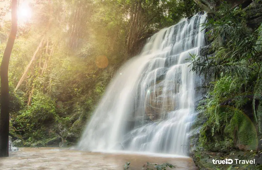
Dat Fa Waterfall, also commonly written in official tourism sources as Tad Fa Waterfall, is a natural waterfall in Chaiyaphum Province, located near Ban Na Wang in Na Siao Subdistrict, Mueang Chaiyaphum District. It lies within the eastern side of Tat Ton National Park and is known for its wide sloping rock platform, where water flows gently down the stone surface like a natural slide. Unlike waterfalls that drop vertically from a high cliff, Dat Fa Waterfall spreads across a broad rock terrace, creating a smooth, open, and distinctive waterfall landscape surrounded by dense mixed deciduous forest.
The waterfall is located about 4 km north of Ban Na Wang, with an additional walking distance of about 500 meters from the access area to the waterfall itself. The road toward the area is paved, making the approach more convenient than many forest waterfalls that require rough dirt roads. However, the short walk is still an important part of the experience. Visitors leave the vehicle area, walk into a more natural setting, and gradually reach the broad stone slope where the water flows over the rock surface. This gives the visit a stronger sense of discovery than a simple roadside stop.
The physical form of Dat Fa Waterfall is its main attraction. The rock terrace is about 50 meters wide and slopes for around 200 meters. Water flows down the inclined stone surface rather than falling sharply from a tall cliff. When the water level is suitable, the entire rock area becomes a broad sheet of flowing water. This makes the waterfall visually different from many other waterfalls in Chaiyaphum. It is suitable for sightseeing, photography, geological observation, and careful water recreation in safe conditions.
The name “Dat Fa” suggests the impression of a broad natural platform, while the name “Tad Fa” used by many official sources reflects the local use of the word “tad” for water flowing over a rock terrace or rapid-like surface. Both names refer to the same natural site. The important feature is the wide sloping rock sheet, the stream that flows over it, and the forested surroundings that make the waterfall a distinctive part of the Na Siao landscape.
Dat Fa Waterfall belongs to the ecosystem of Tat Ton National Park, a protected area on the Phu Laen Kha mountain range. The park contains hills, forest, streams, and several waterfalls. It plays an important role as a watershed area for Chaiyaphum Province. Visiting Dat Fa Waterfall allows travelers to see how forest, stone, and seasonal water work together. The waterfall is not only a place for recreation; it is also part of a larger natural system that supports local streams, vegetation, and downstream communities.
The mixed deciduous forest on both sides of the waterfall creates a shaded and refreshing atmosphere. Trees and understory plants help cool the area, reduce heat over the stone surface, and support the moisture of the stream during the rainy season. As visitors walk closer to the waterfall, the sound of flowing water becomes clearer and the air feels cooler. This is one of the most pleasant aspects of the site: the transition from rural road to forest trail and finally to the open rock-and-water landscape.
Dat Fa Waterfall is suitable for visitors who want a nature experience that is accessible but still authentic. The walk is not very long, yet it is enough to create a sense of entering a natural area. The destination is ideal for travelers who enjoy quiet waterfalls, short walks, natural rock formations, and less commercialized outdoor settings. It is also a good option for visitors who want to explore a different side of Tat Ton National Park beyond the better-known Tat Ton Waterfall.
Popular activities include viewing the broad waterfall surface, taking nature photographs, resting near the stream, observing the rock formations, and enjoying water recreation only when conditions are safe. The sloping rock surface can resemble a natural slide, but visitors should treat it with caution. Natural stone is uneven and can be very slippery, especially when covered with water or algae. Sliding, running, or jumping on the rock surface can be dangerous. Water play should be limited to safe areas and should always be supervised.
The best season to visit Dat Fa Waterfall is from the rainy season to the early cool season. During this period, the waterfall usually has better water flow, the forest is greener, and the sloping rock terrace becomes more attractive. In the dry season, the water may decrease significantly, and the waterfall may lose much of its visual impact. Travelers who want to see the waterfall at its best should visit after seasonal rainfall, while avoiding days of heavy rain or possible flash flood conditions.
For photography, Dat Fa Waterfall offers strong natural compositions. The main subjects include the wide rock terrace, thin sheets of water, forest on both sides, water channels carved into stone, and seasonal reflections on the rock surface. Morning light is usually softer and more comfortable, while late afternoon can give a warmer forest atmosphere. Wide-angle shots are useful for showing the scale of the sloping stone surface, while closer images of water patterns and rock textures help tell the geological story of the place.
Families can visit Dat Fa Waterfall, especially with older children who can walk safely along a natural trail. Parents should supervise children closely at all times. Children should not run on wet stone, approach fast-moving water, or play on the sloping rock without adult guidance. This is a natural waterfall, not a built water park. The ground is uneven, the rock may be slippery, and water depth can change from place to place.
The waterfall is also suitable for groups of friends who want a short nature trip from Chaiyaphum town. The site can be combined with Tat Ton Waterfall, Pha Koeng, Wat Chaiyaphum Phithak, Phu Laen Kha National Park, and Mo Hin Khao. A well-planned day trip can begin with Dat Fa Waterfall in the morning, continue to Tat Ton or Pha Koeng in the afternoon, and end with a scenic viewpoint or a local restaurant before returning to town.
Getting There from Chaiyaphum town is most convenient by private car or rental car. Travel toward Na Siao Subdistrict and Ban Na Wang. Local information describes the waterfall as being about 4 km north of Ban Na Wang, with a paved road leading toward the area. After reaching the parking or access point, visitors walk about 500 meters to the waterfall. Because local road conditions and access points can vary by season, first-time visitors should use map navigation and confirm directions with park staff or local residents.
Before starting the walk, visitors should prepare essential items: drinking water, shoes with good grip, a waterproof pouch for valuables, a towel, insect repellent, and a rubbish bag. Avoid carrying heavy items because the trail includes a natural walking section. After rain, the ground and rocks may be slippery, so walking slowly is important. Visitors unfamiliar with the route should not enter alone and should avoid starting the walk late in the day.
The main zones of Dat Fa Waterfall can be understood by function: the Ban Na Wang access road, the parking and walking-start area, the 500-meter nature trail, the mixed deciduous forest zone, the broad rock terrace, the sloping water-slide-like rock surface, the lower pool area, and the connecting route to other Tat Ton and Phu Laen Kha attractions. Understanding these zones helps visitors plan their time, stay safe, and use the area responsibly.
The sloping rock zone is the most scenic but also the area that requires the most caution. Wet rock can be slippery even when it looks safe. Visitors should walk carefully, avoid running, and stay away from strong water channels. Photographers should secure their footing before taking photos. Waterfall accidents often happen when people focus on cameras or phones and forget the condition of the rock beneath them.
Dat Fa Waterfall is also a useful outdoor classroom for understanding natural landforms. The broad rock surface, water channels, pools, and slope show how water slowly shapes stone over time. The waterfall was not created by water alone; it is the result of rock structure, slope, seasonal flow, forest cover, and long-term erosion. This makes the site meaningful for students, families, and travelers interested in geology and natural processes.
Conservation is essential because the waterfall is inside a national park and forms part of a watershed ecosystem. Visitors should not leave plastic bottles, food waste, bags, or any rubbish in the area. Do not write on rocks, remove plants, disturb wildlife, or walk outside appropriate routes. Carrying out all waste is the simplest and most effective way to keep the waterfall clean and safe for future visitors.
Visitors should not begin the trail close to evening because the walking path has no lighting and wet rock becomes more dangerous in low light. Morning or early afternoon is a better choice. Those who want late-day photographs should make sure they have enough time to return safely before dark. A waterfall trip should be planned around safety first, scenery second.
Dat Fa Waterfall pairs well with Tat Ton Waterfall because both are part of the same broader protected landscape but offer different experiences. Tat Ton is the more established and well-known waterfall with visitor services, while Dat Fa is quieter and more strongly defined by its sloping rock terrace. Visiting both allows travelers to understand the diversity of waterfalls within the Phu Laen Kha and Tat Ton area.
Nearby attractions include Tat Ton Waterfall, Pha Koeng or Wat Chaiyaphum Phithak, Phu Laen Kha National Park, Pha Hua Nak, Mo Hin Khao, Khlong Chang Rock Group, Wat Tha Hin Ngom, and Phra That Chaiyaphum. A half-day trip can focus on Dat Fa and a nearby food stop. A full-day route can include Tat Ton and Pha Koeng. A 2-day itinerary can add Mo Hin Khao, Phu Laen Kha viewpoints, and accommodation near Chaiyaphum town or the national park route.
Food options are best planned along the Tat Ton, Phu Laen Kha, or Chaiyaphum town route because the immediate waterfall area does not have dense restaurant services. Practical options include Farm Promma, Mahot Cafe Phumet, Ahan Suan Khonphon, Suan Ahan Pornthip, Skyline Chaiyaphum, and local restaurants in Chaiyaphum town. Visitors should bring drinking water and light snacks before walking to the waterfall, but all waste must be carried out.
Accommodation options include Tat Ton National Park accommodation, local stays near the Phu Laen Kha route, and hotels in Chaiyaphum town. Travelers who prefer nature-based stays can consider Tat Ton National Park accommodation, Farm Promma, Ban Rai Ruean Khwan, or On The Rock Chaiyaphum. Those who prefer town convenience can stay at Siam River Resort, Lertnimitra Hotel, Dee Prom Hotel, or The Peak Resort Chaiyaphum and visit Dat Fa Waterfall as a day trip.
The admission fee follows Tat Ton National Park rates because the waterfall is located inside the park area. Published rates include Thai adults 40 baht, Thai children 20 baht, foreign adults 200 baht, and vehicle fee 30 baht. Visitors should carry some cash because smaller park access points may not always support electronic payment. Park tickets should be kept during travel within the protected area.
The most important safety issue is water and rock condition during the rainy season. Heavy rain upstream can make the stream rise quickly even if rain is not falling directly at the waterfall. Visitors should leave the water immediately if the water becomes muddy, louder, or visibly stronger. Do not stand in the middle of strong current, do not climb slippery rock, and do not ignore natural warning signs. A beautiful waterfall is safest when respected.
Overall, Dat Fa Waterfall is a memorable natural destination for travelers who want to experience a quieter waterfall in Chaiyaphum. Its strengths are the broad sloping rock terrace, seasonal water flow, mixed deciduous forest, short walking trail, and connection with Tat Ton National Park. With proper preparation, good timing, and responsible behavior, Dat Fa Waterfall offers a refreshing and authentic nature experience in Chaiyaphum Province.
| Name | Dat Fa Waterfall Or Tad Fa Waterfall |
| Location | Ban Na Wang, Na Siao Subdistrict, Mueang Chaiyaphum District, Chaiyaphum Province, on the eastern side of Tat Ton National Park |
| Address | Na Siao Subdistrict, Mueang Chaiyaphum District, Chaiyaphum 36000, Thailand |
| Highlights | A waterfall on a broad sloping rock terrace, with water flowing like a natural slide, surrounded by dense mixed deciduous forest and reached by a short nature walk |
| History / Local Role | A natural waterfall in the eastern part of Tat Ton National Park, connected with the Phu Laen Kha watershed landscape and the natural tourism identity of Na Siao Subdistrict |
| Name Origin | “Dat Fa” refers to the broad rock surface resembling a natural platform, while “Tad Fa” reflects the local term for water flowing over a wide rock terrace or rapid-like surface |
| Distinctive Features | A rock terrace about 50 meters wide, a slope of about 200 meters, seasonal water flow over inclined stone, mixed deciduous forest on both sides, and a short walking trail |
| Travel Information | From Chaiyaphum town, travel toward Na Siao Subdistrict and Ban Na Wang. The waterfall is about 4 km north of Ban Na Wang. The road is paved to the access area, followed by a walk of about 500 meters |
| Current Status | Open as a natural attraction inside Tat Ton National Park, suitable for seasonal waterfall viewing, short nature walking, photography, and careful water recreation |
| Open Days | Daily |
| Opening Hours | 06.00 – 18.00 |
| Fees | Tat Ton National Park rates: Thai adults 40 baht, Thai children 20 baht, foreign adults 200 baht, vehicle fee 30 baht |
| Best Visiting Time | Rainy season to early cool season, when water flow is stronger, the forest is greener, and the rock terrace scenery is at its best |
| Facilities | Paved access road, parking where available, natural walking trail, and visitor services/accommodation at the main Tat Ton National Park area |
| Main Areas / Zones | 1. Ban Na Wang Access Zone 2. Parking And Trailhead Zone 3. 500-Meter Nature Trail Zone 4. Mixed Deciduous Forest Zone 5. Main Broad Rock Terrace Zone 6. Natural Slide-Like Sloping Rock Zone 7. Lower Pool Resting Zone 8. Connecting Route To Tat Ton And Phu Laen Kha Attractions |
| Caretaker / Related Authority | Tat Ton National Park, Department Of National Parks, Wildlife And Plant Conservation / Ranger Unit Ton.3 (Tad Fa) / Na Siao Subdistrict Administrative Organization as the local authority |
| Main Contact Number | Tat Ton National Park, Tel. 044-853-293, 044-853-333 Tat Ton National Park Visitor Center, Tel. 044-104-002-3 Na Siao Subdistrict Administrative Organization, Tel. 044-884-111 |
| Official Website / Official Page | Tat Ton National Park Official Page, Tourism Authority Of Thailand, Na Siao Subdistrict Administrative Organization |
| Nearby Tourist Attractions | 1. Tat Ton Waterfall / Tat Ton National Park, about 18 km, Tel. 044-853-293, 044-853-333 2. Pha Koeng / Wat Chaiyaphum Phithak, about 14 km 3. Phu Laen Kha National Park, about 15 km 4. Pha Hua Nak, about 20 km 5. Mo Hin Khao, about 22 km 6. Khlong Chang Rock Group, about 23 km 7. Phra That Chaiyaphum, about 28 km |
| Nearby Restaurants | 1. Farm Promma, about 20 km, Tel. 088-565-2654 2. Mahot Cafe Phumet, about 22 km, Tel. 081-371-0058 3. Ahan Suan Khonphon, about 25 km, Tel. 081-074-6840 4. Suan Ahan Pornthip Chaiyaphum, about 28 km, Tel. 090-823-7880 5. Skyline Chaiyaphum, Mo Hin Khao Zone, about 25 km, Tel. 062-415-2392, 095-613-6544 |
| Nearby Accommodations | 1. Tat Ton National Park Accommodation, about 18 km, Tel. 044-853-293, 044-853-333 2. Farm Promma, about 20 km, Tel. 088-565-2654 3. Ban Rai Ruean Khwan, about 30 km, Tel. 061-828-9159, 061-226-1465, 044-056-177 4. The Peak Resort Chaiyaphum, about 35 km, Tel. 082-615-5587 5. Siam River Resort Chaiyaphum, about 32 km, Tel. 044-811-999 6. Hotels In Chaiyaphum Town, about 30 – 35 km |
Frequently Asked Questions (FAQ)
Q: Where is Dat Fa Waterfall located?
A: Dat Fa Waterfall is located near Ban Na Wang, Na Siao Subdistrict, Mueang Chaiyaphum District, Chaiyaphum Province, on the eastern side of Tat Ton National Park.
Q: Are Dat Fa Waterfall and Tad Fa Waterfall the same place?
A: Yes. They refer to the same waterfall. “Dat Fa” appears in some sources, while “Tad Fa” is widely used in official tourism and local sources.
Q: What makes Dat Fa Waterfall special?
A: Its main feature is a broad sloping rock terrace where water flows like a natural slide, surrounded by dense mixed deciduous forest.
Q: How far is the walk to Dat Fa Waterfall?
A: Visitors walk about 500 meters from the access or parking area to reach the waterfall.
Q: When is the best time to visit Dat Fa Waterfall?
A: The rainy season to early cool season is the best period because the waterfall has better water flow and the surrounding forest is greener.
Q: Is there an entrance fee for Dat Fa Waterfall?
A: Yes. Since the waterfall is inside Tat Ton National Park, park fees apply: Thai adults 40 baht, Thai children 20 baht, foreign adults 200 baht, and vehicle fee 30 baht.
Q: Can visitors swim at Dat Fa Waterfall?
A: Water recreation is possible only in suitable areas when conditions are safe. Visitors must be careful of slippery rock, deep water, and strong current, especially after heavy rain.
Q: What nearby attractions can be combined with Dat Fa Waterfall?
A: Nearby attractions include Tat Ton Waterfall, Pha Koeng, Phu Laen Kha National Park, Pha Hua Nak, Mo Hin Khao, Khlong Chang Rock Group, and Phra That Chaiyaphum.
 Category: ●Nature and Wildlife
 Group: ●Waterfalls
Last Update : 3 MonthAgo
 Last Update : 3 MonthAgo
 Click to Access the Navigation Map GPS
 Art, Culture and Heritage
 Historical Sites and Monuments(1)
 Landmarks and Memorials(3)
 Royal Palace(1)
 Art, Craft Centres, Tradition(3)
 Educational Places
 Educational Gardens, Farm(1)
 Places of Worship
 Temple(141)
 Other Sacred Sites(7)
 Suburban Living
 Village, Community(4)
 National Parks and Marine Reserves(7)
 Mountain (Doi)(5)
 Dam, Reservoir, Lake(10)
Waterfalls(15)
Dam, Reservoir, Lake(10)
Waterfalls(15)
 Caves(5)
 River, Canal(4)
 Other natural attractions(1)
 Entertainment and Agricultural
 Farms, Parks and Ecotourism(2)


