
lovethailand home >South Travel Attractions >Ranong Travel Attractions >Muang Ranong >Koh Phayam > Mu Ko Ranong National Park
TL;DR: Mu Ko Ranong National Park, open Daily For Park Headquarters And Accessible Mainland Areas / Some Island Areas, hours 08.30 – 16.30.
Mu Ko Ranong National Park
Open Days: Daily For Park Headquarters And Accessible Mainland Areas / Some Island Areas And Overnight Sites Open Seasonally
Opening Hours: 08.30 – 16.30
Mu Ko Ranong National Park, formerly known as Mu Ko Phayam National Park, is one of the most important marine national parks in Ranong Province. It covers coastal areas, mangrove forests, nearshore islands, offshore islands, coral reefs, seagrass beds, beaches, island forests and local island communities in Mueang Ranong District. Many travelers still know the area by its former name, Mu Ko Phayam National Park, because Ko Phayam is the best-known island in the park landscape. The current official name, however, is Mu Ko Ranong National Park, following the name change on 23 February 2010. This destination should therefore be understood in two layers: the protected marine national park that safeguards Ranong’s coastal and island ecosystems, and Ko Phayam, the island community most visitors use as the main travel base.
The park headquarters are located at 192 Moo 4, Ngao Subdistrict, Mueang Ranong District, Ranong Province 85000. Ko Phayam is located in Moo 1, Ko Phayam Subdistrict, Mueang Ranong District, about 33 kilometres from Pak Nam Ranong. The main access is by boat from Pak Nam Municipal Pier or the Sapan Pla pier area to Ao Mae Mai Pier on Ko Phayam. Speedboats usually take about 40–45 minutes, while normal passenger boats take about 2–2.30 hours depending on boat type, sea condition and seasonal schedule.
Ko Phayam is widely remembered as a natural, relaxed and modestly developed island. It covers about 35 square kilometres and contains forest, cashew orchards, long beaches, quiet bays, small island roads and a slower pace of life. Unlike larger commercial island destinations, Ko Phayam does not function around ordinary car traffic. Local transport is mainly by motorcycle taxi, rental motorcycle, bicycle or small local vehicles. This slower rhythm is part of the island’s appeal and makes it suitable for travelers who want simplicity rather than heavy tourism infrastructure.
Ao Mae Mai, on the eastern side of Ko Phayam, is the main arrival area. It is the island’s principal pier and the first place most visitors encounter after the boat journey. The area has shops, restaurants, motorcycle rental points, guesthouses and basic community services. It is the natural starting point for understanding Ko Phayam because it connects transport, local life, tourism services and the sea. From Ao Mae Mai, travelers can continue to Ao Yai, Ao Khao Khwai, Wat Ko Phayam and other nature points around the island.
Ao Yai lies on the western side of Ko Phayam and is one of the island’s broadest and longest beaches. The beach stretches for about 3–4 kilometres and is one of the best sunset spots on the island. Ao Yai is suitable for beach walks, swimming when the sea is calm, seasonal wave activities, beachfront stays and quiet evening relaxation. The bay reflects the character of Ko Phayam clearly: a long beach, small restaurants, bungalows, beach bars, independent travelers and a peaceful atmosphere rather than a dense resort strip.
Ao Khao Khwai, also on the western side, is another major highlight. The bay curves inward like buffalo horns, which gives it its Thai name. The area has sand, sea, rock formations and photogenic coastal scenery, especially Hin Thalu, a natural sea-rock formation with an opening through the stone. Ao Khao Khwai is excellent for sunset viewing, beach walking, photography and slow coastal relaxation. The southern side of the bay is also connected with a Moken community, adding a cultural dimension to the coastal landscape.
Wat Ko Phayam and the sea chapel are important cultural and religious stops on the island. The chapel sits on a small offshore structure connected by a bridge, with sea and island scenery around it. Many visitors come to pay respect, make merit, take photos and enjoy the view. Proper temple etiquette matters here. Visitors should dress modestly, speak quietly and remember that the place is not only a photo spot, but also a religious site for the island community.
Ko Phayam is also known for cashew, locally called kayu or gah-yu. Cashew trees grow well on the island and have become part of the local economy. Visitors can find roasted cashews, salted cashews and seasoned cashew products in local shops. Buying these products supports island households and connects tourism with local agriculture rather than only with beaches and accommodation.
Another distinctive feature of Ko Phayam is that hornbills can be seen more easily than in many other island destinations. The remaining forest provides feeding and nesting habitat for large birds. Hornbills are meaningful ecological indicators because they require mature trees, tree cavities and forest fruits. Watching hornbills on Ko Phayam should be done quietly and from a respectful distance. Visitors should not disturb nesting areas or feed wildlife.
Within the national park context, Mu Ko Phayam does not mean only Ko Phayam. It refers to a wider island and coastal system along the northern Andaman Sea of Ranong. The original protected-area planning covered several national reserved forests, including Ko Phayam Forest, Ko Chang Forest, Khlong Hin Kong–Khlong Muang Kluang Forest and Khlong Hua Khiao–Khlong Ko Sui Forest. The Royal Forest Department began surveying the area for national park establishment in 1989, followed by boundary adjustment and official park development to support both conservation and local community needs.
The park landscape can be understood in three main geographical groups: coastal areas, nearshore islands and offshore islands. Coastal areas include extensive mangrove forests that protect shorelines and serve as nursery grounds for aquatic life. Nearshore islands such as Ko Bang Chak, Ko Yio, Ko Sai Dam and Ko Son combine mangroves on the eastern sides, sandy beaches on the western sides and evergreen forest on the island interiors. Offshore islands such as Ko Phayam, Ko Chang, Ko Thalu, Ko Ta Khrut, Ko Mo, Ko Pring, Ko Rai and Ko Fai Mai include evergreen forest, beach forest, coral reefs and marine habitats.
Ko Chang is another important island in Mu Ko Ranong National Park. It is quieter and more natural than Ko Phayam in many ways, with fishing communities, mangrove areas, Ao Khai Tao, Ao Khang Khao and peaceful coastal scenery. Some parts of Ko Chang and Ao Khai Tao are closed to tourism and overnight stays from 16 May to 14 October each year. This seasonal closure supports ecosystem recovery and visitor safety during the monsoon period. Travelers planning to visit Ko Chang should check park announcements before departure.
Ko Sai Dam is notable for its old community and unusual black sand beach. The dark beach surface was formed from soil, wood fragments and natural materials accumulated over time. The island community is linked with coastal fishing, shrimp paste making, local fishing knowledge and mangrove learning. Laem Makham on the island has a rich mangrove ecosystem and a nature-study route. Visiting Ko Sai Dam gives travelers a different experience from Ko Phayam because it highlights community life and rare coastal landforms.
Ko Fai Mai and Hat Hin Ngam are suitable for travelers interested in coastal rock formations. Hat Hin Ngam is known for small rounded stones of varied colours naturally arranged along the beach. When waves and sunlight move across them, the stones appear glossy and striking. Visitors should not remove stones from the area, climb unsafe rocks or leave rubbish. Coastal rock beaches take a long time to form naturally and should be treated as protected landscapes.
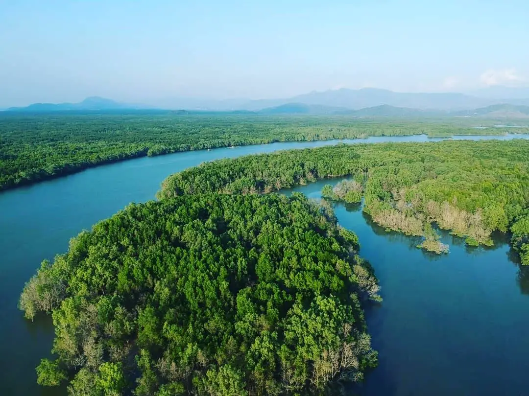
The mangrove ecosystem of Mu Ko Ranong National Park is nationally and internationally significant. Ranong’s coast is part of the Ranong Biosphere Reserve, designated by UNESCO in 1997, and contains some of Thailand’s most important mangrove forests. Mangrove plants in the area include Avicennia species, Bruguiera species, Ceriops, Excoecaria, Intsia, Lumnitzera, Rhizophora, Sonneratia, Xylocarpus and nipa palm. These trees stabilize mud, reduce wave energy, provide food and shelter, and form nursery habitats for many young aquatic animals.
Evergreen forest is found on several islands, including Ko Bang Chak, Ko Yio, Ko Chang, Ko Sai Dam and Ko Phayam. These forests remain humid and support island wildlife. Common tree and plant groups include wild fruit trees, dipterocarps, forest trees, rattans, ferns, mosses and epiphytes. This makes the park much more than beaches and sea. It is also an island rainforest landscape with complex life from the canopy to the forest floor.
Beach forest appears along parts of Ko Phayam, Ko Chang and Ko Sai Dam. Typical beach-forest plants include casuarina, sea almond, pandanus and coastal cycads. These plant communities help stabilize sand, reduce wind impact and provide shade and habitat. Some islands also have grassland areas, particularly Ko Yio and Ko Sai Dam, where cogon grass and open woodland form another landscape type. The park therefore contains mangroves, evergreen forest, beach forest and open grassland within one protected system.
Seagrass beds are another important resource around Ko Phayam and nearby islands. Older surveys recorded several seagrass species in the former Mu Ko Phayam National Park area, including species of Cymodocea, Halophila, Halodule and Enhalus. More recent 2025 monitoring by the Department of Marine and Coastal Resources found about 33 rai of seagrass around Ko Phayam and recorded 9 seagrass species. Seagrass beds are essential marine habitats because they provide food, shelter and nursery areas for coastal and marine animals.
Coral reefs occur in several areas, including Ao Kwang Peep, Ao Mae Yai, Ko Phayam, Ko Thalu, Ao Khang Khao and Ko Chang. Coral types include massive coral, brain coral, branching coral, staghorn coral, finger coral, table coral, lettuce coral and soft corals in some places. Other marine life includes sea fans, hydroids, sea anemones and colourful reef fish such as clownfish, angelfish, triggerfish, moray eels, scorpionfish and lionfish. Snorkeling and swimming in reef areas must be done carefully without stepping on, touching or collecting marine life.
Wildlife in Mu Ko Ranong National Park is diverse because the park contains land forest, mangrove forest, beaches, mudflats, coral reefs and open sea. Mammals include long-tailed macaques, otters, flying lemurs, squirrels, treeshrews, wild boar, civets and small rodents. Birdlife includes hornbills, egrets, raptors, swallows, waterhens, magpie-robins, cormorants and kingfishers. Reptiles include lizards, monitor lizards, snakes and turtles, while amphibians include frogs, toads and tree frogs. Insects, crabs, fish, molluscs and other small organisms also form important parts of the food web.
The marine and mangrove fauna include fiddler crabs, sesarmid crabs, mud crabs, hermit crabs, banana prawns, krill, snapping shrimp, mud lobsters, oysters, tower shells, white clams, mudskippers, gobies, mullets, pufferfish, barracuda, red snapper, barramundi, groupers, mackerel, squid, sea urchins, sea cucumbers and coral-associated organisms. This biological richness supports local fishing communities and explains why the area requires national park protection.
The climate is strongly influenced by monsoons. The rainy season begins around mid-May and continues to mid-October, with June to September usually bringing heavy rain. Sea conditions can be rough, and boat schedules may be reduced or adjusted. The cooler travel period runs from mid-October to mid-February, though temperatures remain mild because the area is coastal. The hot season runs from mid-February to mid-May, but sea breezes help reduce extreme heat.
The best general period to visit Ko Phayam and Mu Ko Ranong is from November to April, when the sea is calmer and boat travel is more reliable. This period is suitable for beach stays, island hopping, snorkeling and relaxed island travel. From May to October, some mainland and community areas may still be accessible, but travelers should check weather, boat schedules and park closure announcements carefully, especially for Ko Chang and Ao Khai Tao.
Recommended activities on Ko Phayam include walking along Ao Yai, watching the sunset at Ao Khao Khwai, visiting Wat Ko Phayam and the sea chapel, kayaking in calm water, riding around the island by motorcycle, tasting seafood, buying cashew products, watching hornbills, exploring forested areas and taking authorized boat trips around the island or to snorkeling points. A stay of at least 2 days and 1 night is recommended because a same-day trip leaves little time to experience the island atmosphere properly.
Responsible travel is essential in the national park. Visitors should not remove coral, shells, stones, plants or animals from the area. Do not feed wildlife, litter, ride outside designated routes, disturb animals, light fires in prohibited areas or take boats when conditions are unsafe. Wear a life jacket on boats, protect documents and electronics with waterproof bags, and allow enough time to return to the mainland when connecting with flights, buses or onward travel.
Getting There to the mainland headquarters of Mu Ko Ranong National Park is done from Ranong town by taking Highway 4 on the Ranong–Takua Pa route for about 14 kilometres to Ngao Subdistrict, then turning into the Ngao municipality area and continuing along the Ban Lang–Hua Thanon road for about 4 kilometres. To reach Ko Phayam, travel to Pak Nam Municipal Pier or the Sapan Pla pier area in Pak Nam Subdistrict, then take a boat to Ao Mae Mai Pier on Ko Phayam. Current passenger-boat fares are generally about 200–250 baht per trip, while speedboats are about 350–400 baht per trip. Schedules change by season and sea conditions.
Travelers from Bangkok can follow Highway 4 south through Chumphon into Ranong and continue to Pak Nam Pier. Travelers arriving by air can land at Ranong Airport and take local transfer to the pier. Private transport is useful for mainland attractions such as the park headquarters, Ranong Mangrove Research Centre, Phu Khao Ya, Raksa Warin Hot Spring and Ranong town. Once on Ko Phayam, travelers should plan to use motorcycle taxis or rental motorcycles according to island road conditions.
Overall, Mu Ko Ranong National Park, formerly Mu Ko Phayam National Park, brings together some of the strongest natural identities of Ranong: extensive mangrove forest, Ko Phayam, Ko Chang, Ko Sai Dam, Ko Fai Mai, Hat Hin Ngam, Ao Mae Mai, Ao Yai, Ao Khao Khwai, cashew orchards, hornbills, coral reefs, seagrass beds, fishing communities and a quieter island way of life. Travelers who want to understand Ranong beyond a simple beach holiday should give this area enough time. It is not only a seaside retreat, but also a large natural classroom where sea, forest, islands, people and conservation remain closely connected.
| Name | Mu Ko Ranong National Park / Formerly Mu Ko Phayam National Park |
| Main Travel Areas | Ko Phayam, Ko Chang, Ko Sai Dam, Ko Fai Mai, Ko Bang Chak, Ko Yio, Ko Son, Ko Thalu, Ko Ta Khrut, Ko Mo, Ko Pring And Ko Rai |
| Place Type | Marine National Park, Island Group, Mangrove Forest, Beach, Evergreen Forest, Coral Reef And Seagrass Habitat |
| Park Headquarters Address | 192 Moo 4, Ngao Subdistrict, Mueang Ranong District, Ranong Province 85000 |
| Ko Phayam Location | Moo 1, Ko Phayam Subdistrict, Mueang Ranong District, Ranong Province, about 33 km from Pak Nam Ranong |
| Reference Coordinates | 9.736814, 98.401975 |
| Coverage Area | Ko Phayam, Ngao, Ratchakrut And Pak Nam Subdistricts In Mueang Ranong District, Ranong Province |
| Area Size | Marine national park data lists about 379 square kilometres; earlier planning data listed about 347 square kilometres. |
| National Park Declaration | 23 December 2009 |
| Name Change | Changed From Mu Ko Phayam National Park To Mu Ko Ranong National Park On 23 February 2010 |
| Park Chief / Responsible Officer | Suwanna Sa-At |
| Contact Numbers | 077-813-828, 077-880-438 |
| Highlights | Ko Phayam, Ao Yai, Ao Khao Khwai, Ao Mae Mai, Wat Ko Phayam, Sea Chapel, Ko Chang, Ko Sai Dam, Hat Hin Ngam, Ko Fai Mai, Mangroves, Coral Reefs, Seagrass Beds, Hornbills And Cashews |
| Main Zones | Ngao Headquarters Zone, Coastal Mangrove Zone, Nearshore Island Zone, Ko Phayam Zone, Ko Chang Zone, Ko Sai Dam Zone, Hat Hin Ngam Zone And Coral Reef Zone |
| Important Ecosystems | Mangrove Forest, Evergreen Forest, Beach Forest, Island Grassland, Sandy Beach, Mudflat, Coral Reef, Seagrass Bed And The Upper Andaman Sea |
| Recommended Activities | Ko Phayam Travel, Beach Walking, Sunset Viewing, Snorkeling In Permitted Areas, Kayaking, Hornbill Watching, Buying Cashew Products, Mangrove Learning, Ko Chang Travel, Ko Sai Dam Travel And Nature-Based Relaxation |
| Current Status | Open As A National Park And Marine Tourism Area In Ranong Province, With Some Island Areas And Overnight Sites Open Or Closed Seasonally According To Park Announcements |
| Open Days | Daily For Park Headquarters And Accessible Mainland Areas / Some Island Areas And Overnight Sites Open Seasonally |
| Opening Hours | 08.30 – 16.30 |
| Seasonal Closure | Ao Khai Tao And Ko Chang Are Closed To Tourism And Overnight Stays From 16 May To 14 October Each Year. |
| Admission Fee | Thai Adult 40 Baht, Thai Child 20 Baht / Foreign Adult 200 Baht, Foreign Child 100 Baht |
| Boat Fare To Ko Phayam | Normal passenger boat about 200–250 baht per trip, about 2–2.30 hours / speedboat about 350–400 baht per trip, about 40–45 minutes |
| Facilities | Park Headquarters, Accommodation And Camping In Some Areas, Visitor Service Points, Ao Mae Mai Pier, Shops, Restaurants, Ko Phayam Accommodation, Motorcycle Taxis, Motorcycle Rentals And Seasonal Boat Services |
| Visitor Etiquette | Wear A Life Jacket On Boats, Do Not Remove Coral, Stones, Shells, Plants Or Animals, Do Not Feed Wildlife, Do Not Litter, Do Not Step On Coral And Follow Park Staff Instructions. |
| Travel Information | To reach the mainland headquarters, take Highway 4 from Ranong town to Ngao Subdistrict, then continue on the Ban Lang–Hua Thanon route for about 4 km. To reach Ko Phayam, take a boat from Pak Nam Municipal Pier or Sapan Pla Pier to Ao Mae Mai Pier. |
| Nearby Tourist Attractions | 1. Ao Mae Mai, about 0 km from Ko Phayam Pier 2. Wat Ko Phayam And Sea Chapel, about 1 km from Ao Mae Mai Pier 3. Ao Khao Khwai And Hin Thalu, about 4–5 km from Ao Mae Mai Pier 4. Ao Yai, about 4 km from Ao Mae Mai Pier 5. Ko Kham, continuing by local boat from Ko Phayam 6. Ko Chang, continuing by boat from Pak Nam Pier or seasonal local boat 7. Ranong Mangrove Research Centre And Ranong Biosphere Reserve, about 4 km from the mainland park headquarters |
| Nearby Restaurants | 1. Koh Phayam Seafood, about 0.3 km from Ao Mae Mai Pier, Tel. 087-423-5641 2. The Blue Sky Restaurant Koh Payam, about 0.7 km from Ao Mae Mai Pier, Tel. 080-611-4614 3. Wandee Seafood Koh Phayam, about 1 km from Ao Mae Mai Pier, Tel. 089-587-5528, 065-232-9949, 082-818-4843 4. Tum Restaurant Ko Phayam, about 3–4 km from Ao Mae Mai Pier, Tel. 085-794-1349 5. Somtam Mae Kai Ko Phayam, about 4 km from Ao Mae Mai Pier, Tel. 064-048-8410 6. Hippy Bar Ao Khao Khwai, about 5 km from Ao Mae Mai Pier, Tel. 093-587-2910 |
| Nearby Accommodations | 1. The Blue Sky Resort Koh Payam, about 0.7 km from Ao Mae Mai Pier, Tel. 080-611-4614, 077-873-958 2. Nitiporn Resort, about 1 km from Ao Mae Mai Pier, Tel. 095-040-5216 3. Sabai Sabai Bungalows, about 2 km from Ao Mae Mai Pier, Tel. 087-895-4653, 080-849-7370 4. Phayamas Private Beach Resort & Island Brew, about 3 km from Ao Mae Mai Pier, Tel. 091-078-7715 5. Phayam Lodge, about 4 km from Ao Mae Mai Pier, Tel. 095-665-3915, 086-995-2598 6. Koh Phayam Green Tawan Resort, about 4 km from Ao Mae Mai Pier, Tel. 088-386-0903 |
Frequently Asked Questions (FAQ)
Q: Are Mu Ko Phayam National Park and Mu Ko Ranong National Park the same place?
A: Yes. Mu Ko Phayam National Park is the former name. The current official name is Mu Ko Ranong National Park, following the name change on 23 February 2010.
Q: Where is Mu Ko Ranong National Park located?
A: The park headquarters are located at 192 Moo 4, Ngao Subdistrict, Mueang Ranong District, Ranong Province 85000. Ko Phayam, one of the main travel areas, is in Moo 1, Ko Phayam Subdistrict, Mueang Ranong District.
Q: What are the opening days and hours?
A: The park headquarters are open daily from 08.30 to 16.30. Some island areas and overnight sites open or close seasonally. Ao Khai Tao and Ko Chang are closed from 16 May to 14 October each year.
Q: What is the entrance fee for Mu Ko Ranong National Park?
A: The published fee is 40 baht for Thai adults, 20 baht for Thai children, 200 baht for foreign adults and 100 baht for foreign children. Boat fares, accommodation and special activities are charged separately.
Q: How do travelers get to Ko Phayam?
A: Travel to Pak Nam Municipal Pier or the Sapan Pla pier area in Pak Nam Subdistrict, Mueang Ranong District, then take a boat to Ao Mae Mai Pier on Ko Phayam. Speedboats take about 40–45 minutes, while normal passenger boats take about 2–2.30 hours.
Q: What are the main highlights of Ko Phayam?
A: The main highlights are Ao Yai, Ao Khao Khwai, Ao Mae Mai, Wat Ko Phayam, the sea chapel, cashew orchards, hornbills, quiet beaches and the island’s slow, motorcycle-based travel style.
Q: When is the best time to visit Ko Phayam and Mu Ko Ranong?
A: November to April is generally the best period for sea travel, beach stays and snorkeling. From May to October, travelers should check weather, boat schedules and national park closure announcements before traveling.
Q: How long should travelers stay on Ko Phayam?
A: At least 2 days and 1 night is recommended. This gives enough time for Ao Mae Mai, Ao Yai, Ao Khao Khwai, Wat Ko Phayam, sunset viewing, seafood, cashew products and the relaxed island atmosphere.
 Category: ●Nature and Wildlife
 Group: ●National Parks and Marine Reserves
Last Update : 2 WeekAgo
 Last Update : 2 WeekAgo
 Click to Access the Navigation Map GPS
Mu Ko Ranong National Park Map
Gellery
Recommend

 Art, Culture and Heritage
 Historical Sites and Monuments(4)
 Landmarks and Memorials(1)
 Royal Palace(1)
 Art, Craft Centres, Tradition(4)
 Educational Places
 Educational Gardens, Farm(1)
 Places of Worship
 Temple(12)
 Other Sacred Sites(2)
 Suburban Living
 Village, Community(2)
National Parks and Marine Reserves(6)
Village, Community(2)
National Parks and Marine Reserves(6)
 Mountain (Doi)(4)
 Waterfalls(15)
 Hot Springs(3)
 Caves(4)
 River, Canal(2)
 Bays and Beaches(10)
 Islands(8)
 Other natural attractions(3)


