
lovethailand home >South Travel Attractions >Ranong Travel Attractions >Muang Ranong >Ngao > Ngao Mangrove Forest Research Centre
TL;DR: Ngao Mangrove Forest Research Centre is located at Ban Lang, Moo 4, Ngao Subdistrict, Mueang Ranong District, Ranong Province, open Daily, hours 08.30 AM - 04.30 PM.
Ngao Mangrove Forest Research Centre
Open Days: Daily
Opening Hours: 08.30 AM - 04.30 PM
Ngao Mangrove Forest Research Centre, also known as Ranong Mangrove Forest Research Center, is located at 185 Moo 4, Ban Lang, Ngao Subdistrict, Mueang Ranong District, Ranong Province. It is one of Ranong’s most important eco-learning destinations, situated about 19 kilometers south of Ranong town along Phet Kasem Road. Around kilometer markers 626 - 627, visitors turn toward the Ngao municipal area and continue along a paved road for about 5 kilometers to reach the centre. The main highlights include a mangrove nature trail, educational signs, mangrove plants, long-tailed macaques, fiddler crabs, mudskippers, coastal birds, and the centre’s role as a key gateway to the Ranong Biosphere Reserve, declared by UNESCO in 1997. It is ideal for visitors who want to understand mangrove ecology, marine nursery habitats, coastal conservation, scientific research, and responsible eco-tourism in Ranong.
Ngao Mangrove Forest Research Centre is one of the most worthwhile natural learning sites in Ranong Province. It is not merely a roadside mangrove walk or a short nature stop. The centre connects scientific research, conservation, public education, and coastal ecosystem management in one accessible place. Located in Ngao Subdistrict on the Andaman coast, the area is shaped by tidal waterways, muddy soil, brackish water, and regular seawater movement. These conditions allow mangrove trees to grow densely and create a rich habitat for juvenile marine animals, birds, crabs, mudskippers, and many other coastal species.
The place is widely known among Thai travelers as Ngao Mangrove Forest Research Centre. In research and conservation contexts, it is also associated with Ranong Mangrove Forest Research Center and the management of Ranong’s mangrove biosphere reserve. Its address is 185 Moo 4, Ban Lang, Ngao Subdistrict, Mueang Ranong District, Ranong 85000. The centre serves as a welcome point for nature study, educational visits, research coordination, and public understanding of Ranong’s mangrove ecosystem.
The centre is especially important because it belongs to the wider Ranong Biosphere Reserve, which was declared under UNESCO’s Man and the Biosphere Programme in 1997. The reserve includes mangrove forests, coastal waters, tropical evergreen forest, seagrass beds, local communities, agricultural areas, and marine habitats. Mangroves are the most representative ecosystem in the reserve. A visit to Ngao Mangrove Forest Research Centre therefore introduces visitors to the heart of an internationally recognized coastal conservation landscape.
Mangroves in Ngao are crucial for marine life. The forest functions as a natural nursery for many species of fish, shrimp, crabs, shellfish, and small aquatic animals. Young marine creatures use mangrove roots, muddy ground, and brackish channels as shelter before they grow strong enough to move into the open sea. This is why a healthy mangrove forest supports coastal fisheries and helps maintain the wider Andaman marine ecosystem.
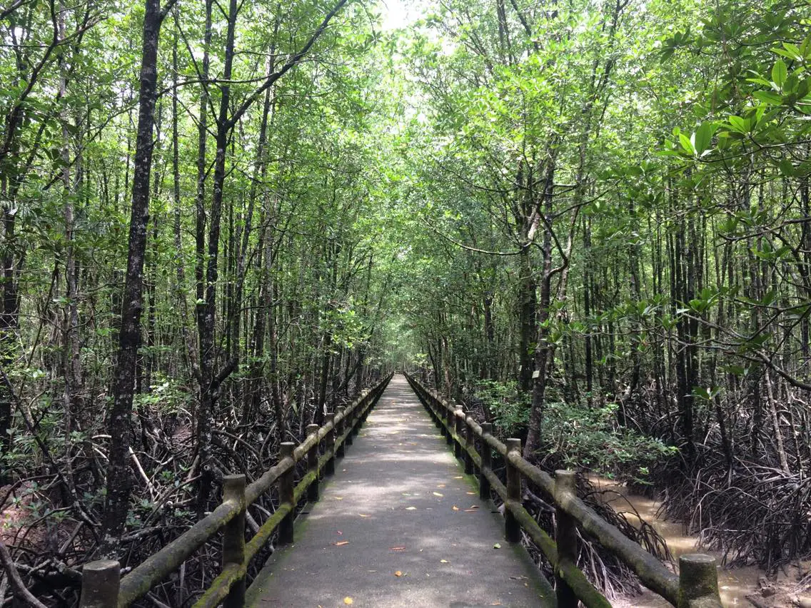
The nature trail is the easiest way to experience the ecosystem closely. The main concrete loop trail is about 850 meters long, with railings, resting points, and educational signs. Older travel descriptions refer to the overall nature-walk experience as roughly 2 kilometers. Along the route, visitors can observe prop roots, breathing roots, soft mud, crab holes, plant labels, shaded resting points, and the layered structure of a mature mangrove forest. The trail makes the hidden complexity of the mangrove ecosystem visible and easy to understand.
Mangrove plants are the core subject of the visit. Visitors can observe species such as Rhizophora mangroves, Avicennia, Xylocarpus, Bruguiera, Nypa palm, and other brackish-water plants. These plants survive in tidal mud, saline water, and low-oxygen soil through special adaptations. Prop roots support trees in soft ground, breathing roots take in air above the mud surface, and some mangrove seeds and propagules can float with the tide before rooting in suitable ground.
The biodiversity of Ranong Biosphere Reserve gives the centre both tourism and research value. Conservation sources identify more than 300 fauna species and more than 50 mangrove species within the reserve. Animals found in the mangrove landscape include long-tailed macaques, squirrels, monitor lizards, snakes, kingfishers, cormorants, Brahminy kites, mudskippers, crabs, benthic animals, and juvenile aquatic species. This makes the walk more than a simple forest stroll; every part of the mud, roots, canopy, and waterway contains ecological detail.
Long-tailed macaques are often seen around mangrove areas and access points. Visitors should watch them from a safe distance, avoid feeding them, keep food secured, avoid approaching young monkeys, and avoid teasing or provoking them. Feeding wildlife encourages aggressive behavior and dependence on humans. Responsible behavior protects both visitors and animals.
Crabs and mudflat animals are among the most fascinating parts of the mangrove experience. With careful observation, visitors may see fiddler crabs waving their larger claws, sesarmid crabs moving around burrows, and mudskippers crawling over the mud surface. These small creatures show that muddy ground is not empty or inactive. It is a living surface full of feeding, breathing, hiding, and territorial behavior.
For birdwatchers, the centre and the surrounding biosphere reserve offer strong potential. Mangroves, tidal channels, mudflats, and nearby coastal habitats support resident and migratory birds. Quiet visitors during the morning or late afternoon may see fish-eating birds, cormorants, Brahminy kites, kingfishers, and other coastal species. Binoculars or a telephoto camera help visitors observe birds clearly without disturbing them.
Ranong Biosphere Reserve follows the biosphere-reserve concept of core area, buffer zone, and transition area. The core area protects the most important and intact ecosystems. The buffer zone supports learning, research, and compatible conservation activities. The transition area includes human settlement, agriculture, and appropriate economic activity. This model shows that conservation does not always mean separating people completely from nature. Instead, it aims to balance protection, learning, and sustainable use.
The research role of the centre developed from the need to study and manage Thailand’s mangrove resources more effectively. As mangrove areas in Thailand declined and degraded due to intensive use, research centres became necessary for data collection, restoration planning, conservation experiments, and knowledge transfer. Ranong’s mangrove research work has supported both long-term ecological understanding and public education.
The centre is suitable for students, researchers, families, eco-travelers, and general visitors. The trail is not overly difficult, yet it contains many learning opportunities. Most visitors can spend around one to two hours walking the main trail, reading signs, observing plants and animals, and resting along the route. Groups that require deeper educational interpretation should contact the centre in advance so staff can prepare suitable guidance and explanations.
Getting There from Ranong town is straightforward by private car, rental car, or hired local transport. Follow Phet Kasem Road, or Highway 4, south toward the Ranong-Phang Nga route for about 19 kilometers. Around kilometer markers 626 - 627, turn right near the Ngao municipal area and continue along the paved road for about 5 kilometers to the centre. Public transport does not conveniently reach the entrance, so private transport is the most practical option.
The trip can be combined easily with nearby attractions in the Ngao area, including Grass Hill, Namtok Ngao National Park, Wat Ban Ngao, Ban Mueang Rae Nong Museum, Phon Rang Hot Spring, and Mu Ko Ranong National Park. A half-day route can begin at the mangrove centre in the morning, continue to Grass Hill and Ngao Waterfall, and then return to Ranong town for Rattanarangsan Palace, Raksawarin Hot Springs, or Rueang Rat Road in the afternoon.
The best time to walk the trail is in the morning or late afternoon. The weather is more comfortable, the light is better for photography, and wildlife activity may be easier to observe. Ranong is a rainy province, so visitors should prepare an umbrella, rain jacket, hat, drinking water, and comfortable walking shoes. The walkway is generally easy, but wet surfaces after rain require caution.
Responsible mangrove etiquette is essential. Visitors should not litter, feed wildlife, make excessive noise, collect plants or animals, step off the designated walkway, or disturb the mudflat ecosystem. Mangrove roots, crab holes, and small animals are fragile. Staying on the trail protects the forest and keeps the visit safe.
For deeper understanding, visitors should notice how the tide changes the forest. Ranong’s mangrove ecosystem is influenced by tides that rise and fall twice a day. At high tide, seawater enters channels and reaches mangrove roots. At low tide, the mud surface is exposed and many small animals become more visible. The same trail can therefore look and feel different at different times of day.
Mangroves also reduce wave energy, protect coastlines from erosion, trap sediment, store carbon, and filter water before it reaches the sea. Mangrove roots act like a living barrier, slowing water movement and holding mud in place. Leaves, branches, and organic matter become food for small animals and microorganisms, creating a food web that supports coastal life beyond the forest itself.
For Ranong Province, Ngao Mangrove Forest Research Centre adds an important ecological dimension to travel. Ranong is often known for hot springs, Koh Phayam, waterfalls, mountains, and Grass Hill, but this centre shows the coastal foundation behind the province’s marine life. Fish, shrimp, crabs, shellfish, and local fishing livelihoods are closely connected with healthy mangrove ecosystems.
Important things to observe include root structures, plant labels, mud texture, animal burrows, crab movement, bird calls, mangrove smell, and the cool shaded atmosphere under the canopy. Slow walking gives a much better experience than rushing. The forest is a natural classroom that combines ecology, geography, biology, conservation, and local coastal life.
Families with children can use the visit to explain mangrove roles in simple terms. Mangroves are homes for young marine animals, natural barriers for the coastline, food sources for communities, and important environmental protectors. Seeing roots, crabs, mudskippers, monkeys, and brackish water in person makes conservation easier to understand than reading about it alone.
For photographers, the centre offers calm and natural compositions. The long boardwalk creates strong leading lines into the forest, while mangrove roots and shade give depth and atmosphere. Low tide reveals mudflat life more clearly. Photography should be done from designated paths, without loud sounds, baiting, feeding animals, or using flash close to wildlife.
Overall, Ngao Mangrove Forest Research Centre is one of Ranong’s most important nature-learning destinations. It is suitable for visitors who want to understand the coastal ecosystem at close range and travel in a way that provides knowledge, calmness, and meaning. The site connects Ngao mangrove forest, Ranong Biosphere Reserve, coastal research, UNESCO recognition, local communities, and eco-tourism in one place. When combined with Grass Hill, Namtok Ngao National Park, and Phon Rang Hot Spring, it gives travelers a complete view of Ranong through mangroves, mountains, waterfalls, hot springs, and local coastal life.
| Name | Ngao Mangrove Forest Research Centre |
| Official / Related Names | Ranong Mangrove Forest Research Center, Ranong Biosphere Reserve, Mangrove Forest Research Center Ranong |
| Thai Name | ศูนย์วิจัยป่าชายเลนหงาว / ศูนย์วิจัยป่าชายเลนจังหวัดระนอง |
| Category | Eco-Tourism Site, Mangrove Learning Site, Coastal Research And Conservation Area |
| Location | Ban Lang, Moo 4, Ngao Subdistrict, Mueang Ranong District, Ranong Province |
| Address | 185 Moo 4, Ban Lang, Ngao, Mueang Ranong District, Ranong 85000, Thailand |
| Ranong Biosphere Reserve Coordinates | 9.8262, 98.5464 |
| Highlights | Mangrove nature trail, educational signs, mangrove plants, long-tailed macaques, crabs, fiddler crabs, mudskippers, coastal birds, and the Ranong Biosphere Reserve context |
| Significance | A mangrove learning site, marine nursery habitat, coastal conservation and research area, and key part of Ranong Biosphere Reserve declared by UNESCO in 1997 |
| Related Area Size | Ranong Biosphere Reserve covers about 189,431 rai |
| Nature Trail | Main concrete loop trail of about 850 meters; older travel descriptions refer to the overall walking experience as around 2 kilometers |
| Current Status | Open as a nature-learning site, eco-tourism destination, and mangrove research area |
| Open Days | Daily |
| Opening Hours | 08.30 AM - 04.30 PM |
| Admission Fee | Free Admission |
| Group Educational Visits | Groups should contact the centre in advance to coordinate staff guidance and educational interpretation |
| Facilities | Nature trail, railings, educational signs, resting pavilions, registration area, mangrove viewing area, and designated parking areas |
| Main Areas / Zones | Registration Area, Mangrove Nature Trail, Mangrove Plant Learning Signs, Resting Pavilions, Wildlife Observation Area, Biosphere Reserve Boat Route, Mangrove Research And Learning Area |
| Local Caretaker | Ranong Mangrove Area Management Section Toward World Heritage, Mangrove Resources Research Institute, and Department of Marine and Coastal Resources |
| Contact Number | 0-7784-8391, 0-7784-8392 |
| Travel Information | From Ranong town, follow Phet Kasem Road south for about 19 km. Around kilometer markers 626 - 627, turn near Ngao Municipality and continue along the paved road for about 5 km to the centre. |
| Nearby Tourist Attractions | 1. Ranong Biosphere Reserve, about 0.1 km 2. Mu Ko Ranong National Park, about 2 km 3. Grass Hill, about 2 km 4. Wat Ban Ngao, about 3 km 5. Ban Mueang Rae Nong Museum, about 3 km 6. Namtok Ngao National Park, about 3 km 7. Phon Rang Hot Spring, about 5 km |
| Nearby Restaurants | 1. Me Farmsuk Cafe&Restaurant, about 1 km, Tel. 085-928-2469 2. Ngao Smoothie & Pork Noodles, about 2 km, Tel. 082-288-3822 3. Wan La Cha Ranong, about 2 km, Tel. 098-029-3055 4. Cha Chao Sua Ranong, about 2 km, Tel. 065-049-7148 5. FarmHouse Restaurant, about 19 km, Tel. 087-278-4224 6. Ranong O Cha, about 19 km, Tel. 088-167-4164 |
| Nearby Accommodations | 1. The White Village Ranong Resort, about 2 km 2. Ranong Gable, about 5 km 3. Phathu Resort, about 9 km 4. The Iconic Hotel, about 10 km, Tel. 077-880-866 5. Ranong Garden Hotel, about 10 km 6. Sook Hotel Ranong, about 19 km, Tel. 093-581-2500 |
Frequently Asked Questions (FAQ)
Q: Where is Ngao Mangrove Forest Research Centre located?
A: It is located at 185 Moo 4, Ban Lang, Ngao Subdistrict, Mueang Ranong District, Ranong Province, about 19 kilometers south of Ranong town.
Q: When is Ngao Mangrove Forest Research Centre open?
A: It is open daily from 08.30 AM to 04.30 PM. Morning and late afternoon are the most suitable times for walking the nature trail.
Q: Is there an admission fee?
A: No. The centre has free admission. Visitors should register at the entrance area and follow conservation guidelines.
Q: Why is the centre important?
A: It is a mangrove learning site, marine nursery habitat, coastal research area, and key part of Ranong Biosphere Reserve, which was declared by UNESCO in 1997.
Q: How long is the nature trail?
A: The main concrete loop trail is about 850 meters long, while older travel descriptions describe the overall walking experience as around 2 kilometers.
Q: What should visitors be careful about?
A: Visitors should stay on the trail, avoid feeding macaques, avoid loud noise, avoid littering, avoid collecting plants or animals, and be careful on wet surfaces after rain.
Q: What should groups do before visiting?
A: Educational groups should contact the centre in advance so staff can coordinate guidance and prepare suitable interpretation.
Q: What nearby places can be combined with this visit?
A: Nearby places include Grass Hill, Namtok Ngao National Park, Wat Ban Ngao, Ban Mueang Rae Nong Museum, Phon Rang Hot Spring, and central Ranong attractions.
 Category: ●Educational Places
 Group: ●Educational Gardens, Farm
Last Update : 2 MonthAgo
 Last Update : 2 MonthAgo
 Click to Access the Navigation Map GPS
Ngao Mangrove Forest Research Centre Map
Recommend

 Art, Culture and Heritage
 Historical Sites and Monuments(4)
 Landmarks and Memorials(1)
 Royal Palace(1)
 Art, Craft Centres, Tradition(4)
Educational Gardens, Farm(1)
 Places of Worship
 Temple(12)
 Other Sacred Sites(2)
 Suburban Living
 Village, Community(2)
 Nature and Wildlife
 National Parks and Marine Reserves(6)
 Mountain (Doi)(4)
 Waterfalls(15)
 Hot Springs(3)
 Caves(4)
 River, Canal(2)
 Bays and Beaches(10)
 Islands(8)
 Other natural attractions(3)
 Travel Articles, Recipes
 Travel Review, Food Review(1)


