
lovethailand home >South Travel Attractions >Phatthalung Travel Attractions >Pa Phayom >Koh Tao > Pa Phayom Reservoir
TL;DR: Pa Phayom Reservoir is located at Ban Wang Len, Ko Tao Subdistrict, Pa Phayom District, Phatthalung Province, open Daily, hours 08:00 – 17:00.

Pa Phayom Reservoir
Open Days: Daily
Opening Hours: 08:00 – 17:00
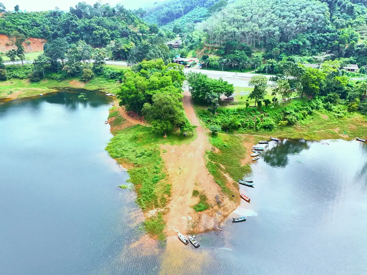
Pa Phayom Reservoir, officially known as the Pa Phayom Reservoir Royal Development Project, is an important reservoir in Ko Tao Subdistrict, Pa Phayom District, Phatthalung Province. Located around Ban Wang Len on the Pa Phayom–Khuan Din So Road, about 16 km from Phet Kasem Road, the reservoir is known for its open water scenery, mountain setting, and quiet natural atmosphere. It is suitable for travelers who want a peaceful viewpoint, a local water-resource landscape, and a deeper understanding of how reservoirs support agriculture and communities in southern Thailand.
In simple terms, Pa Phayom Reservoir is more than a scenic water body. It is a royal-initiative water-development project designed to store water, support farming, provide water for household use, serve as a freshwater fish-breeding area, offer local recreation, and help reduce flood impacts. The reservoir is not a highly commercial attraction. Its value comes from its role as working water infrastructure and from the quiet landscape formed by water, forested mountains, and rural surroundings.
The reservoir is closely connected with Khlong Pa Phayom, a local stream system that originates from the Banthat mountain range. The project was built by constructing an earth dam across the upstream section of Khlong Pa Phayom, about 15 km above Ban Phrao weir. This location allows the reservoir to act as an upstream water source, supporting irrigation and farming areas further downstream.
The background of Pa Phayom Reservoir begins with royal initiatives for water development in Phatthalung. On 14 September 1977, His Majesty King Bhumibol Adulyadej gave a royal initiative for the Royal Irrigation Department to consider reservoir and irrigation-system development along the foothills of the Banthat Range in Phatthalung. The purpose was to support farming areas near the foothills, store water for dry-season cultivation, support existing irrigation areas around the Songkhla Lake plains, and help reduce flooding impacts.
On 24 September 1981, an additional royal initiative emphasized the need to urgently develop suitable reservoirs in Phatthalung. Farming areas served by existing diversion-weir projects often faced water shortages, especially during dry spells and the dry season. A reservoir in the upstream area would help distribute water more effectively, improve farming security, and demonstrate the practical value of reservoir development for local people.
The Pa Phayom Reservoir project was implemented during the 1988 fiscal year and completed in 1992. It consists of an earth dam across Khlong Pa Phayom. The catchment area above the dam is about 24 square kilometers. The reservoir capacity is about 20.50 million cubic meters. The earth dam is 255 meters long and 33 meters high, with a spillway and outlet system that releases water back into the original stream channel downstream to support Ban Phrao weir.
The project benefits around 35,700 rai of agricultural land in the Ban Phrao irrigation project area. It supports 22 villages across 5 subdistricts: Ko Tao, Pa Bon, Ban Phrao, and Laem Tanot in Pa Phayom District, Phatthalung Province, and Khon Hat in Cha-uat District, Nakhon Si Thammarat Province. On average, it supports about 21,500 rai during the rainy-season farming period and about 4,000 rai during the dry season, with higher potential in years when water is more abundant.
For travelers, Pa Phayom Reservoir is best experienced as a quiet nature stop. Visitors can enjoy the open water, mountain backdrop, rural access road, and calm atmosphere. The site is suitable for photography, scenic viewing, short rest stops, and learning about a royal-initiative water project. It is not a destination built around rides or large tourist facilities, so visitors should approach it as a peaceful reservoir landscape and community water source.
The reservoir’s appeal lies in its simplicity. Its beauty comes from the relationship between water, forested slopes, farmland, and local livelihoods. A visit here helps travelers see how water infrastructure can support agriculture while also becoming a place for local recreation. This makes the reservoir meaningful for visitors interested in slow travel, rural landscapes, community water management, and environmental learning.
The surrounding area is also linked with natural attractions along the Banthat Range. The travel route around Pa Phayom is associated with caves, limestone formations, waterfalls, streams, and forest scenery. Travelers can use Pa Phayom Reservoir as a starting point for a broader nature trip that includes Khao Pu–Khao Ya National Park, rafting areas, waterfalls, caves, and local communities in Pa Phayom District.
For photography, the reservoir is strongest in the morning and late afternoon. Morning light gives the water and mountain scenery a calm, soft appearance, while late afternoon is suitable for reflections, sky color, and peaceful landscape images. Good subjects include the reservoir surface, the earth-dam area, the access road, the mountain backdrop, and the surrounding rural scenery. Visitors should avoid entering restricted irrigation structures or areas not intended for public access.
Pa Phayom Reservoir also functions as a useful educational site. It clearly shows how one reservoir can serve several purposes: storing water for agriculture, supporting household water needs, helping fish breeding, offering local recreation, and reducing flood impacts. For travelers who want to understand Phatthalung beyond standard sightseeing, this reservoir explains the importance of water management in a province shaped by mountains, streams, farmland, and lake plains.
The Pa Phayom–Khuan Din So Road gives the journey additional interest. The route connects local communities with the foothill landscape. Along the way, travelers can see rural scenery, agricultural land, and the gradual transition from lowland areas toward the mountain zone. A private car or rental car is the most convenient way to visit, because it also allows easy continuation to nearby attractions and restaurants.
Visitors should plan their trip according to weather and daylight. Morning is good for quiet viewing and photography, while late afternoon offers cooler air and softer light. During the rainy season, roads and reservoir-edge areas may be slippery, and water conditions can change after heavy rain. Since the site is an active water-resource area, visitors should use caution, stay in safe public areas, and avoid interfering with irrigation structures.
Responsible travel matters at Pa Phayom Reservoir. Visitors should keep the area clean, avoid littering, avoid disturbing forest and water areas, and avoid entering water in places not intended for recreation. The reservoir supports agriculture, household water use, aquatic life, and local communities, so preserving water quality and respecting the site’s primary function are essential.
Nearby attractions make the reservoir easier to include in a more complete itinerary. Khao Pu–Khao Ya National Park offers rainforest scenery, caves, waterfalls, and nature trails. Nan Mod Daeng rafting and Wang Wadee rafting provide more active water-based experiences. Wat Pa Phayom and the Pa Phayom community add local cultural context, while Tai Nod Market and Thale Noi can extend the trip into food, community life, and wetland scenery.
Khao Pu–Khao Ya National Park is one of the strongest nearby nature destinations. It is known for dense forest, large trees, caves, waterfalls, viewpoints, and humid evergreen-forest scenery. Combining the reservoir with the national park gives travelers a fuller picture of Pa Phayom’s natural setting: reservoir, mountain, forest, cave, waterfall, and watershed landscape.
Nan Mod Daeng rafting and Wang Wadee rafting are good additions for travelers who want more activity after visiting the reservoir. Both are associated with Pa Phayom’s stream-based recreation. A practical route is to visit the reservoir in the morning, then continue to rafting areas or riverside restaurants later in the day. This creates a trip that combines quiet scenery with active nature travel.
For travelers interested in local culture, Wat Pa Phayom and the Pa Phayom community are useful additions. The name Pa Phayom has local history and community meaning, and visiting the community after the reservoir helps connect the landscape with the people who live in the area. This makes the trip more complete than a simple photo stop.
Getting There is easiest by private car. From Phet Kasem Road, turn onto the Pa Phayom–Khuan Din So Road and continue for about 16 km to reach the reservoir area in Ko Tao Subdistrict, Pa Phayom District, Phatthalung. A private vehicle is recommended because it allows travelers to continue to Khao Pu–Khao Ya National Park, rafting areas, restaurants, and accommodations in Pa Phayom.
A good half-day plan is to visit Pa Phayom Reservoir in the morning, enjoy the water and mountain views, take photos, and then continue to Pa Phayom town or local restaurants. A full-day trip can combine the reservoir with Khao Pu–Khao Ya National Park, Nan Mod Daeng rafting, and a local meal. Travelers staying overnight can choose accommodation in Pa Phayom or in the rafting areas around Lan Khoi and nearby streams.
Pa Phayom Reservoir deserves a place in a Phatthalung itinerary because it combines natural scenery, royal-initiative water development, agricultural value, and local recreation. It is not only a reservoir for viewing; it is an important water-management project that supports farms, communities, aquatic life, and the broader landscape of Pa Phayom District.
| Name | Pa Phayom Reservoir / Pa Phayom Reservoir Royal Development Project |
| Location | Ban Wang Len, Ko Tao Subdistrict, Pa Phayom District, Phatthalung Province |
| Address | Ko Tao Subdistrict, Pa Phayom District, Phatthalung Province, Thailand |
| Coordinates | Approximately 7.75861, 99.75972 |
| Highlights | Royal-initiative reservoir, scenic mountain-foot landscape, open water views, and access to nearby caves, waterfalls, and nature attractions in Pa Phayom |
| History | Royal initiatives were given on 14 September 1977 and 24 September 1981. The project was implemented in the 1988 fiscal year and completed in 1992 |
| Distinctive Features | Earth dam across Khlong Pa Phayom, wide reservoir, mountain backdrop, and strong agricultural water-management role |
| Project Details | Catchment area about 24 square kilometers; storage capacity about 20.50 million cubic meters; earth dam length 255 meters; dam height 33 meters |
| Main Benefits | Supports about 35,700 rai of agricultural land in the Ban Phrao project area; provides water for farming, household use, fish breeding, recreation, and flood mitigation |
| Travel Information | Located on the Pa Phayom–Khuan Din So Road, about 16 km from Phet Kasem Road; best reached by private car |
| Current Status | Open as an irrigation reservoir, local recreation area, and scenic viewpoint in Ko Tao Subdistrict, Pa Phayom District |
| Open Days | Daily |
| Opening Hours | 08:00 – 17:00 |
| Facilities | Access road, reservoir viewpoints, resting areas, and connections to nearby nature attractions |
| Main Areas / Zones | Earth-dam area, reservoir surface, viewpoint area, spillway structure, and reservoir access route |
| Caretaker | Royal Irrigation Department, Ministry of Agriculture and Cooperatives |
| Nearby Tourist Attractions | 1. Khao Pu–Khao Ya National Park, about 15 km 2. Nan Mod Daeng Rafting, about 18 km 3. Wang Wadee Rafting, about 18 km 4. Wat Pa Phayom, about 20 km 5. Tai Nod Market, about 30 km 6. Thale Noi, about 36 km |
| Nearby Restaurants | 1. Ruen Offroad Phatthalung, about 17 km, Tel. 081-638-7800 2. The Landmark Cafe & Restaurant, about 20 km, Tel. 086-274-5774 3. Dok Phayom Restaurant, about 20 km, Tel. 094-430-0222 4. Krua Indy Pa Phayom, about 20 km, Tel. 090-180-8070 5. Anueng Bar, about 21 km, Tel. 095-090-4494 |
| Nearby Accommodations | 1. Pa Phayom Resort Phatthalung, about 18 km, Tel. 081-816-1435 2. S.K. Park Hotel, about 20 km, Tel. 074-820-345 3. Yadfah Village Hotel, about 21 km, Tel. 065-927-5886 4. Baan Rim Nam Homestay Phatthalung, about 22 km, Tel. 081-087-1427 5. Teng 1 Resort Pa Phayom, about 22 km, Tel. 086-292-3527 |
Frequently Asked Questions (FAQ)
Q: Where is Pa Phayom Reservoir located?
A: Pa Phayom Reservoir is located around Ban Wang Len, Ko Tao Subdistrict, Pa Phayom District, Phatthalung Province, on the Pa Phayom–Khuan Din So Road.
Q: Why is Pa Phayom Reservoir important?
A: It is a royal-initiative reservoir that supports agriculture, household water use, fish breeding, local recreation, and flood mitigation in the Ban Phrao project area.
Q: What are the coordinates of Pa Phayom Reservoir?
A: The approximate coordinates are 7.75861, 99.75972 in Ko Tao Subdistrict, Pa Phayom District, Phatthalung Province.
Q: What type of trip is Pa Phayom Reservoir suitable for?
A: It is suitable for scenic viewing, photography, quiet relaxation, and learning about a royal-initiative water-resource project.
Q: How do travelers get to Pa Phayom Reservoir?
A: From Phet Kasem Road, turn onto the Pa Phayom–Khuan Din So Road and continue about 16 km to the reservoir area. A private car is the most convenient option.
Q: What attractions are near Pa Phayom Reservoir?
A: Nearby attractions include Khao Pu–Khao Ya National Park, Nan Mod Daeng Rafting, Wang Wadee Rafting, Wat Pa Phayom, Tai Nod Market, and Thale Noi.
Q: When is the best time to visit Pa Phayom Reservoir?
A: Morning and late afternoon are the best times because the weather is more comfortable, the light is softer, and the reservoir and mountain views are clearer.
Q: What should visitors be careful about?
A: Visitors should stay in safe public areas, avoid restricted irrigation structures, avoid littering, and avoid entering water areas not intended for recreation.
 Category: ●Nature and Wildlife
 Group: ●Dam, Reservoir, Lake
Last Update : 2 MonthAgo
 Last Update : 2 MonthAgo
 Click to Access the Navigation Map GPS
Pa Phayom Reservoir Map
Recommend

 Art, Culture and Heritage
 Historical Sites and Monuments(1)
 Landmarks and Memorials(1)
 Art, Craft Centres, Tradition(6)
 Historic Homes and Cities(1)
 Educational Places
 Educational Gardens, Farm(1)
 Places of Worship
 Temple(25)
 Other Sacred Sites(4)
 Research and Development
 Royal Project(2)
 Suburban Living
 Village, Community(3)
 National Parks and Marine Reserves(3)
 Mountain (Doi)(4)
Dam, Reservoir, Lake(7)
 Waterfalls(16)
 Hot Springs(2)
 Caves(12)
 River, Canal(5)
 Bays and Beaches(6)
 Islands(2)
 Other natural attractions(4)
 Entertainment and Agricultural
 Farms, Parks and Ecotourism(4)
 Travel Articles, Recipes
 Travel Review, Food Review(1)


