
lovethailand home >South Travel Attractions >Chumphon Travel Attractions >Thung Tako >Tako > Khlong Phrao National Park
TL;DR: Khlong Phrao National Park is located at Tako Subdistrict, Thung Tako District, Chumphon 86220, Thailand, open Daily, hours 06.00 - 18.00.
Khlong Phrao National Park
Open Days: Daily
Opening Hours: 06.00 - 18.00
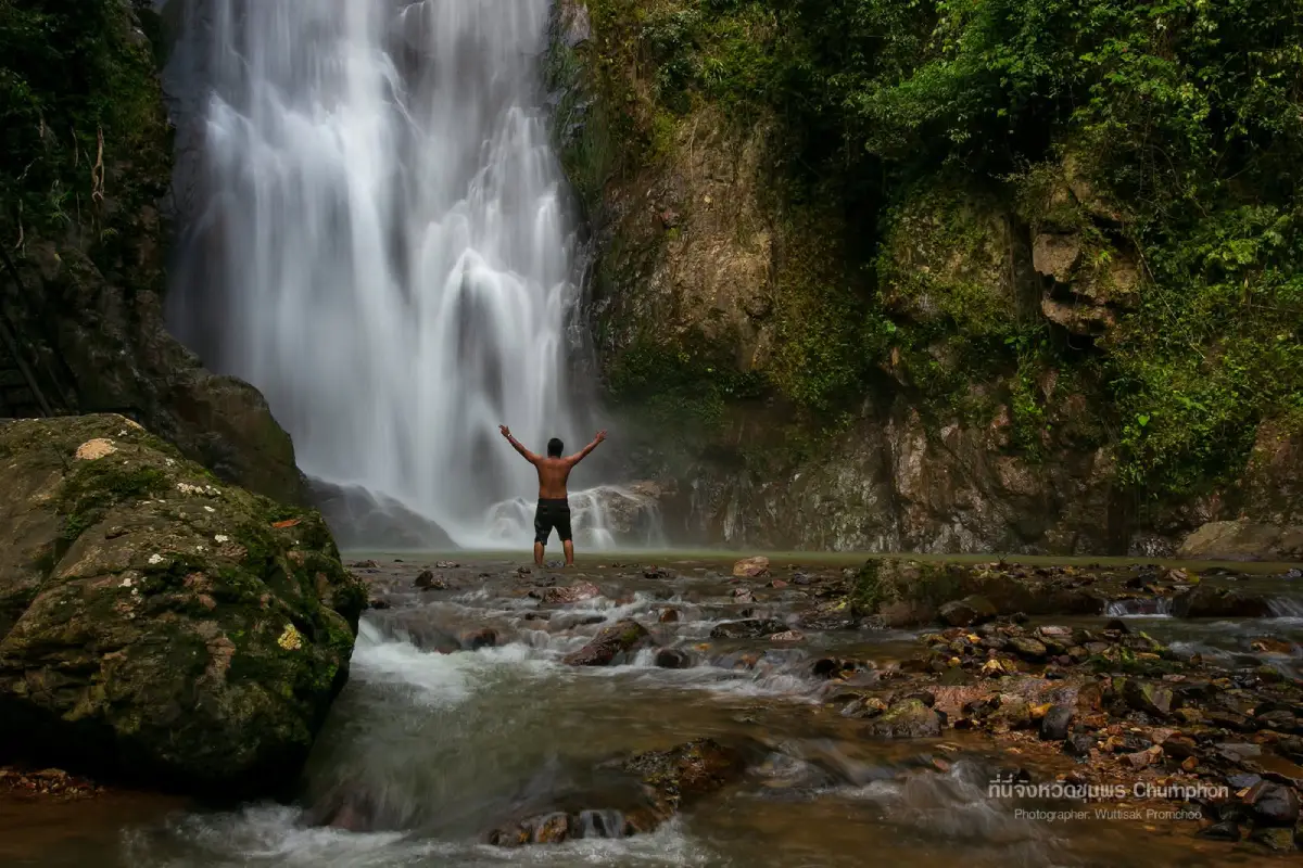
Khlong Phrao National Park is the former name of the protected area now officially known as Namtok Ngao National Park. The park spans forested mountain areas across Ranong and Chumphon Provinces. On the Chumphon side, the key attraction is Khlong Phrao Waterfall, also known as Thap Chang Waterfall, located in Tako Subdistrict, Thung Tako District. It is a large forest waterfall with year-round water flow, multiple tiers, and a dramatic third tier where water drops from a rocky cliff into a clear, cool pool. The area is suitable for nature travelers who want waterfall trekking, safe water play, forest photography, camping, and a deeper experience of southern Thailand’s humid evergreen forest. From Pathomphon Intersection, take Highway 41 south toward Thung Tako and Lang Suan, then turn toward Ban Mueang Nai Kut and continue to Namtok Ngao National Park Ranger Unit No. 1, Khlong Phrao Waterfall.
Khlong Phrao National Park appears in older Chumphon travel information as a protected area being prepared for national park declaration. In the present national park system, this area is known as Namtok Ngao National Park. The name Khlong Phrao remains important because Khlong Phrao Waterfall is still one of the main natural attractions on the Chumphon side of the park. For clarity, modern travel content should explain both names: Khlong Phrao as the older name and Namtok Ngao as the current official national park name.
The park is important because it protects a large forested mountain landscape linking Ranong and Chumphon. The terrain is complex, with north-south mountain ranges, humid evergreen forest, headwaters, streams, waterfalls, and wildlife habitats. Ranong is best known for Namtok Ngao, the park’s major landmark waterfall, while Chumphon is represented by Khlong Phrao Waterfall in Thung Tako District. This makes the park a cross-provincial conservation landscape rather than a single waterfall attraction.
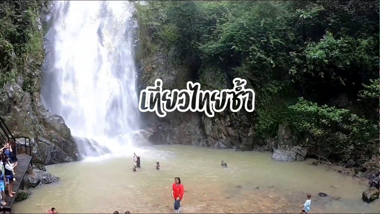
Khlong Phrao Waterfall, or Thap Chang Waterfall, is a large forest waterfall in Thung Tako District. Its main appeal is year-round water and a multi-tiered structure. The route is unusual because visitors begin from the ranger unit and walk down toward the lower waterfall area, then experience the waterfall from the lower tiers upward or according to the current trail conditions. The descent may feel easier, but the return requires uphill walking, so visitors should consider their fitness before going down.
The most famous section is the third tier. Here, the water falls from a high rocky cliff, hits the rocks below, and creates mist around the pool. The combination of cliff, falling water, green forest, and clear pool makes this the strongest scenic point of the waterfall. It is also one of the best areas for photography and rest, provided visitors remain in safe areas and follow local guidance.
Khlong Phrao is beautiful, but it is not a highly developed urban-style attraction. Around the ranger unit, facilities are limited. There is a camping ground, but no full-service restaurants, resorts, or dense tourist infrastructure. Visitors who want to stay overnight must bring camping equipment, food, drinking water, lighting, medicine, and personal supplies. This place is best suited to nature travelers who can prepare and take care of themselves responsibly.
The route to Khlong Phrao used to be difficult and was once known among more adventurous travelers. Access is easier today, but parts of the route can still be steep, winding, or unpaved near the ranger unit. Drivers should use a vehicle in good condition, avoid speeding, and travel during daylight. Before going, it is wise to check route conditions with local authorities or the park, especially during the rainy season.
The surrounding ecosystem is humid evergreen forest. Tall trees, ferns, mosses, vines, streamside plants, and constant moisture create a cool forest atmosphere. The sound of flowing water, insects, and birds makes the area suitable for quiet nature observation. Photographers can capture waterfalls, boulders, pools, forest greenery, and mist from the falling water.
Swimming or water play is possible only in suitable areas and safe conditions. Visitors must be careful of slippery rocks, deep pools, changing water levels, and sudden upstream rain. Do not jump from rocks, enter unknown deep water, or continue swimming during heavy rain, cloudy water, or signs of flash flooding. Safety and park guidance should always come before convenience.
The waterfall can be visited as a half-day or full-day nature trip. Visitors who only want to see the waterfall and rest should allow at least 2 to 3 hours, including the walk down, time at the waterfall, and the return climb. Those who want to photograph several tiers or explore more slowly should start in the morning. Entering the waterfall trail late in the day is not recommended because forest routes become more difficult after dark.
Getting There from Pathomphon Intersection uses Highway 41, the Chumphon-Surat Thani route, for about 55 km toward Thung Tako and Lang Suan. Turn right around kilometre markers 57-58 toward Ban Mueang Nai Kut, continue for about 12-14 km, then follow the later unpaved section for about 1-3 km to Namtok Ngao National Park Ranger Unit No. 1, Khlong Phrao Waterfall. The exact distance may vary by starting point and current route conditions, so visitors should check maps and local updates before traveling.
Older travel information describes the route from Pathomphon Intersection to Highway 41 for about 55 km, then turning right near kilometre marker 57 opposite the entrance to Ban Nam Chuet for another 15 km. More recent local tourism information describes a similar approach around kilometre markers 57-58 with access through Ban Mueang Nai Kut. The core route remains Highway 41, but current signage and side-road conditions should be checked before travel.
Older information about Khlong Phrao National Park also mentions other attractions such as Khlong Phrao Waterfall, Tham Than Lot Yai, Tham Than Lot Lek, and Thai Mueang Waterfall. In current visitor planning, Khlong Phrao Waterfall is the most clearly documented Chumphon-side destination. Other names should be treated carefully unless current access and location information can be confirmed directly with the park or local authorities.
The best season depends on rainfall and safety. After rain, the forest is lush and the waterfall is powerful, but the trail may be slippery and flash-flood risk can increase. During drier months, the waterfall still has water, but the flow may be gentler. Visitors should avoid traveling during heavy-rain warnings, unstable weather, or poor road conditions.
Essential preparation includes non-slip footwear, quick-drying clothes, a towel, drinking water, light food, personal medicine, waterproof bags for electronics, a flashlight, and a personal trash bag. Campers must also bring tents, sleeping mats, bedding, cooking equipment, and all necessary supplies because food and accommodation services are limited in the area.
Responsible travel is essential inside the national park. Do not collect plants, disturb animals, litter, use soap or shampoo in streams, make loud noise, light fires outside permitted areas, or remove natural objects from the park. Everything brought into the forest should be taken back out. The waterfall’s beauty depends on low-impact visitor behaviour.
Khlong Phrao can be combined with nearby destinations in Thung Tako and surrounding districts, such as Suan Nai Dam, Wat Phra Borommathat Sawi, Arunothai Beach, Pak Tako, Ao Lok Kam, and Lang Suan town. A practical plan is to visit Khlong Phrao in the morning, return to Thung Tako for food in the afternoon, and continue to a coastal or cultural attraction if time allows.
Overall, the former Khlong Phrao National Park and the current Namtok Ngao National Park represent one of the most important forest conservation landscapes between Ranong and Chumphon. On the Chumphon side, Khlong Phrao Waterfall or Thap Chang Waterfall expresses that value clearly through year-round water, forested cliffs, cool pools, and a serious natural setting. A visit here is not just a quick waterfall stop; it is a chance to enter a living humid forest that requires preparation, respect, and environmental responsibility.
| Name | Khlong Phrao National Park / Currently Namtok Ngao National Park / Khlong Phrao Waterfall Or Thap Chang Waterfall |
| Main Chumphon-Side Location | Namtok Ngao National Park Ranger Unit No. 1, Khlong Phrao Waterfall, Tako Subdistrict, Thung Tako District, Chumphon Province |
| Address | Tako Subdistrict, Thung Tako District, Chumphon 86220, Thailand |
| Current National Park Area | Namtok Ngao National Park Covers Ranong And Chumphon Provinces, About 417,500 Rai Or 668 Square Kilometres |
| Contact Numbers | Namtok Ngao National Park, Tel. 077-848-181 Department Of National Parks, Wildlife And Plant Conservation, Tel. 02-562-0760 |
| Highlights | Khlong Phrao Or Thap Chang Waterfall, A Multi-Tier Forest Waterfall With Year-Round Water Flow; The Third Tier Is The Main Scenic Point, Where Water Drops From A Rocky Cliff Into A Clear Pool |
| Distinctive Features | Humid Evergreen Forest, Complex Mountain Terrain, Valley Waterfall, Nature Trail, Natural Pools, And Self-Prepared Camping Area |
| Place Category | National Park, Waterfall, Nature Attraction, Camping Area, And Humid Evergreen Forest Learning Site |
| Open Days | Daily |
| Opening Hours | 06.00 - 18.00 |
| Entrance Fee | Thai Visitors: Adult 20 Baht, Child 10 Baht Foreign Visitors: Adult 100 Baht, Child 50 Baht Vehicle Fees And Other Service Fees Follow National Park Regulations |
| Travel Information | From Pathomphon Intersection, take Highway 41 for about 55 km. Turn right around kilometre markers 57-58 toward Ban Mueang Nai Kut for about 12-14 km, then continue on an unpaved section for about 1-3 km to Namtok Ngao National Park Ranger Unit No. 1, Khlong Phrao Waterfall. |
| Current Status | The Former Khlong Phrao National Park Area Is Now Under Namtok Ngao National Park, While Khlong Phrao Waterfall Remains A Key Chumphon-Side Attraction |
| Main Areas / Zones | 1. Namtok Ngao National Park Ranger Unit No. 1, Khlong Phrao Waterfall 2. Trail Down To The Waterfall 3. Khlong Phrao Waterfall Tiers 4. Third-Tier Viewpoint And Natural Pool 5. Camping Area 6. Humid Evergreen Forest And Stream Area 7. Route Through Ban Mueang Nai Kut |
| Recommended Activities | Waterfall Walking, Safe Water Play, Nature Photography, Short Forest Walks, Camping, Humid Evergreen Forest Study, And Quiet Nature Resting |
| Visitor Guidelines | Check Road Conditions Before Traveling, Prepare Food And Equipment, Beware Of Steep And Slippery Trails, Avoid Swimming During Heavy Rain, Do Not Litter, Do Not Use Soap Or Shampoo In Streams, And Follow Park Officer Instructions |
| Nearby Tourist Attractions | 1. Suan Nai Dam, About 25 km 2. Wat Phra Borommathat Sawi, About 28 km 3. Arunothai Beach, About 35 km 4. Pak Tako, About 35 km 5. Ao Lok Kam, About 38 km 6. Lang Suan Town, About 35 km |
| Nearby Restaurants | 1. Krua Suan Nai Dam, About 25 km, Tel. 089-652-0733 To 089-652-0735 2. Sathani Suvarnabhumi, About 25 km, Tel. 091-735-7678, 077-975-978 3. Rim Nam Restaurant, Pak Tako, About 35 km, Tel. 087-278-2905 4. Pak Tako Seafood, About 35 km, Tel. 077-579-044 5. PunThai Coffee Thung Tako 1, About 25 km, Tel. 061-394-8320 |
| Nearby Accommodations | 1. Ranger Unit No. 1 Camping Area, Inside Khlong Phrao Waterfall Area 2. Thung Tako Resort 1, About 25 km, Tel. 098-205-6355 3. Jitra Resort Chumphon, About 25 km, Tel. 086-277-1739 4. Aten Hotel, About 25 km, Tel. 064-678-6666 5. Tusita Resort & Spa, About 35 km, Tel. 077-579-073, 077-579-074, 077-579-151 6. Accommodation Around Lang Suan District, About 35 km |
Frequently Asked Questions (FAQ)
Q: Is Khlong Phrao National Park Still The Official Name?
A: Khlong Phrao is the former name. The current official national park name is Namtok Ngao National Park, while Khlong Phrao Waterfall remains a key attraction on the Chumphon side.
Q: Where Is Khlong Phrao Waterfall Located?
A: It is located in Tako Subdistrict, Thung Tako District, Chumphon Province, within Namtok Ngao National Park and under Ranger Unit No. 1.
Q: What Are The Opening Days And Hours?
A: It is open daily from 06.00 to 18.00, but visitors should check weather and road conditions before traveling, especially during heavy rain.
Q: How Much Is The Entrance Fee?
A: Thai visitors pay 20 baht for adults and 10 baht for children. Foreign visitors pay 100 baht for adults and 50 baht for children. Vehicle and other service fees follow national park regulations.
Q: What Is The Main Highlight Of Khlong Phrao Waterfall?
A: The highlight is the multi-tier forest waterfall with year-round water flow. The third tier is especially scenic, with water dropping from a rocky cliff into a clear natural pool.
Q: Are There Accommodation Or Restaurants At Khlong Phrao Waterfall?
A: The ranger unit has a camping area, but there are no full-service restaurants or resort-style facilities. Overnight visitors must bring their own camping gear and food.
Q: How Do Travelers Get There?
A: From Pathomphon Intersection, take Highway 41 south toward Thung Tako and Lang Suan, turn right around kilometre markers 57-58 toward Ban Mueang Nai Kut, and continue to Ranger Unit No. 1.
Q: What Should Visitors Prepare?
A: Visitors should prepare non-slip shoes, quick-drying clothes, drinking water, food, medicine, waterproof bags, a flashlight, and a trash bag. Campers must bring all overnight equipment.
 Category: ●Nature and Wildlife
 Group: ●National Parks and Marine Reserves
Last Update : 2 MonthAgo
 Last Update : 2 MonthAgo
 Click to Access the Navigation Map GPS
Khlong Phrao National Park Map
Recommend

 Art, Culture and Heritage
 Historical Sites and Monuments(1)
 Landmarks and Memorials(2)
 Art, Craft Centres, Tradition(3)
 Museums(2)
 Educational Places
 Educational Gardens, Farm(1)
 Places of Worship
 Temple(31)
 Other Sacred Sites(10)
 Research and Development
 Royal Project(1)
 Suburban Living
 Village, Community(5)
 Local Market(1)
National Parks and Marine Reserves(7)
 Mountain (Doi)(5)
 Dam, Reservoir, Lake(1)
 Waterfalls(26)
 Hot Springs(1)
 Caves(21)
 River, Canal(7)
 Bays and Beaches(30)
 Islands(13)
 Other natural attractions(7)
 Entertainment and Agricultural
 Farms, Parks and Ecotourism(3)
 Outdoor and Adventure Activities(4)
 Shopping
 Shopping and Night Market(1)
 Travel Articles, Recipes
 Travel Review, Food Review(1)


