
lovethailand home >Northeastern Travel Attractions >Yasothon Travel Attractions >Kham Khuan Kaeo >Song Pueai > Don Mueang Toei Archaeological Site
TL;DR: Don Mueang Toei Archaeological Site is located at Village No. 8, Song Pueai Subdistrict, Kham Khuean Kaeo District, Yasothon Province, open Daily, hours 08.00 – 17.00.
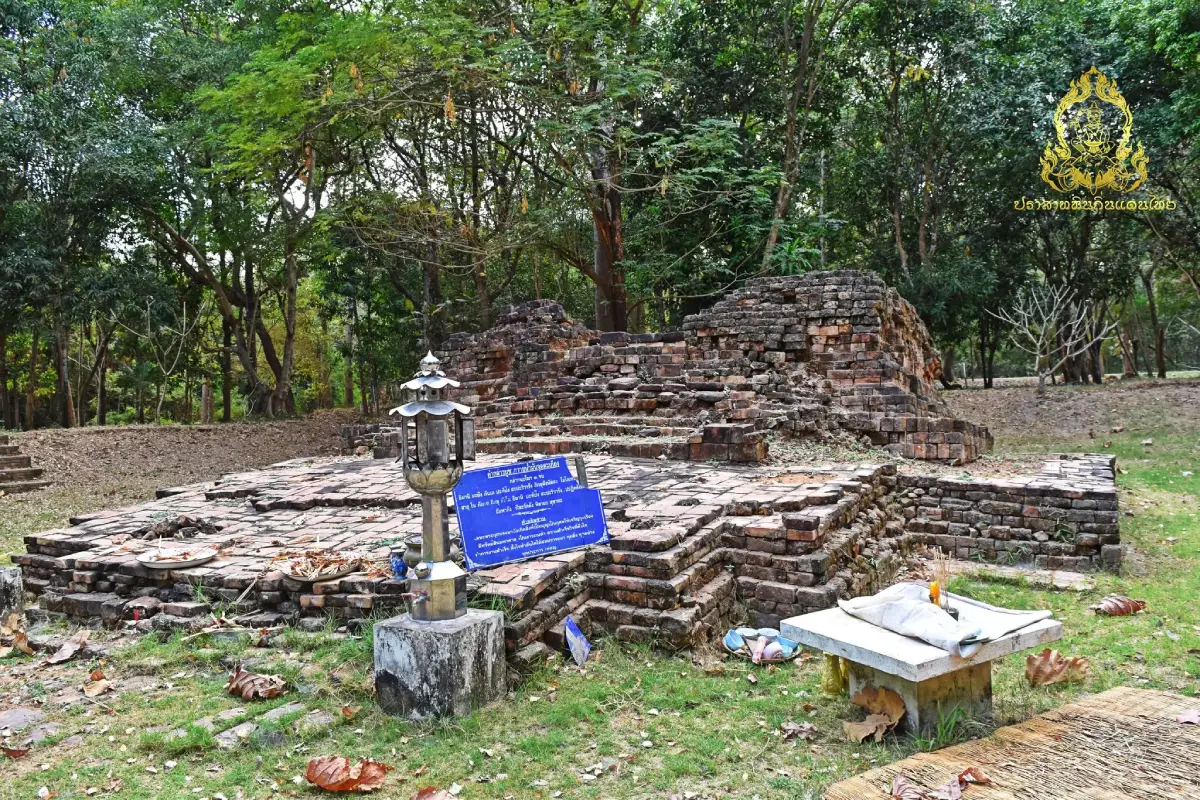
Don Mueang Toei Archaeological Site
Open Days: Daily
Opening Hours: 08.00 – 17.00
Don Mueang Toei Ancient Monument in Yasothon Province is an important archaeological and religious site within Dong Mueang Toei Ancient Community, Ban Song Pueai, Song Pueai Subdistrict, Kham Khuean Kaeo District. The area preserves evidence of settlement from the late prehistoric period, around 2,500 years ago, through the Dvaravati period, Chenla influence, and early Khmer culture. Its key features include an oval ancient mound, a single moat-and-embankment system, a brick religious structure without mortar, a Pallava-script Sanskrit inscription, and evidence of a Shaivite Hindu sanctuary that was later reused in a Buddhist context. The site is open daily, has no admission fee, and is suitable for travelers interested in archaeology, Isan history, Chenla civilization, and cultural routes in Yasothon.
Don Mueang Toei Ancient Monument, also known as Dong Mueang Toei Ancient Monument, is located within Dong Mueang Toei Ancient Community in Ban Song Pueai, Song Pueai Subdistrict, Kham Khuean Kaeo District, Yasothon Province. It is one of the most important archaeological sites in the lower northeastern region of Thailand because it preserves evidence of human settlement across several historical layers. The site reflects the development of a community from a late prehistoric agricultural and iron-producing settlement into an early urban community influenced by Dvaravati culture, Chenla civilization, and early Khmer religious traditions. Don Mueang Toei is therefore not merely an old brick base; it is a key piece of evidence for understanding society, religion, economy, and political-cultural networks in the Chi River basin over more than 2,000 years.
The site is about 0.5 kilometers from Ban Song Pueai village and about 5.5 kilometers from Kham Khuean Kaeo District center. It can be reached by the paved rural road from Kham Khuean Kaeo to Song Pueai, a distance of about 5.5 kilometers, or by the paved road from the Chaeng Sanit Road junction on the Kham Khuean Kaeo – Yasothon route, a distance of about 5 kilometers. From Yasothon city, travelers can take Highway 23, also known as Chaeng Sanit Road, south toward Song Pueai Subdistrict and Kham Khuean Kaeo District for about 20 kilometers, then turn toward Ban Song Pueai and continue through the village road to Dong Mueang Toei Monastic Area. The ancient monument stands on the eastern side of the ancient mound.
The landscape of Don Mueang Toei is a slightly oval earthen mound. Its longer diameter runs from the northeast to the southwest for about 650 meters, while the northwest-southeast axis measures about 450 to 540 meters. The ancient town was surrounded by a single moat-and-embankment system, with natural and man-made water features around it. To the north were Nong Bua Khao and Nong A Liu; to the south were Nong Pu Ta and Nong I Tu; to the east were Nong Toei and Nong Rong Wua; and to the west were Nong Fak Nam, Nong Mak Dik, Nong Ben, Nong Bua, and Nong Mon. Today, some sections of the moat are still visible, while others have been modified into rice fields and agricultural land by the local community.
The single moat and embankment around the ancient settlement show how closely the community was connected to water management and agriculture. Dong Mueang Toei was located on a low river terrace near the Chi River, Lam Chi Long, and Nong Fak Nam. The surrounding land was suitable for rice cultivation, while nearby water sources supported long-term habitation. The moat and embankment did more than mark the settlement boundary. They also helped manage water, define sacred and communal space, and reflect the emergence of a more organized society with leadership and social hierarchy.
Archaeological evidence shows that Dong Mueang Toei was occupied from the late prehistoric period, about 2,500 years ago. The earliest settlement phase was related to rice cultivation, daily-use pottery, and iron production. The large quantity of iron slag found within the community indicates that this area played an important role in iron production or iron use in the Mun and Chi river basins. Before entering the early historic period, the community had contact with other communities in northeastern Thailand, as shown by pottery fragments related to Thung Kula Rong Hai and Roi Et-style ceramic traditions.
Around the 12th to 13th Buddhist centuries, Dong Mueang Toei developed into a more complex urban community with leadership, governance, and a religious center. This was the period when the community was strongly influenced by Chenla and early Khmer culture. The people of the ancient city primarily followed Shaivite Hinduism, and the inscription refers to the creation or dedication of a sacred linga associated with Lord Shiva. Don Mueang Toei is therefore interpreted as a Shaivite religious monument, with architectural forms influenced by pre-Angkorian Khmer art.
The Don Mueang Toei inscription is one of the most important pieces of evidence from the site. It is a sandstone inscription written in Pallava script and Sanskrit, dating to around the 12th Buddhist century. The inscription is associated with elite figures and a religious dedication connected with Shiva. Scholars have linked Dong Mueang Toei with the name Sankhapura, a settlement within the Chenla cultural network. The presence of Sanskrit and Pallava script in this area shows that Don Mueang Toei was not an isolated rural settlement. It was a community that received strong cultural influence from the Indianized world through Chenla and early Khmer civilization.
Today, the ancient monument remains mainly as a brick architectural base without mortar. It stands on the eastern side of Dong Mueang Toei Ancient City, within the area of Dong Mueang Toei Monastic Community. The surviving structure has a rectangular plan and is about 1.7 meters high, approximately 5 meters wide and 5.5 meters long. Its base consists of several stepped tiers and decorative mouldings, including lower bands, inverted lotus mouldings, recessed panels, upright lotus mouldings, and upper bands. The architectural details reflect an early religious-building tradition influenced by late Gupta and post-Gupta Indian art as well as pre-Angkorian Khmer forms.
The lowest tier of the base is larger than the upper tiers and projects toward the east. The first tier measures about 9 by 12.5 meters, the second tier about 7 by 8 meters, and the third and fourth tiers about 6 by 6 meters. The recessed panels contain small square motifs arranged in 3 layers, with visible remains on some sides of the structure, especially the north and west. These details make Don Mueang Toei an important example of an early religious architectural base in northeastern Thailand.
On the eastern side of the structure are traces of a staircase and a brick platform. A walkway extends from the front of the monument for about 28 meters, and the area around the structure contains brick paving. The east-facing orientation follows a pattern common in many early religious monuments influenced by Indian and Southeast Asian traditions. When considered together with the inscription, references to a linga, and the structure’s sacred layout, the building clearly functioned as a ritual space rather than an ordinary community building.
Excavation and conservation work by the Fine Arts Department revealed further information about the monument. In 1983, the first excavation found red sandstone steps, brick alignments, Khmer pottery fragments, and a fragment of green sandstone sculpture. In 1991, further excavation and stabilization work clarified the form of the base, brick courtyard, walkway, and surrounding cultural layers. Archaeological testing around the monument helped identify multiple phases of human activity, making Don Mueang Toei a major source of evidence for the development of ancient communities in the Chi River basin.
Around the 14th to 15th Buddhist centuries, the Dong Mueang Toei community began to adopt Buddhism. Evidence includes stone sema boundary markers found both around the monument and in other parts of the ancient city. The presence of sema stones near a former Hindu sacred site suggests that earlier sacred space was adapted into a new religious context. Rather than abandoning the old sacred area, the community continued to use and reinterpret it according to changing beliefs. This layering of Hindu and Buddhist traditions is one of the most important characteristics of early historic communities in northeastern Thailand.
During the 16th to 17th Buddhist centuries, Khmer cultural influence became stronger. The monument continued to serve as a central sacred space, and a freestanding lion sculpture in Baphuon-style Khmer art was found in the area. This evidence confirms that Dong Mueang Toei remained part of the Khmer cultural network after the earlier Chenla phase. After the middle of the 17th Buddhist century, evidence of habitation became less clear, and after the 18th Buddhist century the ancient city and its monument were abandoned. The area was later reused again around the 20th to 22nd Buddhist centuries.
The name Dong Mueang Toei is connected with the old landscape of forest and pandan-like plants that once grew around the area. Local elders from Ban Song Pueai recalled that the site was once a dense wooded area with large trees such as yang, tabaek, and yang hiang. The forest was associated with a local guardian spirit known as Pu Ta, and villagers avoided cutting trees there. This belief helped protect the forest and its natural resources for a time before some surrounding areas were later converted into rice fields, gardens, and farmland.
The value of Don Mueang Toei is not based only on the size of its remaining structure. Its importance lies in the way it tells the story of a community’s development from an agricultural village into an ancient town with leadership, sacred architecture, inscriptions, and regional cultural connections. The site shows that the Chi River basin was not a historical margin, but a dynamic cultural zone that received and adapted influences from Dvaravati, Chenla, and early Khmer traditions while maintaining its own local character.
For travelers, Don Mueang Toei is best visited as a learning site rather than a quick photo stop. Visitors should first observe the overall landscape: the ancient mound, the moat-and-embankment traces, the surrounding water bodies, and the monastic area. Then they can move to the brick religious structure and look carefully at the orientation, base tiers, decorative mouldings, staircase area, and brick courtyard. When these elements are understood together, the site becomes much more meaningful because every part of the landscape relates to settlement, religion, and the organization of the ancient city.
Don Mueang Toei can be combined with Wat Song Pueai and the Ban Song Pueai Antiquities Museum. These 3 places are closely connected. Wat Song Pueai preserves a large Buddha image, a stupa containing soil from the 4 Buddhist holy places, and a replica Buddha footprint. The antiquities museum collects objects found from Dong Mueang Toei. The ancient monument itself is the original archaeological landscape of the former city and sacred site. Visiting them together allows travelers to see living faith, museum interpretation, and the archaeological landscape in a single route.
The atmosphere of Don Mueang Toei is quiet, rural, and not crowded. The site is surrounded by local villages, rice fields, water features, forested areas, and the monastic compound. It suits travelers who prefer historical places that are not commercialized. Visitors should bring drinking water, a hat, or an umbrella, especially during midday. Morning and late afternoon are the best times to visit because the light is softer, the weather is more comfortable, and the brick base and ancient landscape can be seen more clearly.
Visitors should treat the site with respect because Don Mueang Toei is both a registered ancient monument and a sacred place in local memory. Do not climb on the structure, move bricks, stones, sema stones, or archaeological fragments, write on the monument, leave rubbish, or disturb the monastic area. Responsible travel helps protect the site and allows future generations to continue learning from the real archaeological landscape.
Getting There to Don Mueang Toei can be done from Kham Khuean Kaeo District by taking the paved Kham Khuean Kaeo – Song Pueai road for about 5.5 kilometers, or from the Chaeng Sanit Road junction on the Kham Khuean Kaeo – Yasothon route for about 5 kilometers. From Yasothon city, take Highway 23 toward Kham Khuean Kaeo District and Song Pueai Subdistrict for about 20 to 25 kilometers, then turn into Ban Song Pueai and follow the village road to Dong Mueang Toei Monastic Area. The route is suitable for private cars, rental cars, and local hired vehicles.
Travelers should allow at least 1 to 2 hours for Don Mueang Toei alone, and half a day if combining the visit with Wat Song Pueai, the Ban Song Pueai Antiquities Museum, the large Buddha image, the replica Buddha footprint, and other nearby attractions along the Kham Khuean Kaeo route. This destination is ideal for travelers who want a deeper understanding of Yasothon’s historical roots, as it brings together ancient civilization, sacred architecture, local art, and rural Isan community life in one route.
Don Mueang Toei Ancient Monument is therefore one of Yasothon’s most important destinations for archaeology and local history. The site brings together an ancient city plan, moat and embankment, surrounding water system, brick religious base, Pallava-script Sanskrit inscription, iron-production evidence, multi-period pottery fragments, sema stones, and local oral traditions. Visitors can see how a small community in Kham Khuean Kaeo District once played a meaningful role in regional history. Don Mueang Toei deserves to be visited, studied, and preserved as an important cultural heritage site of the Chi River basin and the lower Northeast of Thailand.
| Name | Don Mueang Toei Ancient Monument |
| Related Names | Dong Mueang Toei, Dong Mueang Toei Ancient Monument, Dong Mueang Toei Ancient Community, Dong Mueang Toei Ancient City, Don Mueang Toei, Sankhapura |
| Location | Village No. 8, Song Pueai Subdistrict, Kham Khuean Kaeo District, Yasothon Province |
| Address | Song Pueai Subdistrict, Kham Khuean Kaeo District, Yasothon Province 35110, Thailand |
| Coordinates | Dong Mueang Toei Ancient Monument: 15.63972, 104.258188 Dong Mueang Toei Ancient Community: 15.639465, 104.256903 |
| Highlights | Brick religious structure without mortar, single moat-and-embankment ancient city, Pallava-script Sanskrit inscription, and evidence of a Shaivite sanctuary linked to Chenla and early Khmer culture |
| History | Occupied since the late prehistoric period around 2,500 years ago, continuing through the Dvaravati period, Chenla influence, early Khmer culture, Sambor Prei Kuk style, Baphuon style, and later reuse during the 20th to 22nd Buddhist centuries |
| Key Evidence | Pallava-script Sanskrit inscription, brick religious base, Thung Kula-style pottery, Dvaravati and Khmer pottery fragments, iron slag, sema stones, sculpture fragments, moat, and embankment remains |
| Name Origin | The name Dong Mueang Toei is connected with the old forested area where pandan-like plants once grew, while the name Sankhapura relates to the interpretation of the ancient city within the Chenla cultural context. |
| Distinctive Features | Slightly oval ancient mound, about 650 meters long and 450 to 540 meters wide, with a single surrounding moat and embankment and multiple water features around the city |
| Main Areas / Zones | 1. Don Mueang Toei Ancient Brick Base On The Eastern Side Of The Mound 2. Dong Mueang Toei Monastic Area 3. Dong Mueang Toei Ancient Mound 4. Moat And Embankment Around The Ancient City 5. Nong Pu Ta, Nong I Tu, Nong Fak Nam, Nong Toei, Nong Bua Khao, And Surrounding Water Features 6. Sema Stone And Sacred-Site Area 7. Route Linking Ban Song Pueai, Wat Song Pueai, And Ban Song Pueai Antiquities Museum |
| Caretaker | Fine Arts Department, Dong Mueang Toei Monastic Community, And Song Pueai Subdistrict Administrative Organization |
| Registration | The Fine Arts Department registered Dong Mueang Toei Ancient Monument twice: as a national ancient monument on September 27, 1936, and with an officially defined protected land area on May 10, 2004. |
| Travel Information | From Kham Khuean Kaeo District, take the paved Kham Khuean Kaeo – Song Pueai road for about 5.5 km, or use the paved road from the Chaeng Sanit Road junction on the Kham Khuean Kaeo – Yasothon route for about 5 km. From Yasothon city, take Highway 23 toward Song Pueai Subdistrict, then continue through Ban Song Pueai to Dong Mueang Toei Monastic Area. |
| Current Status | Open to visitors as a cultural tourism site and archaeological learning area in Kham Khuean Kaeo District, Yasothon Province |
| Open Days | Daily |
| Opening Hours | 08.00 – 17.00 |
| Fees | No Admission Fee |
| Facilities | Parking area near Dong Mueang Toei Monastic Area, access road from Ban Song Pueai, resting area within the monastic compound, local community roads, and restaurants in Kham Khuean Kaeo District |
| Main Contact Number | Song Pueai Subdistrict Administrative Organization Tel. 043-292-047 |
| Official Website / Official Page | Song Pueai Subdistrict Administrative Organization: songpuai.go.th |
| Nearby Tourist Attractions | 1. Dong Mueang Toei Monastic Area, within the same area 2. Wat Song Pueai, about 1 km 3. Ban Song Pueai Antiquities Museum, about 1 km 4. Large Buddha Image At Wat Song Pueai, about 1 km 5. Replica Buddha Footprint At Wat Song Pueai, about 1 km 6. Phra That Kong Khao Noi, about 20 km 7. Phaya Thaen Public Park And Toad Museum, about 25 km 8. Wat Mahathat Yasothon, about 25 km |
| Nearby Restaurants | 1. Krua Khun Pond Kham Khuean Kaeo, about 8 km, Tel. 085-023-2708 2. Krua Kan Eng Kham Khuean Kaeo, about 8 km, Tel. 094-857-0422 3. Kai Yang Luem Mai Long Opposite PTT Kham Khuean Kaeo, about 8 km, Tel. 088-635-8355 4. Marucha Kham Khuean Kaeo Branch, about 8 km, Tel. 064-816-1816 5. KAO NA Coffee Yasothon, Phon Than Subdistrict, about 14 km, Tel. 083-805-4169 |
| Nearby Accommodations | 1. Chang Yai Jai Dee Hotel Yasothon, about 25 km, Tel. 045-711-123 2. The Zen Hotel Yasothon, about 26 km, Tel. 045-711-455 3. B.M. Grand Hotel, about 27 km, Tel. 045-712-333 4. JP Emerald Hotel, about 27 km, Tel. 045-714-456 5. The Green Park Grand Yasothon, about 28 km, Tel. 045-714-700-1 |
Frequently Asked Questions (FAQ)
Q: Where is Don Mueang Toei Ancient Monument located?
A: It is located at Village No. 8, Song Pueai Subdistrict, Kham Khuean Kaeo District, Yasothon Province, about 0.5 km from Ban Song Pueai and about 5.5 km from Kham Khuean Kaeo District center.
Q: What are the opening days and hours?
A: The site is open daily from 08.00 to 17.00.
Q: Is there an admission fee?
A: No. Visitors can explore the ancient monument, Dong Mueang Toei Monastic Area, and the ancient city landscape without an admission fee.
Q: Why is Don Mueang Toei important?
A: It is an ancient religious monument within Dong Mueang Toei Ancient Community, with evidence from the late prehistoric period through the Dvaravati, Chenla, and early Khmer periods. It preserves a Pallava-script Sanskrit inscription and evidence of a Shaivite sacred site.
Q: What should visitors see at Don Mueang Toei?
A: Key features include the brick base without mortar, the eastern staircase area, brick courtyard, moat and embankment traces, surrounding water features, sema stone area, and the ancient mound of Dong Mueang Toei.
Q: How is Don Mueang Toei related to Sankhapura?
A: Don Mueang Toei is associated with the name Sankhapura in the context of the Chenla cultural network. The inscription and Shaivite religious evidence are central to this interpretation.
Q: How can travelers get there from Kham Khuean Kaeo District?
A: Take the paved Kham Khuean Kaeo – Song Pueai road for about 5.5 km, or use the paved road from the Chaeng Sanit Road junction on the Kham Khuean Kaeo – Yasothon route for about 5 km, then continue to Ban Song Pueai and Dong Mueang Toei Monastic Area.
Q: What nearby attractions can be visited on the same trip?
A: Visitors can combine the trip with Wat Song Pueai, Ban Song Pueai Antiquities Museum, the large Buddha image, the replica Buddha footprint, Phra That Kong Khao Noi, Phaya Thaen Public Park, and Wat Mahathat Yasothon.
 Category: ●Art, Culture and Heritage
 Group: ●Historical Sites and Monuments
Last Update : 3 MonthAgo
 Last Update : 3 MonthAgo
 Click to Access the Navigation Map GPS
Don Mueang Toei Archaeological Site Map
 Historical Sites and Monuments(6)
 Landmarks and Memorials(1)
 Art, Craft Centres, Tradition(4)
 Museums(1)
 Historic Homes and Cities(1)
 Places of Worship
 Temple(22)
 Church(1)
 Other Sacred Sites(10)
 Research and Development
 Royal Project(2)
 Suburban Living
 Village, Community(3)
 Local Market(1)
 Nature and Wildlife
 National Parks and Marine Reserves(2)
 Mountain (Doi)(2)
 Dam, Reservoir, Lake(7)
 River, Canal(2)
 Bays and Beaches(1)
 Other natural attractions(2)
 Entertainment and Agricultural
 Farms, Parks and Ecotourism(1)
 Travel Articles, Recipes
 Travel Review, Food Review(2)


