
lovethailand home >Northeastern Travel Attractions >Nong Bua Lamphu Travel Attractions >Non Sang >Kut Du > Ban Kut Ko Moei and Ban Kut Kwang Soi
TL;DR: Ban Kut Ko Moei and Ban Kut Kwang Soi, Nong Bua Lamphu attractions : Art, Culture and Heritage, Historical Sites and Monuments.

Ban Kut Ko Moei and Ban Kut Kwang Soi
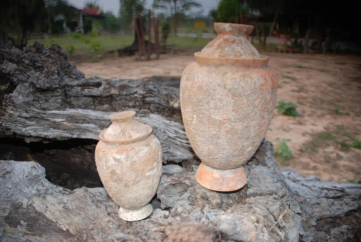
Open Days: Visits must be arranged in advance with Kut Du Subdistrict Administrative Organization and Ban Thin Subdistrict Administrative Organization
Opening Hours: No fixed public visitor schedule has been officially announced; travelers should confirm an appointment before departure
Ban Kut Kho Moei and Ban Kut Kwang Soi in Non Sang District, Nong Bua Lam Phu Province, are two closely related archaeological areas that reveal human settlement in the inland Northeast of Thailand from approximately 2,500 years ago. Major discoveries include human skeletons, earthenware vessels, bronze and stone bracelets, sandstone molds used for casting bronze axe heads, iron tools, and glass beads. Ban Kut Kho Moei is associated with the Non Phrao archaeological mound, while Ban Kut Kwang Soi is associated with Non Don Klang, also known as Non Pa Kluai. Both communities have local interpretation or museum spaces, but they do not operate like large ticketed museums with fixed daily schedules. Visitors should contact the responsible local authorities before traveling.
Ban Kut Kho Moei and Ban Kut Kwang Soi Archaeological Sites form one of the most informative archaeological landscapes in Nong Bua Lam Phu Province. Both are located in Non Sang District, where agricultural plains, seasonal waterways, low earthen mounds, the Phu Phan range, and the Phu Kao mountains create a landscape rich in natural resources. Their importance extends far beyond the discovery of old objects. The excavated evidence provides insight into settlement planning, farming, animal husbandry, pottery production, personal adornment, bronze casting, iron technology, long-distance exchange, funerary customs, and the ways in which communities understood life and death.
Ban Kut Kho Moei is situated in Moo 4 of Kut Du Subdistrict on the western side of the Phu Phan foothills. Its associated archaeological mound is known as Non Phrao. The mound measures approximately 150 meters in diameter and rises about 2 meters above the surrounding plain. Its recorded coordinates are 16.954380 latitude and 102.638756 longitude. The elevated land would have offered practical advantages for settlement, particularly during seasonal rains, while the surrounding lowland provided access to cultivable soil, water, forest products, stone, timber, and other resources from the nearby hills.
The Fine Arts Department surveyed Non Phrao in 1981 and conducted an excavation in 1993. Comparative study of its archaeological materials indicates a major occupation phase dating to approximately 2,500 years ago. Evidence associated with the Dvaravati period and the Lan Xang cultural sphere was also recorded. The Lan Xang material has been dated to approximately the 23rd–24th Buddhist centuries. These findings show that Non Phrao was not used during a single moment in time. Instead, the mound preserves evidence from different periods, reflecting repeated occupation, reuse, and changing cultural connections.
A community interpretation center, often described as the Non Phrao Archaeological Museum or Ban Kut Kho Moei Archaeological Information Center, communicates the history of the discoveries. Local government information records that excavated materials included human skeletons, bronze objects, bracelets, beads, vessels, axes, spearheads, and other artifacts. A number of original archaeological objects were transferred to archaeological and national museum authorities in Khon Kaen for professional conservation and secure storage. Travelers should therefore understand that Ban Kut Kho Moei is a source site and community learning center rather than a large museum displaying every original artifact recovered from the excavation.
Ban Kut Kwang Soi is located in Moo 2 of Ban Thin Subdistrict, near the eastern foothills of Phu Kao. Its archaeological mound is called Non Don Klang and is also known as Non Pa Kluai. The mound lies approximately 600 meters west of the present village. Official heritage records place it at 16.961466 latitude and 102.539838 longitude. It measures approximately 155 by 200 meters and rises about 2–3 meters above the surrounding plain, creating a clearly visible settlement mound within the agricultural landscape.
The history of archaeological work at Non Don Klang spans several decades. William Schöffler received permission from the Fine Arts Department to excavate the site in 1974. Further excavation was conducted by Fine Arts Unit 7 in Khon Kaen during 1992–1993, followed by additional survey work in 1997 by the regional archaeology and national museum office in cooperation with the Nong Bua Lam Phu provincial education authorities. This sequence of excavation, survey, recording, and comparison has made Non Don Klang an important reference point for studying prehistoric settlement in the Phu Kao area.
The principal occupation phase at Non Don Klang has also been dated to approximately 2,500 years ago. Archaeological records identify evidence from the prehistoric period as well as later Dvaravati and Lan Xang cultural phases. This chronological pattern closely resembles the sequence recorded at Non Phrao. The similarities explain why Ban Kut Kho Moei and Ban Kut Kwang Soi are frequently discussed together. They occupy the same broader landscape, are separated by a relatively short distance, and have produced comparable categories of artifacts.
The most visually powerful discoveries are the human skeletons. Their presence demonstrates that parts of the sites were used for burial as well as settlement activity. In archaeology, a skeleton is not treated simply as an isolated human remain. Its position, orientation, condition, associated vessels, ornaments, surrounding soil, and relationship to other burials can reveal information about age, health, diet, physical activity, social identity, and funerary customs. Visitors should therefore approach burial areas with respect and avoid treating them merely as unusual photographic subjects.
Earthenware pottery is another major category of evidence. Some vessels display shapes, manufacturing methods, or decorative characteristics comparable to pottery found in the Ban Chiang cultural tradition. Archaeologists use such similarities to compare chronology, technology, and cultural interaction across northeastern Thailand. However, the comparison does not mean that Ban Kut Kho Moei and Ban Kut Kwang Soi are part of the Ban Chiang World Heritage Site or that they were the same settlement. Each site has its own landscape, excavation history, stratigraphy, and local cultural sequence.
Pottery can reveal a wide range of everyday activities. Large vessels may have been used for storing water, grain, or other food products. Wide-mouthed containers were suitable for preparation and cooking, while smaller vessels could have held special substances or served ceremonial purposes. Traces of burning, food residue, tempering material, clay composition, and firing conditions help archaeologists reconstruct production and use. When a vessel is found inside a grave, its role may differ from that of a similar vessel found in a domestic area, demonstrating why archaeological context is essential.
Bronze bracelets demonstrate sophisticated knowledge of metallurgy. Producing bronze required access to raw materials, control of high temperatures, preparation of crucibles and molds, careful pouring of molten metal, and finishing after cooling. Bronze ornaments were therefore more than decorative possessions. They reflected technical specialization, skilled labor, access to materials, and the social meaning attached to personal appearance. When bracelets are found in graves, they can also provide evidence of identity, status, age, or the ceremonial treatment of the deceased.
Stone bracelets reveal a different but equally demanding craft tradition. Creating a balanced circular bracelet required the selection of suitable stone, repeated drilling, grinding, shaping, and polishing. Different stone types vary in hardness, color, texture, and source. Obtaining particular materials may have involved travel or exchange with other communities. Stone bracelets therefore provide information about craftsmanship, aesthetic preferences, resource procurement, and regional communication.
One of the most significant discoveries associated with the two sites is the sandstone mold used for casting bronze axe heads. A mold is direct evidence of production rather than simply a completed object. Its presence indicates that metal tools were manufactured locally or that craftspeople with casting knowledge worked within the community. The process required the preparation of metal, controlled heating, accurate alignment of mold sections, pouring, cooling, removal, and final sharpening. Such evidence shows that prehistoric communities in this part of Nong Bua Lam Phu possessed organized technological knowledge.
Iron tools reflect another major development in production and daily life. Iron could be fashioned into agricultural implements, woodworking tools, digging equipment, weapons, and cutting instruments. Stronger tools allowed communities to clear land, work timber, cultivate soil, and process materials more effectively. The coexistence of iron and bronze evidence shows that technological change did not occur as a sudden replacement of one material by another. Different metals continued to be selected according to function, availability, technical knowledge, and cultural value.
Glass beads are small objects with wide historical implications. Glass production requires specialized raw materials and technical control, while beads are lightweight, portable, and highly valued as personal ornaments. Their appearance in inland communities indicates participation in exchange networks extending beyond the immediate village. The people living near Phu Phan and Phu Kao were therefore connected to broader systems through which objects, materials, manufacturing knowledge, decorative styles, and social ideas circulated.
When skeletons, pottery, ornaments, casting molds, metal tools, and beads are considered together, they reveal economically diverse communities. The inhabitants cultivated crops, raised animals, stored and prepared food, produced ceramics, made ornaments, worked bronze and iron, and participated in exchange. Their settlements occupied strategic positions between lowland farmland and mountain resources. Access to water, forest products, stone, timber, cultivable soil, and communication routes played a direct role in the selection of these locations.
The presence of prehistoric, Dvaravati, and Lan Xang evidence also demonstrates long-term change. During the prehistoric period, communities did not leave written documents, so their history must be reconstructed from soil layers, artifacts, structures, and human remains. The Dvaravati era introduced changing religious, social, and regional connections across northeastern Thailand. Later Lan Xang influence linked communities more clearly with the cultural and religious world of the Mekong basin. The reuse of the same landscape over long periods confirms that these mounds retained practical and cultural importance for successive generations.
The statement that local pottery resembles Ban Chiang material should be understood as an archaeological comparison rather than a claim of identical identity. Ban Chiang in Udon Thani has its own extensive excavation sequence and international heritage status. Ban Kut Kho Moei and Ban Kut Kwang Soi have different environmental settings and local histories. Their importance lies in expanding the archaeological map of northeastern Thailand and demonstrating that technological and cultural traditions were shared across many interacting communities rather than concentrated at a single famous site.
The concentration of archaeological locations around Phu Kao and the Phu Phan range gives Non Sang District strong potential as a regional heritage route. Nearby rock-art and cave sites include Tham Mueam, Tham Achan Sim, Tham Suea Tok, and Tham Chan Dai. These places represent activities different from those documented on settlement and burial mounds. Viewed together, the sites show that the local landscape served as a place for habitation, ritual activity, movement, resource collection, and communication over a long period.
Community museums play an important role in maintaining the connection between archaeological evidence and the place where it was discovered. Although many original artifacts require professional conservation in national or regional museums, village interpretation spaces preserve local memory, discovery stories, and knowledge of the terrain. A meaningful visit should therefore extend beyond museum cases. Travelers should observe the height of the mounds, surrounding fields, waterways, road alignments, village locations, and the visual relationship between the settlements and nearby mountain ranges.
At Ban Kut Kho Moei, visitors should begin by contacting Kut Du Subdistrict Administrative Organization or the local community representative. Advance coordination confirms whether a person is available to open the learning space and provide information. A local guide can explain the relationship between the present village, the interpretation center, and the protected archaeological mound. This prevents visitors from entering the wrong area and provides access to knowledge that is not always available on signs or online descriptions.
Ban Kut Kho Moei also maintains a ritual connection with Non Phrao through an ancestral worship dance traditionally organized around the Songkran period. Villagers participate to honor the ancestors associated with the ancient mound and to promote awareness of the archaeological heritage. The event demonstrates that the relationship between the modern community and the ancient site is not limited to academic research. It also involves memory, respect for earlier inhabitants, and village identity. Visitors attending during the ceremony should dress appropriately and follow community instructions.
At Ban Kut Kwang Soi, travelers can study both the Non Don Klang mound and the community museum established in the village. The location of the mound approximately 600 meters from the settlement helps visitors understand the relationship between elevated ground, farmland, and the eastern foothills of Phu Kao. Walking through the area with a knowledgeable local person provides a clearer explanation of how ancient communities selected land that connected agricultural resources with the mountain environment.
Ban Thin Subdistrict Administrative Organization has continued to develop Non Don Klang as a local archaeological attraction. Recent public projects have included improvements to access roads and the installation of lighting infrastructure in the museum and archaeological tourism area. These projects confirm that the site remains part of the local tourism and educational landscape. Nevertheless, it does not function like a national museum or historical park with permanent ticket counters and staff on duty according to a fixed public schedule. Advance contact remains essential.
The combined visitor route can be understood through four principal areas: the Non Phrao archaeological mound, the Ban Kut Kho Moei community interpretation center, the Non Don Klang archaeological mound, and the Ban Kut Kwang Soi community museum. Each serves a different function. The mounds preserve the original archaeological context, the museum spaces communicate information, and the surrounding villages provide the social and environmental setting. A well-planned visit should include both indoor interpretation and outdoor observation.
The best time of day to visit is generally early morning or later afternoon, when outdoor temperatures are more comfortable. November through February provides cooler conditions for walking. During the hot season, visitors should carry drinking water, sun protection, and a hat. In the rainy season, local road and ground conditions should be confirmed in advance. Agricultural tracks and exposed soil around the mounds may become muddy or slippery, and visitors must avoid creating new paths across archaeologically sensitive ground.
Responsible behavior is essential at every archaeological location. Visitors must not dig, collect pottery fragments, remove stones, handle metal objects, or disturb human remains. Even a small fragment that appears unimportant may retain valuable information through its exact position in the soil. Removing it destroys its archaeological context and may violate Thai heritage protection law. Travelers should follow designated routes, avoid climbing into excavation areas, and request permission before photographing sensitive displays.
Photography should be undertaken with respect, especially around burials and human remains. Images should support education rather than sensationalism. Visitors should not pose disrespectfully beside skeletons, place personal belongings on excavation edges, or describe the sites using misleading supernatural claims. Accurate captions should distinguish Non Phrao from Non Don Klang and explain that the archaeological evidence represents several cultural periods rather than one single historical event.
The two sites are valuable field classrooms for families, schools, and university groups. Students can compare pottery forms, distinguish bronze from iron, examine the logic of casting molds, and discuss why archaeologists record the position of every object. Questions about settlement location, grave goods, technological specialization, and the movement of glass beads encourage deeper historical thinking than memorizing artifact names. Educational groups should coordinate in advance so the community can prepare an appropriate explanation.
Travelers with a strong interest in archaeology should visit both sites on the same day. Starting at Non Phrao in the morning provides an introduction to the settlement mound on the Phu Phan side of the district. Continuing to Non Don Klang later allows comparison of mound size, setting, museum interpretation, and the relationship with Phu Kao. Experiencing the two places together makes the idea of an ancient settlement network much easier to understand.
A half-day program is suitable for travelers staying in Non Sang who intend to study one site with a community guide. Approximately one to two hours should be allowed for the interpretation space and surrounding landscape. A full-day itinerary can combine Ban Kut Kho Moei, Ban Kut Kwang Soi, Wat Pa Phra That Ku, and selected natural or rock-art attractions. Cave and rock-art sites may require walking and local route knowledge, so they should not be entered independently without current access information.
Private transport is the most practical way to reach the sites. Neither location is served by a regular public transport route that stops directly at the museum areas. From Nong Bua Lam Phu town, travelers can follow Highway 2146 toward Non Sang for approximately 36 kilometers to the Ban Nong Waeng area, then continue on local roads toward Kut Du or Ban Thin Subdistrict. Older route descriptions mention approximately 5–7 kilometers from Ban Nong Waeng, but current coordinates and local directions should be used because road access has been improved and entrance routes may change.
Getting There for Ban Kut Kho Moei requires traveling toward Moo 4 of Kut Du Subdistrict and using the Non Phrao coordinates at 16.954380, 102.638756. Ban Kut Kwang Soi is reached through Moo 2 of Ban Thin Subdistrict, using the Non Don Klang coordinates at 16.961466, 102.539838. Before departure, contact Kut Du Subdistrict Administrative Organization at 042-315-805 for Ban Kut Kho Moei and Ban Thin Subdistrict Administrative Organization at 042-315-620 for Ban Kut Kwang Soi. Confirm the meeting point, available local contact, and road conditions.
Travelers without a private vehicle can use public transport to reach Non Sang town and then arrange a local vehicle. The driver, return time, total route, and price should be agreed upon before leaving town because vehicles do not operate to the archaeological sites according to a reliable timetable. Hiring a vehicle with a driver from Nong Bua Lam Phu town is a practical option for international travelers planning to cover both sites and nearby attractions in one day.
Community museum facilities are modest. Older travelers, wheelchair users, and families with young children should ask in advance about ground surfaces, steps, toilets, walking distance, and available assistance. The archaeological mounds are outdoor sites with uneven terrain. Closed, supportive footwear is preferable to sandals. Drinking water, medication, rain protection, and sun protection should be carried because services near the mounds are limited.
Meals can be planned in Kut Du, Non Sang town, or the Tat Hai community area. Restaurants in small communities may follow the owner's daily schedule and may close without an online announcement. Calling before departure is advisable. Non Sang offers local northeastern food, cooked-to-order dishes, noodles, shabu, grilled food, and cafés. Tat Hai is known for dishes connected with local fish and agricultural produce.
Accommodation options are distributed across Kut Du and Non Sang town. They consist mainly of small resorts, daily rooms, and locally operated hotels. Staying in Non Sang allows an early start for an archaeology-focused itinerary. Travelers covering several attractions across Nong Bua Lam Phu can also stay in the provincial town and make a day trip. Room condition, parking, check-in arrangements, and cancellation rules should be confirmed directly with each property.
The significance of Ban Kut Kho Moei and Ban Kut Kwang Soi lies in their ability to extend the history of Nong Bua Lam Phu far beyond the modern establishment of the province. Evidence dating to approximately 2,500 years ago demonstrates communities with knowledge of agriculture, craft production, metallurgy, personal ornamentation, and exchange. The later Dvaravati and Lan Xang layers show that the same landscape continued to participate in changing cultural networks over many centuries.
Protecting these sites is not the responsibility of government archaeologists alone. Local residents discovered, safeguarded, interpreted, and transmitted knowledge of the areas. Visitors contribute to conservation by respecting boundaries, leaving every object in place, avoiding litter, using community services, and sharing accurate information. Responsible tourism gives local museums a reason to remain active and supports continued protection of the archaeological landscape.
Ban Kut Kho Moei and Ban Kut Kwang Soi are therefore best suited to travelers who wish to understand northeastern Thailand through the lives of earlier communities rather than through a conventional sightseeing stop. Together, they present a story of settlement on raised mounds, pottery making, bronze casting, iron use, personal adornment, regional exchange, and care for the dead. Advance coordination and respectful behavior transform a visit into a meaningful encounter with one of Nong Bua Lam Phu's most important archaeological landscapes.
| Name | Ban Kut Kho Moei Archaeological Site, or Non Phrao, and Ban Kut Kwang Soi Archaeological Site, or Non Don Klang |
| Location | Non Sang District, Nong Bua Lam Phu Province, Northeastern Thailand |
| Ban Kut Kho Moei Address | Non Phrao, Ban Kut Kho Moei, Moo 4, Kut Du Subdistrict, Non Sang District, Nong Bua Lam Phu 39140 |
| Ban Kut Kwang Soi Address | Non Don Klang, Ban Kut Kwang Soi, Moo 2, Ban Thin Subdistrict, Non Sang District, Nong Bua Lam Phu 39140 |
| Ban Kut Kho Moei Coordinates | 16.954380, 102.638756 |
| Ban Kut Kwang Soi Coordinates | 16.961466, 102.539838 |
| Highlights | Settlement and burial mounds dating to approximately 2,500 years ago, with human skeletons, pottery, bronze and stone ornaments, bronze-casting molds, iron tools, and glass beads |
| Ban Kut Kho Moei Research History | Non Phrao was surveyed by the Fine Arts Department in 1981 and excavated in 1993 |
| Ban Kut Kwang Soi Excavation History | First excavated in 1974, with further excavation in 1992–1993 and additional survey in 1997 |
| Periods and Dating | A principal phase dating to approximately 2,500 years ago, with evidence continuing through the prehistoric, Dvaravati, and Lan Xang periods; Lan Xang evidence dates to approximately the 23rd–24th Buddhist centuries |
| Non Phrao Mound | Approximately 150 meters in diameter and about 2 meters above the surrounding plain |
| Non Don Klang Mound | Approximately 155 × 200 meters and about 2–3 meters above the surrounding plain, located around 600 meters from the present village |
| Key Evidence | Human skeletons, earthenware vessels with features comparable to Ban Chiang material, bronze bracelets, stone bracelets, sandstone molds for bronze axe heads, iron tools, and glass beads |
| Main Areas / Zones | 1. Non Phrao Archaeological Mound at Ban Kut Kho Moei 2. Ban Kut Kho Moei Archaeological Information or Community Museum Area 3. Non Don Klang Archaeological Mound at Ban Kut Kwang Soi 4. Ban Kut Kwang Soi Community Museum |
| Artifact Conservation | Some original artifacts are conserved by archaeological and national museum authorities in Khon Kaen |
| Related Tradition | Ban Kut Kho Moei holds an ancestral worship dance around Songkran to honor the ancestors associated with Non Phrao and promote community awareness of the archaeological heritage |
| Ban Kut Kho Moei Caretaker | Kut Du Subdistrict Administrative Organization and Ban Kut Kho Moei community |
| Ban Kut Kwang Soi Caretaker | Ban Thin Subdistrict Administrative Organization and Ban Kut Kwang Soi community |
| Current Status | Both remain listed in government archaeological and tourism databases. Access roads and lighting infrastructure at Non Don Klang were developed during 2024–2025. Visits should be arranged in advance |
| Open Days | By prior appointment with local authorities or community representatives |
| Opening Hours | No fixed public visitor timetable has been announced; confirm a visiting time before departure |
| Visitor Arrangement | The sites do not operate through a standard museum ticketing system. Contact the caretakers to arrange access to interpretation areas and receive current guidance |
| Facilities | Community museum or interpretation buildings, local road access, and recently developed lighting infrastructure at Non Don Klang |
| Visitor Conduct | Do not dig, collect, move, or touch artifacts and human remains. Follow designated paths and ask permission before photographing burial areas or indoor displays |
| Travel Information | From Nong Bua Lam Phu town, follow Highway 2146 toward Non Sang for approximately 36 km to the Ban Nong Waeng area, then continue on local roads toward Kut Du or Ban Thin. Use the coordinates and local guidance for the final approach |
| Ban Kut Kho Moei Contact | Kut Du Subdistrict Administrative Organization, Tel. 042-315-805 |
| Ban Kut Kwang Soi Contact | Ban Thin Subdistrict Administrative Organization, Tel. 042-315-620 |
| Official Information Channels | Kut Du Subdistrict Administrative Organization website and Ban Thin Subdistrict Administrative Organization website |
| Nearby Tourist Attractions | Approximate driving distances from Ban Kut Kho Moei / Ban Kut Kwang Soi respectively 1. Ban Kut Kwang Soi or Ban Kut Kho Moei Archaeological Site, 13 km / 13 km 2. Wat Pa Phra That Ku, 6 km / 10 km 3. Tham Mueam Archaeological and Rock-Art Site, 20 km / 7 km 4. Tham Achan Sim Archaeological and Rock-Art Site, 19 km / 6 km 5. Phu Kao–Phu Phan Kham National Park, 27 km / 18 km 6. Tat Hai Tourism Community and Huai Bong Reservoir, 35 km / 25 km |
| Nearby Restaurants | Approximate driving distances from Ban Kut Kho Moei / Ban Kut Kwang Soi respectively 1. Ran Lang Amphoe Non Sang, 16 km / 13 km, Tel. 087-226-9021 2. Kuai Tiao Kai Mara Ong Lom Yak, Non Sang Branch, 15 km / 12 km, Tel. 092-197-1287 3. Chill Shabu Non Sang, 16 km / 13 km, Tel. 062-454-3023 4. Noot's Cafe Non Sang, 18 km / 15 km, Tel. 092-824-1662 5. Yai Pae Miang Pla Phao Tat Hai, 35 km / 25 km, Tel. 061-308-3396 |
| Nearby Accommodations | Approximate driving distances from Ban Kut Kho Moei / Ban Kut Kwang Soi respectively 1. Ma Non Na Resort, Kut Du, 4 km / 14 km, Tel. 061-641-5596 2. Chom Duen Phu Kao Resort, 14 km / 10 km, Tel. 092-951-4524, 089-532-2266 3. Oranee Resort Non Sang, 17 km / 14 km, Tel. 081-118-2500 4. Muji House Resort Non Sang, 16 km / 13 km, Tel. 083-218-2749, 095-668-1813 5. Palm Resort Non Sang, 16 km / 13 km, Tel. 095-273-4675 |
Frequently Asked Questions (FAQ)
Q: Are Ban Kut Kho Moei and Ban Kut Kwang Soi the same archaeological site?
A: No. They are separate but closely related sites. Ban Kut Kho Moei is associated with Non Phrao in Kut Du Subdistrict, while Ban Kut Kwang Soi is associated with Non Don Klang in Ban Thin Subdistrict. Both are located in Non Sang District and have produced comparable categories of archaeological evidence.
Q: How old are the two archaeological sites?
A: Their principal archaeological phases date to approximately 2,500 years ago. Evidence from later Dvaravati and Lan Xang cultural periods has also been recorded, with the Lan Xang material dating to approximately the 23rd–24th Buddhist centuries.
Q: What artifacts were discovered at Ban Kut Kho Moei and Ban Kut Kwang Soi?
A: Discoveries include human skeletons, earthenware vessels, bronze bracelets, stone bracelets, sandstone molds for casting bronze axe heads, iron tools, glass beads, and other objects connected with settlement and burial activities.
Q: Is the pottery identical to pottery from Ban Chiang?
A: Some vessels share forms, production techniques, or decorative characteristics with material associated with the Ban Chiang cultural tradition. The comparison is useful for archaeological study, but the Nong Bua Lam Phu sites have their own local contexts and are not part of the Ban Chiang World Heritage Site.
Q: Are the sites open every day?
A: No fixed public schedule has been officially announced. Access to community interpretation buildings and important archaeological areas should be arranged with the local administrative organizations or community representatives before traveling.
Q: Is there an admission fee?
A: The sites do not operate through a standard ticketing system like a large national museum. Travelers should ask the caretakers directly about current visitor arrangements, community activities, or any local guiding expenses.
Q: Can both sites be visited in one day?
A: Yes. They are located within Non Sang District and are approximately 13 km apart by local road. Arrange appointments with both communities and begin the trip in the morning.
Q: Can visitors take pottery fragments or objects found on the ground?
A: No. Digging, collecting, moving, or removing any object is prohibited. The exact position of every fragment is part of the archaeological record, and archaeological materials are protected under Thai law.
 Category: ●Art, Culture and Heritage
 Group: ●Historical Sites and Monuments
Last Update : 3 MonthAgo
 Last Update : 3 MonthAgo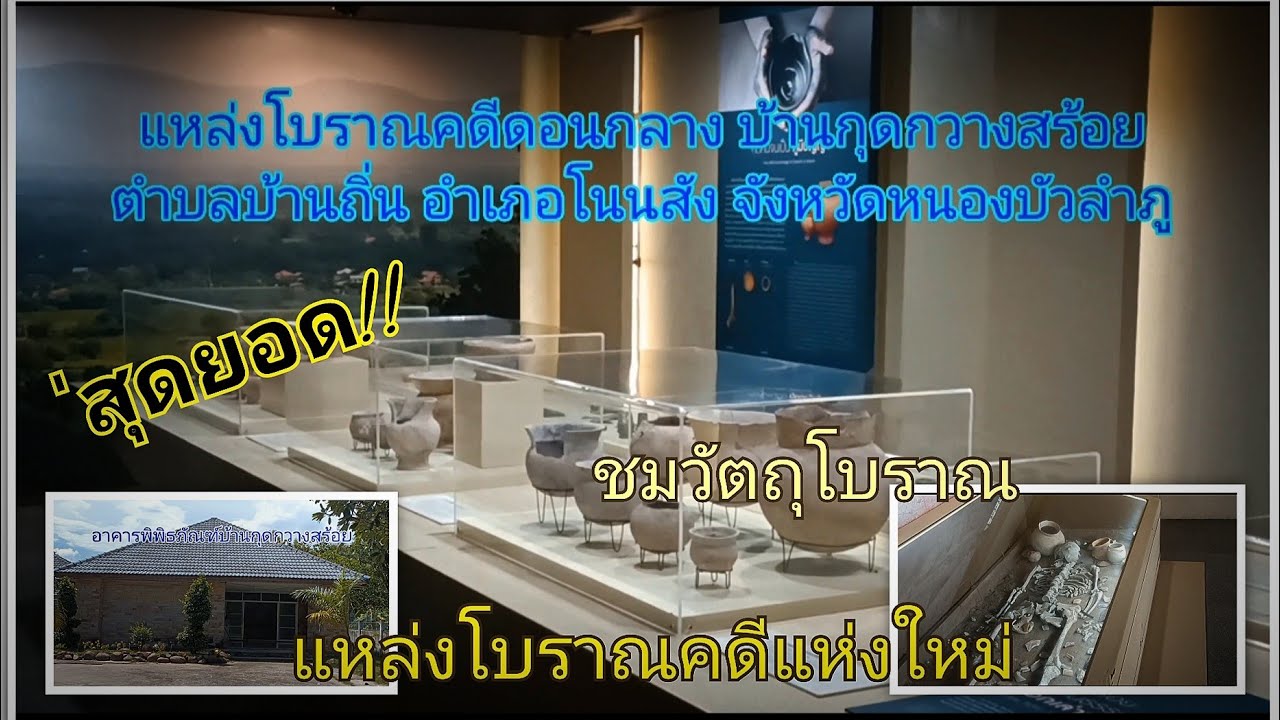
 Click to Access the Navigation Map GPS
Ban Kut Ko Moei and Ban Kut Kwang Soi Map
 Historical Sites and Monuments(4)
 Landmarks and Memorials(1)
 Art, Craft Centres, Tradition(1)
 Museums(3)
 Places of Worship
 Temple(10)
 Other Sacred Sites(6)
 Suburban Living
 Village, Community(3)
 Nature and Wildlife
 National Parks and Marine Reserves(3)
 Mountain (Doi)(5)
 Dam, Reservoir, Lake(5)
 Waterfalls(1)
 Caves(6)
 River, Canal(2)
 Bays and Beaches(1)
 Other natural attractions(3)
 Travel Articles, Recipes
 Travel Review, Food Review(1)


