
lovethailand home >Northeastern Travel Attractions >Bueng Kan Travel Attractions >Seka >Ban Tong > Tat Chanaen Waterfall
TL;DR: Tat Chanaen Waterfall. Highlights include Khua Hin natural stone bridge, sandstone channels, broad rock platforms, forest streams, and the natural environment of Phu Wua.

Tat Chanaen Waterfall
Visitor Access: Tat Chanaen Waterfall is located within Phu Wua Wildlife Sanctuary. Entry is subject to official permission, seasonal restrictions, and ranger instructions.
Visiting Hours: Daytime visits are possible only when the relevant trails are officially open. The waterfall is most prominent during the rainy season.
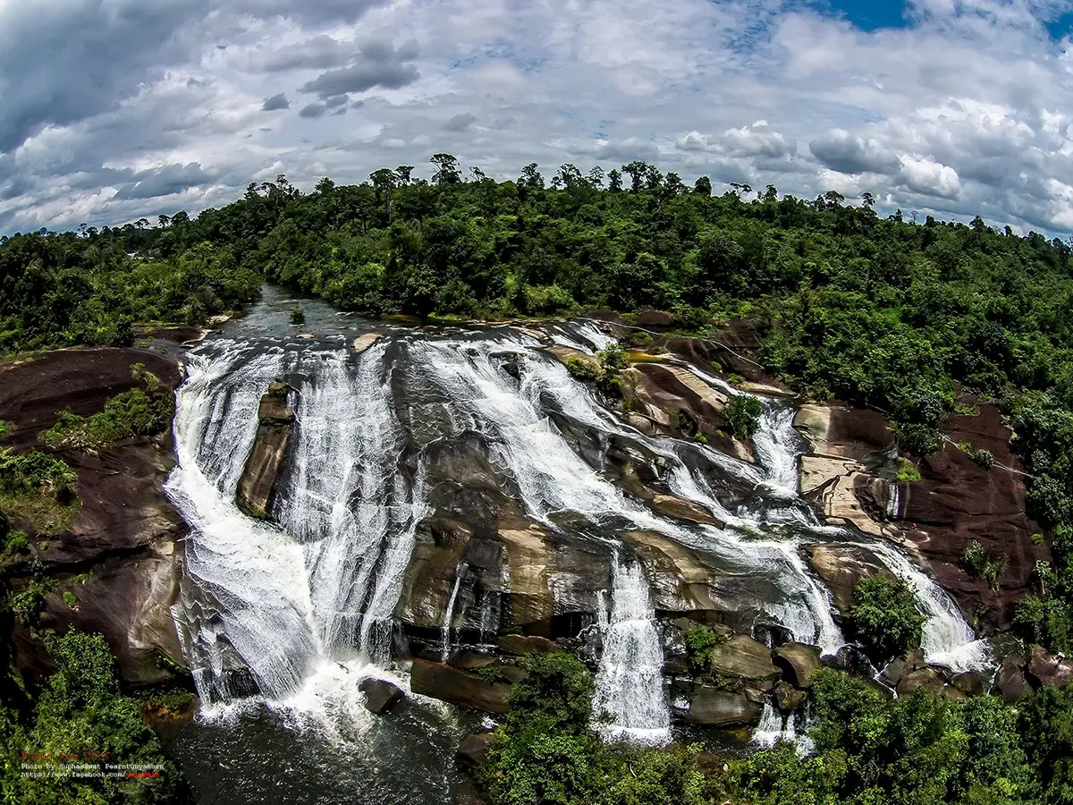
Tat Chanaen Waterfall in Bueng Kan Province, also known by its former name Tat Sanaen Waterfall, is a large natural waterfall within Phu Wua Wildlife Sanctuary in northeastern Thailand. It is distinguished by streams flowing across a sandstone landscape and descending through two principal waterfall levels approximately 300 metres apart. One of the area's most remarkable features is Khua Hin, a natural stone bridge formed where water passes beneath an enormous rock formation. Together with extensive sandstone terraces, forest streams, and diverse natural habitats, these features make the waterfall an important destination for understanding the geology and ecology of the Phu Wua forest landscape.
Tat Chanaen forms part of a network of streams flowing across the Phu Wua sandstone range. Rainwater collected in the upper forest drains into natural channels and rock fissures before descending over changes in elevation. Rather than falling from one narrow vertical cliff, the water spreads across broad rock surfaces and follows several channels, creating a landscape shaped by flowing water and exposed sandstone. The waterfall's distinctive appearance comes from the relationship between the contours of the rock, the movement of the water, and the surrounding vegetation.
Phu Wua is one of the most important natural areas in Bueng Kan Province. Its protected forest landscape extends across areas associated with Bung Khla, Seka, and Bueng Khong Long districts. The terrain includes sandstone ridges, extensive rock platforms, deciduous dipterocarp forest, dry evergreen forest, and wetter evergreen vegetation in selected locations. These different environments support wildlife, provide important watershed functions, and create opportunities for studying the natural systems of northeastern Thailand.
Tat Chanaen Waterfall is associated with several communities around the approaches to Phu Wua. Many tourism descriptions identify Ban Phu Ngoen in Ban Tong Subdistrict, Seka District, as a principal reference point for the tourist access route. Nong Doen Subdistrict Administrative Organization, meanwhile, identifies the waterfall with Ban Thep Mi Chai in Nong Doen Subdistrict, Bung Khla District, and places it under the responsibility of the Chanaen Forest Protection Unit. These references reflect the broad geography of the Phu Wua forest and its approaches from different communities. Visitors commonly follow the routes through Ban Chaiyaphon and Ban Phu Ngoen toward the ranger-controlled area.
The waterfall's name is rooted in northeastern Thai terminology. Its earlier name, Tat Sanaen, includes the word tat, used locally for flowing water over rocky ground or a waterfall. The second part of the name has been explained in different ways in local accounts and tourism descriptions, often in connection with the waterfall's exceptional beauty. Today, Tat Chanaen is the name most commonly used in tourism listings and references to the attraction.
A defining feature of Tat Chanaen is the movement of water across extensive sandstone surfaces. Some channels follow sloping rock, others run through narrow fissures, and several flows join as they reach lower ground. This produces a waterfall whose appearance changes substantially according to rainfall. During the wet season, the flow spreads more widely, while lower water conditions reveal the underlying channels, terraces, and geological formations more clearly.
When rainfall is abundant, water travels vigorously across the rock, producing a continuous sound and refreshing spray. At lower levels, visitors can observe the shape of the sandstone and the grooves through which the streams normally flow. Seasonal change is therefore a central part of the attraction. The waterfall offers different views of the same natural system, illustrating how rainfall and terrain together determine the appearance of a sandstone cascade.
Tat Chanaen has two principal waterfall levels separated by approximately 300 metres. The area between them consists of natural stream channels, rocky ground, and forest sections. Moving between the levels involves more than simply walking to another viewpoint. The terrain reveals a sequence of sandstone surfaces, flowing water, streamside vegetation, and naturally formed pools, providing a close view of the way water shapes the landscape.
The first waterfall level is notable for the water passing over uneven sandstone and the surrounding rock terraces. During periods of higher flow, the water can spread across a wider area, creating a strong visual effect. At lower flow, grooves and irregularities in the rock become more obvious. These features illustrate the erosive action of water and the influence of natural fractures in the sandstone.
The second waterfall level is associated with additional stream channels and natural pools. The route between the levels includes uneven rock and areas where water passes through the landscape. Descriptions of the wider walking route also refer to a place called Bueng Chorakhe Waterfall, where a lower cascade enters a pool. This feature adds variety to the experience and demonstrates how one drainage system can form several different types of small and large waterfalls.
Besides the two main waterfall levels, Khua Hin, or the natural stone bridge, is a major landmark. The formation consists of an extensive rock surface with an opening beneath it through which water flows. It is described as approximately 100 metres long and is one of the best-known natural features associated with Tat Chanaen. Its unusual structure distinguishes the area from waterfalls where the water remains entirely exposed on the rock surface.
Khua Hin is closely related to the structure of the sandstone and the long-term development of natural drainage channels. Water passing through fractures and weaker sections of rock gradually reshapes portions of the terrain, sometimes creating openings beneath larger rock masses. The sight of water disappearing under the stone and emerging farther along its course provides a particularly striking example of natural landscape formation.
During the rainy season, Khua Hin can become even more dramatic as additional water reaches the stream. Faster currents pass through the rocky channels and create powerful sounds and spray. This same increase in flow makes the area potentially hazardous. Slippery rock, concealed openings, and rapidly moving water require particular caution, especially when conditions are affected by heavy rainfall in the upper watershed.
The natural bridge has value beyond its visual appeal. Together with the waterfall levels, it demonstrates how a single stream can produce several contrasting landforms: broad rock terraces, narrow channels, pools, falling water, and underground passages beneath exposed stone. The area therefore offers an accessible example of the relationship between sandstone geology and running water, within the limits of officially permitted access.
Access to Tat Chanaen differs from travel to a waterfall located immediately beside a paved public road. The approach involves local roads and forest-edge routes, followed by access controlled by the wildlife sanctuary. Tourism route descriptions identify a section of approximately 13 kilometres between the Ban Chaiyaphon and Ban Phu Ngoen areas, followed by another approach road of approximately 5 kilometres toward the waterfall. Older descriptions identify the final section as narrow and rough, making road conditions and vehicle suitability important considerations.
Reaching the waterfall itself involves walking from the Chanaen Forest Protection Unit area through natural terrain associated with Khua Hin. Historical travel accounts describe sections of open forest, small crossings over rock channels, and streamside footpaths. The actual route available to visitors depends on the sanctuary's current permissions, weather conditions, water levels, and wildlife protection requirements. The existence of a historical walking route does not mean that it is always open for independent exploration.
The surrounding forest is essential to the existence of Tat Chanaen Waterfall. Forest vegetation intercepts rainfall, influences runoff, helps retain soil moisture, and supports the streams feeding the waterfall. Tree cover also creates habitats for many forms of life. The waterfall is therefore one visible part of a larger ecological network whose condition depends on the health of the surrounding watershed.
Phu Wua contains a combination of relatively open woodland and denser forest areas. Differences in elevation, soil depth, drainage, and moisture create different conditions for plant growth. Stream corridors tend to remain more humid than exposed rock platforms. As travelers move through the landscape, they may encounter considerable changes in vegetation over relatively short distances, illustrating the ecological variety of the protected area.
The sandstone platforms support plants adapted to shallow soils and seasonal moisture. During the rainy season, small plants can become established in cracks and depressions where water collects. Areas that appear comparatively dry during the hot season may develop patches of green vegetation and seasonal flowers after sustained rainfall. This is one of the distinctive characteristics of the rock-platform environments found in parts of northeastern Thailand.
One plant associated with the natural identity of Bueng Kan is Sirindhornia, commonly referred to locally as Sirinthonwanli or Sam Sip Song Pradong. Tourism descriptions of the Tat Chanaen route mention its orange-brown flowering clusters, especially during the August-to-October period. The plant is among the natural features that contribute to the botanical interest of the Phu Wua forest.
Plants along the waterfall trails are more than decorative features. They provide food sources, shelter, and breeding habitats for insects and other small animals. Vegetation growing around stream channels also contributes to local soil stability and the formation of specialized habitats. Observing these relationships offers an additional dimension to the area's natural history beyond its waterfalls and rock formations.
Phu Wua Wildlife Sanctuary is important for the protection of several wildlife species. Animals associated with the forest include wild elephants, barking deer, bears, civets, junglefowl, and other forest fauna. Wildlife conservation is the sanctuary's primary purpose, and human access must be managed in a way that protects animals and their habitats. Visitors must remain within authorized areas and should never approach or attempt to feed wildlife.
Wild elephants are particularly important to the sanctuary's management. They can move through forest paths and areas adjoining local communities, making their presence relevant to visitor safety. Restrictions on access are therefore not solely related to the condition of the walking trails. They may also reflect the need to reduce encounters between people and wildlife and to preserve natural movement corridors.
Tat Chanaen is also linked with the wider Phu Wua trekking landscape, particularly routes involving Lan America and sandstone platforms on higher ground. Such routes cross different forest and geological environments, offering views of rock terraces, seasonal vegetation, pools, and surrounding landscapes. Longer-distance trekking and overnight stays within the protected area require adherence to the relevant regulations and permissions.
Lan America is a name associated with a broad rock-platform area on Phu Wua and appears in accounts of the region's trekking routes. Its landscape includes exposed sandstone, seasonally flowering plants, and elevated views over forested terrain. Reaching these areas is a forest-trekking activity rather than a short roadside excursion. The route illustrates the transition from higher sandstone surfaces to the drainage systems and waterfalls below.
Sandstone is the principal geological element shaping many of Phu Wua's distinctive natural attractions. Fractures, changes in elevation, and differences in resistance to erosion influence the development of channels and pools. As water passes across these features, it produces waterfalls with different forms. Tat Chanaen, Khua Hin, and other waterfalls within the sanctuary provide contrasting examples of these geological processes.
The appearance of the stone itself changes with moisture and light. Sandstone surfaces can appear paler when dry and darker after rain. Sections covered in algae or small plants may be especially slippery. A rock surface that appears firm and accessible can therefore present significant hazards, particularly on sloping ground or near flowing water. The condition of the surface matters as much as its shape.
During the wet season, rain falling throughout the upper watershed increases the amount of water entering the streams. The waterfall often becomes more impressive as a result, but higher flow also creates a risk of flash flooding. Water levels can rise even when it is not raining at the waterfall itself, because large quantities of water may arrive from distant upstream areas. The volume and appearance of the stream are consequently important safety factors.
The rainy season is the period most closely associated with the waterfall's dramatic flowing-water scenery and lush vegetation. Nevertheless, high water does not mean that every rainy day is suitable for a visit. The sanctuary's assessment of actual conditions determines whether access is permitted. Seasonal beauty and visitor safety must be considered together in any visit to Tat Chanaen.
After the rainy season, water levels may gradually decline. More of the sandstone platforms and rock channels become visible, creating opportunities to appreciate the structure of the landscape. The resulting scenery differs from the powerful cascades of the wet season. During the dry season, the waterfall may have very little water because its flow is strongly dependent on rainfall.
The natural environment offers several areas of interest, including the waterfall's drainage system, the unusual stone bridge, sandstone terraces, and plant communities growing beside streams. These features make Tat Chanaen valuable for environmental education. A visit can provide a more complete understanding of the local ecosystem than simply viewing the waterfall from one point.
For nature photographers, the area contains moving water, broad sandstone surfaces, green vegetation, rock fissures, and the distinctive structure of Khua Hin. Changing sunlight can alter reflections on the water and bring out details of wet rock and foliage. Photography must remain within designated or permitted areas; exposed edges and fast-flowing channels are not suitable places to enter for a better image.
Visitors interested in botany and ecology may find the route particularly rewarding because its vegetation changes with moisture and topography. Humid streamside sections contrast with more exposed sandstone areas. Small changes in ground conditions can support different plant groups, contributing to the diversity of the sanctuary's habitats.
Tat Chanaen also contributes to the identity of communities around Phu Wua. The waterfall and the approaches through Ban Phu Ngoen, Ban Chaiyaphon, and Nong Doen are part of the local understanding of the landscape. The relationship between surrounding communities and the forest extends beyond tourism, encompassing water resources, environmental conditions, and the challenges of living beside protected wildlife habitat.
Settlements along the approach roads provide a transition between the provincial road network and the protected forest. Travelers pass through agricultural areas and local communities before reaching the more natural terrain of Phu Wua. This changing landscape reveals something of the region's settlement patterns and the close proximity between farming communities and conservation land.
Well-managed nature tourism can support local services, including restaurants, accommodation, and transport providers. However, the sanctuary's conservation purpose places limits on how tourism can develop. Managing visitor numbers, restricting access where necessary, and maintaining quiet wildlife habitats are important to achieving a sustainable balance between public enjoyment and environmental protection.
The Chanaen Forest Protection Unit is the principal local unit associated with management of the waterfall area. Its responsibilities form part of the broader forest and wildlife protection system of Phu Wua Wildlife Sanctuary. Ranger supervision is important for controlling access and responding to changing conditions, including heavy rain, hazardous trails, and wildlife activity.
Unlike a commercial attraction, a wildlife sanctuary exists primarily to conserve animals and their natural habitats. Visitor access may be limited to designated areas and certain periods. Some routes may require permission, while others may be closed to reduce risks or protect wildlife. All visitors must comply with the sanctuary's current rules and instructions rather than assuming that a published historical route remains open.
Conservation rules include avoiding litter, not damaging plants or natural rock surfaces, refraining from disturbing wildlife, and staying out of restricted zones. Food waste is particularly problematic in wildlife habitats because it can alter animal behaviour and attract animals toward people. Responsible use of the area contributes to the long-term protection of its ecological values.
Visiting Tat Chanaen requires more physical preparation than stopping at a waterfall beside a paved road. Uneven rock, slippery surfaces, and sections affected by running water can make walking demanding. Footwear with reliable traction, clothing suited to forest conditions, and protection against rain are appropriate for permitted outdoor activities. Route length and difficulty should always be assessed according to the actual trail conditions and ranger guidance.
Flash flooding is one of the greatest dangers during heavy rainfall. Sandstone channels can carry runoff quickly, and a shallow stream may become deeper and stronger over a relatively short period. Standing on isolated rocks in a stream or attempting to cross rising water presents serious risks. Visitors should never treat the water as safe merely because it appeared calm earlier in the day.
Floodwater may originate in parts of the watershed that cannot be seen from the waterfall. Changes in water colour, volume, and flow can therefore be important warning signs. Rangers are responsible for monitoring conditions and deciding when particular routes can be used. Their instructions are essential to safe access.
Tat Chanaen is not suitable for hurried, unaccompanied exploration of unfamiliar trails. The drainage system contains fissures, pools, and paths that can change character between seasons. Appreciating the landscape within permitted limits is more important than attempting to reach every feature shown on a map or described in older travel accounts.
Khua Hin deserves particular attention in safety planning. Although it resembles a bridge, it is a naturally formed rock structure rather than an engineered pedestrian crossing. Water channels beneath the stone and changing current conditions can create concealed hazards. Approaching the edges or openings should be avoided wherever access is restricted.
Several other waterfalls within Phu Wua provide useful comparisons with Tat Chanaen. Chet Si Waterfall is known for water flowing over sandstone and producing spray that may reveal changing colours in sunlight. Its forest landscape and broad rock features connect it geologically with Tat Chanaen, although the two attractions have different approaches and visitor access arrangements.
Tham Phra Waterfall is another major attraction in Bueng Kan. It has a broad sandstone waterfall landscape and an access route associated with a boat landing and onward travel toward the waterfall. Its character differs from that of Tat Chanaen, which is particularly known for the natural stone bridge and its trekking environment.
Tham Fun Waterfall is another protected natural site in Phu Wua. Streams flow across sandstone surfaces and through channels that create small natural pools. Comparing Tham Fun with Tat Chanaen reveals the variety of waterfalls produced within the same geological region. Their physical forms and access requirements are nevertheless different.
Tat Nok Khian Waterfall is also associated with Phu Wua and appears in provincial tourism and protected-area announcements. It shares the wider forest and sandstone setting of the other waterfalls. Visitor access to these places depends on official conditions, so the opening hours or permissions for one site should not be assumed to apply to another.
A journey through Phu Wua therefore requires attention to the individual characteristics of each destination. Some waterfalls have relatively short approaches, while others involve more demanding forest routes. The distance between sites on a map does not fully indicate the effort needed to reach them, because road conditions, walking terrain, and conservation restrictions can be decisive.
Phu Thok, home to Wat Jetiyakhiri Wihan in Si Wilai District, is another famous attraction in Bueng Kan. The temple is known for wooden walkways built along the sandstone cliffs and for its association with Buddhist practice. Although it offers a very different experience from Tat Chanaen, both places illustrate the importance of sandstone landforms to the province's distinctive landscape.
Hin Sam Wan, or Three Whale Rock, within the Phu Sing area is another striking example of sandstone shaping Bueng Kan's natural attractions. Its three enormous rock formations resemble whales resting above a forest landscape. When considered alongside Khua Hin, the site illustrates how different geological processes can produce a remarkable variety of landforms within the same province.
Bueng Kan offers a broad range of natural environments, from major river landscapes and wetlands to forested hills and elevated sandstone platforms. Visitors interested in ecology can compare the region's different habitats through its protected forests, wetlands, and Mekong River environments. Tat Chanaen occupies an important place within this wider natural geography.
For travelers who want to understand the area in depth, Tat Chanaen is best appreciated not simply as falling water but as the outcome of a complex landscape. Its broad sandstone surfaces, rock passages, two waterfall levels, and streamside vegetation all contribute to the character of Phu Wua. The attraction demonstrates the close relationship between geological structure, rainfall, forest cover, and natural water flow.
The site also shows that natural landscapes remain in constant change. Although the waterfall occupies the same geographical area, its flow, vegetation, surface moisture, and visible stone features vary throughout the year. This changing character is part of what distinguishes a natural attraction from a built environment whose features can be controlled more directly.
Protecting Tat Chanaen requires attention to the surrounding watershed as well as the waterfall itself. Damage to forest vegetation, soil, or drainage patterns may affect conditions farther downstream. Conservation of the broader landscape is therefore central to maintaining the attraction's ecological value for future generations.
Getting There Access to Tat Chanaen Waterfall begins with travel through Bueng Kan Province using Highway 212 and connecting local roads toward Ban Chaiyaphon and Ban Phu Ngoen. Tourism route descriptions identify approximately 13 kilometres along the Ban Chaiyaphon–Ban Phu Ngoen approach, followed by a further road section of approximately 5 kilometres toward Tat Chanaen. The final approach requires attention to road conditions, particularly after rainfall. Access to Khua Hin and the waterfall itself follows routes associated with the Chanaen Forest Protection Unit and is subject to the permission of Phu Wua Wildlife Sanctuary.
Visitors seeking access information should contact Phu Wua Wildlife Sanctuary, the authority responsible for the protected area. The sanctuary determines which nature study routes may be used and under what conditions. During heavy rain or periods when access restrictions apply, ordinary tourism schedules cannot override official safety and conservation decisions.
Tat Chanaen Waterfall is one of Bueng Kan's distinctive natural attractions, combining a two-level sandstone waterfall, the remarkable Khua Hin natural stone bridge, forest streams, and the biodiversity of Phu Wua. Its significance lies not only in its scenery but also in its value for environmental education and watershed conservation. A visit offers insight into the interconnected relationship between forests, running water, sandstone formations, wildlife, and the communities surrounding this important protected landscape.
| Place Name | Tat Chanaen Waterfall |
| Former Name | Tat Sanaen Waterfall |
| Location And Access Area | Phu Wua Wildlife Sanctuary, Bueng Kan Province. Tourist access is associated with Ban Chaiyaphon and Ban Phu Ngoen, Ban Tong Subdistrict, Seka District. Nong Doen Subdistrict Administrative Organization identifies the waterfall area with Ban Thep Mi Chai, Nong Doen Subdistrict, Bung Khla District. |
| Managing Authority | Phu Wua Wildlife Sanctuary and the Chanaen Forest Protection Unit, Department of National Parks, Wildlife and Plant Conservation |
| Contact Numbers | Phu Wua Wildlife Sanctuary: +66 89 862 3389 or +66 42 429 362 |
| Waterfall Characteristics | A natural sandstone waterfall with two principal levels approximately 300 metres apart |
| Highlights | Khua Hin natural stone bridge, sandstone channels, broad rock platforms, forest streams, and the natural environment of Phu Wua |
| Main Areas And Natural Features | 1. Chanaen Forest Protection Unit 2. Khua Hin Natural Stone Bridge 3. First Waterfall Level 4. Second Waterfall Level 5. Stream Channels And Natural Pools 6. Bueng Chorakhe Waterfall along the nature route |
| Khua Hin | A natural rock bridge approximately 100 metres long, with water flowing beneath an extensive stone formation |
| Waterfall Season | Rainy season; water levels depend on rainfall in the upper watershed |
| Open Days | Visitor access is permitted only during periods designated by Phu Wua Wildlife Sanctuary |
| Visiting Hours | Subject to the hours authorized by rangers for the Tat Chanaen route |
| Access Requirements | Visitors must comply with official opening announcements, forest protection rules, and safety restrictions |
| Getting There | Follow the Ban Chaiyaphon–Ban Phu Ngoen route for approximately 13 km, then the approach toward Tat Chanaen for approximately another 5 km, followed by the permitted nature trail |
| Activities | Viewing sandstone formations, studying the natural environment, observing Khua Hin, exploring seasonal plant life, and hiking on authorized routes |
| Notable Plants | Sirinthonwanli, also locally known as Sam Sip Song Pradong, associated with the natural environment of Phu Wua |
| Safety Considerations | Flash floods, slippery sandstone, strong currents, concealed rock passages, wildlife, and seasonally changing trails |
| Related Natural Attractions | 1. Khua Hin Natural Stone Bridge, along the Tat Chanaen route 2. Bueng Chorakhe Waterfall, within the Tat Chanaen drainage route 3. Chet Si Waterfall, Phu Wua Wildlife Sanctuary 4. Tham Phra Waterfall, Phu Wua Wildlife Sanctuary 5. Tham Fun Waterfall, Phu Wua Wildlife Sanctuary 6. Tat Nok Khian Waterfall, Phu Wua Wildlife Sanctuary 7. Lan America, Phu Wua trekking area |
| Restaurants And Cafes In Connecting Areas | 1. Ban Rai Plai Rung, Chet Si Waterfall Area, Ban Tong, Seka District, Tel. +66 87 861 2029 2. Khao Soi Breakfast 69, Seka District, Tel. +66 88 283 3654 3. Huai Na Cafe, Seka District, Tel. +66 98 441 0990 4. Lanna Na Cake, Seka Branch, Tel. +66 63 343 3188 |
| Accommodation In Connecting Districts | 1. Ban Phak Rim Doi Resort, Bung Khla District, Tel. +66 81 954 3762 2. Phu Nam Ngam Resort, Bung Khla District, Tel. +66 81 056 2742 3. Mon Prasit Resort, Bung Khla District, Tel. +66 42 499 147 4. The Khanna Resort, Bung Khla District, Tel. +66 81 117 7606 5. Seka Resort, Seka District, Tel. +66 64 535 7457 |
Frequently Asked Questions (FAQ)
Q: Where is Tat Chanaen Waterfall located?
A: Tat Chanaen Waterfall is located within Phu Wua Wildlife Sanctuary in Bueng Kan Province. The tourist approach is associated with Ban Phu Ngoen in Ban Tong Subdistrict, Seka District, while the Chanaen Forest Protection Unit manages access to the waterfall area.
Q: Is Tat Chanaen Waterfall open every day?
A: Access depends on official permission from Phu Wua Wildlife Sanctuary. The area is protected for wildlife conservation, and visitor access may be restricted according to weather conditions, safety assessments, and wildlife activity.
Q: How many levels does Tat Chanaen Waterfall have?
A: It has two main waterfall levels approximately 300 metres apart, with streams and natural rock formations along the connecting landscape.
Q: What is Khua Hin Natural Stone Bridge?
A: Khua Hin is an extensive rock formation approximately 100 metres long, with a natural opening allowing water from the Chanaen stream to pass beneath it. It is one of the area's best-known geological features.
Q: When is the best season to visit Tat Chanaen Waterfall?
A: The waterfall is most prominent during the rainy season. However, access is possible only when authorized by sanctuary officials, because heavy rainfall can create dangerous currents, flash floods, and slippery trails.
Q: Can visitors drive directly to Tat Chanaen Waterfall?
A: The journey follows local roads toward the Chanaen Forest Protection Unit area, followed by access along natural walking routes. Vehicle suitability and the permitted access point depend on road conditions and ranger instructions.
Q: Is Tat Chanaen Waterfall suitable for children and older visitors?
A: The natural trails contain uneven stones, slippery surfaces, and streamside terrain, making them unsuitable for visitors who have difficulty walking on rough ground. Physical ability and the conditions of the officially open route should determine whether a visit is appropriate.
Q: What other attractions are in the same wildlife sanctuary?
A: Other attractions associated with Phu Wua Wildlife Sanctuary include Chet Si Waterfall, Tham Phra Waterfall, Tham Fun Waterfall, Tat Nok Khian Waterfall, and the Lan America trekking area. Each destination has its own access conditions and restrictions.
 Category: ●Nature and Wildlife
 Group: ●Waterfalls
Last Update : 2 WeekAgo
 Last Update : 2 WeekAgo
 Click to Access the Navigation Map GPS
Tat Chanaen Waterfall Map
Recommend

 Art, Culture and Heritage
 Landmarks and Memorials(1)
 Museums(1)
 Places of Worship
 Temple(12)
 Other Sacred Sites(4)
 Suburban Living
 Local Market(1)
 National Parks and Marine Reserves(1)
 Mountain (Doi)(3)
Waterfalls(5)
 Caves(1)
 River, Canal(4)
 Bays and Beaches(1)
 Islands(1)
 Entertainment and Agricultural
 Waterpark(1)
 Shopping
 Shopping and Night Market(1)
 Travel Articles, Recipes
 Travel Review, Food Review(1)


