
lovethailand home >Northeastern Travel Attractions >Bueng Kan Travel Attractions >Bueng Khong Long >Pho Mak Khaeng > Tat Wiman Thip Waterfall
TL;DR: Tat Wiman Thip Waterfall, Bueng Kan attractions : Nature and Wildlife, Waterfalls.

Tat Wiman Thip Waterfall
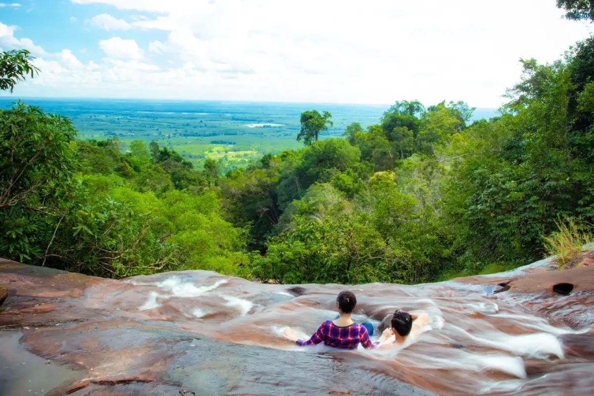
Open Days: Access is permitted on days when Phu Langka National Park officially opens the waterfall trail, excluding temporary closures for ecological restoration or visitor safety.
Opening Hours: According to the registration and trail access hours announced by Phu Langka National Park for the relevant period.
Tat Wiman Thip Waterfall in Bueng Kan Province is a spectacular seven-tiered natural waterfall within Phu Langka National Park in northeastern Thailand. Located near Ban Tat Wiman Thip in Pho Mak Khaeng Subdistrict, Bueng Khong Long District, the waterfall is renowned for its broad sandstone cliffs, cascading streams, rock terraces, and lush forest surroundings. During periods of sufficient rainfall, water spreads across the stepped rock formations, creating beautiful white curtains against the darker sandstone and surrounding vegetation. The waterfall is particularly appealing to nature enthusiasts, hikers, landscape photographers, and travelers interested in discovering the natural beauty of Bueng Kan beyond its more widely known attractions.
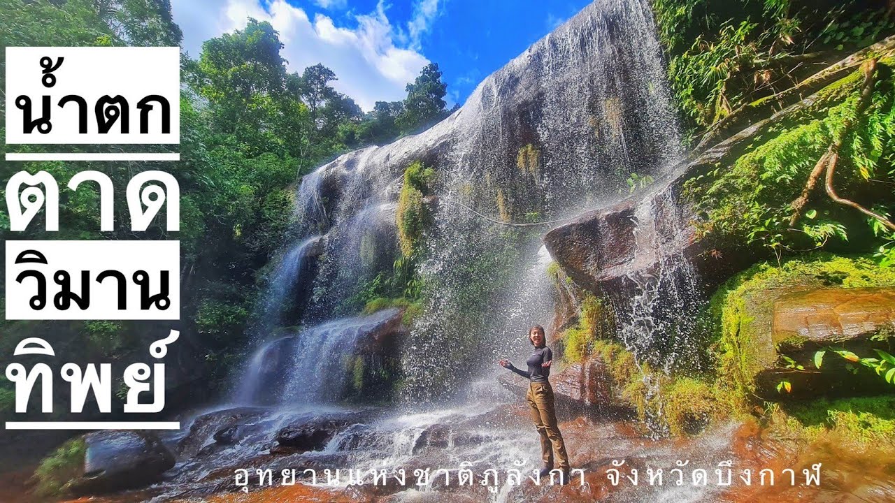
One of the most remarkable characteristics of Tat Wiman Thip Waterfall is its seven distinct tiers. Tourism descriptions record an approximate width of 150 metres and a height of 70 metres for the waterfall area. Rather than falling as a single narrow stream, the water moves across a sequence of natural sandstone steps, producing a variety of cascades, shallow channels, and broad sheets of flowing water. The changing elevations and shapes of the rock formations give each section its own appearance. Some lower sections are comparatively accessible when officially opened, whereas the upper tiers involve more demanding forest terrain and require authorized guidance.
Tat Wiman Thip is part of the natural landscape of Bueng Khong Long District, an area distinguished by the Phu Langka mountain range, sandstone formations, forest streams, caves, and the Bueng Khong Long wetland. These natural environments exist within the same general region but offer very different experiences. The mountains provide forest trails, waterfalls, and rocky cliffs, while the lowland wetland is associated with open water, local settlements, and the communities whose livelihoods are connected to the surrounding landscape.
The waterfall offers more than a scenic destination. It is an excellent example of how rainfall, forest cover, geological structure, and mountain streams interact. Rain falling over the sandstone uplands moves into natural channels and seasonal streams, gradually converging as it flows downhill. Where the landscape changes elevation, water descends over rock ledges and cliff faces, creating the sequence of cascades that defines Tat Wiman Thip.
The sandstone formations play an important role in determining how water moves through the waterfall. Broad rock surfaces allow water to spread into thin sheets, while sharper ledges produce more concentrated vertical flows. The irregular arrangement of the rock levels creates a distinctive stepped appearance. During periods of stronger flow, the waterfall resembles a series of white curtains falling over reddish-brown and dark sandstone, with moss and vegetation providing additional colour and texture.
The appearance of Tat Wiman Thip changes considerably with seasonal rainfall. When the mountain receives sufficient precipitation, the streams become more active and the waterfall's dramatic appearance is enhanced. Mist gathers around the rock ledges, and moisture-loving plants become more prominent. During dry periods, however, the water flow may diminish significantly, and some rock terraces can be exposed with little or no flowing water. This seasonal variation is a natural characteristic of the waterfall rather than an indication that the attraction has disappeared.
For visitors interested in geology, Tat Wiman Thip illustrates the formation of waterfalls in sandstone mountain environments. Over long periods, weathering, water movement, and erosion influence the shape of rock surfaces and channels. Different layers and natural fractures respond to these processes in different ways, producing ledges, grooves, and terraces. The stepped formations visible at the waterfall are therefore the result of natural geological processes rather than artificial landscaping.
The waterfall's position inside Phu Langka National Park adds to its ecological significance. The park protects important forest and mountain environments extending through parts of Bueng Kan and Nakhon Phanom provinces. Its natural features include forest streams, waterfalls, sandstone formations, and hiking routes. Attractions associated with the park include Tat Wiman Thip Waterfall, Naka Cave, Kinnaree Waterfall, and other natural destinations managed within the protected area.
Visiting a national park waterfall is different from visiting an urban recreation area. Forest routes may contain steep slopes, exposed roots, slippery stones, uneven ground, and sections affected by rapid changes in water levels. Access to particular trails must therefore follow national park safety assessments. Temporary restrictions can be introduced because of heavy rainfall, damaged paths, conservation work, or environmental restoration.
Tat Wiman Thip is also connected to the broader development of nature-based tourism in Bueng Khong Long District. The nearby Ban Tat Wiman Thip community has become associated with access routes and visitor facilities serving Phu Langka National Park, particularly the routes connected with Naka Cave. This relationship has helped introduce the area to hikers, nature enthusiasts, and travelers who visit Bueng Kan for both scenic landscapes and cultural experiences.
Naka Cave became a major attraction after public tourist access was introduced in 2020. Its sandstone formations are famous for their unusual surface patterns that resemble the scales of a large serpent. These formations have become closely associated with beliefs about the naga, a mythical serpent appearing in Thai and regional religious traditions. Interest in the cave has also increased awareness of the surrounding mountains and communities, including the Ban Tat Wiman Thip area.
Although Naka Cave and Tat Wiman Thip Waterfall are associated with the same mountain landscape, they are separate attractions with different visitor experiences. Naka Cave is primarily known for its rock formations, hiking route, and cultural symbolism. Tat Wiman Thip is characterized by streams, sandstone cliffs, and a multi-tiered waterfall. The opening of a hiking route to Naka Cave does not automatically mean that all sections of the waterfall are accessible. Each destination is subject to its own access arrangements and safety restrictions.
The experience of visiting Tat Wiman Thip begins in the communities near the base of Phu Langka. Ban Tat Wiman Thip is associated with local accommodation and services for visitors to the national park. As travelers approach the natural area, the surroundings transition from settlements and rural roads to forest vegetation, streams, and the characteristic sandstone landscape of the mountain range.
A walk through the forest offers a closer understanding of the natural surroundings than photographs alone can provide. Some trail sections have roots, fallen leaves, and uneven surfaces, while areas close to streams are often moist. Trees and smaller plants create different levels of shade, and the amount of sunlight reaching the ground varies along the route. These details contribute to the distinctive atmosphere of a forest waterfall experience.
Along the watercourses, visitors can observe changes in rock colour, texture, and vegetation. Dry sandstone looks different from surfaces continuously exposed to water, while moss-covered areas display deeper green tones. The contrast between the rock, flowing water, and surrounding foliage provides much of the scenery for which Tat Wiman Thip is known.
The lower tier introduces visitors to the waterfall's characteristic combination of sandstone terraces and flowing water. Depending on rainfall, water may pass over broad rock surfaces or descend more directly from one ledge to another. During wetter periods, the cascade extends across a larger area, while lower flows reveal more of the sandstone's natural structure. The lower levels provide an opportunity to appreciate the landscape without necessarily undertaking the more challenging ascent toward the upper tiers.
From the first tier, the natural route continues toward the second and third tiers when access is authorized. The appearance of each section changes with the elevation of the terrain, the arrangement of sandstone, and the shape of the streambed. The third tier is particularly notable for a large rock formation resembling a giant turtle swimming in the water. This unusual shape is one of the distinctive natural features associated with the waterfall.
The turtle-shaped formation illustrates how visitors interpret natural rock features through familiar shapes. Similar examples occur in sandstone landscapes elsewhere in Thailand, where weathered formations resemble animals or other recognizable objects. The appeal of this feature comes from the distinctive appearance of the rock and its position within the surrounding stream environment.
The fourth through seventh tiers are located farther uphill. Reaching these upper sections is more demanding than visiting the lower waterfall because the terrain becomes more complex. In particular, the route toward the seventh tier requires guidance from park personnel. The landscape includes elevation changes, uneven rocks, and forest paths that require appropriate preparation, sufficient time, and a suitable level of physical fitness.
The presence of seven tiers does not mean that every visitor needs to reach all seven. A visit limited to the sections officially open and suitable for individual fitness levels can still provide an excellent experience. Those primarily interested in photography, scenery, or a shorter forest excursion can appreciate the lower sections without committing to a strenuous hike.
Travelers interested in the upper tiers should arrange their visit according to national park requirements. Knowledge of the local terrain is particularly important because trails can change following heavy rain, erosion, fallen trees, or stream movement. A section that was passable during one season may become more difficult later. Authorized guides and park officers help visitors navigate these conditions and follow the approved routes.
The seasonal nature of the waterfall is another essential aspect of trip planning. Tat Wiman Thip does not have a large artificial storage system that guarantees a constant flow of water. Its dramatic appearance depends heavily on rainfall and mountain runoff. As rainfall decreases, the volume of water may fall rapidly, leaving exposed sandstone terraces. Visitors should therefore understand that the waterfall's appearance is not identical throughout the year.
During the rainy season, the Phu Langka forest is particularly green. Vegetation grows vigorously, and mosses and ferns become more noticeable in moist locations. Streams carry greater volumes of water, and the waterfall may form the broad cascades seen in photographs. These conditions create memorable scenery, but they also introduce hazards such as strong currents, slippery rock surfaces, and flash flooding.
A day immediately following intense rainfall is not necessarily the best or safest time to visit. Water levels can rise because of rainfall upstream even when there is no rain at the waterfall itself. Faster currents can also make riverbeds and rock terraces more dangerous. Park safety instructions must therefore take priority over the desire to photograph the waterfall at its most powerful.
During the cool season, Phu Langka offers a different atmosphere. Morning temperatures can be more comfortable for outdoor activities, particularly in elevated areas. The waterfall's flow depends on accumulated rainfall from the preceding months, so the broad white cascades associated with the rainy season may not always be present. Nevertheless, the mountain scenery and forest environment remain important attractions.
During the hot season, stream levels generally decrease as dry conditions develop. Some areas of vegetation change appearance, and exposed rock surfaces can become more prominent. This season reveals the structure of the sandstone terraces, but visitors hoping to see a powerful waterfall should take its rainfall-dependent character into account.
Tat Wiman Thip is especially attractive to landscape photographers because of its variety of natural compositions. Sandstone cliffs, cascading streams, rock terraces, moss, ferns, and surrounding trees create multiple visual layers. Photographs can emphasize the breadth of the waterfall, the successive elevations of its tiers, or the contrast between flowing water and textured rock.
When water flow is sufficient, the white cascades contrast strongly with the darker rock surfaces and the green forest. Sunlight filtering through the canopy can create additional patterns of light and shadow. Excellent photographs can be taken from stable, authorized viewpoints without standing in flowing water or approaching hazardous cliff edges.
Visitors should remember that attractive rock ledges are not necessarily safe places to stand. Moss-covered sandstone can be extremely slippery, even when only a small quantity of water is present. Some surfaces slope toward streams or abrupt drops and provide limited grip. Photography and sightseeing should always take place within the areas designated as safe by park staff.
The experience of Tat Wiman Thip can be enjoyed by spending time observing the lower waterfall and its surroundings. The sound of moving water, the texture of the rocks, the coolness of shaded areas, and the changes in vegetation all contribute to a rewarding encounter with nature. Reaching the highest tier is not the only measure of a successful visit.
The surrounding forest also supports the mountain's headwater ecosystem. Trees, shrubs, and smaller plants help retain moisture, reduce soil erosion, and provide habitats for wildlife. Trampling delicate vegetation, removing plants, or leaving litter along streams can harm these ecological processes. Responsible tourism is particularly important in areas that receive large numbers of visitors during popular travel periods.
Exploring the Phu Langka area also provides insight into the relationship between protected forests and nearby communities. Healthy forests contribute to the local water system and preserve natural resources, while communities provide accommodation, meals, and visitor services. Sustainable tourism depends on maintaining this balance between conservation and appropriate economic activity.
Ban Tat Wiman Thip is closely associated with the national park's tourism network, including the temporary ranger station area and access arrangements linked to Naka Cave. As interest in Phu Langka has increased, small accommodation providers and local businesses have developed services for travelers. These include homestays, guesthouses, and other establishments catering to visitors who wish to stay close to the mountain.
Homestays around the foothills are particularly useful for visitors planning an early start. Accommodation varies from private rooms and small houses to facilities suitable for groups. Staying near the park reduces the need for a long drive before a morning hiking activity, especially when a route has specific registration requirements.
The area also has a cultural dimension connected with naga beliefs in northeastern Thailand and the Mekong region. Naka Cave is an important example of how an unusual geological landscape becomes associated with local religious imagination and cultural traditions. Tat Wiman Thip, by contrast, is primarily appreciated for its natural environment. Visiting both destinations reveals the different ways in which the Phu Langka landscape is valued.
Bueng Khong Long itself provides another important dimension of the region's natural heritage. The large wetland is one of Bueng Kan's notable natural environments and contrasts with the upland forests of Phu Langka. The lake landscape is associated with open water, surrounding settlements, and local livelihoods. Combining the mountain area with the wetland allows travelers to experience two contrasting ecosystems within the same district.
Travelers considering both Tat Wiman Thip and Naka Cave should account for the physical demands and access requirements of each route. Naka Cave involves a substantial hike, and completing two demanding outdoor activities on the same day may not be practical. Registration times, trail restrictions, weather, and available daylight should all influence the itinerary. Long forest hikes should not be started late in the afternoon.
Kinnaree Waterfall is another natural attraction within the Bueng Kan section of Phu Langka National Park. Located near Ban Na Ang in Pho Mak Khaeng Subdistrict, it is associated with a stream and sandstone landscape. Visitors interested in several waterfalls can consider it as part of a wider nature itinerary, subject to the opening status and access conditions of each site.
Tat Kham Waterfall is another attraction associated with Phu Langka National Park. It offers an additional opportunity to encounter forest streams and natural rock formations. However, the entrances, trails, and access restrictions of the park's waterfalls are not necessarily the same. Each visit should be planned according to the appropriate location rather than treating the entire national park as one continuous visitor route.
Travelers exploring Bueng Kan more widely can also consider Phu Thok and Phu Wua Wildlife Sanctuary. Phu Thok is known for its cliffside wooden walkways and Buddhist meditation setting, while Phu Wua is a protected natural area with forests and sandstone terrain. These attractions are situated in other parts of the province and are better incorporated into a multi-day itinerary than a rushed single-day excursion.
Grouping attractions by geographical area helps make a Bueng Kan trip more practical. The Bueng Khong Long area is well suited to an itinerary focused on Phu Langka, Naka Cave, waterfalls, and the wetland. Phu Thok and Phu Wua can form another section of a broader journey. This approach reduces unnecessary travel and leaves more time for experiencing each destination.
Families should carefully consider the abilities and mobility of all participants. Although waterfall photographs may suggest a relaxed recreational setting, the actual hiking environment can include sloping paths, uneven stones, and slippery surfaces. Steep or climbing-intensive routes are not suitable for every traveler, especially young children, older visitors, and people with mobility limitations. The most appropriate experience is the one that matches the abilities of the group and the park's current access arrangements.
Suitable footwear is essential for forest walking. Shoes should have reliable grip on wet or uneven surfaces, while clothing should allow comfortable movement in hot and humid conditions. Drinking water, essential medication, and rain protection are important personal supplies. Phones, cameras, and other electronic devices should be protected against rain and splashing water.
Before starting a hike, visitors should contact park personnel and use only officially authorized routes. Closed paths, warning signs, and barriers must be respected even if photographs or older travel reports show people previously entering those areas. Trail conditions and safety regulations can change, and following park instructions helps protect both visitors and the environment.
Swimming should never be assumed safe simply because a stream appears shallow or calm. Watercourses may contain deep grooves, slippery submerged rocks, and currents that change rapidly. Entering the water is appropriate only where national park staff expressly permit it and where current safety conditions allow.
Environmental responsibility is central to visiting a protected waterfall. All litter should be carried out, food waste should never be left in the forest, and plants, rocks, and other natural objects should remain undisturbed. Visitors should not carve or write on trees and rock surfaces. Remaining on designated routes also reduces damage to delicate vegetation and sensitive streamside habitats.
The peaceful forest atmosphere is one of Tat Wiman Thip's most valuable qualities. Running water, insects, birds, and wind moving through the canopy create a natural soundscape very different from urban attractions. Avoiding excessive noise and disturbance allows visitors to appreciate the surroundings while respecting wildlife and other travelers.
Tat Wiman Thip Waterfall is managed by Phu Langka National Park under Thailand's Department of National Parks, Wildlife and Plant Conservation. The park is responsible for natural resource protection, trail access, visitor safety, conservation work, and management of the protected area. Temporary closures serve important purposes, including accident prevention, trail repairs, ecological recovery, and protection of fragile environments.
For the 2026 tourism season, Phu Langka National Park reopened Naka Cave on 1 June 2026 after its annual conservation closure in May. Other attractions within the park operate under access arrangements appropriate to their individual trails. Waterfall access remains subject to weather, safety assessments, and announcements by park management.
Visitors should distinguish the operating hours of the national park office from registration and entry times for individual attractions. Different routes require different amounts of time and involve different terrain. The opening of one attraction does not automatically authorize access to another trail. Entry to Tat Wiman Thip must follow the instructions issued for the waterfall area.
Admission to attractions inside Phu Langka National Park is governed by the national park fee system. Fees vary according to visitor category and vehicle type. Certain routes may also require guide services or other arrangements. The charges applicable to a particular visit depend on the authorized activity, entry point, and current park regulations.
Visitors have several accommodation options around Bueng Khong Long, including homestays, guesthouses, and resorts. Ban Tat Wiman Thip and Pho Mak Khaeng Subdistrict are convenient bases for travelers wishing to stay near the mountain. Accommodation closer to the district centre is another option for visitors who prefer access to a wider selection of local restaurants and services.
Dining options in the wider Bueng Khong Long area include northeastern Thai dishes, made-to-order meals, noodle restaurants, and cafes. Having a suitable meal before a long hike helps visitors prepare for physical activity, while local restaurants provide convenient places to rest afterward. These businesses also form part of the local tourism economy surrounding Phu Langka.
For a day trip, it is sensible to focus on one or two main activities rather than attempting to visit every attraction in the district. When the waterfall route is open, Tat Wiman Thip can be the primary destination, followed by a more relaxed visit to Bueng Khong Long or another accessible attraction. This approach offers time to enjoy the natural environment without an unnecessarily rushed schedule.
A two-day, one-night itinerary provides more flexibility for travelers arriving from distant provinces. The first day can be devoted to reaching Bueng Khong Long, settling into accommodation, and exploring the local community. The following morning can then be reserved for outdoor activities. This arrangement avoids beginning a demanding hike immediately after a long drive and provides flexibility if weather conditions change.
Photographers should approach the waterfall with realistic expectations about seasonal conditions. The strongest flow may occur at a time when certain routes are unsafe or closed. Conversely, a day with easier access may reveal a quieter waterfall and more exposed sandstone. The scenery remains valuable for its cliffs, terraces, forest vegetation, and geological features even when the water flow is modest.
Tat Wiman Thip also offers an opportunity to understand headwater ecology. Water movement, rock slope, and vegetation are closely connected. Areas exposed to fast currents differ from places where water moves slowly or moisture accumulates. Observing these natural variations reveals how the waterfall and surrounding forest function as a connected system.
Within the wider tourism landscape of Bueng Kan, Tat Wiman Thip represents the province's sandstone mountain and forest-waterfall environment. It offers a contrasting experience to the Mekong River, urban attractions, and cultural landmarks elsewhere in the province. This diversity makes Bueng Kan a rewarding destination for travelers who want to explore both natural heritage and local communities.
Getting There Tat Wiman Thip Waterfall can be approached by private car or rental vehicle through Bueng Khong Long District in Bueng Kan Province. Travelers should continue toward Pho Mak Khaeng Subdistrict and Ban Tat Wiman Thip, the foothill community associated with the national park access area. From Bueng Kan town, Highway 212 connects with the road network leading toward Bueng Khong Long. Local roads then provide access to the Ban Tat Wiman Thip area and the appropriate national park contact point.
On arrival at the ranger station or visitor contact area, travelers must confirm which waterfall routes are officially open before entering the forest. Naka Cave registration arrangements and waterfall access requirements are separate. Reaching the upper waterfall tiers requires authorized guidance, and visitors must not enter closed or undesignated trails.
Tat Wiman Thip Waterfall is one of the distinctive natural attractions of the Phu Langka landscape. Its seven cascading tiers, sandstone cliffs, forest streams, and seasonal scenery demonstrate the ecological and geological richness of Bueng Kan Province. Beyond the beauty of the flowing water, the destination highlights the importance of protecting forests, mountain headwaters, and surrounding communities. By observing national park regulations and treating the environment responsibly, visitors can experience this remarkable part of northeastern Thailand while helping preserve it for future generations.
| Name | Tat Wiman Thip Waterfall |
| Location | Phu Langka National Park, Bueng Khong Long District, Bueng Kan Province, Thailand |
| Address | Ban Tat Wiman Thip, Pho Mak Khaeng Subdistrict, Bueng Khong Long District, Bueng Kan 38220, Thailand |
| Attraction Type | Natural waterfall and ecotourism attraction within a national park |
| Highlights | Seven cascading tiers, wide sandstone cliffs, natural rock terraces, seasonal curtains of water, and lush forest scenery |
| Waterfall Dimensions | Tourism descriptions report an approximate width of 150 metres and a height of 70 metres |
| Main Areas / Zones | Lower tiers 1–3, the turtle-shaped rock formation at tier 3, upper forest routes toward tiers 4–7, and the temporary national park ranger station area. Access depends on official trail openings. |
| Geological Features | Sandstone mountains, stepped rock ledges, cliffs, natural stream channels, and weathered rock formations |
| Best Visiting Period | Rainy-season periods with suitable water flow and safe weather conditions, subject to the park's opening announcements |
| Open Days | On days when Phu Langka National Park officially permits access to the waterfall trail |
| Opening Hours | According to the current registration and trail access schedule announced by park staff |
| National Park Fees | Published Phu Langka National Park rates: Thai adults 20 baht, Thai children 10 baht; foreign adults 100 baht, foreign children 50 baht; four-wheel vehicles 30 baht and motorcycles 20 baht. Route-specific admission and guide charges are subject to current park regulations. |
| Management | Phu Langka National Park, Department of National Parks, Wildlife and Plant Conservation |
| National Park Chief | Mr. Aksorn Manawong (named in the Department of National Parks announcement of May 2026) |
| Contact Number | Phu Langka National Park: +66 42 530 766 |
| Travel Information | Travel to Pho Mak Khaeng Subdistrict, Bueng Khong Long District, then continue toward Ban Tat Wiman Thip and the national park visitor contact area |
| Activities | Nature sightseeing, hiking on officially opened trails, sandstone landscape observation, and waterfall photography |
| Safety Considerations | Slippery rocks, flash floods, steep terrain, and elevated cliff areas. Visitors must not enter closed trails. |
| Nearby and Connected Attractions | 1. Naka Cave, Phu Langka National Park 2. Kinnaree Waterfall, Ban Na Ang 3. Bueng Khong Long Wetland 4. Tat Kham Waterfall, Phu Langka National Park 5. Kinnaree Naka Cave, Phu Langka area |
| Restaurants in the Surrounding Area | 1. Baan Suan Tang Su Ma Restaurant, Pho Mak Khaeng Subdistrict 2. The Country Side, Bueng Khong Long, Tel. +66 96 269 8914 3. Nua @ Naka Station, Tel. +66 92 356 5366 4. Phu Wua Coffee, Seka District 5. Bueng Khong Long Cafe, Tel. +66 97 318 2200 |
| Accommodation in the Surrounding Area | 1. Tat Wiman Thip Homestay, Ban Tat Wiman Thip, Tel. +66 89 274 5443 2. Alinda House, Ban Tat Wiman Thip, Tel. +66 81 913 8523 3. Phu Langka View Homestay, Naka Cave access area, Tel. +66 89 712 3292 4. Npu Homestay Naka Cave, Tel. +66 88 970 8057 5. HR Resort, Pho Mak Khaeng Subdistrict, Tel. +66 99 735 8789 |
Frequently Asked Questions (FAQ)
Q: Where is Tat Wiman Thip Waterfall located?
A: Tat Wiman Thip Waterfall is located in Phu Langka National Park near Ban Tat Wiman Thip, Pho Mak Khaeng Subdistrict, Bueng Khong Long District, Bueng Kan Province, northeastern Thailand.
Q: How many tiers does Tat Wiman Thip Waterfall have?
A: The waterfall has seven tiers, each with different sandstone formations and water features. The third tier is known for a turtle-shaped rock formation, while access to the seventh tier requires authorized guidance.
Q: What is the best time of year to visit Tat Wiman Thip Waterfall?
A: The rainy season generally offers greener forests and a greater chance of substantial water flow. Visitors must choose days when weather conditions are safe and the national park has officially opened the trail.
Q: Is Tat Wiman Thip Waterfall open every day?
A: Access depends on Phu Langka National Park announcements and safety assessments. Trails can close temporarily because of heavy rainfall, ecological restoration, or unsafe conditions. The park can be contacted at +66 42 530 766.
Q: Is there an entrance fee for Tat Wiman Thip Waterfall?
A: Entry is subject to Phu Langka National Park regulations and its fee system. Charges vary for Thai and foreign visitors, vehicles, and route-specific services where applicable.
Q: Can visitors explore all seven waterfall tiers independently?
A: Access to the upper tiers, particularly the seventh tier, requires authorized park guidance. Visitors may enter only the trails that Phu Langka National Park has officially opened.
Q: Are Tat Wiman Thip Waterfall and Naka Cave in the same area?
A: Both attractions are within the Bueng Khong Long section of Phu Langka National Park. Ban Tat Wiman Thip is associated with access arrangements for Naka Cave, but each attraction has separate trail requirements and access restrictions.
Q: Are there accommodations near Tat Wiman Thip Waterfall?
A: Yes. Homestays and guesthouses are available around Ban Tat Wiman Thip and Pho Mak Khaeng Subdistrict, including Tat Wiman Thip Homestay, Alinda House, and Phu Langka View Homestay. Additional accommodation options are available elsewhere in Bueng Khong Long District.
 Category: ●Nature and Wildlife
 Group: ●Waterfalls
Last Update : 2 WeekAgo
 Last Update : 2 WeekAgo
 Click to Access the Navigation Map GPS
Tat Wiman Thip Waterfall Map
Recommend

 Art, Culture and Heritage
 Landmarks and Memorials(1)
 Museums(1)
 Places of Worship
 Temple(12)
 Other Sacred Sites(4)
 Suburban Living
 Local Market(1)
 National Parks and Marine Reserves(1)
 Mountain (Doi)(3)
Waterfalls(5)
 Caves(1)
 River, Canal(4)
 Bays and Beaches(1)
 Islands(1)
 Entertainment and Agricultural
 Waterpark(1)
 Shopping
 Shopping and Night Market(1)
 Travel Articles, Recipes
 Travel Review, Food Review(1)


