
lovethailand home >Northeastern Travel Attractions >Bueng Kan Travel Attractions >Seka >Ban Tong > Chet Si Waterfall
TL;DR: Chet Si Waterfall, Bueng Kan attractions : Nature and Wildlife, Waterfalls.

Chet Si Waterfall
Open Days: Access is subject to Phu Wua Wildlife Sanctuary announcements and prevailing safety conditions
Opening Hours: 08:30 – 17:00 according to published visitor information
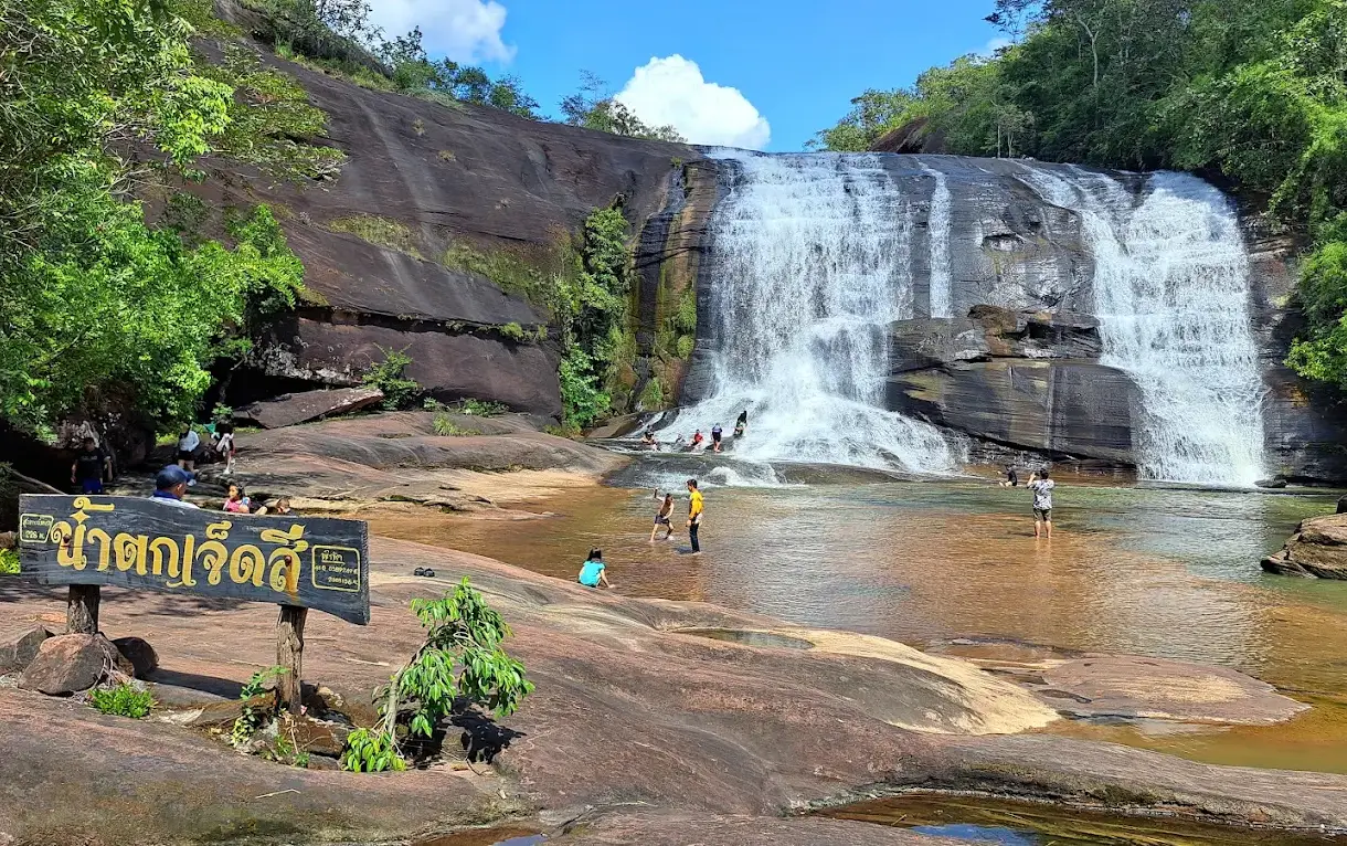
Chet Si Waterfall in Bueng Kan Province, Thailand is a distinctive natural attraction known for the broad curtains of water descending over a high sandstone cliff within the forested landscape of Phu Wua Wildlife Sanctuary. Located near Ban Don Siat in Ban Tong Subdistrict, Seka District, Bueng Kan Province, the waterfall is formed by water flowing from Huai Ka-am, a stream that crosses sandstone terrain before descending over a series of rock ledges. As the water strikes rocks below, it produces fine spray that can reveal rainbow colors when illuminated by sunlight from a suitable angle. This natural optical phenomenon inspired the name Chet Si, meaning Seven Colors. Beyond the possibility of seeing rainbows, the destination offers scenic sandstone formations, forest streams, natural pools, and a walking route that introduces visitors to the rich natural environment of northeastern Thailand.
The waterfall was traditionally known as Huai Ka-am Waterfall, or Ka-am Waterfall, after the stream that supplies its water. Its later name, Chet Si Waterfall, reflects the colorful effect created when droplets of water scatter sunlight near the cascades. The relationship between the original geographical name and the more descriptive modern name is part of the attraction's identity. Both names refer to the same natural landscape, but one emphasizes its water source while the other highlights the appearance that makes it memorable to visitors.
The outstanding character of Chet Si Waterfall results from the interaction of three natural elements: sandstone, flowing water, and sunlight. The rock structure determines how water moves down the slope, the current produces cascades and spray, and sunlight makes it possible for water droplets to display rainbow colors. The conditions must align for the colors to become clearly visible. Weather, the position of the observer, the direction of the sun, and the amount of spray all influence the appearance. Even when no rainbow is visible, the waterfall remains attractive because of its broad cascades, sandstone cliffs, and surrounding forest.
Chet Si Waterfall lies within Phu Wua Wildlife Sanctuary, a major conservation area in Bueng Kan Province. The sanctuary covers approximately 116,562 rai, or about 186 square kilometers, and includes forest and sandstone mountain terrain across several districts. The landscape contains cliffs, exposed rock platforms, woodland, and natural streams that form waterfalls at changes in elevation. Chet Si is one of the sanctuary's recognized natural attractions. The area surrounding the waterfall is managed by the Don Siat Forest Protection Unit under the sanctuary's administration.
Being located within a wildlife sanctuary means that Chet Si Waterfall is subject to different management priorities from a conventional public park. The sanctuary's primary purpose is to protect wildlife, native plants, and the natural ecosystems on which they depend. Visitor access, walking routes, recreational activities, and swimming must therefore comply with rules established by the responsible authorities. Restrictions may be introduced when natural conditions become dangerous or when activities could disturb the protected environment. Preserving the waterfall requires conserving the broader forest landscape rather than managing the cascade in isolation.
The community of Ban Don Siat in Ban Tong Subdistrict is closely connected with the waterfall through its location along the access route. The village serves as an important geographical reference for travelers approaching the forest. The journey from local roads into the conservation area reveals a transition between settled and agricultural landscapes and the natural sandstone hills farther inland. This relationship gives tourism a local dimension through road access, visitor services, and the shared responsibility of maintaining an orderly environment around the attraction.
The geological landscape of Chet Si Waterfall developed through the long-term weathering and erosion of sandstone. Sandstone is a sedimentary rock formed when layers of sand accumulate and become compacted and cemented into solid material. Once exposed at the Earth's surface, rainfall, flowing water, and temperature changes gradually affect the rock. Less resistant sections erode more rapidly than stronger portions, creating ledges, channels, and changes in elevation. These features provide the physical foundation for the waterfall and influence how the stream moves across the terrain.
Huai Ka-am is the stream responsible for shaping the waterfall's distinctive appearance. As water flows from higher terrain toward the sandstone ledges, it changes from a relatively level stream into a cascade descending across the cliff. Gravity accelerates the flow along steeper sections. When water strikes rocks below, it breaks into small droplets and creates mist. During periods of substantial flow, the width of the cliff allows the water to spread across a broad area, forming an impressive curtain of white cascades.
Fine water spray is a common natural feature around powerful waterfalls. When rapidly flowing water collides with rock surfaces, it fragments into numerous small droplets. These droplets may remain suspended in the air briefly before returning to the ground. Sunlight entering the droplets undergoes refraction and internal reflection, separating into different colors under suitable viewing conditions. This process explains the rainbow phenomenon associated with Chet Si Waterfall and provides a visible example of how light interacts with water in the natural environment.
Despite the name Seven Colors, a rainbow does not appear continuously throughout the day or on every visit. Its visibility depends on the direction and angle of sunlight, the observer's position, and the density of spray. On some occasions, colorful bands may appear clearly, while at other times only white mist is visible near the rock face. These changing conditions are part of the waterfall's natural character. Visitors can still enjoy the cliffs, forest scenery, and flowing water even when the distinctive rainbow effect is absent.
Geographically, Chet Si Waterfall descends through several sections of sandstone terrain. Some sections include exposed rock platforms and pools, while others feature higher cliffs where water strikes lower rocks and produces more visible spray. Walking along permitted routes allows visitors to observe how the stream changes with each shift in elevation. In places, the flow moves across relatively broad ledges before descending again. These different features create varied scenery within one waterfall system.
The lower sections include streams and pools formed as water collects and moves away from the higher cascades. The shapes of the pools depend on the underlying sandstone and the natural slope. Some surfaces are relatively smooth, while others contain cracks and smaller stones. Observing the lower pools reveals how stronger descending currents become stream flow along the valley floor. Nevertheless, pool depth and current strength can vary with rainfall, and visitors must remain within the areas approved by sanctuary staff.
Farther along the waterfall route, larger sandstone cliffs become more prominent. Water spreads from the upper ledges and descends toward lower levels, forming pale curtains against reddish-brown rock. Fine spray may collect around the cliff, darkening the wet sandstone and creating a cooler, more humid atmosphere. Trees along the stream provide green surroundings that contrast with the exposed stone. The scenery combines water, rock, and vegetation in a way characteristic of the sandstone landscapes of northeastern Thailand.
Visiting different levels of the waterfall requires attention to the condition of the natural trail. Some sections pass across uneven stones, channels, and sloping ground. Routes toward higher parts of the waterfall may involve greater physical effort and require better balance than those around the lower stream. Wet weather increases the risk of slipping. Visitors should therefore remain on designated paths and avoid climbing toward exposed ledges or cliff edges simply to obtain a different photograph.
Access to Chet Si Waterfall requires a walk from the vehicle parking area. Published route descriptions give different walking distances depending on the starting point and how many waterfall sections are included. Some describe approximately 800 meters to the first section, with additional walking required to reach higher levels, while local information describes a total walking distance of around 1.5 kilometers. Walking is therefore an essential part of the visit. The attraction is not a roadside viewpoint where visitors can park directly beside the cascade.
The approach trail provides an opportunity to experience the forest environment of Phu Wua. Trees shade portions of the route, while exposed sandstone platforms reveal the geological structure of the mountain. The landscape changes between woodland and more open rock surfaces. Running water may be heard from nearby channels, and elevated sections offer views of surrounding vegetation and hills. Reaching the waterfall is therefore part of a wider nature experience rather than simply a short transfer from the parking area.
Phu Wua contains several types of forest, including dry dipterocarp forest, dry evergreen forest, and more humid vegetation in areas with suitable environmental conditions. Plants vary according to soil, moisture, and elevation. Streams and waterfalls create locally moist habitats that differ from exposed sandstone areas with shallow soils. Walking through these environments helps visitors see how water availability affects the distribution of vegetation, particularly near the stream and beneath the forest canopy.
The surrounding forest plays an important role in maintaining the mountain's soil and water system. Tree roots help stabilize soil, while leaf litter and organic matter influence how rainfall enters and moves across the ground. During wet weather, water from the uplands collects in streams and changes the volume of the waterfall. Forest conservation is therefore connected with the health of the waterways and the broader ecosystem. Protecting Phu Wua helps preserve the environmental conditions that make Chet Si Waterfall valuable as a natural attraction.
The rainy season is generally the most impressive period for viewing the broad waterfall curtains. Increased rainfall across the uplands feeds Huai Ka-am and causes more water to spread across the sandstone cliff. The forest becomes greener, and the landscape takes on a lush appearance. On suitable days, abundant spray near the base of the cliff can produce a vivid rainbow effect when sunlight reaches the droplets at the right angle.
The rainy season is also the period when safety requires the greatest attention. Heavy or prolonged rain in the upper catchment can rapidly increase stream levels. Currents may become stronger than they appear from a distance, and channels or natural pools may develop dangerous flows. Cloudy water carrying natural debris can indicate changing conditions. Crossing streams or approaching the edge of a cascade during high water is particularly hazardous.
Waterfall management at Phu Wua Wildlife Sanctuary includes temporary closures when flash flooding creates unacceptable risk. In August 2023, Chet Si Waterfall and other attractions within the sanctuary were closed temporarily following heavy rainfall. Access reopened after water levels returned to more suitable conditions. The incident demonstrates why management must respond to actual water conditions and why the decision to admit visitors cannot be separated from safety.
Travel to Chet Si Waterfall is subject to the realities of a natural environment that can change significantly during the year. Unlike an urban park, the attraction includes forest paths and stream channels influenced by rainfall. Opening the general visitor area does not necessarily mean that every trail or swimming location is accessible. Visitors must follow the areas designated by staff and comply with any temporary restrictions on higher waterfall sections or water activities.
During the drier months, water flow can become considerably lower. Sections of rock previously covered by cascades may become exposed, revealing the detailed shapes of the sandstone and the channels carved by water. The landscape may still be geologically interesting, but the broad water curtain and rainbow effect may be less prominent. The waterfall should therefore be understood as a seasonal natural environment rather than a place where the same scenery is guaranteed every month.
Sandstone surfaces near the cascade require particular caution. Rocks that remain wet may become slippery because of algae, moisture, or fine sediment. Some sections have grooves and sudden changes in level that are difficult to recognize when water covers the ground. Well-fitting footwear with reliable grip is preferable to loose sandals or smooth-soled shoes. Paying attention to each step is essential when moving across exposed natural rock.
Anyone wishing to enter the water must remain within permitted areas. Natural pools do not have uniform depth or consistent underwater surfaces. Submerged stones and narrow channels may be difficult to see, while currents can change rapidly after rainfall. Jumping from rocks into unfamiliar water or sliding along sandstone without understanding the landing area creates unnecessary danger. Images of recreational activities from previous years should never be treated as evidence that the same place is safe under current conditions.
Families with young children should provide close supervision throughout the visit, especially near wet sandstone and streams. Children may be unable to judge water depth or current strength and may not recognize dangerous cliff edges. Selecting safe viewing and resting areas allows families to enjoy the natural setting without requiring everyone to swim or approach the most exposed parts of the waterfall.
Older adults and travelers with mobility limitations should consider the walking route before visiting. Natural paths may include uneven surfaces, slopes, and wet rock. Reaching higher waterfall sections can require additional effort and balance. It is reasonable to enjoy the forest and accessible viewpoints without attempting every level. Choosing an activity appropriate to personal mobility helps make the excursion safer and more comfortable.
Chet Si Waterfall provides attractive opportunities for landscape photography. When water flow is high, pale curtains of cascading water contrast with darker wet sandstone and lush green forest. Photographs taken from stable positions can capture the cliff, the falling water, and the surrounding vegetation together. Rainbows created by spray may appear under suitable lighting conditions, adding a distinctive visual element that changes throughout the day.
The detailed surfaces of the sandstone are also interesting photographic subjects. Natural fractures, water channels, and variations in rock texture reveal the effects of erosion and weathering. Small plants growing in moist crevices create additional color and detail. These features can be observed from approved paths without walking into dangerous channels or approaching the edge of a high cliff.
Maintaining cleanliness is an essential responsibility within Phu Wua Wildlife Sanctuary. Litter left in the forest can be washed into streams during rainfall, affecting aquatic organisms and the surrounding ecosystem. Food packaging, bottles, and other waste must be taken out of the protected area or placed in appropriate collection points. Discarding waste into water can cause it to accumulate between rocks or in downstream areas where removal becomes difficult.
Sanctuary regulations also protect natural rock surfaces and the quiet environment. Visitors must not carve or write on sandstone, damage plants, disturb wildlife, or engage in prohibited activities. Excessive noise can affect other visitors and disrupt the atmosphere of the forest. Respect for these rules helps protect both the visual quality of the waterfall and the ecological value of the wider conservation area.
Chet Si Waterfall has a local economic role because visitors travel through communities in Seka District and may use nearby restaurants, accommodation, and shops. Tourism can provide opportunities for local services, but it must develop alongside environmental protection. Maintaining clean roads and waterways, respecting residential areas, and following forest regulations help balance visitor activity with the everyday lives of surrounding communities.
Phu Wua Wildlife Sanctuary is much more than the location of Chet Si Waterfall. It contains other notable cascades and protected forest landscapes. Tham Phra Waterfall is particularly well known for its broad sandstone platforms, natural water channels, and boat-based approach through a forest waterway. These features create a different travel experience from the walking trail and cliff cascades at Chet Si, even though both attractions belong to the same protected landscape.
Tham Fun Waterfall is another natural attraction within Phu Wua. Its waters descend over sandstone terrain in the northern part of the mountain environment, becoming more visible during periods of substantial rainfall. The access route is separate from that of Chet Si, so the waterfalls should not be assumed to be connected by a short pedestrian path. Visiting both requires adequate travel time and compliance with the available routes.
Tat Nok Khian Waterfall is another site managed within the Phu Wua conservation area. It has appeared alongside Chet Si, Tham Phra, and Tham Fun in official announcements concerning access restrictions and reopening. The presence of several waterfalls illustrates the diversity of streams and sandstone landforms across the sanctuary. Each cascade is shaped by its own geological setting and watercourse.
Beyond the waterfalls, Phu Wua contains sandstone ridges, rock platforms, and forest landscapes visible from approved nature-study routes. These features provide a broader perspective on the relationship between upland drainage and the lower streams. Access to ridges and forest sections remains controlled because a wildlife sanctuary is not an unrestricted hiking area. The broader landscape can be explored only through the routes and activities permitted by the responsible authorities.
Phu Thok in Si Wilai District is another significant attraction in Bueng Kan Province. It is a sandstone mountain with wooden walkways built along the cliffs and has an important connection with Luang Pu Juan Kulachettho, a respected monk in Thailand's forest meditation tradition. Phu Thok combines a dramatic geological setting with Buddhist cultural history, offering a different experience from the forest streams and waterfalls of Phu Wua.
Bueng Khong Long is a major freshwater wetland in Bueng Kan Province. Its open-water landscape differs considerably from the forested slopes of Phu Wua. The wetland is important for aquatic ecosystems and local communities, and it also provides opportunities for scenic recreation. Combining the waterfall with Bueng Khong Long allows travelers to experience both upland streams and a broad freshwater basin during a visit to the province.
Hat Kham Somboon is a recreational lakeside area along Bueng Khong Long. Its freshwater beach setting offers a different form of relaxation from the forest walking route at Chet Si Waterfall. Visiting both locations reveals the contrast between water flowing through sandstone mountains and a large lake surrounded by communities and open scenery.
Naka Cave in Phu Langka National Park is another well-known destination in Bueng Kan. It attracts visitors because of sandstone patterns resembling the scales of the mythical Naga serpent and local traditions associated with the landscape. Reaching the cave requires an uphill forest trek and compliance with national park regulations, making it a separate major excursion rather than a short stop immediately following a waterfall visit.
Travel in Seka District also offers opportunities to experience rural communities near the Phu Wua forest. Restaurants in the district serve northeastern Thai food, including som tam, laab, and everyday local dishes. Dining in nearby communities before or after entering the conservation area reduces the need to carry excessive food into the forest and supports local businesses.
Accommodation in Seka District can be convenient for visitors arriving from other provinces and planning a morning excursion to Chet Si Waterfall. Staying in the district center provides access to shops, restaurants, and roads leading toward Ban Tong Subdistrict. Travelers continuing to Bueng Khong Long or Naka Cave should allow sufficient time for road travel between districts rather than assuming that all attractions in Bueng Kan are closely grouped together.
As an educational destination, Chet Si Waterfall brings together several important subjects: sedimentary rock formation, water erosion, the interaction of light with fine spray, upland forest ecology, and wildlife conservation. Observing these processes directly helps visitors understand how the waterfall's remarkable appearance emerges from natural conditions rather than from a single isolated feature. The destination therefore provides value for students, nature enthusiasts, and general travelers alike.
The waterfall also illustrates the importance of streams within sandstone mountain ecosystems. Huai Ka-am carries water from higher slopes toward lower terrain, gradually shaping channels and transporting sediment. The same watercourse supports plants and organisms associated with the stream environment. Protecting water quality is therefore essential both for biodiversity and for the long-term value of the attraction.
Managing visitor numbers is another important consideration, especially where paths are narrow or where people gather near strong currents. Crowding on wet rock platforms can increase the risk of slipping or falling. Designated trails and staff supervision help distribute visitors and protect sensitive natural areas. Responsible access is essential to prevent tourism from damaging the very environment that makes the waterfall attractive.
Safety at Chet Si Waterfall depends on cooperation between sanctuary personnel and visitors. Officials assess water conditions and determine whether individual areas can be opened. Visitors must follow signs, avoid restricted sections, and respect instructions concerning swimming or walking near cascades. These measures reduce risks and allow staff to focus on the protection of both travelers and wildlife.
The waterfall's lasting value lies in the relationship between its sandstone cliffs, flowing water, and surrounding forest. Without the upland ecosystem and the seasonal flow of Huai Ka-am, the broad water curtain and spray associated with the site would be very different. Conservation must therefore address the whole natural landscape, not merely the specific point from which tourists photograph the waterfall.
Getting There: Chet Si Waterfall can be reached by private car or rental vehicle through Seka District, Bueng Kan Province. Continue toward Ban Tong Subdistrict and Ban Don Siat using the local road network. Published directions describe an approach via Ban Chaiyaphon and Ban Thung Sai Chok toward Ban Don Siat, followed by a local turn toward the waterfall. After reaching the vehicle access and parking area, visitors continue on foot along the designated nature route. The walking distance depends on which section of the waterfall is open and how far visitors intend to explore.
Travelers arriving from other districts of Bueng Kan can use the regional road network to reach Seka before continuing toward Ban Tong. It is important to distinguish the driving distance to the trailhead from the walking distance within the sanctuary. The two parts of the journey have different conditions and time requirements. Travelers combining multiple waterfalls should also account for their separate access roads rather than assuming that they can all be reached on foot from one location.
Morning visits allow more time to explore approved trails and return before the end of the visitor operating period. Rain and changes in water level can affect the suitability of individual routes, so access must follow the decisions of sanctuary personnel. Allowing sufficient time for walking helps visitors appreciate the scenery without rushing through slippery or uneven natural terrain.
Chet Si Waterfall is a remarkable expression of Bueng Kan's natural heritage. Water from Huai Ka-am descends over broad sandstone cliffs and creates fine spray that can reveal rainbow colors under suitable sunlight. The combination of cascading water, rock platforms, streams, and the forests of Phu Wua provides opportunities for recreation, photography, and environmental learning. As an attraction within a wildlife sanctuary, its protection and safe management are essential. Chet Si is therefore more than a waterfall with a memorable name: it is a place where sandstone, flowing water, sunlight, and forest ecology combine to create one of the distinctive natural landscapes of upper northeastern Thailand.
| Place Name | Chet Si Waterfall, also known as Huai Ka-am Waterfall |
| Address | Ban Don Siat, Ban Tong Subdistrict, Seka District, Bueng Kan Province 38220, Thailand |
| Attraction Type | Waterfall and nature-study route within a wildlife sanctuary |
| Protected Area | Phu Wua Wildlife Sanctuary |
| Responsible Authority | Don Siat Forest Protection Unit, Phu Wua Wildlife Sanctuary, Department of National Parks, Wildlife and Plant Conservation |
| Wildlife Sanctuary Area | Approximately 116,562 rai (186 square kilometers) |
| Source Stream | Huai Ka-am |
| Name Origin | Sunlight refracts and reflects through fine spray created when water strikes rocks, producing a natural rainbow effect |
| Main Characteristics | Broad sandstone cliff cascades, natural pools, rock platforms, and several descending waterfall sections |
| Viewing Areas | Lower stream, sandstone pools and platforms, and upper waterfall viewpoints accessible along approved trails |
| Open Days | Subject to sanctuary access announcements and safety conditions |
| Published Visiting Hours | 08:30 – 17:00 |
| High-Water Season | Rainy season, especially after sustained rainfall in the upland catchment |
| Published Admission Fees | Thai adults 20 baht, Thai children 10 baht, foreign adults 200 baht, and foreign children 100 baht. Actual charges follow the fee schedule adopted by the responsible authority. |
| Walking Distance | Approximately 800 meters to the first waterfall section according to published route information, with additional walking to higher sections. Total distance depends on available access. |
| Visitor Facilities | Vehicle access to the trailhead and designated nature walking routes |
| Safety Considerations | Flash floods, strong currents, slippery sandstone, steep drops, and uneven forest trails |
| Wildlife Sanctuary Contact | +66 85 464 6363 |
| Attractions In The Wider Area | 1. Tham Phra Waterfall – Sok Kam Subdistrict, Seka District 2. Tham Fun Waterfall – Phu Wua Wildlife Sanctuary area 3. Tat Nok Khian Waterfall – Phu Wua Wildlife Sanctuary area 4. Natural Stone Bridge (Khua Hin) – natural area in Seka District 5. Bueng Khong Long Wetland – Bueng Khong Long District 6. Hat Kham Somboon – beside Bueng Khong Long 7. Naka Cave – Phu Langka National Park 8. Phu Thok – Si Wilai District |
| Restaurants And Cafes In Connected Areas | 1. Pure Piaw Som Tam Restaurant – Ban Don Siat, Ban Tong Subdistrict, Tel. +66 63 912 8082 2. Lafuncoffee – Ban Don Siat, Ban Tong Subdistrict, Tel. +66 64 313 8138 3. Ah Lek Duck Noodle Restaurant – Seka Subdistrict, Tel. +66 98 222 5877 4. Sum Hua Na Seka – Seka District, Tel. +66 64 271 7152 5. Nicha Coffee – Ban Non Samran, Sok Kam Subdistrict, Tel. +66 86 226 2933 |
| Accommodation In Connected Areas | 1. Seka Resort – Seka Subdistrict, Tel. +66 64 535 7457 2. Saowalak Villa Hotel – Seka Subdistrict, Tel. +66 85 741 0974 3. MJJ Seka Tai Resort – Seka Subdistrict, Tel. +66 93 368 0815 4. Thipawan Resort – Seka Subdistrict, Tel. +66 89 843 5303 5. Suan Suriyon Resort – Tha Kok Daeng Subdistrict, Seka District, Tel. +66 85 705 1134 6. View Inn Mansion – Seka Subdistrict, Tel. +66 80 192 9569 |
Frequently Asked Questions (FAQ)
Q: Where is Chet Si Waterfall located?
A: Chet Si Waterfall is located near Ban Don Siat in Ban Tong Subdistrict, Seka District, Bueng Kan Province, Thailand. It lies within Phu Wua Wildlife Sanctuary and is managed locally by the Don Siat Forest Protection Unit.
Q: Why is it called Chet Si Waterfall?
A: The waterfall was formerly known as Huai Ka-am Waterfall. When water descends over the cliff and strikes rocks, it creates fine spray that can refract and reflect sunlight into rainbow colors. This natural phenomenon inspired the name Chet Si, meaning Seven Colors.
Q: Is Chet Si Waterfall open every day?
A: Visitor access depends on announcements issued by Phu Wua Wildlife Sanctuary and the prevailing safety conditions. Trails may be closed temporarily after heavy rainfall or when flash flooding is a concern.
Q: What are the opening hours and entrance fees?
A: Published visiting hours are 08:30 to 17:00. Published admission rates are 20 baht for Thai adults, 10 baht for Thai children, 200 baht for foreign adults, and 100 baht for foreign children. Actual charges are subject to the fee schedule applied by the responsible authority.
Q: How far must visitors walk to reach Chet Si Waterfall?
A: Published route descriptions indicate a walk of approximately 800 meters from the parking area to the first waterfall section. Additional walking is required to explore higher levels. The total walking distance depends on the sections open to visitors.
Q: How many levels does Chet Si Waterfall have?
A: The waterfall descends through several sandstone sections. Some Thai government tourism descriptions identify three levels, while an official natural environment database identifies four, reflecting different ways of dividing the stream and cascade system.
Q: Is swimming allowed at Chet Si Waterfall?
A: Swimming depends on current water conditions and the areas approved by sanctuary personnel. Visitors should not enter strong currents or approach dangerous waterfall edges, particularly during heavy rainfall or periods of flash-flood risk.
Q: What attractions can be combined with Chet Si Waterfall?
A: Other attractions in Bueng Kan Province include Tham Phra Waterfall, Tham Fun Waterfall, Tat Nok Khian Waterfall, Bueng Khong Long Wetland, Hat Kham Somboon, Naka Cave, and Phu Thok. Their access routes and visiting conditions differ.
 Category: ●Nature and Wildlife
 Group: ●Waterfalls
Last Update : 2 WeekAgo
 Last Update : 2 WeekAgo

 Click to Access the Navigation Map GPS
Chet Si Waterfall Map
Recommend

 Art, Culture and Heritage
 Landmarks and Memorials(1)
 Museums(1)
 Places of Worship
 Temple(12)
 Other Sacred Sites(4)
 Suburban Living
 Local Market(1)
 National Parks and Marine Reserves(1)
 Mountain (Doi)(3)
Waterfalls(5)
 Caves(1)
 River, Canal(4)
 Bays and Beaches(1)
 Islands(1)
 Entertainment and Agricultural
 Waterpark(1)
 Shopping
 Shopping and Night Market(1)
 Travel Articles, Recipes
 Travel Review, Food Review(1)


