
lovethailand home >Northeastern Travel Attractions >Bueng Kan Travel Attractions >Mueang Bueng Kan >Khok Kong > Phu Sing
TL;DR: Phu Sing is located at Ban Khok Kong, Khok Kong Subdistrict, Mueang Bueng Kan District, Bueng Kan Province 38000, Thailand, open Daily during designated visitor operations, hours 05:00 – 17:00.
Phu Sing
Open Days: Daily during designated visitor operations
Opening Hours: 05:00 – 17:00
Phu Sing in Bueng Kan Province, Thailand is a remarkable natural destination celebrated for its sandstone mountains, extensive forests, extraordinary rock formations, and panoramic viewpoints. Located around Ban Khok Kong in Khok Kong Subdistrict, Mueang Bueng Kan District, northeastern Thailand, Phu Sing forms part of the Dong Dip Kala, Phu Sing, and Dong Si Chomphu National Reserved Forest area. The protected landscape extends across parts of Mueang Bueng Kan and Si Wilai districts and covers approximately 12,000 rai, equivalent to about 1,920 hectares. Its terrain features sandstone cliffs, rock platforms, caves, natural openings, and unusually shaped boulders scattered throughout the forest. The best-known attraction is Three Whale Rock, a group of three enormous sandstone formations resembling a family of whales swimming above the green canopy. Other notable sites include Sang Roi Bo, Elephant Head Rock, Elephant Rock, Train Rock, Phu Sing Stone Wall, Hermit Cave Viewpoint, and Lan Tham, making the mountain an outstanding destination for geological exploration, nature photography, and responsible forest tourism.
One of Phu Sing's most distinctive qualities is the opportunity to experience both sunrise and sunset from different viewpoints on the same mountain. Visitors can watch the first light of day illuminate the forests to the east and enjoy the changing colors of the evening sky from western sandstone platforms. This makes the destination more varied than many mountain viewpoints that face only one direction. Across the landscape, enormous boulders, towering cliffs, weathered rock platforms, and natural stone passages create a collection of remarkable formations. Each area has its own character, offering visitors different ways to appreciate the beauty and geological history of northeastern Thailand.
Phu Sing is important to Bueng Kan Province for its environmental value, tourism potential, and educational significance. Its sandstone landscape forms part of the broader geological setting of the Khorat Plateau, which contains extensive sedimentary rock formations developed over long geological periods. Structural changes, natural fractures, erosion, and weathering have shaped the exposed terrain. The resulting cliffs and unusual formations provide visible examples of how sandstone landscapes evolve. Travelers visiting Phu Sing can therefore learn about natural processes while enjoying the scenic beauty of the mountain.
The communities around Khok Kong Subdistrict have a close geographical relationship with Phu Sing. Local roads connect villages, agricultural land, and the forest access area. Tourism development has increased the importance of these connections by creating opportunities for sightseeing transport, restaurants, accommodation, and related services. Phu Sing's relationship with surrounding communities extends beyond its geographical location. It also involves natural resource management, economic activity, and the need to balance visitor access with forest conservation.
The geology of Phu Sing is particularly interesting because its landscape consists mainly of sandstone, a sedimentary rock formed from accumulated sand deposits. Over time, these sediments were buried, compacted, and cemented into solid rock. Subsequent geological processes exposed the sandstone to the surface, where rainfall, wind, moisture, and temperature variations gradually changed its appearance. Because different sections contain varying degrees of resistance and natural fractures, weathering does not occur uniformly. This has produced dramatic cliffs, large exposed boulders, rock platforms, openings, and shapes resembling animals or human-made structures.
The development of Phu Sing's cliffs is closely related to the structure of its sandstone layers and the gradual removal of surrounding material. Where rock is less resistant, water and weathering can break it down more rapidly. Stronger portions remain standing and may eventually form prominent cliffs or substantial rock masses. These changes take place over extended periods and produce different results according to the properties and exposure of individual rock sections. Exploring the mountain reveals several stages and forms of sandstone weathering within one landscape.
Some sandstone surfaces at Phu Sing appear broad and relatively smooth, while others contain natural grooves, fractures, or hollows. Their different appearances reflect variations in rock composition, moisture, exposure, and environmental conditions. Water can accumulate in shallow depressions, contributing to continued weathering, while exposed areas experience different temperature changes from shaded sections. These processes help explain the diversity of rock surfaces visible across the mountain and provide an accessible introduction to sandstone geology.
Phu Sing also demonstrates the close relationship between geology and ecology. Its rocks and forests form a connected natural environment rather than separate features. Trees and other vegetation grow where sufficient soil and moisture accumulate, while exposed sandstone surfaces support smaller plants in cracks and sheltered areas. The distribution of vegetation depends on soil depth, light, and water availability. This creates a landscape in which dense woodland alternates with open rock platforms and cliff edges, giving the mountain a distinctive and varied appearance.
The Phu Sing forest contributes to the environmental quality of Bueng Kan by supporting natural habitats, protecting soil, and influencing the movement of rainwater across mountain slopes. Vegetation also provides shade and helps maintain local ecological conditions. The forest is essential to the scenic identity of Phu Sing because the major viewpoints look out over extensive green woodland. The contrast between exposed sandstone and the surrounding canopy forms one of the area's most memorable visual characteristics.
The development of Phu Sing as a tourism destination has involved Bueng Kan provincial authorities and the Royal Forest Department. The area's unusual geological formations and numerous viewpoints created opportunities to establish a natural attraction while retaining its conservation role. Visitor services and designated access routes are especially important because the landscape includes high cliffs, steep terrain, and sloping rock surfaces. Tourism management must therefore combine public access with measures to protect both visitors and the natural environment.
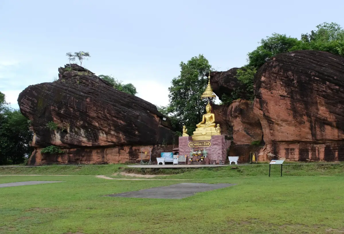
Three Whale Rock is the most famous landmark at Phu Sing. Located on the eastern side of the mountain, it consists of three enormous sandstone formations projecting above the forest. Their long, rounded shapes resemble Father Whale, Mother Whale, and Baby Whale traveling together. The distinctive forms developed naturally as less resistant material weathered and eroded, leaving more durable sandstone masses exposed. No human carving or deliberate arrangement was involved in creating the whale-like appearance.
The complete shape of Three Whale Rock is most recognizable from an elevated or aerial perspective, where the three formations can be seen together against the forest canopy. From above, they resemble marine animals moving through a sea of trees. Standing on the accessible rock surfaces offers a different experience, emphasizing the scale of the sandstone and the extensive panorama beyond the cliff. These contrasting viewpoints help explain why the attraction is so popular among travelers and landscape photographers.
The sandstone at Three Whale Rock is commonly described as being approximately 75 million years old. This estimate refers to the geological material rather than the age of the present whale-shaped contours. The recognizable formations developed through later cracking, erosion, and weathering. Their appearance demonstrates how sedimentary rocks originally formed in ancient environments can gradually evolve into distinctive landforms that people interpret and name according to familiar shapes.
Three Whale Rock is also an outstanding sunrise viewpoint. In the early morning, sunlight gradually spreads across the forested slopes and reveals the details of distant terrain. The color of the sandstone changes with the angle of the light, creating attractive contrasts between illuminated and shaded sections. On clear days, the viewpoint offers extensive views toward nearby forests, lowlands, and mountains across the border in Laos. The peaceful atmosphere of dawn is one of the principal reasons travelers visit the mountain early in the day.
From Three Whale Rock, visitors can admire landscapes associated with Phu Wua forest, Huai Bang Bat, Kaeng Sadok, and the Mekong River. When visibility allows, the mountains around Pak Kading in the Lao People's Democratic Republic can also be seen in the distance. These views demonstrate the relationship between sandstone mountains, woodlands, lowland terrain, and the wider Mekong basin. The expansive panorama is one of the defining features of the Phu Sing experience.
Despite its popularity as a photography destination, Three Whale Rock requires particular attention to safety. The sandstone formations stand along a high cliff, and continuous guardrails are not provided across every section. Visitors must remain within designated viewing areas, avoid dangerous edges, and refrain from running or posing in unstable positions. Taking photographs from secure locations provides excellent results without creating unnecessary risks for visitors or those accompanying them.
Access to the individual whale-shaped formations varies according to safety restrictions. Some smaller or more exposed sections are not open for direct walking access. These limitations reduce the risk of falls and help protect vulnerable sandstone surfaces. Visitors can still appreciate the overall formation from approved viewpoints and photograph the distinctive landscape without crossing barriers or attempting to reach restricted areas.
Hermit Cave Viewpoint, known locally as Tham Rue Si Viewpoint, is another important attraction on the eastern side of Phu Sing. It features large sandstone formations along a high cliff and offers views toward Phu Wua, Phu Thok Yai, Kaeng Sadok, the Mekong River's sandy areas, and the mountains near Pak Kading in Laos under favorable conditions. According to local tradition, the name is associated with a hermit who once practiced spiritual discipline in the area. This connection between landscape and folklore adds cultural significance to the viewpoint.
Tham Yai, or Big Cave, is another major natural site on the eastern side of Phu Sing. Its importance extends beyond geology because the cave is associated with the area's modern history. During the period from 1973 to 1980, corresponding to Buddhist Era 2516–2523, it was used as a shelter and resting place by communist insurgents during conflict with the Thai government. The forested mountain environment provided cover and protection, giving the area strategic importance. Tham Yai therefore represents both a natural sandstone formation and a place connected with historical events.
The Phu Sing Battlefield area contains traces of this period, including bunker-like depressions, shelters, and positions associated with the former conflict. These remains reveal another dimension of the mountain's history. The rugged terrain and dense forest made Phu Sing suitable for concealment and movement during the confrontation between government forces and communist insurgents. Exploring this historical context allows visitors to understand the mountain as more than a scenic attraction.
The history of the Phu Sing Battlefield is connected with the wider political and social conflicts that affected Thailand during the Cold War. Ideological struggles and the activities of the Communist Party of Thailand influenced various rural and forested regions, including parts of northeastern Thailand. Mountainous terrain played an important role in these events. The surviving traces at Phu Sing provide a local perspective on this period and contribute to the historical significance of the area.
Elephant Head Rock is located on the western side of Phu Sing. Viewed from a suitable distance, the large formation resembles the head of an elephant. Nearby rocks are arranged along the cliff in dramatic patterns, with some scenery resembling a broad canyon landscape. The viewpoint also overlooks areas of rubber plantations in Mueang Bueng Kan and Si Wilai districts. Its attraction lies in the combination of animal-shaped sandstone and views across the agricultural and forested terrain below.
The name Elephant Head Rock reflects a common tradition of naming natural formations after recognizable objects or animals. Such names help visitors identify and remember unusual landscapes. Comparing Elephant Head Rock with Three Whale Rock demonstrates how sandstone formations shaped by natural processes can develop very different appearances depending on their original structure, fractures, and exposure to erosion.
Elephant Rock is another formation with a shape resembling part of an elephant. It is situated near a steep cliff on the western side of the Phu Sing access route. Bamboo grows around parts of the formation, and visitors can look toward rubber plantations across nearby districts. The combination of sandstone and vegetation creates a distinctive environment and illustrates how plant life occupies spaces between large rock formations.
Train Rock is a substantial sandstone formation whose outline resembles the front of a railway train. Located toward the northern side of Phu Sing, it requires a longer walk than some of the more easily reached viewpoints. The area includes unusual rocks and natural water features. From permitted elevated positions, visitors can observe landscapes on both the eastern and western sides of the mountain. This makes Train Rock interesting both for its distinctive shape and its broader geographical perspective.
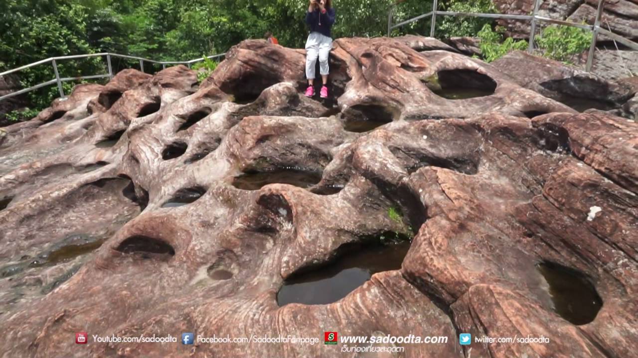
Sang Roi Bo is one of the most remarkable geological attractions on the western side of Phu Sing. Its exposed sandstone platform contains numerous natural depressions ranging from small hollows to larger basins. The local name refers to the many wells or holes visible across the rock surface. These formations have developed through erosion and weathering, creating an unusual landscape whose surface patterns differ considerably from the smooth, elongated masses of Three Whale Rock.
Water is an important factor in the development of the hollows at Sang Roi Bo. Rainwater can flow across the rock or collect in shallow depressions, encouraging further weathering in weaker sections. Over extended periods, some hollows become larger or deeper than others. During the rainy season, water may remain in parts of the basins, making the rock platform appear different from its dry-season condition. The site provides a striking example of how natural water processes can transform exposed sandstone.
Sang Roi Bo is also recognized as an excellent sunset viewpoint. The rock platform overlooks the western landscape, with forest and lowland scenery stretching into the distance. As the sun descends, the changing light produces a different atmosphere from the sunrise viewpoints on the eastern side of Phu Sing. The ability to experience morning and evening scenery from separate parts of the same mountain is one of the destination's most distinctive characteristics.
Phu Sing Stone Wall is another unusual formation, consisting of substantial sandstone surfaces arranged in a manner resembling a high natural wall. Wind, rainfall, and the structural arrangement of sandstone layers have contributed to its appearance. The exposed rock displays different patterns and contours, illustrating how erosion can transform natural geological structures into shapes that resemble human-made architecture.
Lan Hin Lai, or the Patterned Rock Platform, is an exposed sandstone area containing numerous small hollows and naturally developed surface patterns. Grass grows across some sections and changes in appearance with the seasons. During wetter periods, vegetation becomes green and more prominent, while dry conditions reduce its density. These seasonal changes demonstrate how moisture and limited soil accumulation influence plant growth on sandstone platforms.
Lan Tham Phu Sing is another area associated with sandstone platforms and scenic surroundings. Its relatively open landscape allows visitors to appreciate the mountain's rock formations from a different perspective. The name also evokes associations with calmness and contemplation, reflecting how natural environments can become places for quiet observation and reflection.
Pha Nam Thip Viewpoint is another recognized natural attraction at Phu Sing. Its position near elevated rock terrain provides views across the surrounding landscape. Because the mountain's viewpoints face different directions, each one reveals different aspects of the forests, slopes, and lowland areas. Visiting several viewpoints offers a broader understanding of Phu Sing's varied topography.
Phu Sing Gate and Heaven's Gate are names associated with natural openings between substantial sandstone formations. Their shapes resemble entrances formed by large rock masses. Such openings can develop where fractures and erosion gradually separate or remove sections of rock. These features demonstrate how sandstone can form recognizable shapes resembling structures without being carved or arranged by people.
Phu Sing also contains places connected with Buddhist devotion. A Buddha image known as Luang Pho Phra Sing is enshrined near a rock shelter. The connection between mountain landscapes and spiritual practice is found throughout Thailand, where forests and rocky hills have often provided peaceful settings for worship and meditation. Visitors should approach these religious areas respectfully and recognize their significance to local people and Buddhist devotees.
Touring Phu Sing differs from visiting an ordinary roadside viewpoint or public park. Parts of the mountain access road are narrow, steep, or unpaved, and organized sightseeing vehicles are used to carry visitors to the main natural attractions. These vehicles make it easier to reach locations distributed across the mountain and reduce the risks associated with driving unsuitable passenger cars on difficult terrain. The transport arrangements are an important element of safe and orderly tourism management.
A visitor service area and toilets are located near the entrance to the mountain route. This is the principal location for contacting personnel and completing the necessary arrangements before continuing uphill. Travelers arriving by private vehicle use the designated sightseeing transport system to reach the main viewpoints. Those planning to watch sunrise should arrive early enough to allow for the mountain transfer and the final walk to the observation areas.
The published sightseeing transport charge is 500 baht per vehicle, including the guided sightseeing arrangement associated with the service. This is a vehicle-based fee rather than a per-person admission charge. The transport system is convenient for groups and visitors unfamiliar with the mountain route. It also supports local service providers and contributes to the relationship between tourism and the economy of communities surrounding Phu Sing.
Overnight accommodation within the protected forest is subject to different restrictions from those applying to ordinary holiday parks. Published tourism information identifies the visitor service area and toilets near the entrance but does not list visitor cottages there. Camping inside the forest requires direct authorization from the responsible authorities. Visitors should not independently establish campsites or stay overnight in unauthorized locations. Accommodation in nearby communities or Bueng Kan town provides a practical alternative for those wishing to return to Phu Sing early the following morning.
Proper footwear is important when exploring Phu Sing because some attractions require walking across exposed sandstone, uneven ground, or sloping natural surfaces. Shoes with secure fastening and good traction are preferable to sandals. Comfortable clothing, drinking water, and protection from the sun are also useful, particularly for visitors who plan to explore several viewpoints during the same day.
During the rainy season, Phu Sing becomes lush and green as the forest receives abundant moisture. Clouds and mist may sometimes soften the appearance of distant hills, creating atmospheric scenery. However, wet sandstone and earthen paths can become slippery, and access to some areas may be affected by weather conditions. Visitors should follow staff instructions and avoid exposed sections when conditions make them unsafe.
Cooler and relatively dry weather is particularly comfortable for early morning viewpoints and short walks across the rock platforms. However, elevated cliffs may experience strong winds and conditions that differ from those in Bueng Kan town. Light outerwear can be helpful during early departures. During hotter periods, travelers should plan for stronger sunlight, limited shade on exposed sandstone, and an increased need for drinking water.
Phu Sing is suitable for many family travelers interested in natural scenery, although the accessibility of individual viewpoints depends on the abilities of each visitor. Young children require close supervision around cliffs and sloping rock surfaces. Older visitors and those with limited mobility should select walking distances and viewing locations appropriate to their condition. It is not necessary to reach every exposed formation to appreciate the mountain's landscape.
Photography is one of the most popular activities at Phu Sing. The variety of viewpoints and sandstone formations creates opportunities for landscape images throughout the day. Early morning light highlights the eastern ridges, while evening sunlight changes the appearance of western cliffs and rock platforms. Close observation of natural grooves and surface patterns also produces interesting compositions. Photographs should be taken only from permitted and stable locations without climbing on restricted rocks.
Drone photography within Phu Sing must comply with the requirements of the responsible authorities and applicable unmanned aircraft regulations. Unauthorized flights near visitors, wildlife, or exposed cliffs can create safety and environmental concerns. Ordinary ground-level photography from designated viewpoints remains an excellent way to record the mountain's geological scenery without disturbing the forest or other travelers.
Responsible tourism is essential for preserving the natural environment of Phu Sing. Visitors should not scratch, carve, paint, or leave marks on sandstone formations. Rocks, plants, and other natural materials should remain undisturbed. Litter must be disposed of appropriately rather than left on trails or between boulders. Maintaining a quiet atmosphere also contributes to the enjoyment of other visitors and helps reduce unnecessary disturbance to wildlife.
Safety must remain a priority throughout a visit because Phu Sing includes high cliffs, sloping rock platforms, and locations some distance from visitor facilities. Travelers should remain together on designated routes and avoid entering restricted forest areas. Instructions from local personnel are especially important during heavy rain, strong winds, or other conditions that increase the risk of accidents on exposed terrain.
Phu Sing is well suited to educational visits by students and anyone interested in geology or geography. Its sandstone layers, fractures, weathered surfaces, natural hollows, and unusual rock formations provide opportunities to observe geological processes directly. The landscape demonstrates that the features visible today are the result of changes occurring over long periods rather than sudden events. The site also offers lessons in forest conservation and the management of visitors within protected natural areas.
The diversity of Phu Sing's attractions makes it possible to study several geological features within a single area. Three Whale Rock illustrates the formation of substantial exposed sandstone masses. Sang Roi Bo demonstrates hollows associated with weathering and water, while Phu Sing Stone Wall reveals linear rock structures resembling architecture. Scenic viewpoints provide a wider geographical perspective on the relationship between mountains, forests, and nearby lowlands. These attractions are interconnected examples of the natural processes shaping the landscape.
Phu Sing is also important to the tourism identity of Bueng Kan Province. The recognizable whale-shaped rocks have attracted widespread interest through travel photography and visitor experiences. However, exploring the wider mountain reveals additional places of geological, historical, and cultural significance. Understanding Phu Sing as an extensive natural destination rather than simply the location of Three Whale Rock allows visitors to appreciate the full diversity of its attractions.
After visiting Phu Sing, travelers can continue to other destinations in Bueng Kan. Phu Thok in Si Wilai District is particularly notable for its sandstone mountain and wooden walkways along the cliff. The site is closely connected with Luang Pu Juan Kulachettho, a respected monk in Thailand's forest meditation tradition. A journey combining Phu Sing and Phu Thok offers contrasting experiences of natural geology and a mountain landscape associated with Buddhist religious practice.
Wat Ahong Silawat is another important Buddhist destination in Bueng Kan. Located near the Mekong River, it is associated with regional religious traditions and local stories connected with the river. Traveling from Phu Sing to the temple provides a contrast between forested mountains and a peaceful riverside religious environment. This combination is particularly attractive to visitors interested in both natural scenery and local cultural heritage.
Phu Wua Wildlife Sanctuary is another significant natural destination in Bueng Kan Province. Its forests, mountains, and waterfalls offer a different experience from Phu Sing's exposed sandstone cliffs. Chet Si Waterfall and Tham Phra Waterfall are among the well-known attractions associated with the broader Phu Wua landscape. Travelers planning a multi-day itinerary can combine mountain viewpoints and waterfall environments to experience a wider range of natural scenery in the province.
Bueng Kan town and the Mekong riverside are also suitable destinations after exploring Phu Sing. The urban riverside environment provides views of the river and neighboring Laos, along with restaurants and local communities. Traveling from elevated sandstone cliffs to the banks of the Mekong demonstrates the contrast between the province's mountainous interior and its riverside settlements.
Regional food adds another dimension to the experience of visiting Bueng Kan. The province shares the culinary traditions of northeastern Thailand and Mekong River communities. Visitors can enjoy dishes such as som tam, laab, spicy soups, and traditional local meals at restaurants in town and surrounding areas. Dining after a nature excursion provides time to rest while experiencing the flavors and everyday culture of the region.
Travelers who wish to watch sunrise at Phu Sing may find it convenient to stay overnight in Mueang Bueng Kan District or near Khok Kong Subdistrict. Staying nearby reduces the need for a lengthy drive before dawn. Accommodation in Bueng Kan town is suitable for visitors who also wish to explore the Mekong riverside or enjoy local restaurants in the evening, while rural properties closer to Phu Sing provide a quieter environment.
Phu Sing can be incorporated into a longer Bueng Kan itinerary together with Three Whale Rock, Phu Thok, Naka Cave, and waterfalls around Phu Wua. These attractions are not all close to one another and require different amounts of time and physical effort. Phu Sing primarily uses organized sightseeing transport, Phu Thok features mountain walkways, and Naka Cave requires a demanding uphill forest trek under national park regulations. Planning these visits across several days provides a more comfortable and rewarding travel experience.
The value of Phu Sing to Bueng Kan extends beyond visitor numbers. The destination encourages greater understanding of the relationship between geological formations, forests, and local communities. Seeing the landscape in person helps visitors appreciate why natural resource protection is essential to sustainable tourism. Appropriate use of local services, respect for regulations, and responsible behavior contribute to the benefits tourism can bring without compromising the environment.
Long-term conservation of Phu Sing requires protection of both its sandstone features and the surrounding forest. Geological formations develop over immense periods, yet damage caused by inappropriate human behavior can occur quickly. Leaving designated paths, carving on rocks, littering, or disturbing wildlife reduces the quality of the environment. Responsible tourism helps ensure that Phu Sing remains a valuable place for education, recreation, and nature appreciation.
Getting There: Phu Sing can be reached by private car or rental vehicle from Bueng Kan town. Travel along Highway 212, which connects Bueng Kan with Nakhon Phanom, before turning onto local roads toward Khok Kong Subdistrict and the Phu Sing visitor service area. Travelers arriving from other provinces can first reach Mueang Bueng Kan and continue to the mountain entrance. Upon arrival, visitors follow local registration and transport arrangements and use designated sightseeing vehicles to reach the natural attractions on the mountain.
Allow sufficient time for transfers between the attractions and for walking from vehicle stops to individual viewpoints. An early arrival is particularly important for sunrise visits, while travelers intending to explore several locations should generally allow around half a day, depending on the available routes and operating arrangements. Visitors must follow opening hours and staff instructions, especially around high cliffs and wet sandstone surfaces.
Phu Sing represents the remarkable natural heritage of Bueng Kan through its varied sandstone formations and extensive forest scenery. From the whale-shaped rocks and the distinctive hollows of Sang Roi Bo to enormous stone walls, caves, and historical sites, the mountain offers an unusually diverse collection of natural and cultural attractions. A visit provides opportunities to appreciate scenic landscapes, understand geological processes, explore traces of local history, and recognize the close relationship between forests and surrounding communities. Phu Sing is therefore much more than a beautiful viewpoint; it is an important natural learning destination and a valuable part of northeastern Thailand's environmental heritage.
| Name | Phu Sing, Bueng Kan Province |
| Location | Ban Khok Kong, Khok Kong Subdistrict, Mueang Bueng Kan District, Bueng Kan Province 38000, Thailand |
| Area Covered | Parts of Mueang Bueng Kan and Si Wilai districts |
| Area Type | Conservation area within national reserved forests |
| Forest Reserve | Dong Dip Kala, Phu Sing, and Dong Si Chomphu National Reserved Forest area |
| Area Size | Approximately 12,000 rai (1,920 hectares) |
| Landscape | Sandstone mountains, cliffs, caves, rock platforms, natural openings, and unusual rock formations |
| Highlights | Sunrise and sunset viewpoints on the same mountain, Three Whale Rock, and sandstone geological attractions |
| Historical Significance | Tham Yai and traces of the Phu Sing Battlefield associated with historical conflict between 1973 and 1980 |
| Responsible Authority | Royal Forest Department authorities responsible for the Phu Sing National Reserved Forest area |
| Open Days | Daily during designated visitor operations |
| Opening Hours | 05:00 – 17:00 |
| Sightseeing Transport Fee | 500 baht per vehicle, including the designated sightseeing service |
| Getting Around | Designated sightseeing vehicles from the visitor service area near the mountain entrance |
| Main Attractions And Zones | Three Whale Rock, Hermit Cave Viewpoint, Tham Yai, Phu Sing Battlefield, Elephant Head Rock, Elephant Rock, Train Rock, Sang Roi Bo, Phu Sing Stone Wall, Patterned Rock Platform, Lan Tham, and Pha Nam Thip Viewpoint |
| Religious Landmark | Luang Pho Phra Sing Buddha image near a rock shelter |
| Facilities | Visitor service area, toilets near the entrance, and sightseeing transport |
| Overnight Stays | No visitor cottages are listed at the mountain entrance. Camping within the protected forest requires authorization from the responsible authorities. |
| Best Visiting Time | Early morning for sunrise, and late afternoon for sunset at designated viewpoints |
| Safety Considerations | High cliffs, sloping rock surfaces, slippery paths after rain, and restricted access to some areas |
| Travel Information | Follow Highway 212 from Bueng Kan town, then take local roads toward Khok Kong Subdistrict and the Phu Sing visitor service area |
| Contact Numbers | +66 88 536 2717, +66 88 563 8852 |
| Attractions Within Phu Sing And Connected Areas | 1. Three Whale Rock – approximately 0.3 km from the Phu Sing map reference point 2. Hermit Cave Viewpoint – within Phu Sing 3. Sang Roi Bo – within Phu Sing 4. Elephant Head Rock – within Phu Sing 5. Elephant Rock – within Phu Sing 6. Train Rock – within Phu Sing 7. Phu Sing Stone Wall – within Phu Sing 8. Lan Tham Phu Sing – within Phu Sing |
| Restaurants And Cafes In Connected Areas | 1. Phu Cafe – Khok Kong Subdistrict, Tel. +66 95 946 6284 2. Sapparot – approximately 3.4 km from Three Whale Rock 3. Lab Ped Klang Thung – approximately 14 km from Three Whale Rock 4. Krua Yai Somjit – approximately 15 km from Three Whale Rock 5. Krua Mae Waen – approximately 16 km from Three Whale Rock 6. Je Ouan Pochana – approximately 21 km from Three Whale Rock |
| Accommodation In Connected Areas | 1. Ruen Rattana Resort – approximately 33.80 km from the Phu Sing route reference point 2. The One Hotel Bueng Kan – approximately 34.00 km from the Phu Sing route reference point, Tel. +66 42 492 234 3. BK Place Hotel – approximately 34.56 km from the Phu Sing route reference point 4. Saenghounghuaeng Motel 2 – approximately 35.82 km from the Phu Sing route reference point |
Frequently Asked Questions (FAQ)
Q: Where is Phu Sing located?
A: Phu Sing is located in the Dong Dip Kala, Phu Sing, and Dong Si Chomphu National Reserved Forest area around Khok Kong Subdistrict, Mueang Bueng Kan District, Bueng Kan Province, Thailand. The natural area extends across parts of Mueang Bueng Kan and Si Wilai districts.
Q: What are the opening days and hours of Phu Sing?
A: Published visitor information lists daily operations from 05:00 to 17:00. Access to individual attractions depends on designated routes, weather conditions, and local safety management.
Q: How much does it cost to visit Phu Sing?
A: The published sightseeing vehicle fee is 500 baht per vehicle, including the designated sightseeing service. This is a vehicle-based transport charge rather than an individual admission fee.
Q: What are the main attractions at Phu Sing?
A: Major attractions include Three Whale Rock, Hermit Cave Viewpoint, Tham Yai, the Phu Sing Battlefield, Elephant Head Rock, Elephant Rock, Train Rock, Sang Roi Bo, Phu Sing Stone Wall, Patterned Rock Platform, Lan Tham, and Pha Nam Thip Viewpoint.
Q: Can visitors watch both sunrise and sunset at Phu Sing?
A: Yes. Phu Sing has viewpoints facing both east and west. Three Whale Rock and Hermit Cave Viewpoint are associated with sunrise scenery, while Sang Roi Bo is well known for its sunset views.
Q: Is camping allowed at Phu Sing?
A: Phu Sing is a protected forest area managed by forestry authorities. Camping or staying overnight requires direct authorization from the responsible personnel, and visitors cannot independently establish campsites within the forest.
Q: Is Three Whale Rock part of Phu Sing?
A: Yes. Three Whale Rock is located within Phu Sing and is the area's most famous landmark. Its three enormous sandstone formations resemble a family of whales and offer panoramic forest views.
Q: What should travelers prepare before visiting Phu Sing?
A: Wear secure shoes with good grip, carry drinking water and sun protection, use the designated sightseeing transport service, and follow instructions from local personnel. Extra caution is necessary around high cliffs and wet sandstone surfaces.
 Category: ●Nature and Wildlife
 Group: ●Mountain (Doi)
Last Update : 2 WeekAgo
 Last Update : 2 WeekAgo
 Click to Access the Navigation Map GPS

 Art, Culture and Heritage
 Landmarks and Memorials(1)
 Museums(1)
 Places of Worship
 Temple(12)
 Other Sacred Sites(4)
 Suburban Living
 Local Market(1)
 National Parks and Marine Reserves(1)
Mountain (Doi)(3)
 Waterfalls(5)
 Caves(1)
 River, Canal(4)
 Bays and Beaches(1)
 Islands(1)
 Entertainment and Agricultural
 Waterpark(1)
 Shopping
 Shopping and Night Market(1)
 Travel Articles, Recipes
 Travel Review, Food Review(1)


