
lovethailand home >South Travel Attractions >Ranong Travel Attractions >Ka Poe >Muang Kluang > Ko Kam Tok (Ko Ao Khao Khwai)
TL;DR: Ko Kam Tok (Ko Ao Khao Khwai) is located at Mu Ko Kam, Laem Son National Park, Ranong Province, open Open for marine travel seasonally from 15 October to 15 May, and closed for, hours Laem Son National Park headquarters 08.30 – 16.30; visits to Ko Kam Tok are.
Ko Kam Tok (Ko Ao Khao Khwai)
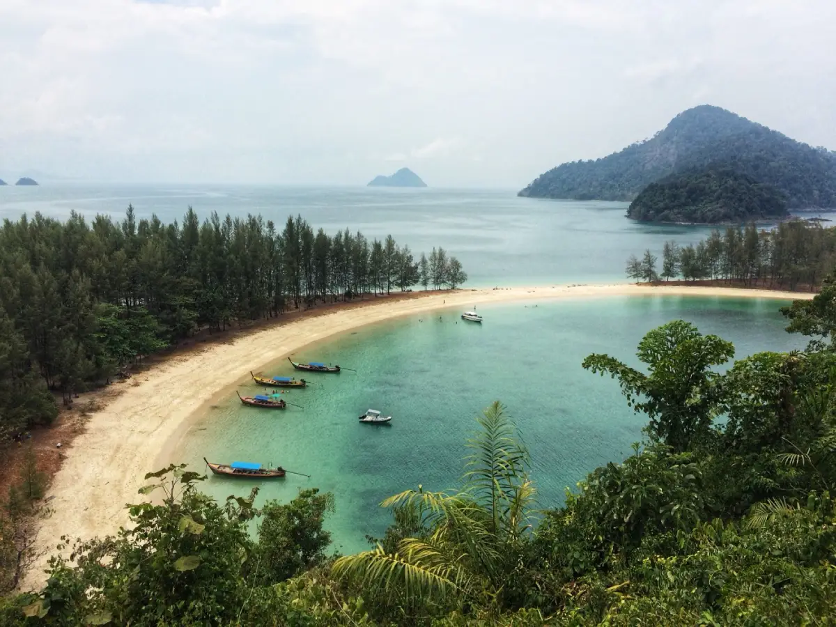
Open Days: Open for marine travel seasonally from 15 October to 15 May, and closed for natural recovery from 16 May to 14 October
Opening Hours: Laem Son National Park headquarters 08.30 – 16.30; visits to Ko Kam Tok are daytime boat trips subject to ranger instructions, sea conditions, and licensed boat operations
Ko Kam Tok, also known as Ko Ao Khao Khwai, is one of the most beautiful islands in Mu Ko Kam within Laem Son National Park, Ranong Province. Its main highlight is Ao Khao Khwai, a striking curved bay shaped like buffalo horns, with white sand, clear water, a hill viewpoint, a ranger station, and a quiet natural atmosphere. The island is best visited as a seasonal day trip by boat from the Bang Ben Beach area.
Ko Kam Tok, or Ko Ao Khao Khwai, is one of Ranong’s most distinctive marine attractions and a key island within Mu Ko Kam, a group of islands protected by Laem Son National Park. Located in the Andaman Sea off the coast of Ranong, the island is known for Ao Khao Khwai, a beautifully curved bay whose shape resembles buffalo horns when viewed from above. This natural bay, with white sand, clear blue water, and a green coastal backdrop, has become one of the signature seascapes of Ranong’s northern Andaman coast.
The charm of Ko Kam Tok does not come from luxury facilities or commercial beach development. It comes from simplicity. There are no permanent communities, no hotels, no rows of restaurants, and no nightlife on the island. What visitors find instead are a quiet beach, a natural bay, coastal trees, a viewpoint trail, the sound of waves, and the presence of national park rangers who manage the area for conservation and visitor safety. This makes the island ideal for travelers who want a raw, peaceful, and nature-focused marine experience.
Ao Khao Khwai is the heart of Ko Kam Tok. The bay curves into a wide natural arc, with white sand and clear water during the open marine season. From the beach, visitors can enjoy swimming in safe areas, walking along the shore, sitting under coastal trees, and photographing the distinctive line of sand and sea. From the viewpoint above the bay, the shape becomes clearer: the shoreline bends into a unique formation that explains why local people call the bay Ao Khao Khwai.
The name Ao Khao Khwai means Buffalo Horn Bay in Thai. The name comes from the curved sandbar and shoreline, which appear similar to buffalo horns when seen from a high angle. Standing on the beach gives only part of the impression, but the viewpoint reveals the bay’s full form. This elevated view is one of the main reasons travelers include Ko Kam Tok in a Mu Ko Kam boat trip.
Ko Kam Tok belongs to Mu Ko Kam, a cluster of islands within Laem Son National Park. Important islands in this group include Ko Kam Yai, Ko Kam Nui, Ko Kam Klang or Ko Yi Pun, Ko Kam Tok, Ko Khang Khao, Ko Lan, and Ko Kam Nui. Ko Kam Yai is often described as the central island of the group, while Ko Kam Tok is especially known for Ao Khao Khwai and the ranger unit located on the island. Many boat trips combine Ko Kam Tok with Ko Khang Khao and Ko Yi Pun in a single day.
The sea around Mu Ko Kam is mostly shallow compared with open offshore waters. Several areas are suitable for swimming, snorkeling, and beach stops when the sea is calm. Ko Khang Khao lies in deeper water than many of the nearby islands, which is why many local boat programs use it as part of a route that includes snorkeling, white beaches, and the viewpoint at Ao Khao Khwai. This combination gives travelers a fuller picture of Ranong’s marine landscape.
From Bang Ben Beach, one of the main visitor areas of Laem Son National Park, travelers can see islands scattered across the Andaman horizon on clear days. The view helps explain why this part of Ranong is more than a mainland coastal park. It is a marine landscape of beaches, mangroves, coastal forests, and island groups. Ko Kam Tok is one of the most memorable islands in that landscape because its bay has a strong visual identity and remains relatively undeveloped.
Most trips to Ko Kam Tok begin at Laem Son National Park near Bang Ben Beach or at a local pier used by authorized tour boats. Travelers usually drive from Ranong town toward Kapoe District, then continue to the Bang Ben Beach area. After paying national park fees and confirming weather and boat arrangements, visitors travel by local tour boat to the islands. A common route includes Ko Khang Khao first, then Ko Kam Tok, with the sea journey from Ko Khang Khao to Ko Kam Tok taking about 20 minutes depending on sea conditions.
Getting There is most practical by starting early from Ranong town. Travelers should drive or arrange transport to Laem Son National Park at Bang Ben Beach, allow time for park entry, boat coordination, safety briefing, and luggage preparation, then board a local boat for Mu Ko Kam. The mainland route uses Highway 4 toward Kapoe District before turning toward Bang Ben Beach. Before departure, visitors should confirm the sea condition, open-season status, return time, and the exact island route with the park or the boat operator.
Ko Kam Tok is best treated as a day-trip island. Overnight stays on the island are not the normal visitor model because the area is inside a national park and is managed primarily for conservation. Travelers who want to stay overnight should book accommodation at Laem Son National Park headquarters, near Bang Ben Beach, in Kapoe District, or in Ranong town, then take a boat trip during the day. This protects the island’s fragile environment and makes food, water, transport, and safety easier to manage.
The main activity on Ko Kam Tok is visiting Ao Khao Khwai and the viewpoint. The short climb to the viewpoint allows visitors to see the bay’s full curve, the white sand, the waterline, and the surrounding green landscape. The trail is natural, so visitors should wear suitable shoes and walk carefully, especially after rain. Staying on the designated path protects both travelers and the coastal vegetation.
Swimming should be done only in areas recommended by rangers or boat operators. Even when the bay looks calm, the Andaman Sea is affected by tides, wind, waves, and currents. Visitors who are not strong swimmers should wear life jackets. Children should remain close to adults, and nobody should swim far from the beach or beyond the area visible to the boat crew.
Snorkeling around Mu Ko Kam is popular because the area has coral, fish, and shallow marine habitats. Visitors should not stand on coral, touch marine life, feed fish, collect shells, or remove any natural objects from the park. Reef-safe sunscreen, careful fin use, and respectful behavior in the water help preserve the underwater environment that makes this part of Ranong special.
The trees along the beach are also part of the island’s appeal. Casuarina, sea almond, and other coastal plants create shade, stabilize the sand, reduce erosion, and support the coastal ecosystem. Sitting under the trees after swimming or hiking is one of the quiet pleasures of Ko Kam Tok, but visitors should avoid damaging roots, breaking branches, or tying objects to trees without permission.
There are no regular restaurants on Ko Kam Tok. Travelers should bring drinking water and a packed lunch, or order food from the Bang Ben Beach area before departure. All packaging, bottles, food scraps, and small waste should be carried back to the mainland. Even minor litter harms wildlife, spoils the scenery, and creates long-term problems for national park staff.
The best period to visit Ko Kam Tok is during the open marine season from 15 October to 15 May. The period from 16 May to 14 October is the annual closure period for natural recovery and safety during the monsoon season. Travelers should not attempt to enter closed marine areas and should always confirm the latest announcement with Laem Son National Park before planning a trip.
A good one-day route usually starts in the morning from Bang Ben Beach, visits Ko Khang Khao for beach scenery or snorkeling, continues to Ko Yi Pun or Ko Kam Klang, and then stops at Ko Kam Tok for Ao Khao Khwai and the viewpoint. Returning to the mainland in the afternoon keeps the trip safer and more comfortable. This route offers beaches, snorkeling, island scenery, and the bay viewpoint without rushing too much.
Ko Khang Khao is one of the most common companion stops on a Ko Kam Tok trip. It is known for white sand, clear water, and a distinctive pebble beach on one side. Ko Yi Pun, also known as Ko Kam Klang, is another nearby island often included in the route because of its pale sand and relaxed beach atmosphere. These nearby islands make Mu Ko Kam suitable for travelers who want a compact but varied marine day trip.
Travelers who enjoy quiet nature will understand Ko Kam Tok quickly. This is not a place for excessive comfort or entertainment. It is a place for white sand, clear water, a short viewpoint walk, calm beach time, and direct contact with Ranong’s Andaman landscape. Visitors who arrive with the right expectations will find the island more rewarding than a commercial beach because its beauty feels unforced and uncluttered.
Boat prices and departure times should be checked before travel. Older fare information should not be treated as final because prices depend on the operator, boat size, group size, season, route, and sea condition. During long weekends and the high season, advance contact is strongly recommended because suitable departure windows and boat availability are limited.
Useful items for a Ko Kam Tok trip include drinking water, lunch, a hat, sunglasses, sun-protective clothing, reef-safe sunscreen, waterproof phone pouch, towel, personal medication, comfortable beach shoes, and a personal trash bag. Travelers who get seasick should prepare accordingly before departure. The boat route may cross open water and can feel rough even on a generally clear day.
Responsible behavior is essential in a national park marine area. Visitors should follow ranger instructions, avoid loud noise, stay on marked trails, avoid damaging plants, avoid writing on rocks or trees, never take sand, shells, stones, coral, or marine life, and carry all waste back to the mainland. The more beautiful and fragile a place is, the more carefully it must be visited.
Compared with larger southern island destinations, Ko Kam Tok stands out because of its quiet atmosphere and distinctive bay shape. Travelers should not expect hotels, shops, or full facilities on the island. They should come for nature, simplicity, and a carefully managed marine day trip. With the right timing and responsible planning, Ko Kam Tok becomes one of the most memorable island experiences in Ranong.
In summary, Ko Kam Tok or Ko Ao Khao Khwai is a signature marine attraction of Laem Son National Park and Mu Ko Kam. Its curved bay, white sand, clear water, viewpoint, and peaceful setting make it ideal for a seasonal day trip from Bang Ben Beach. Travelers should visit during the open marine season, prepare food and water, use responsible boat services, follow national park rules, and help keep Ranong’s sea clean and naturally beautiful.
| Name | Ko Kam Tok / Ko Ao Khao Khwai |
| Location | Mu Ko Kam, Laem Son National Park, Ranong Province |
| Address | Ko Kam Tok, Laem Son National Park, Kapoe District, Ranong Province 85120, Thailand |
| Coordinates | Ao Khao Khwai 9.51385, 98.35504 / Ko Kam Tok 9.51667, 98.35000 |
| Highlights | Buffalo-horn-shaped bay, white sand, clear water, hill viewpoint, national park ranger unit, and a quiet natural atmosphere |
| History | Part of Laem Son National Park, which was declared a national park on 19 August 1983 and covers coastal and island areas in Ranong and Phang Nga. |
| Name Origin | Ao Khao Khwai means Buffalo Horn Bay, named after the curved shoreline and sandbar that resemble buffalo horns from above. |
| Distinctive Features | A natural national park island with no permanent village and no hotel on the island, suitable for seasonal day trips. |
| Travel Information | Travel from Ranong town to Laem Son National Park at Bang Ben Beach, then take a local tour boat to Mu Ko Kam. The boat trip from Ko Khang Khao to Ko Kam Tok takes about 20 minutes. |
| Current Status | A seasonal marine attraction within Laem Son National Park, open during the marine travel season and closed during the monsoon recovery period. |
| Open Days | Open for marine travel seasonally from 15 October to 15 May, and closed for natural recovery from 16 May to 14 October |
| Opening Hours | Laem Son National Park headquarters 08.30 – 16.30; visits to Ko Kam Tok are daytime boat trips subject to ranger instructions and boat operations. |
| Fees | Thai adult 40 baht, Thai child 20 baht / foreign adult 200 baht, foreign child 100 baht. Boat and other service fees are charged separately. |
| Facilities | Ranger unit, toilets in designated areas, beach resting areas, viewpoint trail, and national park staff support. No regular restaurant or accommodation on the island. |
| Main Areas / Zones | Ao Khao Khwai, curved white-sand beach, viewpoint, ranger unit, coastal trees, swimming area, and designated boat landing area |
| Caretaker / Related Authorities | Laem Son National Park, Department of National Parks, Wildlife and Plant Conservation |
| Main Contact Number | Laem Son National Park Tel. 077-861-431 |
| Official Website / Official Page | Laem Son National Park Facebook page and Department of National Parks information system |
| Nearby Tourist Attractions | 1. Ko Khang Khao, about 6 km by boat 2. Ko Yi Pun or Ko Kam Klang, about 2 km by boat 3. Ko Kam Yai, about 3 km by boat 4. Bang Ben Beach, about 16 km by boat 5. Laem Son Beach, about 18 km by boat 6. Praphat Beach, about 25 km by boat and road 7. Ko Phayam, about 19 km by boat |
| Nearby Restaurants | 1. Yadda Chim Kon Prung, about 1 km from the park headquarters, Tel. 085-796-2374, 081-788-7096 2. Krua Suksamran, about 30 km from the park headquarters, Tel. 077-893-186 3. OK Seafood, about 57 km from the park headquarters, Tel. 093-686-9595 4. Tho Fan Seafood, about 60 km from the park headquarters, Tel. 081-536-9885 5. Somyos Pak Nam Seafood, about 65 km from the park headquarters |
| Nearby Accommodations | 1. Laem Son National Park accommodation, about 0 km, Tel. 077-861-431 2. Andaman Peace Resort, about 2 km 3. Ranong Resort and Laguna, about 12 km 4. SS Kapoe Resort, about 14 km, Tel. 085-797-4746 5. Baan Rai I Arun, about 22 km, Tel. 096-938-2981 |
Frequently Asked Questions (FAQ)
Q: Where is Ko Kam Tok or Ko Ao Khao Khwai located?
A: Ko Kam Tok, also known as Ko Ao Khao Khwai, is located in Mu Ko Kam within Laem Son National Park, Ranong Province. It is usually visited by boat from the Bang Ben Beach area.
Q: When is Ko Kam Tok open for visitors?
A: Ko Kam Tok is open for marine travel seasonally from 15 October to 15 May and closed for natural recovery from 16 May to 14 October.
Q: Is there an entrance fee for Ko Kam Tok?
A: Yes. The Laem Son National Park entrance fee is 40 baht for Thai adults, 20 baht for Thai children, 200 baht for foreign adults, and 100 baht for foreign children. Boat fees are charged separately.
Q: How do travelers get to Ko Kam Tok?
A: Travelers go from Ranong town to Laem Son National Park at Bang Ben Beach, then take a local tour boat to Mu Ko Kam. The route is often combined with Ko Khang Khao and Ko Yi Pun.
Q: Are there hotels or restaurants on Ko Kam Tok?
A: No. Ko Kam Tok has no regular hotel or restaurant on the island. Visitors should plan a day trip and bring drinking water, lunch, and a personal trash bag.
Q: What can visitors do on Ko Kam Tok?
A: Visitors can walk on the beach, swim in safe areas, enjoy Ao Khao Khwai from the viewpoint, take nature photos, relax by the sea, and snorkel at suitable points recommended by rangers or boat operators.
Q: What should travelers bring to Ko Kam Tok?
A: Useful items include drinking water, lunch, a hat, sunglasses, reef-safe sunscreen, beach shoes, a waterproof phone pouch, personal medication, and a bag for carrying trash back to the mainland.
Q: Which nearby islands pair well with Ko Kam Tok?
A: Ko Khang Khao, Ko Yi Pun or Ko Kam Klang, Ko Kam Yai, and Bang Ben Beach are commonly combined with Ko Kam Tok in a one-day Mu Ko Kam boat trip.
 Category: ●Nature and Wildlife
 Group: ●Islands
Last Update : 2 MonthAgo
 Last Update : 2 MonthAgo
 Click to Access the Navigation Map GPS
Ko Kam Tok (Ko Ao Khao Khwai) Map
Recommend

 Art, Culture and Heritage
 Historical Sites and Monuments(4)
 Landmarks and Memorials(1)
 Royal Palace(1)
 Art, Craft Centres, Tradition(4)
 Educational Places
 Educational Gardens, Farm(1)
 Places of Worship
 Temple(12)
 Other Sacred Sites(2)
 Suburban Living
 Village, Community(2)
 National Parks and Marine Reserves(6)
 Mountain (Doi)(4)
 Waterfalls(15)
 Hot Springs(3)
 Caves(4)
 River, Canal(2)
 Bays and Beaches(10)
Islands(8)
 Other natural attractions(3)
 Travel Articles, Recipes
 Travel Review, Food Review(1)


