
lovethailand home >South Travel Attractions >Ranong Travel Attractions >Muang Ranong >Hat Som Paen > Ranong Canyon
TL;DR: Ranong Canyon is located at Ban Thung Kha, Hat Som Paen Subdistrict, Mueang Ranong District, Ranong Province 85000, open Daily, hours 09.00 – 16.00.
Ranong Canyon
Open Days: Daily
Opening Hours: 09.00 – 16.00
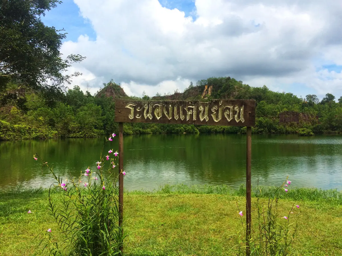
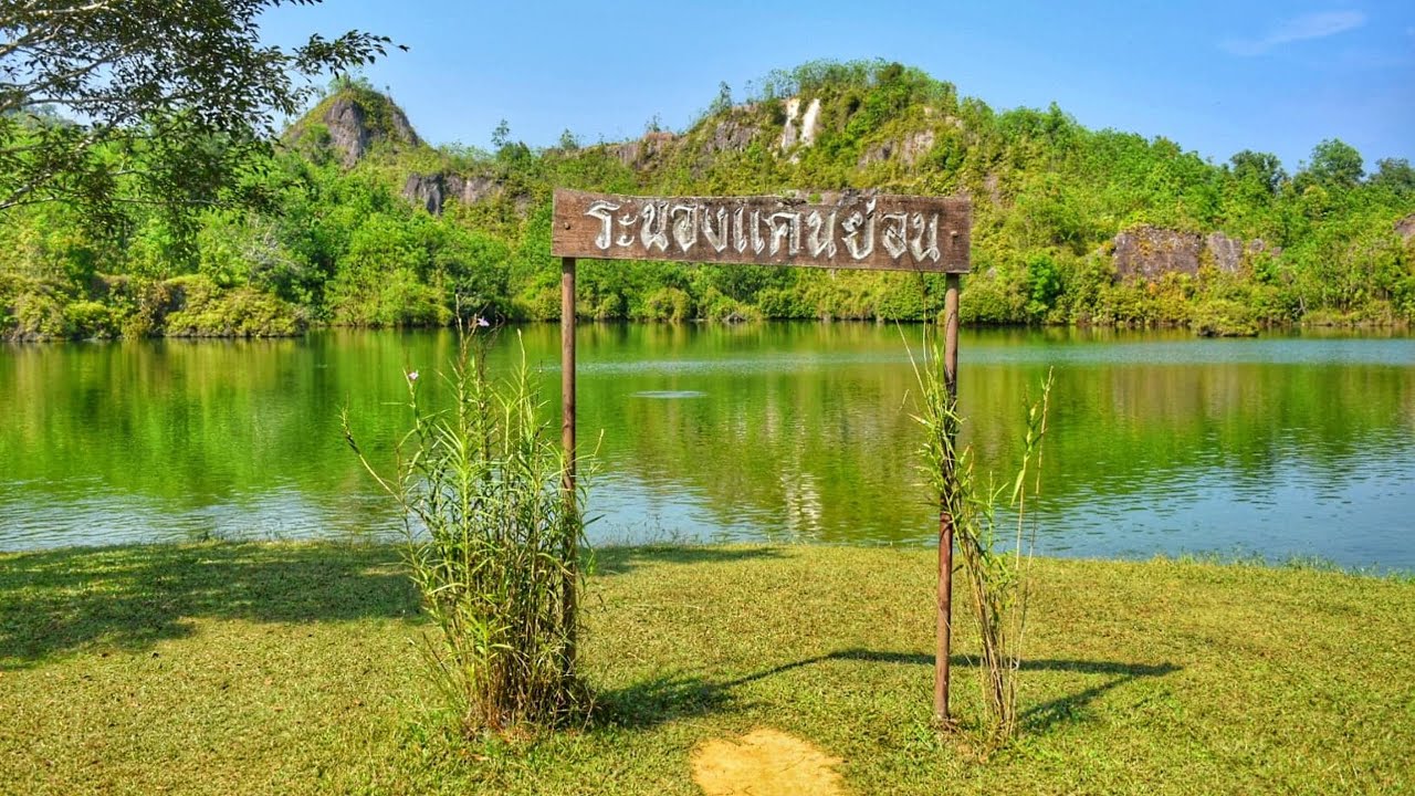
Ranong Canyon is a distinctive nature attraction in Hat Som Paen Subdistrict, Mueang Ranong District, Ranong Province. Located around Ban Thung Kha on the route from Ranong town toward Raksa Warin Hot Spring, Wat Hat Som Paen, and the Hat Som Paen community, the site is known for its large emerald-green pond surrounded by hills, pale rock faces, eroded earth cliffs, and lush vegetation. Its appeal is not only scenic. Ranong Canyon is a landscape shaped by the history of tin and kaolin mining in Hat Som Paen before the abandoned mining area gradually became a peaceful viewpoint, photo stop, fish-feeding area, and community nature attraction.
The site was formerly known as “Bueng Morakot,” or Emerald Pond. When viewed from the higher ground, the water reflects the sky and surrounding trees, creating a blue-green colour similar to emerald. On some mornings, light mist floats above the water as moisture rises from the trees and pond surface. This gives the place a cool, quiet, and almost hidden atmosphere. The name Ranong Canyon refers to the small canyon-like form of the landscape, where steep walls and a deep basin create a dramatic natural-looking scene, even though the landform began from former human activity and later recovered through natural processes.
Ranong Canyon was formed from an old mining area. In the past, high-pressure water was used to wash soil and separate minerals from earth and sand. Over time, this process eroded the land surface and created a deep basin. After mining stopped, the abandoned pit was surrounded by earth cliffs and rock walls. Natural springs and Ranong’s frequent rainfall then filled the basin, turning it into a large pond. What was once a mining scar has become one of the most unusual landscapes near Ranong town.
The most attractive feature of Ranong Canyon is the contrast between the still green water and the rugged cliffs around it. Trees grow along the edges of the basin, creating shade and a calm atmosphere suitable for sitting, feeding fish, taking photos, and enjoying the view. The best photo spots are around the pond, where visitors can frame the emerald water against the pale rocks and green hills. Morning and late afternoon are the best times for softer light, cooler weather, and a more relaxed atmosphere.
Ranong Canyon is located about 2.5–3 kilometres beyond Wat Hat Som Paen and roughly 12–15 kilometres from Ranong town. It is therefore ideal for a half-day route from the town centre. A practical itinerary can begin at Raksa Warin Hot Spring, continue to Wat Hat Som Paen, stop at Ranong Canyon, and then visit Khlong Hat Som Paen Reservoir or the Mineral Panning Wisdom Learning Centre. This route reveals several layers of Ranong: hot springs, local faith, old mining history, emerald water, mountain scenery, and the community heritage of mineral panning.
The pond at Ranong Canyon contains many fish, making fish feeding one of the most popular activities. Visitors often sit by the water and watch the fish gather near the edge. The site has the character of a community attraction, with basic facilities such as parking, toilets, small local shops, seating areas, and pavilions by the water. There is no entrance fee, so visitors can enjoy the view and rest without paying admission. Some optional activities, such as fish food, pedal boats, or kayaks, may have on-site service fees.
Although the water looks clear and inviting, Ranong Canyon is not a swimming site. The pond was formed from an old mining pit, and the water can be deep. Some edges are steep or slippery, especially during or after rain. Visitors should enjoy the view from safe areas, avoid climbing rock edges, avoid entering the water, and supervise children closely. Ranong is a rainy province, so wet ground and slippery surfaces should always be expected during the monsoon season.
Ranong Canyon is closely connected with the history of Hat Som Paen. This subdistrict has long been associated with tin, kaolin, mineral panning, and mining-related livelihoods. The community name is linked with the local history of Chinese miners and the area’s old mineral economy. Today, Hat Som Paen has developed a Mineral Panning Wisdom Learning Centre to preserve and present this heritage. For this reason, Ranong Canyon should not be seen only as a beautiful pond. It is also a visible remnant of the mining landscape that shaped the community.
Ban Hat Som Paen is known for its local identity, which includes Ranong Canyon, Wat Hat Som Paen, the sacred fish in Hat Som Paen Canal, kaolin ceramics, the mineral-panning learning centre, Khlong Hat Som Paen Reservoir, and community-based activities. A visit to Ranong Canyon can therefore be extended into a wider Hat Som Paen cultural route. This makes the experience more meaningful because visitors can see how nature, religion, local occupations, water resources, and mining history are connected within one mountain valley community.
Wat Hat Som Paen is one of the most important nearby places to combine with Ranong Canyon. It is a spiritual centre of the community and is associated with Luang Pho Klai, a respected monk of southern Thailand. The temple grounds include Hat Som Paen Canal, where large schools of fish live in the stream and visitors commonly feed them from riverside platforms. Many travelers visit the temple before or after Ranong Canyon because the two sites are close together and share the same local route.
Khlong Hat Som Paen Reservoir adds another natural element to the journey. The reservoir supports local agriculture and raw water supply for the area, while also offering mountain scenery and a quiet setting. When combined with Ranong Canyon, the reservoir helps visitors understand how water, hills, community life, and natural resources shape daily life in Hat Som Paen.
The Mineral Panning Wisdom Learning Centre is especially useful for visitors who want to understand why Ranong Canyon exists. The centre preserves tools, stories, and practical knowledge related to local tin panning and mining heritage. Visitors can learn about tin, kaolin, traditional panning techniques, and community culture. Seeing Ranong Canyon after visiting the centre allows travelers to connect the landscape with the lives and occupations that created it.
Raksa Warin Hot Spring is a suitable starting or ending point for a Ranong Canyon trip. It lies on the route between Ranong town and Hat Som Paen and is one of the best-known natural hot spring areas in the province. The area includes public relaxation spaces and mineral hot water features used by locals and visitors. A route that links Raksa Warin Hot Spring, Wat Hat Som Paen, Ranong Canyon, and Khlong Hat Som Paen Reservoir offers a compact but complete day trip near Ranong town.
The best time to visit Ranong Canyon is in the morning or late afternoon. The light is softer, the air is cooler, and the water often reflects the sky and trees more beautifully than at midday. Morning visitors may sometimes see a light mist above the pond. The site can be visited year-round, but during the rainy season visitors should allow for wet roads, slippery ground, and changing weather. On clear days, the emerald colour of the pond and the surrounding hills are especially photogenic.
Getting There is easiest by private car, rental car, motorcycle, or local hired vehicle. From Ranong town, follow the route toward Raksa Warin Hot Spring and continue along Highway 4005, the Ranong–Hat Som Paen road. Pass Wat Hat Som Paen, then continue uphill toward Ban Thung Kha for about 2.5 kilometres to reach Ranong Canyon. From the town centre, the journey usually takes about 20–30 minutes depending on traffic and weather.
Travelers without private transport can arrange a local songthaew, taxi, or hired vehicle from Ranong town. It is best to agree on the fare and return time in advance because public transport does not run frequently around the canyon area. For visitors planning to combine several places, such as Raksa Warin Hot Spring, Wat Hat Som Paen, Ranong Canyon, the reservoir, and the mineral-panning centre, a half-day hired vehicle is more convenient than arranging separate rides.
Ranong Canyon is suitable for families, casual travelers, photographers, students, nature lovers, and visitors interested in local mining history. Its strength is that it does not require a long trip, but it still explains Ranong well. The province is known for rain, mountains, hot springs, old mines, humid forests, and communities that have adapted to local resources over generations. Ranong Canyon brings many of these themes together in a single accessible place.
Visitors should avoid swimming, climbing steep rock edges, leaving rubbish, overfeeding fish, throwing packaging into the pond, or standing too close to slippery edges. During the rainy season, bring rain protection and wear shoes with good grip. The site is simple and community-based, so visitors should use the facilities respectfully and help keep the area clean.
Overall, Ranong Canyon is more than an emerald pond. It is a former mining landscape transformed into a peaceful community attraction. It brings together water, hills, old mining history, kaolin, local livelihoods, and the natural atmosphere of Hat Som Paen. For travelers staying in Ranong town, it is one of the easiest places to visit for a short but meaningful nature trip, especially when combined with Wat Hat Som Paen, Raksa Warin Hot Spring, and the mineral-panning learning route.
| Name | Ranong Canyon |
| Other Names | Ranong Canyon, Emerald Pond, Former Ranong Mining Pond |
| Place Type | Nature Attraction, Former Mining Landscape, Viewpoint, Photo Spot, And Hat Som Paen Community Learning Route |
| Location | Ban Thung Kha, Hat Som Paen Subdistrict, Mueang Ranong District, Ranong Province 85000 |
| Reference Coordinates | 9.935976, 98.685465 |
| Responsible Local Bodies | Hat Som Paen Subdistrict Administrative Organization And Ban Hat Som Paen Community-Based Tourism Group |
| Community Contact Number | Hat Som Paen Subdistrict Administrative Organization, Tel. 077-862-509 |
| Highlights | Emerald-Green Pond, Former Mining Cliffs, Mountain Setting, Fish Feeding Area, Riverside Pavilion, Photo Spots, And Hat Som Paen Community Route |
| History / Origin | The site developed from an old mining area where water was used to wash soil and separate minerals, leaving a deep basin that later filled with spring water and rainwater. |
| Landscape | A large pond in a former mining basin surrounded by earth cliffs, pale rocks, green hills, and humid vegetation typical of Ranong. |
| Recommended Activities | Viewpoint Photography, Relaxing By The Pond, Fish Feeding, On-Site Pedal Boat Or Kayak Activities, And Combining The Trip With Wat Hat Som Paen, The Reservoir, And The Mineral Panning Learning Centre |
| Main Zones | Emerald Pond Edge, Waterfront Pavilion, Fish Feeding Area, Parking Area, Community Shops, Toilets, And Viewpoints Around The Pond |
| Current Status | Open As A Community Nature Attraction And Resting Spot In Ban Hat Som Paen, Accessible Year-Round Depending On Weather Conditions |
| Open Days | Daily |
| Opening Hours | 09.00 – 16.00 |
| Admission Fee | No Admission Fee. Optional Activities And Fish Food Are Charged On Site. |
| Safety Notes | Swimming Is Not Recommended Because The Pond Was Formed From An Old Mining Pit With Deep Water And Some Steep Or Slippery Edges. |
| Facilities | Parking, Toilets, Waterfront Pavilion, Community Shops, Seating Areas, Fish Feeding Area, And Resting Points Around The Pond |
| Best Time To Visit | Morning And Late Afternoon, When The Light Is Softer, The Air Is Cooler, And Light Mist May Appear Above The Pond On Some Days |
| Travel Information | From Ranong town, follow the route to Raksa Warin Hot Spring and Highway 4005 toward Hat Som Paen. Pass Wat Hat Som Paen, then continue uphill toward Ban Thung Kha for about 2.5 km. The site is about 12–15 km from Ranong town. |
| Nearby Tourist Attractions | 1. Wat Hat Som Paen, about 2.5–3 km 2. Mineral Panning Wisdom Learning Centre, about 3 km, Tel. 090-424-8513 3. Khlong Hat Som Paen Reservoir, about 4–5 km 4. Raksa Warin Hot Spring, about 9–10 km 5. Rattanarangsan Palace And Ranong Old Town, about 12–14 km 6. Phu Khao Ya / Khao Hua Lan, about 22–25 km |
| Nearby Restaurants | 1. Chatbatt@Ranong, about 4 km, Tel. 095-260-3070 2. U Cafe’ At U Sabai Ranong Resort & Cafe, about 5 km, Tel. 077-810-337, 091-424-9191 3. Somtam Nai Fun, about 6 km, Tel. 083-555-1056 4. C’est Bien @ Baanchuengkao, about 10 km, Tel. 091-035-0978, 077-985-229 5. Kunlin Restaurant Ranong, about 10 km, Tel. 077-822-863 6. J & T Restaurant Ranong, about 13 km, Tel. 077-812-483 |
| Nearby Accommodations | 1. Ban Hat Som Paen Homestay, about 4–5 km, Tel. 093-624-5478 2. Baanhatsompaen Homestay, about 4.2 km, Tel. 082-339-6275 3. U Sabai Ranong Resort & Travel, about 5 km, Tel. 077-810-337, 091-424-9191 4. Baanchuengkao Resort, about 10 km, Tel. 077-826-900, 077-826-990, 077-985-229, 091-035-0978 5. The Galla Hotel, about 13 km, Tel. 077-880-898 6. Sook Hotel Ranong, about 13–14 km, Tel. 077-812-555-8, 093-581-2500 |
Frequently Asked Questions (FAQ)
Q: Where is Ranong Canyon located?
A: Ranong Canyon is located around Ban Thung Kha in Hat Som Paen Subdistrict, Mueang Ranong District, Ranong Province. It is close to Wat Hat Som Paen and about 12–15 km from Ranong town.
Q: What are the opening days and hours of Ranong Canyon?
A: Ranong Canyon is open daily from 09.00 to 16.00.
Q: Is there an admission fee for Ranong Canyon?
A: There is no admission fee. Visitors can relax, take photos, and enjoy the view for free, while optional activities and fish food are charged on site.
Q: How was Ranong Canyon formed?
A: Ranong Canyon was formed from an old mining area. Water used in mining washed away soil and created a deep basin, which later filled with spring water and rainwater to become an emerald pond.
Q: Can visitors swim at Ranong Canyon?
A: Swimming is not recommended because the pond was formed from an old mining pit, with deep water and some steep or slippery edges. It is better for sightseeing, photography, relaxing, and fish feeding.
Q: What is the best time to visit Ranong Canyon?
A: Morning and late afternoon are the best times because the weather is cooler, the light is better for photography, and light mist may appear above the pond on some mornings.
Q: What nearby places can be combined with Ranong Canyon?
A: Nearby places include Wat Hat Som Paen, the Mineral Panning Wisdom Learning Centre, Khlong Hat Som Paen Reservoir, and Raksa Warin Hot Spring. They are all suitable for a half-day route from Ranong town.
Q: How do travelers get to Ranong Canyon?
A: From Ranong town, follow the route to Raksa Warin Hot Spring and Highway 4005 toward Hat Som Paen. Pass Wat Hat Som Paen, then continue uphill toward Ban Thung Kha for about 2.5 km. Private car, rental car, motorcycle, or local hired transport is the most convenient option.
 Category: ●Nature and Wildlife
 Group: ●Mountain (Doi)
Last Update : 2 MonthAgo
 Last Update : 2 MonthAgo
 Click to Access the Navigation Map GPS
Ranong Canyon Map
Recommend

 Art, Culture and Heritage
 Historical Sites and Monuments(4)
 Landmarks and Memorials(1)
 Royal Palace(1)
 Art, Craft Centres, Tradition(4)
 Educational Places
 Educational Gardens, Farm(1)
 Places of Worship
 Temple(12)
 Other Sacred Sites(2)
 Suburban Living
 Village, Community(2)
 National Parks and Marine Reserves(6)
Mountain (Doi)(4)
 Waterfalls(15)
 Hot Springs(3)
 Caves(4)
 River, Canal(2)
 Bays and Beaches(10)
 Islands(8)
 Other natural attractions(3)
 Travel Articles, Recipes
 Travel Review, Food Review(1)


