
lovethailand home >South Travel Attractions >Ranong Travel Attractions >La Un >Bangk Kaeo > Khao Fa Chi
TL;DR: Khao Fa Chi is located at Ban Khao Fa Chi, Moo 4, Bang Kaeo Subdistrict, La-un District, Ranong Province 85130, open Daily, hours 05.00 – 18.00.
Khao Fa Chi
Open Days: Daily
Opening Hours: 05.00 – 18.00
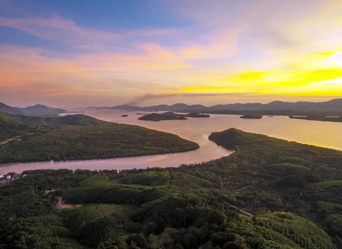
Khao Fa Chi, or Khao Fa Chi Viewpoint, is one of Ranong’s most distinctive mountain viewpoints. Located at Ban Khao Fa Chi, Moo 4, Bang Kaeo Subdistrict, La-un District, Ranong Province, it stands about 30 kilometres from Ranong town. The hill is about 259 metres above sea level and takes its name from its rounded shape, which resembles a traditional Thai food cover called a fa chi. From the summit, visitors can see the Kra Buri River meeting the La-un River before flowing toward the Andaman Sea. The view also includes mangrove forest, river islands, local riverside communities and the mountain line of Myanmar across the natural border.
The main value of Khao Fa Chi is that it presents Ranong’s border landscape in one clear panorama. This is not only a high viewpoint; it is a place where geography, history and local life can be read together. The Kra Buri River forms a natural boundary between Thailand and Myanmar, while the La-un River flows into it before the water opens toward the Andaman Sea. Depending on light, tide, mist and season, the view below can shift from a bright river-mouth panorama to a soft mist-covered landscape.
The best times to visit are early morning and late afternoon. Morning is ideal for mist, especially after rain or during the late rainy season to early cool season. Mist often floats above the water and mangrove landscape, creating a quiet and layered view. Late afternoon is best for sunset. As the sun drops, the water surface, islands, forest and mountain lines change colour, making Khao Fa Chi one of the most rewarding sunset viewpoints in Ranong. November to December is especially popular for clear evening light and cooler air.
Khao Fa Chi suits travelers who enjoy natural viewpoints, photographers, self-drive travelers, motorcyclists, families passing through the Ranong–Chumphon route and visitors interested in local history. A simple visit to the viewpoint usually takes 30 minutes to 1 hour. Travelers who want a fuller experience should combine the hill with Ban Khao Fa Chi community, the World War II historical museum, Khlong La-un and the Km 30 viewpoint below the hill.
The summit area is associated with the Khao Fa Chi telecommunications relay centre and an open viewing area. Visitors usually stop near the viewpoint sign, look down toward the rivers and wait for the light to change. On clear days, the river channels, islands, mangrove areas and Myanmar side are visible in detail. On misty days, the scenery becomes softer and more atmospheric, especially when clouds and fog drift above the water.
Khao Fa Chi is also historically important. During World War II, the Ban Khao Fa Chi area became a strategic site for the Japanese military because of its border location and its ability to connect land transport from the Gulf of Thailand side with water transport toward the Andaman side. The Japanese built the Kra Isthmus railway route from Chumphon to Khao Fa Chi to support wartime logistics. This turned the small border community into an important wartime corridor.
The Kra Isthmus railway is an important part of Ranong border history. Construction began during the World War II period, and Khao Fa Chi became the western terminus connected with river transport via Khlong La-un and the Kra Buri River. After the war, the railway was abandoned and dismantled in parts. Today, traces of this history remain through the steam locomotive, railway remains, local memory, tunnel stories and the World War II historical museum in Ban Khao Fa Chi.
The World War II historical museum at Ban Khao Fa Chi should be visited together with the viewpoint. It helps visitors understand why this hill is more than a scenic photo spot. The museum area displays a steam locomotive, rail remains and historical traces related to the Kra Isthmus railway. The Mikado steam locomotive No. 962 is one of the most notable objects in the museum area and helps visitors imagine the wartime movement of people, goods and military supplies across this border region.
Ban Khao Fa Chi itself is a semi-urban and semi-rural border community shaped by hills, rivers and cross-border movement. The community landscape is closely connected with Khlong La-un, the Kra Buri River, the Andaman Sea and Myanmar. Local livelihoods include farming, fishing, trading and tourism-related activities. Community products such as areca-palm packaging, shrimp paste, processed seafood and pottery reflect local knowledge and the resources available in the area.
From the viewpoint, the lower landscape reveals the complexity of a river-mouth ecosystem. Freshwater from Khlong La-un meets the Kra Buri River, which then connects with the Andaman Sea. This creates a transition zone of hills, mangroves, brackish water and coastal channels. The area is useful for understanding estuaries, border communities, local trade and the historical movement of people in northern Ranong.
The road to the viewpoint is a paved mountain road of about 3 kilometres from Highway 4. The entrance is around kilometre marker 580, where visitors follow the sign for the Khao Fa Chi telecommunications centre. The road is narrow with several curves. Small cars and motorcycles can reach the summit, but drivers should move slowly, use headlights in rain or mist and sound the horn when approaching blind curves. Large buses are not suitable because the road is narrow and turning space is limited.
Getting There from Ranong town is straightforward by private car, rental car, motorcycle or local hired vehicle. Take Highway 4, or Phetkasem Road, north toward La-un and Kra Buri for about 30 kilometres. Around kilometre marker 580, turn at the sign for the Khao Fa Chi telecommunications centre, then continue uphill for about 3 kilometres to the viewpoint. Travelers coming from Chumphon or Kra Buri should follow Highway 4 toward Ranong and look for the hill entrance near Ban Khao Fa Chi in Bang Kaeo Subdistrict.
Visitors should bring drinking water, a charged phone or camera, comfortable shoes, a hat or rain protection depending on the season and mosquito repellent for sunset visits. For mist photography, arrive early in the morning after rain or during the late rainy season to early cool season. For sunset photography, arrive 30–45 minutes before sunset to choose a viewpoint and allow time for the uphill drive.
Good visitor behaviour is important. Do not litter, climb over railings, block the access road, drive fast, feed animals or disturb the local community and staff. The summit is a public viewpoint, a local community asset and an area connected with official infrastructure, so careful use helps keep the place safe and welcoming.
The best nearby place to combine with Khao Fa Chi is the Km 30 viewpoint or the bridge across Khlong La-un. This lower viewpoint gives visitors a river-level perspective of the same landscape seen from the summit. Combining both sites helps visitors understand the area from two elevations: from the waterline and from the mountain top.
The World War II historical museum and the old railway area are also essential nearby stops. They connect the viewpoint with the story of the Kra Isthmus railway and the Japanese military presence during World War II. For visitors interested in history, transport routes and borderland memory, this combination makes Khao Fa Chi a far richer destination.
Travelers with more time can continue toward Khlong La-un, Lam Nam Kraburi National Park or the Khlong La-un mangrove area. This route connects summit, river, canal, mangrove and Andaman coastal landscapes. It is suitable for travelers who want to experience northern Ranong beyond the more familiar city, hot spring and island routes.
A practical half-day route can begin with early morning mist at Khao Fa Chi, followed by the World War II museum and Ban Khao Fa Chi community. After that, visitors can stop for local food around La-un or Kra Buri and continue to Lam Nam Kraburi National Park or Gong Valley. Travelers who prefer an easier schedule can visit Khao Fa Chi in the late afternoon and return to Ranong town for dinner and accommodation.
Overall, Khao Fa Chi is a viewpoint with depth. Its appeal does not depend on large tourist structures. It comes from the real shape of the land, natural light, the meeting of rivers, the border view and the historical memory still present in the community, railway remains and locomotive display. Standing at the summit shows that Ranong is not only a province of hot springs, islands and waterfalls. It is also a province of border mountains, river routes, coastal ecology and layered local history.
| Name | Khao Fa Chi / Khao Fa Chi Viewpoint |
| Place Type | Mountain Viewpoint, Natural Attraction, World War II Historical Learning Area, And Thai–Myanmar Border Viewpoint |
| Location | Ban Khao Fa Chi, Moo 4, Bang Kaeo Subdistrict, La-un District, Ranong Province 85130 |
| Coordinates | 10.1890595, 98.7141819 |
| Elevation | About 259 Metres Above Sea Level |
| Related Local Authority | Bang Kaeo Subdistrict Municipality, La-un District, Ranong Province |
| Local Contact Number | 077-826843 |
| Highlights | View Of The Kra Buri River Meeting The La-un River, Andaman Sea, River Islands, Mangroves, Myanmar Mountain Line, Morning Mist, Sunset, And World War II History |
| Name Origin | The hill resembles a traditional Thai food cover called a fa chi, which gives the place its name. |
| Important History | Ban Khao Fa Chi was a strategic Japanese military area during World War II and was linked with the Kra Isthmus railway from Chumphon to Khao Fa Chi. |
| Main Zones | Uphill Access Road, Summit Viewpoint, Khao Fa Chi Telecommunications Area, Ban Khao Fa Chi Community, Km 30 Viewpoint, And World War II Historical Museum |
| Current Status | Open As A Public Viewpoint And Local Attraction In Bang Kaeo Subdistrict, With Area Care By The Local Authority |
| Open Days | Daily |
| Opening Hours | 05.00 – 18.00 |
| Admission Fee | No Admission Fee |
| Best Time To Visit | Morning For Mist And Late Afternoon For Sunset; Late Rainy Season To December Is Especially Atmospheric. |
| Facilities | Viewpoint Area, Place Sign, Limited Parking, Some Resting Points, And Toilet Facilities Around The Summit / Service Area In Some Periods |
| Road Caution | The uphill road is narrow and winding. Drive slowly, watch for oncoming vehicles, avoid large buses, and take extra care in rain or heavy mist. |
| Travel Information | From Ranong town, take Highway 4 for about 30 km to kilometre marker 580, turn toward the Khao Fa Chi Telecommunications Centre, then continue uphill for about 3 km. |
| Nearby Tourist Attractions | 1. Km 30 Viewpoint / Khlong La-un Bridge, about 3–4 km 2. World War II Historical Museum, Ban Khao Fa Chi, about 4 km 3. Khlong La-un And Ban Khao Fa Chi Community, about 4–5 km 4. Khlong La-un Mangrove Arboretum, about 18 km 5. Lam Nam Kraburi National Park, about 25 km 6. Gong Valley, about 30 km 7. Ranong Town And Raksa Warin Hot Spring, about 30–35 km |
| Nearby Restaurants | 1. Jae Eed Km 30, about 4 km, Tel. 083-504-4663, 077-847-119 2. Jae Na Km 30, about 4 km, Tel. 090-245-6926 3. Ban Din Khao Fa Chi Km 30, about 4 km, Tel. 084-745-7527 4. Phai Khiao Km 30, about 8 km 5. Gong Valley, about 30 km, Tel. 087-268-1285 6. Rim Khlong Kra Buri Ranong, about 35 km, Tel. 086-739-7696 |
| Nearby Accommodations | 1. Ban Din Khao Fa Chi Km 30, about 4 km, Tel. 084-745-7527 2. Ban Rim Khlong @ La-un Ranong, about 15 km, Tel. 088-591-2304 3. Gong Valley Homestay, about 30 km, Tel. 087-268-1285 4. Sook Hotel Ranong, about 30 km, Tel. 093-581-2500 5. Numsai Khaosuay Resort, about 31 km, Tel. 087-222-8886 6. The Hidden Resort & Restaurant, about 32 km, Tel. 077-821-900 |
Frequently Asked Questions (FAQ)
Q: Where is Khao Fa Chi located?
A: Khao Fa Chi is located at Ban Khao Fa Chi, Moo 4, Bang Kaeo Subdistrict, La-un District, Ranong Province, about 30 kilometres from Ranong town.
Q: What are the opening days and hours?
A: Khao Fa Chi is open daily from 05.00 to 18.00.
Q: Is there an admission fee?
A: No. Khao Fa Chi is free to visit, but visitors should keep the area clean and use the viewpoint responsibly.
Q: What is the best time to visit Khao Fa Chi?
A: Morning is best for mist, while late afternoon is best for sunset. The period from the late rainy season to December is especially scenic.
Q: What can visitors see from Khao Fa Chi?
A: Visitors can see the Kra Buri River, La-un River, the river mouth toward the Andaman Sea, mangrove forest, islands, Ban Khao Fa Chi community and the Myanmar mountain line.
Q: How is Khao Fa Chi connected with World War II?
A: Ban Khao Fa Chi was a strategic Japanese military area during World War II and was connected with the Kra Isthmus railway route from Chumphon to the Andaman side.
Q: Can normal cars reach the summit?
A: Small cars and motorcycles can reach the summit. The road is paved but narrow and winding, so drivers should move slowly and watch for oncoming vehicles.
Q: What nearby places should be visited with Khao Fa Chi?
A: Good nearby places include the Km 30 Viewpoint, the World War II Historical Museum, Khlong La-un, Khlong La-un Mangrove Arboretum and Lam Nam Kraburi National Park.
 Category: ●Nature and Wildlife
 Group: ●Mountain (Doi)
Last Update : 2 MonthAgo
 Last Update : 2 MonthAgo

 Click to Access the Navigation Map GPS
Khao Fa Chi Map
Recommend

 Art, Culture and Heritage
 Historical Sites and Monuments(4)
 Landmarks and Memorials(1)
 Royal Palace(1)
 Art, Craft Centres, Tradition(4)
 Educational Places
 Educational Gardens, Farm(1)
 Places of Worship
 Temple(12)
 Other Sacred Sites(2)
 Suburban Living
 Village, Community(2)
 National Parks and Marine Reserves(6)
Mountain (Doi)(4)
 Waterfalls(15)
 Hot Springs(3)
 Caves(4)
 River, Canal(2)
 Bays and Beaches(10)
 Islands(8)
 Other natural attractions(3)
 Travel Articles, Recipes
 Travel Review, Food Review(1)


