
lovethailand home >South Travel Attractions >Ranong Travel Attractions >Muang Ranong >Bang Non > Hat Chan Damri
TL;DR: Hat Chan Damri is located at Pak Nam Subdistrict, Mueang Ranong District, Ranong Province 85000, Thailand, open Daily, hours 24 Hours.
Hat Chan Damri

Open Days: Daily
Opening Hours: 24 Hours
Hat Chan Damri in Ranong Province is a distinctive Andaman coast viewpoint rather than a typical beach for swimming. Its main appeal is the wide view over the Kraburi River mouth, Pak Nam Ranong community, Kawthaung or Victoria Point on the Myanmar side, small islands, fishing boats, and the sea route leading toward Ranong’s offshore islands. The beach is about 9 kilometers from Ranong Municipality along Highway 4004, the Ranong – Pak Nam route, and about 8 kilometers from the Ranong Governor’s Grave. This makes it one of the easiest coastal sunset spots to reach from Ranong town.
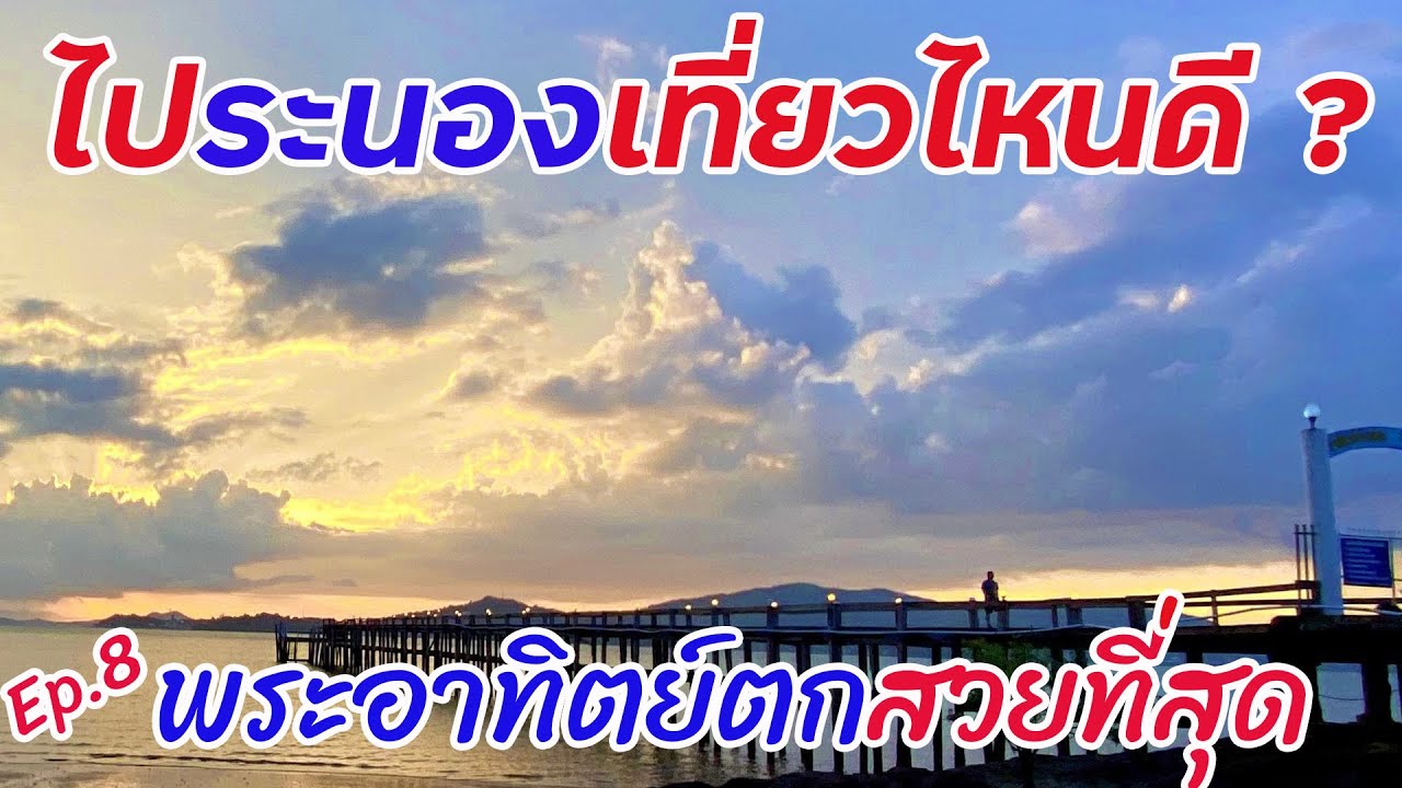
The most memorable image of Hat Chan Damri is its wooden pier extending toward the open water. On one side is the Ranong coastline; on the other side are islands, hills, and the Myanmar shore across the Kraburi River mouth. As the evening light falls across the sea, the area becomes a calm and atmospheric viewpoint where travelers can see boats, the local coastal community, and the Andaman horizon in one broad scene.
Hat Chan Damri is located in Pak Nam Subdistrict, Mueang Ranong District, Ranong Province, close to Jansom Beach Resort. The shoreline is relatively small and includes rocky sections, a coastal edge, a wooden pier, and a boat-landing area. For this reason, it is better known as a viewpoint and boat-access area than as a soft white-sand beach. Visitors usually come here to walk, take photographs, enjoy the sea breeze, watch the sunset, or begin a boat trip to nearby islands.
About 200 meters before reaching the beach, there is a raised hill viewpoint. This hill is one of the strongest features of Hat Chan Damri because it gives travelers a wider view of Pak Nam Ranong, the Kraburi River mouth, Kawthaung or Victoria Point in Myanmar, and the small islands scattered around the Andaman waters. The elevated view feels different from standing at the shoreline because it reveals the geographic shape of Ranong’s border coast more clearly.
The importance of Hat Chan Damri is closely tied to the Kraburi River mouth. This is where the river system opens toward the Andaman Sea, creating a landscape of Thai shoreline, offshore islands, and the nearby Myanmar coast. The beach is therefore not only a scenic seaside stop but also a place to understand Ranong’s border geography, coastal navigation, and local maritime life.
Kawthaung, also widely known as Victoria Point, is one of the key views from Hat Chan Damri. It lies across the water in Myanmar, opposite Ranong. Seeing the Myanmar coastal town from the Thai side gives the viewpoint a special cross-border character. It helps travelers understand how the sea, river mouth, boats, and border communities are closely connected in this part of the Andaman coast.
Hat Chan Damri also has a practical travel role because it is associated with a pier for tourist boats. Boat services from the Pak Nam Ranong area connect travelers with Ranong’s islands and surrounding Andaman routes, depending on the program, season, weather, and sea conditions. For visitors planning a marine trip, Hat Chan Damri can serve as both a scenic stop and a useful starting point.
The best time to visit is late afternoon before sunset. When the sky is clear, the sun drops toward the sea and reflects on the wooden pier, rocks, and water surface. The scene is especially photogenic because the Andaman horizon, distant islands, and Myanmar hills create a layered background. This is why Hat Chan Damri is often mentioned as one of Ranong’s notable sunset viewpoints.
Morning is also a good time for travelers who prefer a quieter mood. The light is soft, the air is cooler, and local boats may be seen moving through the river-mouth area. Morning visits are suitable for slow walks and relaxed observation, while evening visits are better for photography and the full sunset atmosphere.
Visitors should understand the natural character of the site. Hat Chan Damri is not primarily a swimming beach because it is close to the river mouth and includes rocks, a pier, and working coastal areas. The best activities are viewpoint photography, walking by the shore, enjoying a meal nearby, watching boats, and using the area as a gateway to Ranong’s island routes.
Jansom Beach Resort is a major landmark connected with Hat Chan Damri. The resort is located by the beach and is associated with the local boat pier area. It offers seaside accommodation, an outdoor pool, a restaurant, parking, and a private beach setting. Travelers may visit Hat Chan Damri as a short sunset stop or stay nearby for a quieter coastal experience close to Ranong town.
Another seasonal highlight is the yellow Mexican sunflower bloom on the hillside near the beach, usually associated with the November to December period. The scene is unusual because these flowers appear near the Andaman coast rather than on a northern mountain slope. When the flowers bloom with the sea and river mouth in the background, the area gains an additional visual charm.
Geographically, Hat Chan Damri helps explain Ranong well. Ranong is a province of mountains, rainforest, islands, estuaries, mangroves, coastal communities, and border waters. At Hat Chan Damri, travelers can see many of these elements in one place: hills, sea, river mouth, islands, boats, and the Myanmar side across the water.
The beach also tells the story of Ranong as a maritime town. Pak Nam Ranong has long been connected with boats, fishing, border trade, and island travel. The boats near the pier are not merely part of the scenery; they represent the everyday movement of people, goods, and visitors through the Andaman coastal landscape.
For photographers, Hat Chan Damri offers several types of images in a compact area. The wooden pier provides strong leading lines toward the sea. The hill viewpoint gives a higher perspective over the river mouth and islands. The rocky shoreline adds foreground detail. Sunset brings warm light, silhouettes, and reflections. Arriving 30 to 45 minutes before sunset gives enough time to choose the best angle.
For families, the site is easy to access from Ranong town and does not require a long walk. Elderly travelers can enjoy the view from easier areas, while children can watch boats and the sea under adult supervision. Care is still needed near the pier, rocks, and wet surfaces, especially after rain or at high tide.
Getting There is easiest by private car, rental car, or the Ranong – Pak Nam local transport route. From Ranong town, take Highway 4004 toward Pak Nam for about 9 kilometers. The route also passes near the Ranong Governor’s Grave. About 200 meters before the beach, the hill viewpoint offers a higher view over the coastal landscape.
A practical one-day route is to visit Ranong town’s cultural sites first, then end the day at Hat Chan Damri. Travelers can begin with the Rattanarangsan Palace Replica, the old governor-related sites, or Ho Phra Kao Kaeji Achan, continue to the Ranong Governor’s Grave, and finish at Hat Chan Damri for sunset. This route combines local history, town culture, and coastal scenery in one day.
The Ranong Governor’s Grave is a relevant nearby attraction because it is located on the same general route. It is connected with Phraya Damrong Sucharit Mahisorn Phakdi, also known as Kho Su Jiang, the first governor of Ranong and an important historical figure in the province. Pairing the grave with Hat Chan Damri gives travelers both historical and coastal perspectives on Ranong.
Ranong Lighthouse is another nearby stop related to the maritime character of the area. It reinforces the coastal and navigation theme of this part of Pak Nam Ranong. Travelers interested in sea routes, boats, and the visual identity of Ranong’s coast can include it before or after visiting the beach.
The Koh Phayam Pier is important for travelers continuing to Ranong’s islands. Visitors staying near Hat Chan Damri or exploring Pak Nam can plan onward boat travel to Koh Phayam or Koh Chang Ranong. Boat schedules and sea conditions should always be checked before traveling, because island routes depend on season, weather, and operator timetables.
Raksawarin Hot Springs can also be paired with Hat Chan Damri for a balanced Ranong itinerary. One site offers hot mineral water and a relaxing park atmosphere, while the other offers sea views and sunset. Combining the two gives travelers a fuller experience of Ranong’s nature-based tourism.
Food is another reason to spend time around Pak Nam. The area near Hat Chan Damri has several seafood restaurants and seaside cafés, including KeingLay Ranong, Somyot Pak Nam Seafood, Pak Nam Seafood, and The Blue Sky Restaurant. These places reflect Ranong’s coastal food culture, with seafood, southern flavors, and sea-view dining playing an important role in the travel experience.
Travelers looking for dinner after sunset should consider seafood restaurants in Pak Nam or restaurants connected with nearby resorts. Some places offer open-air seating, coastal views, and local dishes based on Andaman seafood. This makes an evening at Hat Chan Damri easy to combine with a relaxed meal by the sea.
Nearby accommodation ranges from seaside resorts in Pak Nam to hotels in Ranong town. Travelers who want to stay close to the water can choose properties such as Jansom Beach Resort, B.C. Badin Resort, Mrs. Swan Hotel, The Blue Sky Resort Ranong, or Ruean Bai Liang Resort. Those who prefer easier access to markets, shops, and town facilities can stay in central Ranong and visit Hat Chan Damri in the evening.
Weather matters in Ranong because the province receives frequent rainfall. On rainy days, the sky may be closed and sunset visibility may be limited. Wet wooden surfaces and rocks can also be slippery. The late rainy season to the drier months often gives good scenery, while the rainy season offers lush green surroundings but requires more preparation.
Useful items to bring include a camera or phone suitable for sunset photography, comfortable walking shoes, a light jacket, drinking water, and insect repellent if staying until evening. Visitors planning to take a boat should use a clear operator, wear a life jacket, and follow boat crew instructions.
Safety is important around the wooden pier, rocky shore, and boat area. Visitors should not climb railings, stand on wet rocks, block boat access, or let children walk near the edge unsupervised. After rain or during high tide, the shoreline and pier areas require extra caution.
Hat Chan Damri is suitable for sunset seekers, photographers, couples, families, island travelers, and anyone interested in Ranong’s border landscape. Its strength is its simplicity: a small coastal place that reveals the sea, river mouth, islands, boats, local community, and Myanmar side in one view.
Overall, Hat Chan Damri completes a Ranong travel route by linking the town with the sea. It connects local history, Pak Nam community life, island travel, sunset scenery, and Andaman border geography. Travelers who want to understand Ranong beyond hot springs and Koh Phayam should spend at least one evening here and watch the last light of the day over the river mouth and the Andaman Sea.
| Name | Hat Chan Damri |
| Location | Pak Nam Subdistrict, Mueang Ranong District, Ranong Province 85000, Thailand |
| Address | Multipurpose pier and coastal area near Jansom Beach Resort, Pak Nam Subdistrict, Mueang Ranong District, Ranong Province |
| Highlights | Views of the Kraburi River mouth, Pak Nam Ranong community, Kawthaung or Victoria Point in Myanmar, Andaman islands, wooden pier, tourist boat pier, and sunset |
| Distinctive Features | Small coastal beach with rocks, shoreline, wooden pier, boat-landing area, and a hill viewpoint about 200 meters before the beach |
| Importance | A viewpoint over the Kraburi River mouth and a coastal gateway for tourist boats to Ranong’s Andaman islands |
| Travel Information | From Ranong town, take Highway 4004, the Ranong – Pak Nam route, for about 9 km. Local Ranong – Pak Nam transport can also be used |
| Current Status | Open as a coastal viewpoint, beach area, tourist boat pier, and seaside leisure area in Pak Nam Subdistrict |
| Open Days | Daily |
| Opening Hours | 24 Hours |
| Best Time To Visit | Late afternoon for sunset and photography; morning for quiet coastal scenery and local boat activity |
| Facilities | Tourist boat pier, wooden pier, viewpoint, seaside restaurants, nearby accommodation, and parking areas around nearby resorts/restaurants |
| Main Areas / Zones | 1. Hat Chan Damri shoreline 2. Wooden pier and tourist boat pier 3. Hill viewpoint about 200 meters before the beach 4. Jansom Beach Resort area 5. Kraburi River mouth and Kawthaung view zone |
| Local Caretaker | Pak Nam Subdistrict Municipality, Mueang Ranong District, Ranong Province |
| Main Contact Number | Pak Nam Subdistrict Municipality, Tel. 077-816302 |
| Official Website / Official Page | Pak Nam Subdistrict Municipality website and CBT Thailand tourism information system |
| Nearby Tourist Attractions | 1. Ranong Lighthouse, about 2 km 2. Ranong Governor’s Grave, about 8 km 3. Koh Phayam Pier, about 8 km 4. Ho Phra Kao Kaeji Achan, about 11 km 5. Rattanarangsan Palace Replica, about 11 km 6. Raksawarin Hot Springs, about 13 km |
| Nearby Restaurants | 1. KeingLay Ranong, about 1 km, Tel. 077-831099 2. SEA SWAN - HAPPINESS SPACE, about 1 km 3. The Blue Sky Restaurant, about 2 km, Tel. 077-873958 4. Pak Nam Seafood Ranong, about 5 km, Tel. 081-978-3640 5. Somyot Pak Nam Seafood, about 6 km, Tel. 077-810-965, 083-647-2357 6. Ranong O Cha Dim Sum, about 12 km |
| Nearby Accommodations | 1. Jansom Beach Resort, about 1 km, Tel. 077-810510-1, 081-9581797 2. B.C. Badin Resort, about 1 km, Tel. 077-880822-3, 085-4497381 3. Mrs. Swan Hotel, about 1 km, Tel. 090-9688218, 086-3042628 4. The Blue Sky Resort Ranong, about 2 km, Tel. 077-873958, 082-4577801 5. Ruean Bai Liang Resort, about 3 km, Tel. 077-871113, 085-0682755 6. Kaw Ta Ranong Hostel, about 6 km, Tel. 082-2046090, 081-5977216 |
Frequently Asked Questions (FAQ)
Q: Where is Hat Chan Damri located?
A: Hat Chan Damri is in Pak Nam Subdistrict, Mueang Ranong District, Ranong Province, about 9 km from Ranong town along Highway 4004, the Ranong – Pak Nam route.
Q: What is interesting about Hat Chan Damri?
A: It is known for views of the Kraburi River mouth, Pak Nam Ranong community, Kawthaung or Victoria Point in Myanmar, the wooden pier, tourist boat pier, and Andaman sunset scenery.
Q: Is Hat Chan Damri good for swimming?
A: Hat Chan Damri is better for sightseeing, photography, walking, and boat access than swimming because the area has rocks, a pier, and river-mouth coastal conditions.
Q: When is the best time to visit Hat Chan Damri?
A: Late afternoon before sunset is the best time for photography and sea views. Morning is suitable for a quieter atmosphere and soft light over the river mouth.
Q: How do travelers get to Hat Chan Damri?
A: From Ranong town, take Highway 4004 toward Pak Nam for about 9 km. The Ranong – Pak Nam local transport route can also be used.
Q: How is Hat Chan Damri connected with Jansom Beach Resort?
A: Jansom Beach Resort is located by Hat Chan Damri, and the area includes a tourist boat pier serving island routes in Ranong’s Andaman waters.
Q: What nearby attractions can be combined with Hat Chan Damri?
A: Travelers can combine it with the Ranong Governor’s Grave, Ranong Lighthouse, Koh Phayam Pier, Rattanarangsan Palace Replica, Ho Phra Kao Kaeji Achan, and Raksawarin Hot Springs.
Q: What should visitors be careful about at Hat Chan Damri?
A: Visitors should walk carefully on the wooden pier, rocks, and boat areas, especially after rain or at high tide. Children should be supervised near the water.
 Category: ●Nature and Wildlife
 Group: ●Bays and Beaches
Last Update : 2 MonthAgo
 Last Update : 2 MonthAgo
 Click to Access the Navigation Map GPS
Hat Chan Damri Map
Recommend

 Art, Culture and Heritage
 Historical Sites and Monuments(4)
 Landmarks and Memorials(1)
 Royal Palace(1)
 Art, Craft Centres, Tradition(4)
 Educational Places
 Educational Gardens, Farm(1)
 Places of Worship
 Temple(12)
 Other Sacred Sites(2)
 Suburban Living
 Village, Community(2)
 National Parks and Marine Reserves(6)
 Mountain (Doi)(4)
 Waterfalls(15)
 Hot Springs(3)
 Caves(4)
 River, Canal(2)
Bays and Beaches(10)
 Islands(8)
 Other natural attractions(3)
 Travel Articles, Recipes
 Travel Review, Food Review(1)


