
lovethailand home >South Travel Attractions >Phatthalung Travel Attractions >Pa Bon >Thung Na Ri > Klong Pa Bon Reservoir
TL;DR: Klong Pa Bon Reservoir is located at Ban Lo Han, Moo 7, Thung Nari Subdistrict, Pa Bon District, Phatthalung Province, open Daily, hours 08.00 – 18.00.

Klong Pa Bon Reservoir
Open Days: Daily
Opening Hours: 08.00 – 18.00
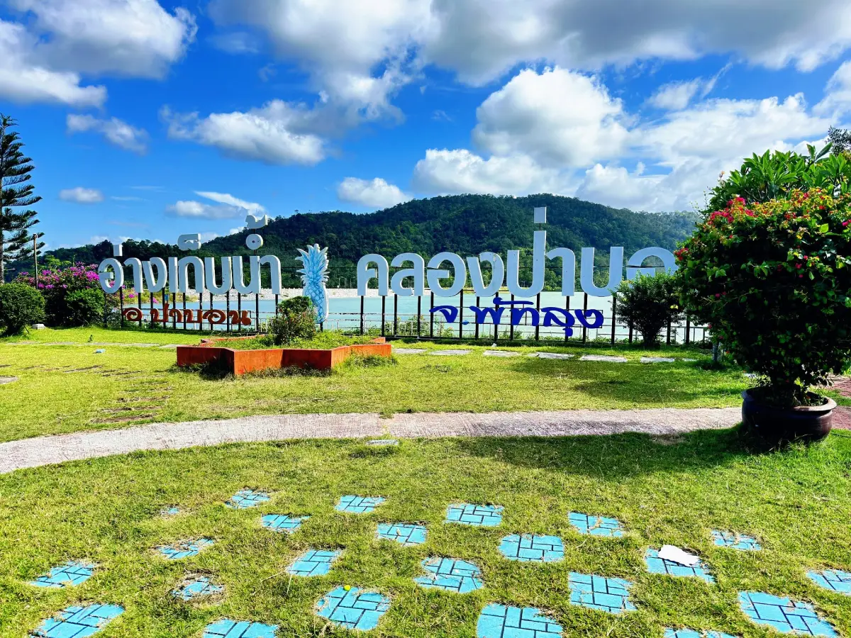
Khlong Pa Bon Reservoir in Phatthalung is a medium-sized reservoir located at Ban Lo Han, Moo 7, Thung Nari Subdistrict, Pa Bon District. Built by the Royal Irrigation Department in a valley near the Banthat mountain range, it covers about 2,000 rai and serves as an important water source for agriculture, household use, and flood mitigation. Its main attractions are the wide reservoir view, surrounding mountains, a 1,500-meter waterside walkway, 8 resting pavilions, and a peaceful natural atmosphere suitable for relaxing, photography, and slow travel.
Khlong Pa Bon Reservoir, also known as Pa Bon Reservoir or Khlong Pa Bon Reservoir under the Royal Development Project, is one of the most important water sources in Pa Bon District, Phatthalung Province. It is located at Ban Lo Han, Moo 7, Thung Nari Subdistrict, in a valley setting surrounded by hills and forested landscape. The reservoir is significant both as irrigation infrastructure and as a quiet natural attraction where visitors can enjoy water, mountains, open sky, and a slower rural atmosphere.
The reservoir covers about 2,000 rai and was built by the Royal Irrigation Department at the upper section of Khlong Pa Bon. Its main purpose is to store water for agricultural use, local water security, and downstream communities. The surrounding landscape includes mountain slopes, forest, and farming communities in Pa Bon District. From the reservoir crest and viewpoint areas, visitors can see the broad water surface framed by green mountains, giving the place a spacious and peaceful character.
The importance of Khlong Pa Bon Reservoir extends far beyond tourism. It is a Royal Development Project created to address water shortages in agricultural areas that relied heavily on rainfall. During dry periods or rainless intervals, local farmers previously faced water scarcity and unstable crop production. The reservoir was therefore developed as an upstream water-storage project to supply water to downstream irrigation areas and help improve agricultural reliability.
Historically, Khlong Pa Bon Reservoir was implemented during the fiscal years 1994 to 2000 and completed in 2000. The project was designed as a water-storage system supporting the Khlong Pa Bon diversion weir and agricultural areas downstream. Its role is directly connected to rice farming, fruit cultivation, local livelihoods, and the broader water-management system of Phatthalung Province.
The most memorable feature of Khlong Pa Bon Reservoir is its mountain-reservoir landscape. The reservoir sits in a valley where the water, hills, and forest create a calm visual composition. A waterside walkway of about 1,500 meters follows the edge of the reservoir and forested area, allowing visitors to walk slowly along the water. There are also 8 pavilions where visitors can rest and enjoy the view. These features make the reservoir suitable for quiet relaxation rather than crowded entertainment.
The best times to visit are early morning and late afternoon. Morning gives the area a fresh, cool feeling, while late afternoon offers softer light over the water and mountains. The reservoir crest, waterside walkway, and pavilions are the most suitable areas for photography and short breaks. The scenery is simple but impressive, especially for travelers who enjoy open water views and natural mountain backdrops.
In addition to the scenery, the reservoir area also includes a place to pay respect to Luang Pu Thuat, a revered Buddhist monk widely respected in southern Thailand. This adds a spiritual element to the visit, making the reservoir not only a scenic stop but also a place where travelers can experience local faith and quiet reflection.
From an irrigation perspective, Khlong Pa Bon Reservoir has a normal storage capacity of about 20 million cubic meters and a rainfall catchment area of about 29.70 square kilometers. Royal Irrigation Department station data also identifies engineering details such as reservoir dimensions, water levels, and spillway capacity. These facts show that the reservoir is an important water-management structure, not merely a recreational landscape.
The Royal Irrigation Department has continued to monitor and improve the reservoir. A project to increase the water-storage potential of Khlong Pa Bon Reservoir was carried out to strengthen the reservoir structure and improve long-term storage capacity. These improvements help the reservoir remain a key water source for household use, agriculture, flood mitigation, and long-term water security in Phatthalung.
The reservoir also plays an important role in receiving water from the Banthat mountain range, the mountain system separating Phatthalung and Trang provinces. During heavy rainfall, water from the mountains flows into the reservoir. Reservoir management is therefore important for storing water during dry periods and controlling releases to reduce downstream impacts during heavy-rain events.
The current status of Khlong Pa Bon Reservoir remains that of an important water source and nature attraction in Pa Bon District. In late August 2026, local reports stated that the water level had dropped significantly, affecting water-supply production in the area. Local authorities asked residents to store water and use water sparingly. Visitors should therefore respect the reservoir as an active community water source, keep the area clean, and follow local announcements when planning activities near the water.
For travelers, Khlong Pa Bon Reservoir is best suited for quiet sightseeing, short walks, photography, and resting by the water. It is not a commercial theme-style attraction. The most appropriate activities are viewing the reservoir, walking along the waterside path, sitting in the pavilions, taking photos of the water and mountains, and paying respect to Luang Pu Thuat. Since the reservoir is part of a working irrigation system, visitors should avoid any activity that could affect water quality or disturb the area.
The reservoir also connects naturally with other attractions in Thung Nari and nearby subdistricts, including Mae Taeng Waterfall, Nan Fa Waterfall, Nong Thong Mist Viewpoint, Lung Than Salak Garden, and Ton Sato Waterfall. Some forest and waterfall routes require physical readiness and local guidance, especially those located deeper in the Banthat mountain forest. Travelers who plan to extend the trip into waterfall or forest areas should prepare proper footwear and travel with local knowledge.
As part of a Pa Bon travel route, Khlong Pa Bon Reservoir can serve as the main nature stop. A half-day itinerary can begin at the reservoir in the morning, continue with a walk along the waterside path, a rest at one of the pavilions, and a visit to the Luang Pu Thuat worship area. After that, travelers can continue to local cafés, restaurants, or nearby agricultural attractions such as Lung Than Salak Garden. A full-day route can also include Ton Sato Waterfall, Mae Taeng Waterfall, or Nong Thong Mist Viewpoint.
Weather matters when visiting Khlong Pa Bon Reservoir. On clear days, the mountain view is more open and the water surface reflects the sky beautifully. After rain, the forest and mountain slopes appear greener, but visitors should be careful on wet roads and avoid unstable slopes near the reservoir. During dry periods, the scenery may change with the water level, but the place still reveals its role as an essential stored-water source for the district.
Photographers will find several good angles at the waterside walkway, pavilions, reservoir crest, and mountain-facing viewpoints. The scenery is not overly dramatic, but it has a calm and open quality that works well for rural nature photography. Late afternoon light can create soft reflections on the water, making the reservoir especially suitable for peaceful travel images.
For the local community, Khlong Pa Bon Reservoir is a multi-purpose place. It is a Royal Development Project, an irrigation reservoir, a flood-mitigation structure, an agricultural water source, and a public recreation area. Understanding this wider role makes the visit more meaningful. The water in front of visitors is connected to farming, household use, drought management, and the safety of downstream communities.
Responsible travel is essential here. Visitors should take rubbish away, avoid dumping food waste into the water, avoid noisy behavior, and respect restricted or operational areas managed by irrigation officers. The reservoir is both a tourism site and a working water source, so careful behavior helps keep it clean, safe, and useful for local people.
Getting There is most convenient by private car or rental car. From Phatthalung town, travel toward Pa Bon District, then continue to Thung Nari Subdistrict and Ban Lo Han, Moo 7. The route passes rural and foothill landscapes. Drivers should be careful during and after rainfall, especially on roads near slopes and reservoir areas.
For a half-day trip, travelers can visit Khlong Pa Bon Reservoir in the morning, walk along the reservoir edge, rest at the pavilions, and enjoy the mountain scenery. Then continue to a café or restaurant in Pa Bon District before visiting Lung Than Salak Garden or Ton Sato Waterfall. For a full-day trip, Mae Taeng Waterfall, Nan Fa Waterfall, and Nong Thong Mist Viewpoint can be added, depending on weather and route conditions.
In summary, Khlong Pa Bon Reservoir is more than a medium-sized reservoir in Phatthalung. It combines royal-development history, irrigation value, mountain scenery, community livelihood, and peaceful nature in one place. Travelers looking for a quiet, meaningful, and scenic stop in Pa Bon District should include Khlong Pa Bon Reservoir in their Phatthalung route.
| Name | Khlong Pa Bon Reservoir |
| Alternative Names | Pa Bon Reservoir / Khlong Pa Bon Reservoir Under the Royal Development Project |
| Location | Ban Lo Han, Moo 7, Thung Nari Subdistrict, Pa Bon District, Phatthalung Province |
| Address | Moo 7, Ban Lo Han, Thung Nari Subdistrict, Pa Bon District, Phatthalung 93170, Thailand |
| Coordinates | 7.119914297, 100.0849158 |
| Highlights | Valley reservoir, wide water view, mountain scenery, 1,500-meter waterside walkway, and 8 resting pavilions |
| History | Royal Development Project implemented from fiscal year 1994 to 2000 and completed in 2000 |
| Distinctive Features | Medium-sized reservoir covering about 2,000 rai, surrounded by mountains and forest near the Banthat mountain range |
| Reservoir Capacity | Normal storage capacity of about 20 million cubic meters |
| Rainfall Catchment Area | About 29.70 square kilometers |
| Importance | Important source of water for agriculture, household use, and flood mitigation in Pa Bon and downstream benefit areas |
| Travel Information | Travel from Phatthalung town to Pa Bon District, then continue to Thung Nari Subdistrict and Ban Lo Han, Moo 7; private car or rental car is recommended |
| Current Status | Still an important water source and natural attraction; in late August 2026, local authorities reported a significant drop in water level and asked residents to use water sparingly |
| Open Days | Daily |
| Opening Hours | 08.00 – 18.00 |
| Fees | No admission fee |
| Facilities | Waterside walkway, resting pavilions, viewpoint area, and Luang Pu Thuat worship area |
| Main Areas / Zones | Reservoir crest, waterside walkway, 8 resting pavilions, water-and-mountain viewpoints, and Luang Pu Thuat worship area |
| Caretaker / Local Authority | Royal Irrigation Department and local authorities in Thung Nari Subdistrict |
| Main Contact Number | Thung Nari Subdistrict Administrative Organization, Tel. 074-820-359 |
| Official Website / Official Page | Royal Irrigation Department Website / RDPB Website / Phatthalung Provincial Website / Thung Nari SAO Website |
| Nearby Tourist Attractions | 1. Mae Taeng Waterfall, about 3 km 2. Nan Fa Waterfall, about 5 km 3. Nong Thong Mist Viewpoint, about 13 km 4. Lung Than Salak Garden, about 16 km 5. Ton Sato Waterfall, about 18 km |
| Nearby Restaurants | 1. Friendship Coffee & Bar Pa Bon, about 16 km, Tel. 062-037-1451, 099-235-0299 2. Phak Phing Ing Thang Coffee, about 16 km, Tel. 074-841-638, 083-020-0703 3. Ko'made Cafe & Restaurant, about 17 km, Tel. 082-889-7898 4. Khrua Phuean Phochana Pa Bon, about 18 km, Tel. 098-952-6920 5. Bang Meen Kai Op Ong Pa Bon Branch, about 19 km, Tel. 089-291-2851 |
| Nearby Accommodations | 1. Grace Room Resort, about 15 km, Tel. 093-574-4958 2. Grace Room Resort, about 15 km, Tel. 064-493-6519 3. Baan Jae Wae Homestay, about 17 km, Tel. 088-832-5352 4. Saensuk 2 Resort, about 20 km, Tel. 065-955-4895 5. Dahla Resort, about 21 km, Tel. 061-990-0676 |
Frequently Asked Questions (FAQ)
Q: Where is Khlong Pa Bon Reservoir located?
A: It is located at Ban Lo Han, Moo 7, Thung Nari Subdistrict, Pa Bon District, Phatthalung Province.
Q: What are the main highlights of Khlong Pa Bon Reservoir?
A: Its highlights include a wide reservoir view in a valley, surrounding mountains, a 1,500-meter waterside walkway, 8 resting pavilions, and a peaceful natural atmosphere.
Q: Is Khlong Pa Bon Reservoir a Royal Development Project?
A: Yes. It is a Royal Development Project built by the Royal Irrigation Department to store water, support agriculture, and improve local water security.
Q: Is there an admission fee?
A: No. There is no admission fee.
Q: When is the best time to visit Khlong Pa Bon Reservoir?
A: Morning and late afternoon are the best times because the weather is more comfortable and the light is suitable for viewing the reservoir and mountains.
Q: What activities are suitable at Khlong Pa Bon Reservoir?
A: Suitable activities include walking along the reservoir, taking photos, resting in the pavilions, paying respect to Luang Pu Thuat, and enjoying quiet nature.
Q: How can travelers get to Khlong Pa Bon Reservoir?
A: Travel from Phatthalung town toward Pa Bon District, then continue to Thung Nari Subdistrict and Ban Lo Han, Moo 7. A private car or rental car is the most convenient option.
Q: What nearby attractions can be visited with Khlong Pa Bon Reservoir?
A: Travelers can combine the reservoir with Mae Taeng Waterfall, Nan Fa Waterfall, Nong Thong Mist Viewpoint, Lung Than Salak Garden, and Ton Sato Waterfall.
 Category: ●Nature and Wildlife
 Group: ●Dam, Reservoir, Lake
Last Update : 2 MonthAgo
 Last Update : 2 MonthAgo
 Click to Access the Navigation Map GPS
Klong Pa Bon Reservoir Map
Recommend

 Art, Culture and Heritage
 Historical Sites and Monuments(1)
 Landmarks and Memorials(1)
 Art, Craft Centres, Tradition(6)
 Historic Homes and Cities(1)
 Educational Places
 Educational Gardens, Farm(1)
 Places of Worship
 Temple(25)
 Other Sacred Sites(4)
 Research and Development
 Royal Project(2)
 Suburban Living
 Village, Community(3)
 National Parks and Marine Reserves(3)
 Mountain (Doi)(4)
Dam, Reservoir, Lake(7)
 Waterfalls(16)
 Hot Springs(2)
 Caves(12)
 River, Canal(5)
 Bays and Beaches(6)
 Islands(2)
 Other natural attractions(4)
 Entertainment and Agricultural
 Farms, Parks and Ecotourism(4)
 Travel Articles, Recipes
 Travel Review, Food Review(1)


