
lovethailand home >South Travel Attractions >Phatthalung Travel Attractions >Si Banphot >Khao Pu > Riang Thong Waterfall
TL;DR: Riang Thong Waterfall is located at Moo 1, Khao Pu Subdistrict, Si Banphot District, Phatthalung Province, open Daily, Except During The Annual Nature-Recovery Closure, hours 08:00 – 16:00.

Riang Thong Waterfall
Open Days: Daily, Except During The Annual Nature-Recovery Closure
Opening Hours: 08:00 – 16:00
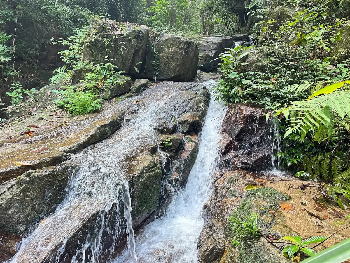
Riang Thong Waterfall in Phatthalung Province is an important natural waterfall inside Khao Pu-Khao Ya National Park. It is located in Moo 1, Khao Pu Subdistrict, Si Banphot District, about 2 km from Ban Khao Pu community. The waterfall is one of the most distinctive natural attractions in the Khao Pu-Khao Ya forest landscape. Its water originates from the Banthat Range and the Nakhon Si Thammarat mountain range, flowing down through layers of forested slopes and rock formations before becoming a long series of cascades. Because the water drops through many natural levels along the route, the waterfall is also known as the “Hundred-Tier Waterfall.”
The name Riang Thong comes from the riang trees that grow in large numbers around the waterfall. Riang is a plant known in southern Thailand and closely associated with local forest and food culture. The name therefore reflects not only the physical landscape but also the relationship between local plants, forest ecology, and the community around Khao Pu. The alternative name Hundred-Tier Waterfall describes the way the stream descends continuously over many rocky levels, creating a long and varied nature trail rather than a single waterfall pool.
Riang Thong Waterfall is about 240 meters above sea level. Its stream flows down from rocky cliffs and slopes in a long natural line. The national park has arranged a nature-study trail that allows visitors to walk into the waterfall area more conveniently than many deeper forest waterfalls. Along the trail, visitors can observe changing stream patterns, small pools, rock surfaces, wet forest plants, and shaded evergreen forest. The waterfall is best experienced slowly, with time to stop at different levels rather than rushing directly to the upper section.
The most famous section is the 13th tier, which is considered especially beautiful and has a scenic resting point. From this level, visitors can see a wide landscape including Thale Noi Non-Hunting Area, Khao Pu, and Khao Ya, with the mountains standing out from the surrounding plains. This viewpoint makes Riang Thong more than a waterfall for water recreation. It is also a highland viewpoint that reveals the wider geography of Phatthalung.
Khao Pu-Khao Ya National Park is Thailand’s 42nd national park and covers about 433,750 rai across Phatthalung, Nakhon Si Thammarat, and Trang provinces. The park is dominated by complex mountain ranges and year-round humid evergreen forest. This forest is often described as a pristine southern forest landscape. Riang Thong Waterfall is therefore part of a larger protected ecosystem that functions as a headwater forest, wildlife habitat, plant conservation area, and nature-learning destination.
The main activities at Riang Thong Waterfall include nature-trail walking, waterfall sightseeing, birdwatching, plant observation, viewpoint photography, and quiet forest relaxation. The trail provides opportunities to observe streamside vegetation, ferns, mosses, evergreen forest plants, and rock surfaces shaped by flowing water. Some aquatic life can also be found in the waterfall area, showing the ecological value of the stream.
This waterfall is best suited to travelers who enjoy walking and nature observation. Although the national park provides a trail for visitors, reaching multiple tiers still requires effort and caution. Rocks can be slippery from moisture and moss, especially after rain. Families with children or older visitors should choose only suitable trail sections and should avoid climbing higher levels during unsafe weather.
The best time to visit is from morning to early afternoon because daylight is important for seeing the path, rocks, water level, and stream conditions clearly. The waterfall is most attractive when there is sufficient seasonal water, but visitors should avoid walking or entering water when there is heavy rain, cloudy water, strong current, or any sign of flash-flood risk. Riang Thong is a mountain-stream waterfall, so official safety guidance from park staff should always be followed.
Khao Pu-Khao Ya National Park has an annual closure period for tourism and overnight stays, generally from mid-November to late December. This closure allows the natural environment to recover and supports visitor safety. Waterfall attractions in the park, including Riang Thong, Nan Plio, Khuan Pra, Pak Chaem, and Thara Warin, are part of the seasonal conservation management system. Visitors should plan their trip outside the annual closure period.
Safety preparation is important. Visitors should wear shoes with good grip, carry drinking water, bring a towel and a change of clothes, protect phones with waterproof bags, and carry rubbish out of the area. While walking along the waterfall trail, visitors should move carefully, avoid wet rocks, avoid waterfall edges, stay on the marked route, and avoid entering strong currents.
For photography, Riang Thong Waterfall offers many natural scenes: water flowing through rock layers, shaded forest streams, riang trees and other local plants, small pools, nature-study paths, and the viewpoint from the 13th tier. The key photographic appeal is the long sequence of cascades and forest atmosphere rather than a single dramatic vertical drop.
Nearby attractions within Khao Pu-Khao Ya National Park include Tham Matcha Pla Won, Tham Ruen Thep Nimit or Tham Ta Pu, Pha Phueng Viewpoint, Tarzan-style park lodging, Nan Plio Waterfall, Khuan Pra Waterfall, Pak Chaem Waterfall, and Thara Warin Waterfall. Tham Matcha Pla Won is a medium-sized cave with large chambers and a water pool with fish, while Tham Ruen Thep Nimit is connected with local belief surrounding Khao Pu. Pha Phueng Viewpoint is close to the park headquarters and is known for seasonal giant honeybee nests.
Ban Khao Pu community is an important base for visiting Riang Thong Waterfall. The community lies close to the park and is connected with local belief in Khao Pu as a sacred mountain. A trip to Riang Thong can be combined with Ban Khao Pu, Wat Tham Kao, nearby caves, and community-based tourism activities. This allows visitors to understand not only the waterfall but also local life, food, and cultural memory around Khao Pu.
Getting There from Phatthalung town can be done by two main routes. The first route follows Highway 41 toward Nakhon Si Thammarat for about 20 km to Pho Thong Intersection, then turns left onto Highway 4164, the Khuan Khanun-Khao Pu road, for about 17 km. From there, turn left at the national park sign and continue about 4 km to Khao Pu-Khao Ya National Park headquarters.
The second route uses Highway 4 from Phatthalung toward Trang for about 17 km to Khuan Din So Intersection, then turns right toward Khao Pu for about 27 km. After reaching Khao Pu community, turn right for about 3 km to the park sign, then continue uphill for about 4 km to the national park headquarters. This route is useful for travelers connecting from the Phatthalung-Trang side.
After arriving at the national park, visitors should park in the designated area and contact park staff or the visitor center for current trail, water, and safety conditions before entering the waterfall route. Park facilities include parking, toilets, visitor services, accommodations, restaurants, and a camping area. Travelers staying overnight should prepare personal equipment and follow national park regulations.
A practical half-day itinerary begins from Phatthalung town in the morning, continues to Khao Pu-Khao Ya National Park, then follows the nature-study trail to Riang Thong Waterfall. Visitors can spend 2–3 hours walking and photographing the waterfall before adding Pha Phueng Viewpoint or Tham Matcha Pla Won. This plan is suitable for travelers who want to focus on the waterfall and national park forest.
A full-day route can include Riang Thong Waterfall, Tham Matcha Pla Won, Tham Ruen Thep Nimit, Pha Phueng Viewpoint, the park’s Tarzan-style accommodation area, and Ban Khao Pu community. Visitors should begin early and adjust the number of stops according to weather, trail conditions, and physical ability. Those who want to stay overnight can use national park accommodation or choose lodging in nearby areas such as Si Banphot, Khuan Khanun, or Phatthalung town.
Riang Thong Waterfall is more than a scenic waterfall in Phatthalung. It combines the origin of its name from riang trees, the long Hundred-Tier Waterfall character, a nature-study trail, the 13th-tier viewpoint, Ban Khao Pu community context, and the ecological role of Khao Pu-Khao Ya National Park. With careful travel, respect for park rules, and responsible behavior, it remains one of the most valuable natural destinations in Phatthalung.
| Name | Riang Thong Waterfall |
| Alternative Name | Hundred-Tier Waterfall / Namtok Riang Thong |
| Location | Moo 1, Khao Pu Subdistrict, Si Banphot District, Phatthalung Province |
| Address / Navigation Area | Inside Khao Pu-Khao Ya National Park, Moo 1, Khao Pu Subdistrict, Si Banphot District, Phatthalung 93190, Thailand |
| Coordinates | Approximately 7.703560, 99.810585 |
| Elevation | About 240 meters above sea level |
| Highlights | Multi-tiered waterfall in Khao Pu-Khao Ya National Park, also known as Hundred-Tier Waterfall; the 13th tier has a viewpoint overlooking Thale Noi, Khao Pu, and Khao Ya |
| Name Origin | The name Riang Thong comes from riang trees that grow abundantly around the waterfall; the Hundred-Tier name comes from the many cascading levels of the stream |
| Main Activities | Nature-trail walking, waterfall sightseeing, birdwatching, plant observation, viewpoint photography, and relaxing in humid evergreen forest |
| Travel Information | From Phatthalung town, use Highway 41 to Pho Thong Intersection and continue on Highway 4164 toward Khao Pu, or use Highway 4 to Khuan Din So Intersection and continue toward Khao Pu community |
| Current Status | Open as a natural attraction in Khao Pu-Khao Ya National Park, except during the annual nature-recovery closure |
| Open Days | Daily, except during the annual nature-recovery closure |
| Opening Hours | 08:00 – 16:00 |
| Annual Closure | 15 November – 25 December every year |
| Admission Fee | Thai Adults 20 Baht, Thai Children 10 Baht / Foreign Adults 100 Baht, Foreign Children 50 Baht |
| Facilities | Parking, toilets, visitor center, accommodation, restaurant, camping area, and nature-study trail |
| Main Areas / Zones | Nature-study trail, waterfall tiers, stream, pools, 13th-tier viewpoint, visitor center, accommodation, Tarzan-style lodging area, Pha Phueng Viewpoint, and camping area |
| Caretaker | Khao Pu-Khao Ya National Park, Department Of National Parks, Wildlife And Plant Conservation |
| Contact | Khao Pu-Khao Ya National Park, Tel. 074-689-194, 093-578-9749 |
| Safety Note | Avoid the waterfall during heavy rain, cloudy water, or strong current. Stay on the marked trail, avoid slippery rocks, and follow park staff instructions |
| Nearby Tourist Attractions | 1. Khao Pu-Khao Ya National Park Headquarters, about 4 km 2. Ban Khao Pu, about 2 km 3. Pha Phueng Viewpoint, about 4 km 4. Tham Matcha Pla Won, about 6 km 5. Tham Ruen Thep Nimit / Tham Ta Pu, about 8 km 6. Wat Tham Kao, Ban Na Wat Tham, about 10 km |
| Nearby Restaurants | 1. Restaurant Inside Khao Pu-Khao Ya National Park, about 4 km 2. Ban Khun Ta Restaurant, Si Banphot, about 8 km, Tel. 065-394-2326 3. 279 Home Cafe Si Banphot Phatthalung, about 9 km, Tel. 086-943-0788 4. Larn Ta Chu Steakhouse Khuan Khanun, about 25 km, Tel. 074-681-658, 081-957-6428 5. Khao Kaeng Sam Phi Nong Khuan Khanun, about 26 km, Tel. 061-212-6747, 097-114-0029 6. Rua Mai Food And Drink, about 28 km, Tel. 098-626-3077 |
| Nearby Accommodations | 1. Khao Pu-Khao Ya National Park Accommodation And Camping Area, about 4 km, Tel. 074-689-194, 093-578-9749 2. Mo Nuea Khao Pu Community Tourism, about 8 km, Tel. 081-969-3656 3. Khon Khao Ya Community Tourism, Si Banphot, about 12 km, Tel. 085-163-3248 4. Saipo Homestay Khuan Khanun, about 30 km, Tel. 093-774-7360 5. Varni Homestay, about 35 km 6. Sri Pakpra Boutique Resort Phatthalung, about 45 km, Tel. 061-149-9494 |
Frequently Asked Questions (FAQ)
Q: Where Is Riang Thong Waterfall Located?
A: Riang Thong Waterfall is located in Moo 1, Khao Pu Subdistrict, Si Banphot District, Phatthalung Province, inside Khao Pu-Khao Ya National Park.
Q: Why Is Riang Thong Called The Hundred-Tier Waterfall?
A: The stream flows down the mountain through many natural rock levels, creating a long sequence of cascades. This is why it is also called the Hundred-Tier Waterfall.
Q: What Are The Opening Hours?
A: The waterfall is in Khao Pu-Khao Ya National Park, which is generally open from 08:00 to 16:00, except during the annual nature-recovery closure.
Q: When Is Riang Thong Waterfall Closed?
A: Khao Pu-Khao Ya National Park generally closes tourism and overnight stays from 15 November to 25 December every year for nature recovery and visitor safety.
Q: What Are The Main Highlights?
A: The highlights include the long multi-tiered stream, the riang trees that gave the waterfall its name, the humid evergreen forest, the nature-study trail, and the 13th-tier viewpoint overlooking Thale Noi, Khao Pu, and Khao Ya.
Q: How Do Travelers Get There?
A: From Phatthalung town, use Highway 41 to Pho Thong Intersection, then take Highway 4164 toward Khao Pu, or use Highway 4 to Khuan Din So Intersection and continue toward Khao Pu community and the national park.
Q: What Activities Are Suitable At Riang Thong Waterfall?
A: Suitable activities include nature-trail walking, waterfall sightseeing, birdwatching, plant observation, viewpoint photography, and quiet relaxation in the national park forest.
Q: What Attractions Are Nearby?
A: Nearby attractions include Khao Pu-Khao Ya National Park Headquarters, Ban Khao Pu, Pha Phueng Viewpoint, Tham Matcha Pla Won, Tham Ruen Thep Nimit, and Wat Tham Kao.
 Category: ●Nature and Wildlife
 Group: ●Waterfalls
Last Update : 2 MonthAgo
 Last Update : 2 MonthAgo
 Click to Access the Navigation Map GPS
Riang Thong Waterfall Map
Recommend

 Art, Culture and Heritage
 Historical Sites and Monuments(1)
 Landmarks and Memorials(1)
 Art, Craft Centres, Tradition(6)
 Historic Homes and Cities(1)
 Educational Places
 Educational Gardens, Farm(1)
 Places of Worship
 Temple(25)
 Other Sacred Sites(4)
 Research and Development
 Royal Project(2)
 Suburban Living
 Village, Community(3)
 National Parks and Marine Reserves(3)
 Mountain (Doi)(4)
 Dam, Reservoir, Lake(7)
Waterfalls(16)
 Hot Springs(2)
 Caves(12)
 River, Canal(5)
 Bays and Beaches(6)
 Islands(2)
 Other natural attractions(4)
 Entertainment and Agricultural
 Farms, Parks and Ecotourism(4)
 Travel Articles, Recipes
 Travel Review, Food Review(1)


