
TL;DR: Phu Ta Jor is located at Moo 1, Le Subdistrict, Kapong District, Phang Nga Province, open Daily, Subject To Local 4WD Arrangement And Weather Conditions, hours The Viewpoint Area Is Listed As Open 24 Hours; The Best Time To Visit Is Before.

Phu Ta Jor
Open Days: Daily, Subject To Local 4WD Arrangement And Weather Conditions
Opening Hours: The Viewpoint Area Is Listed As Open 24 Hours; The Best Time To Visit Is Before Sunrise And In The Early Morning
Phu Ta Jor in Phang Nga Province is a high mountain viewpoint in Le Subdistrict, Kapong District, located within the wider conservation landscape of Ton Pariwat Wildlife Sanctuary and forest connected with Khao Sok. It is known for a 360-degree sea of mist, cool mountain air, sunrise views, camping, and a rugged 4WD approach. The area was once an old tin-mining site known as Mueang Ta Jor before becoming a nature and adventure destination. Visitors should arrange a local 4WD from Ban Chang Chue or Le Subdistrict, prepare for a rough forest road, camp if needed, and walk a short distance from the upper camping area to the summit viewpoint.
Phu Ta Jor is one of the most distinctive mountain viewpoints in Phang Nga Province. It is located in Moo 1, Le Subdistrict, Kapong District, in a forested mountain landscape connected with Ton Pariwat Wildlife Sanctuary and the Khao Sok forest system. While Phang Nga is widely known for islands, limestone bays, beaches, and the Andaman Sea, Phu Ta Jor reveals another side of the province: mountain air, tropical rainforest, mist-filled valleys, camping, and a rugged off-road journey.
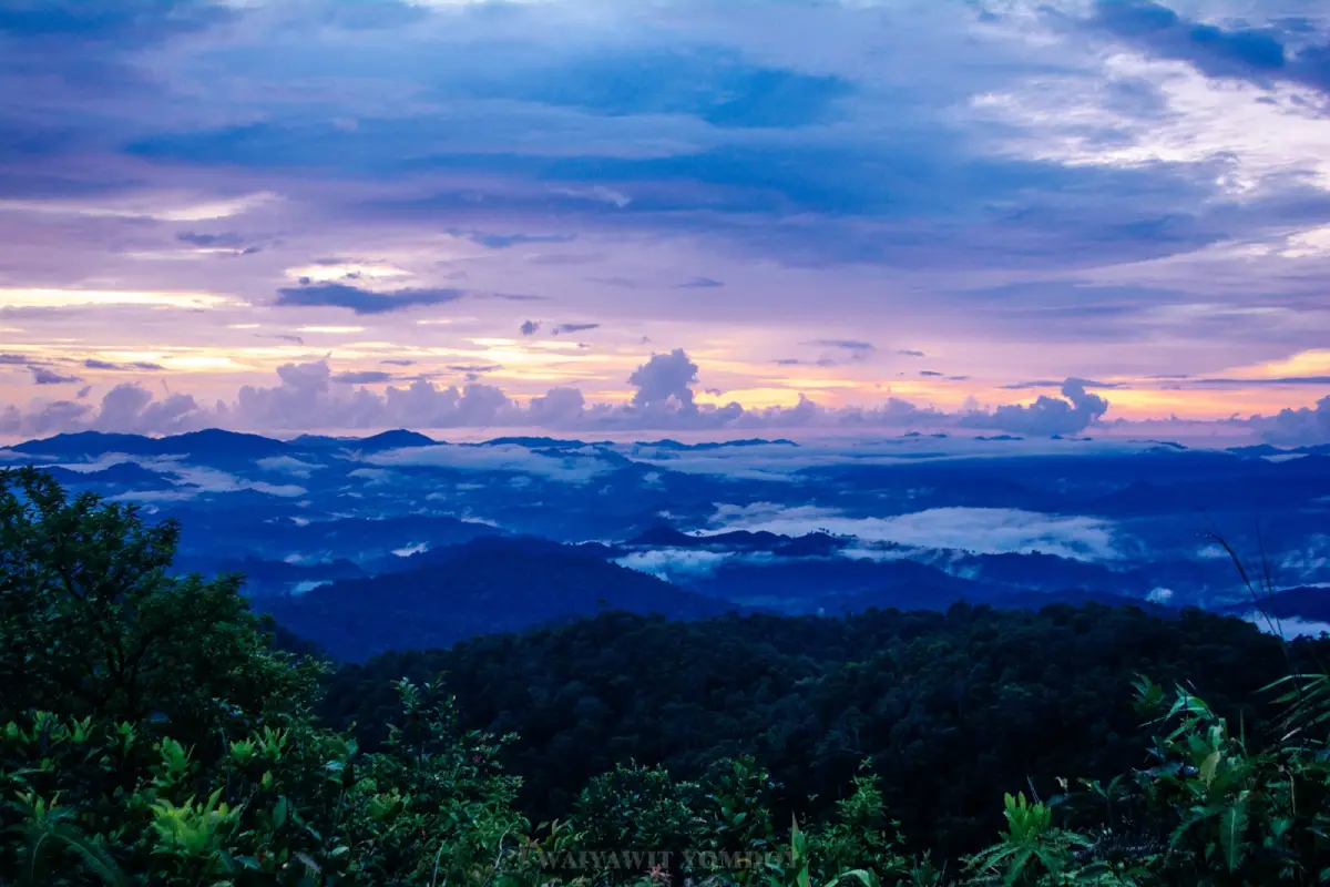
The main appeal of Phu Ta Jor is its wide panoramic viewpoint. From the summit area, visitors can see layered mountain ridges, deep green forest, and drifting morning mist. Under suitable weather conditions, the fog settles in the valleys and forms a white sea of mist beneath the viewpoint. The view can extend in all directions, giving Phu Ta Jor its reputation as a 360-degree viewpoint and one of the finest sea-of-mist destinations in southern Thailand.
The name Phu Ta Jor is linked with an old tin-mining area known as Mueang Ta Jor. Local stories describe Ta Jor, or Mr. Jor, as an early miner who opened the area. After the mining period ended, the upper mountain landscape was left to nature. Later, the local community and Le Subdistrict Administrative Organization recognized its tourism potential because of the sea of mist, mountain views, and unusual highland atmosphere. The area was then promoted as a nature and adventure destination with a camping ground, basic toilets, improved access sections, and local guides or 4WD drivers familiar with the route.
Phu Ta Jor sits in an ecologically important forest context. The surrounding area is linked with Ton Pariwat Wildlife Sanctuary, a protected wildlife area covering parts of Mueang Phang Nga, Kapong, and Thap Put districts. The forest also connects with the Khao Sok forest landscape. This wider region is important for biodiversity, watershed protection, and southern Thai rainforest ecosystems. A visit to Phu Ta Jor should therefore be treated as entering a sensitive conservation landscape, not merely a scenic lookout.
The atmosphere at Phu Ta Jor is unusually cool for a province commonly associated with the sea. During suitable periods, the temperature is often described as around 10–20 degrees Celsius, especially at night and in the early morning. The combination of high elevation, forest humidity, and valley terrain creates frequent mist conditions. Many visitors therefore choose to camp overnight rather than make a same-day visit, because the most impressive view usually appears before and shortly after sunrise.
Getting to Phu Ta Jor is part of the experience. From Ban Le, Ban Chang Chue, or nearby local communities, the road gradually changes from village road to forest track. The approach passes through Ban Chang Chue and Ban Nok Huk in Le Subdistrict before entering the rougher road toward the mountain. The route includes dirt, gravel, ruts, steep slopes, and sections affected by rain and erosion. A capable 4WD vehicle and an experienced local driver are strongly recommended.
The route includes several notable points. It starts from the Le area, passes Ban Chang Chue and Ban Nok Huk, then enters the forest road. Visitors pass a protection unit connected with Ton Pariwat Wildlife Sanctuary, the turn-off to Ton Ton Mak Waterfall, and an area known locally as Lan Malay, associated with old mining activity. The vehicle route ends near the upper camping area. From there, visitors walk around 10 minutes or roughly 200 meters to the viewpoint.
The camping ground is a wide open area near the upper part of the mountain. It is not a resort-style campsite with full services. The area has simple camping space, basic toilets, and limited water for general use. Visitors should bring drinking water, food, personal supplies, lighting, medication, waterproof bags, and rubbish bags. The campsite can be sunny during the day and windy at night, so strong tents and proper anchoring are important.
The summit viewpoint is the highlight. Before dawn, visitors walk from the camping ground to the viewpoint and wait as the sky changes from dark blue to violet, pink, and gold. When conditions are right, mist fills the valleys and the mountain ridges appear like islands above clouds. This is the image that gives Phu Ta Jor its reputation as a sea-of-mist destination in the south.
The mist is never exactly the same. It depends on humidity, rain, wind, temperature, and weather conditions from the previous day. Some mornings have thick mist covering the entire valley. Some days show thin layers drifting around the ridges. On other days the sky is clear and the view stretches far across the forest. This variability is part of the natural character of Phu Ta Jor, and visitors should treat the trip as a complete forest-and-mountain experience rather than expecting one fixed view.
On clear days, the viewpoint offers a deep and wide landscape. Visitors can see the Kapong forest, the Ton Pariwat forest area, mountain ridges connected with Khao Sok, and, in some directions, distant Andaman coastal views. At night, when the sky is open and light pollution is low, the campsite and viewpoint can also be suitable for stargazing. Phu Ta Jor therefore combines sunrise, sunset, mist, mountain views, and camping in one highland destination.
Ton Ton Mak Waterfall is a notable natural stop along the route. It lies in the forest landscape on the way to Phu Ta Jor and is commonly mentioned as being about 6 km from the Phu Ta Jor area. Reaching the waterfall involves a forest path of about 400–500 meters. It is often visited on the way down after the morning viewpoint experience. Visitors should be careful on wet paths, slippery stones, and humid forest sections, especially during or after rainfall.
Safety is essential. The road to Phu Ta Jor can be steep, muddy, rutted, and slippery, especially after rain. Standard cars are not suitable for the upper route. Travelers should use a local 4WD service and avoid attempting the forest road without experience. During heavy rain or unstable weather, travel should be postponed because the road condition can change quickly.
Overnight visitors should prepare for wind, rain, and cold air. A strong tent, sleeping bag, sleeping mat, windproof jacket, torch or headlamp, power bank, personal medicine, and waterproof storage are recommended. Even though Phang Nga is in southern Thailand, the high mountain environment can feel cold before sunrise. Good preparation makes the trip safer and more comfortable.
Waste management is critical. Phu Ta Jor is in a sensitive forest landscape with limited facilities. Visitors should carry all rubbish back down, avoid leaving food waste, avoid burning rubbish, and reduce disposable packaging before the trip. Responsible camping helps keep the viewpoint clean and protects the forest environment.
Visitor conduct should respect the protected forest. Avoid loud music, shouting, wildlife disturbance, off-trail exploration, cutting plants, feeding animals, or making fires in unsafe areas. The surrounding forest is part of a wildlife habitat, and quiet low-impact travel is the most appropriate approach.
Phu Ta Jor is best suited to adventure-minded travelers, nature photographers, campers, sea-of-mist seekers, and visitors who want to experience Phang Nga beyond beaches and islands. It may not be suitable for travelers who require high comfort, those uncomfortable with rough 4WD roads, people with mobility limitations, or families with very young children unless they are well prepared and travel with experienced local support.
The most suitable season depends on both visibility and road condition. The late rainy season to cool season often provides good mist conditions, while the period after rainfall can also create dramatic fog. However, heavy continuous rain should be avoided because the route may become slippery and unsafe. Visitors should always check local conditions before departure.
A good overnight plan is to arrive in Le Subdistrict in the afternoon, meet the local 4WD driver, travel up to the camping area in the late afternoon, set up camp, watch sunset, sleep overnight, wake before dawn, and walk to the viewpoint for sunrise and mist. After returning from the viewpoint, travelers can descend and visit Ton Ton Mak Waterfall, Plai Phu Hot Spring, cafes, or restaurants in Kapong.
A same-day trip is possible only with careful planning. Visitors must start very early, arrange the vehicle in advance, and allow enough time for the 4WD ascent and short walk to the viewpoint. Travelers coming from Phuket, Khao Lak, or Phang Nga town may find it more practical to stay in Kapong or Takua Pa the night before.
Getting There starts from Kapong District. Use the Kapong-Takua Pa route via Pak Phu-Oi Dam Road for about 11 km, then enter through Ban Chang Chue and Ban Nok Huk in Moo 1, Le Subdistrict. From there, continue by local 4WD along the forest road to Phu Ta Jor. Travelers from Phuket or Phang Nga town should first reach Kapong, then coordinate with local drivers in Le Subdistrict or Ban Chang Chue.
Travelers from Takua Pa can combine Phu Ta Jor with old Takua Pa, Kapong, Wat Narayanikaram, and local nature sites in one broader cultural and nature route. Those staying in Khao Lak can travel inland toward Kapong and overnight before the sunrise trip. A private car is useful for reaching the local meeting point, but the mountain ascent should be handled by experienced 4WD drivers.
Phu Ta Jor connects well with other Kapong attractions. After the mist-viewing experience, visitors can continue to Plai Phu Hot Spring, Kapong Canyon, old Kapong market areas, Wat Narayanikaram, and local restaurants. This makes Kapong a complete inland destination with mountains, mist, hot springs, archaeology, small-town life, and local food.
For photography, Phu Ta Jor is best captured with a wide angle that includes mist, ridges, and sunrise light. The light changes quickly before sunrise, so cameras should be ready early. Visitors should avoid standing near unstable edges, wet rocks, or steep slopes, and should respect other travelers sharing the viewpoint.
Useful items include warm clothing, windproof jacket, tent, sleeping bag, sleeping mat, headlamp, drinking water, food, personal medicine, leech protection during humid seasons, waterproof bags, sturdy footwear, rubbish bags, and power banks. Mobile signal may be unreliable in forest areas, so travelers should inform someone of their plan before departure.
In summary, Phu Ta Jor proves that Phang Nga is not only a province of sea and limestone islands. It is also a province of mountains, rainforest, mist, and adventure. Its value lies in the raw beauty of nature, 360-degree views, cool air, the old Mueang Ta Jor mining story, and the challenging journey into the forest. With proper preparation, a responsible local 4WD service, and low-impact travel behavior, Phu Ta Jor can be one of Phang Nga’s most memorable highland experiences.
| Name | Phu Ta Jor / Phu Ta Jor Sea Of Mist Viewpoint |
| Location | Moo 1, Le Subdistrict, Kapong District, Phang Nga Province |
| Coordinates | 8.68704, 98.52303 |
| Place Type | High mountain viewpoint in a protected forest landscape, suitable for sea of mist, sunrise, sunset, camping, 4WD travel, and nature photography |
| Approximate Elevation | About 1,300–1,350 metres above sea level according to travel and local tourism sources |
| Highlights | Morning sea of mist, 360-degree mountain view, cool air, camping ground, 4WD route, old Mueang Ta Jor mining landscape, rainforest, and Ton Ton Mak Waterfall on the route |
| Name Origin / History | Formerly an old tin-mining area called Mueang Ta Jor, named after Ta Jor, an early miner associated with the site |
| Related Conservation Area | Ton Pariwat Wildlife Sanctuary and forest connected with Khao Sok |
| Open Days | Daily, subject to local 4WD arrangement and weather conditions |
| Opening Hours | The viewpoint area is listed as open 24 hours; the best time to visit is before sunrise and in the early morning |
| Current Status | An active sea-of-mist and nature camping viewpoint in Kapong District, accessed by local 4WD service and weather-dependent forest road |
| Local Caretaker / Contact Body | Le Subdistrict Administrative Organization and Ton Pariwat Wildlife Sanctuary context for forest conservation |
| Le Subdistrict Administrative Organization Contact | 076-455-766 |
| Travel Information | Use the Kapong-Takua Pa route via Pak Phu-Oi Dam Road for about 11 km, enter through Ban Chang Chue and Ban Nok Huk in Moo 1, Le Subdistrict, then continue by local 4WD on the forest road to Phu Ta Jor |
| Main Areas / Route Points | Ban Chang Chue local 4WD meeting point, Ban Nok Huk route, forest protection unit, Ton Ton Mak Waterfall path, Lan Malay, camping ground, short walking trail, and 360-degree viewpoint |
| Recommended Activities | Sea-of-mist viewing, sunrise, sunset, camping, nature photography, 4WD travel, stargazing, short viewpoint walk, and Ton Ton Mak Waterfall stop |
| Facilities | Camping ground, basic toilets, limited water for general use, and upper parking area before the short walk to the viewpoint |
| Visitor Conduct | Use an experienced 4WD driver, bring drinking water and food, pack out all rubbish, stay on routes, avoid disturbing wildlife, keep noise low, and check weather before departure |
| Nearby Tourist Attractions | 1. Ton Ton Mak Waterfall, about 6 km 2. Plai Phu Hot Spring, about 7 km 3. Ton Pariwat Wildlife Sanctuary, about 9 km 4. Kapong Canyon / Ban Saphan Suea, about 10 km 5. Wat Narayanikaram / Khao Phra Narai, about 15 km 6. Old Kapong Market / Pak Thak Walking Street, about 13 km |
| Nearby Restaurants | 1. Kapong Ahan Restaurant, about 14 km, Tel. 076-499-666 2. Kesawalee Garden & Cafe, about 18 km, Tel. 064-051-7888 3. N PLAI WA, about 20 km, Tel. 065-552-9163 4. Kampong Restaurant, about 12 km, Tel. 099-352-1694 5. Restaurants And Cafes In Kapong Town, about 12–20 km |
| Nearby Accommodations | 1. Kapong Garden Resort, about 14 km, Tel. 076-499-666 2. Resort Kapong ATV, about 18 km, Tel. 081-737-7401 3. Mok Yam Chao Kapong Resort, about 23 km, Tel. 089-925-1754 4. Wassana Rimthara Resort, about 25 km, Tel. 082-840-9044 5. Yaowawit School, Lodge & Farm, about 25 km, Tel. 098-531-3722 |
Frequently Asked Questions (FAQ)
Q: Where is Phu Ta Jor located?
A: Phu Ta Jor is located in Moo 1, Le Subdistrict, Kapong District, Phang Nga Province, within the wider conservation landscape linked with Ton Pariwat Wildlife Sanctuary.
Q: What is Phu Ta Jor known for?
A: It is known for morning sea of mist, 360-degree mountain views, cool air, camping, rugged 4WD access, and rainforest scenery in Kapong District.
Q: What type of vehicle is needed?
A: A 4WD vehicle with an experienced local driver is strongly recommended because the route includes steep dirt roads, ruts, forest sections, and weather-sensitive terrain.
Q: Can visitors camp at Phu Ta Jor?
A: Yes. Visitors can camp at the upper camping ground, but they should bring proper camping gear, drinking water, food, lighting, wind protection, and rubbish bags.
Q: When is the best time to see the sea of mist?
A: The late rainy season through the cool season is generally favourable, and mist can also be beautiful after rainfall when the sky clears and the route is safe.
Q: Is Phu Ta Jor suitable for children or older travelers?
A: It can be suitable only when travelers are physically ready, use a safe local 4WD service, and understand that the route is rough and requires a short walk to the viewpoint.
Q: What nearby places can be combined with Phu Ta Jor?
A: Nearby places include Ton Ton Mak Waterfall, Plai Phu Hot Spring, Kapong Canyon, Wat Narayanikaram, old Kapong market areas, and local restaurants in Kapong District.
Q: What should visitors prepare?
A: Visitors should bring warm clothing, windproof jacket, tent, sleeping bag, drinking water, food, headlamp, medicine, waterproof bags, sturdy shoes, and rubbish bags.
 Category: ●Nature and Wildlife
 Group: ●Mountain (Doi)
Last Update : 2 MonthAgo
 Last Update : 2 MonthAgo

 Click to Access the Navigation Map GPS
Phu Ta Jor Map
Recommend

 Art, Culture and Heritage
 Historical Sites and Monuments(2)
 Landmarks and Memorials(6)
 Art, Craft Centres, Tradition(3)
 Places of Worship
 Temple(18)
 Other Sacred Sites(8)
 Suburban Living
 Village, Community(3)
 National Parks and Marine Reserves(12)
Mountain (Doi)(8)
 Waterfalls(21)
 Hot Springs(2)
 Caves(12)
 River, Canal(4)
 Bays and Beaches(28)
 Islands(11)
 Other natural attractions(7)
 Entertainment and Agricultural
 Animal camps and shows(2)
 Farms, Parks and Ecotourism(2)
 Waterpark(3)
 Outdoor and Adventure Activities(3)
 Travel Articles, Recipes
 Travel Review, Food Review(1)
 Southern Food Menu, Southern Food Recipes(1)


