
lovethailand home >South Travel Attractions >Phang Nga Travel Attractions >Takua Thung >Ka Lai > Tham Lot
TL;DR: Tham Lot is located at Around Ko Thalu, within Ao Phang Nga National Park, Phang Nga Province, open Daily, hours 08.00 - 16.30.

Tham Lot
Open Days: Daily
Opening Hours: 08.00 - 16.30
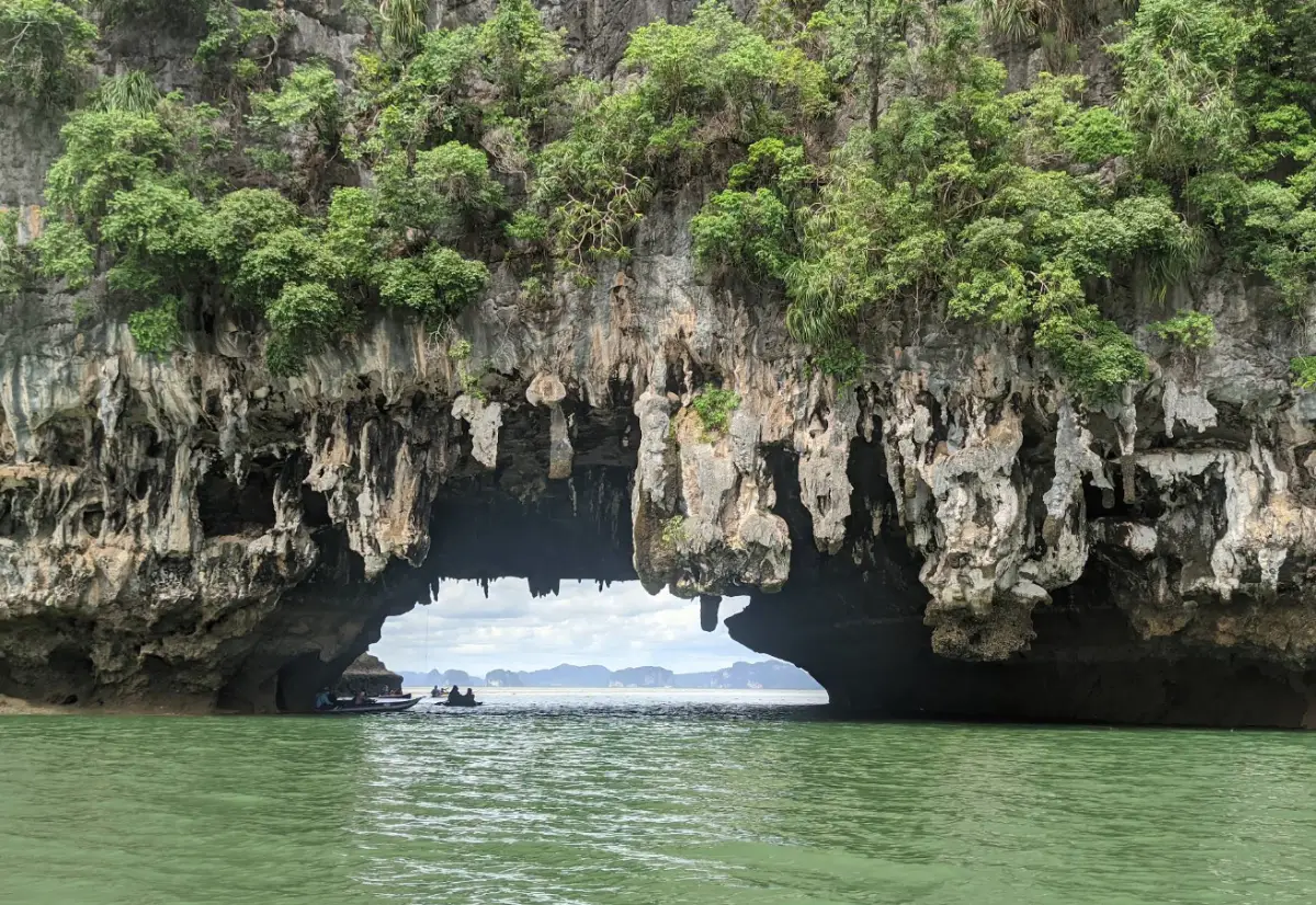
Tham Lot in Phang Nga Province is a sea cave and one of the notable natural attractions inside Ao Phang Nga National Park. It is located around Ko Thalu, within the famous coastal karst landscape of Phang Nga Bay. The cave is known for its natural tunnel-like passage that allows small boats or canoes to pass through, its limestone ceiling, stalactites, unusual rock textures, and the surrounding mangrove scenery. A visit to Tham Lot is not only about seeing a cave, but also about experiencing the combination of sea, limestone cliffs, tidal water, mangrove forest, and Phang Nga Bay’s iconic island scenery.
For a quick overview, Tham Lot is a boat-access sea cave in Ao Phang Nga National Park. It is suitable for travelers who want to see sea caves, limestone formations, mangrove ecosystems, long-tail boat routes, and canoeing scenery in one trip. The cave is usually included in Phang Nga Bay boat routes together with Ko Panyi, Khao Phing Kan, Ko Tapu, Khao Khian, Ko Hong, Ko Phanak, and the mangrove waterways of the national park. Visitors should plan the trip from Ao Phang Nga National Park headquarters at Ban Tha Dan, Ko Panyi Subdistrict, Mueang Phang Nga District, or from an approved pier used for Phang Nga Bay tours.
Tham Lot belongs to Ao Phang Nga National Park, a marine national park covering coastal areas, mangrove forests, and limestone islands in Mueang Phang Nga and Takua Thung Districts. The park covers about 250,000 rai and was declared a national park on April 29, 1981. Its importance lies not only in scenery, but also in geology, mangrove ecology, local coastal communities, and historical evidence such as the ancient paintings at Khao Khian.
The landscape of Phang Nga Bay is defined by limestone islands rising from emerald-green seawater. Each island has a different shape formed by erosion, dissolution, waves, wind, and rain over long periods. In some limestone formations, natural tunnels, caves, arches, and overhangs develop. Tham Lot is one of the clearest examples of this coastal karst process because the cave has a passage where seawater flows through and boats can pass from one side to another.
The Thai name “Tham Lot” directly describes the character of the place. It means a cave that can be passed through. Unlike land caves that are explored on foot, Tham Lot is experienced from the water. Visitors move through the limestone opening by boat or canoe, see daylight at both ends of the cave, look up at hanging formations on the ceiling, and feel the scale of the limestone mountain surrounding the water passage.
The original travel information describes Tham Lot as a large cave about 50 meters long, with boats able to pass through and beautiful stalactites and stalagmites inside. National park-related information also describes the cave as being on the southern side of Ko Thalu, about 50 meters long and around 20 meters wide on average. It is a sea cave with water flowing through to the other side, and it is popular for boat cruising and canoeing among the limestone scenery and nearby mangroves.
Inside the cave, visitors can see limestone walls and ceiling surfaces shaped by natural erosion. Some parts of the ceiling have hanging formations, while other surfaces show patterns caused by seawater, weathering, and long-term mineral activity. When the boat moves through the cave, sunlight from the openings reflects on the water and cave walls, creating changing light and shadow. This makes each visit slightly different depending on tide level, time of day, and weather.
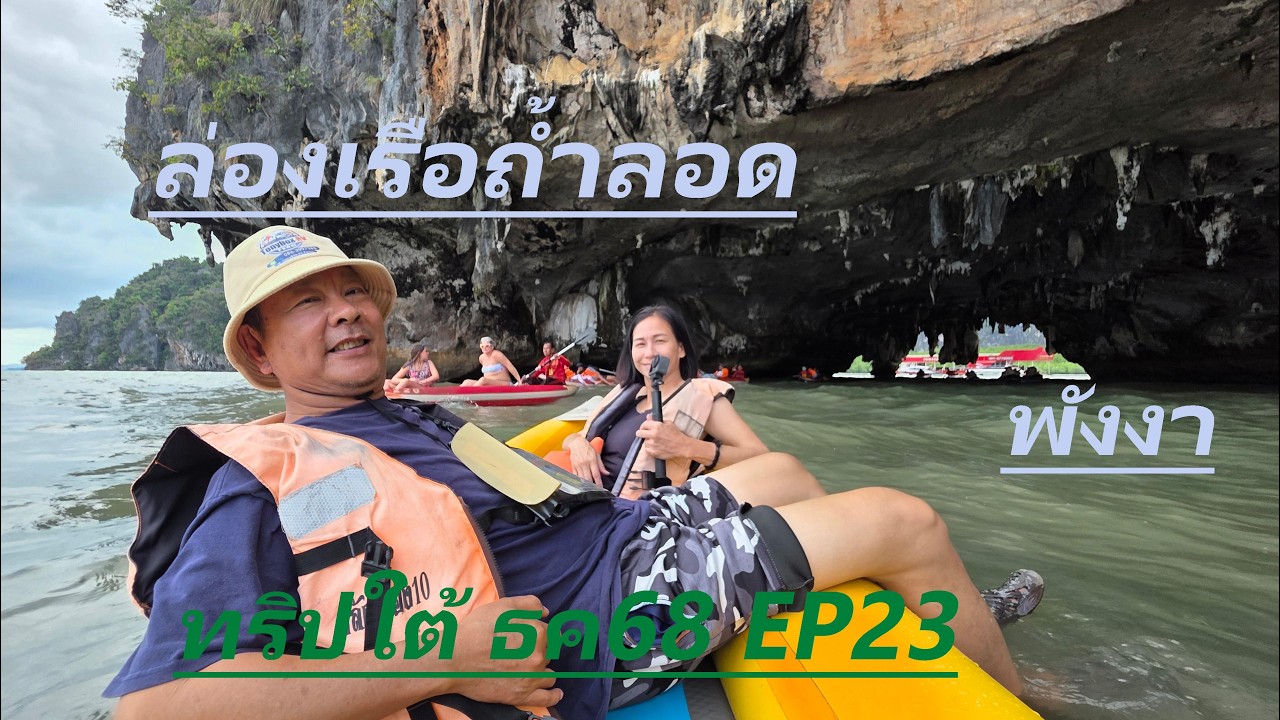
Tham Lot should be understood as a sea cave experience rather than a walking cave. Visitors usually do not walk deep into the cave. Instead, they view it from a long-tail boat, small boat, or canoe depending on the tour arrangement and tide conditions. Seeing the cave from water level gives a strong impression of the height of the ceiling, the width of the entrance, and the relationship between limestone cliffs and the sea.
The route to Tham Lot also passes through the mangrove landscape of Phang Nga Bay. Mangroves are essential coastal ecosystems because they protect shorelines, provide nursery areas for marine life, and support birds, fish, crabs, shellfish, and many other species. A trip to Tham Lot therefore includes both cave scenery and mangrove ecology, making it valuable for nature-focused travelers.
One important point is that access to the cave depends on tide level, sea conditions, and safety judgment by boat operators and park staff. Some times are suitable for passing through the cave or canoeing; other times may require viewing from outside or adjusting the route. Travelers should always follow instructions from the boat captain, guide, and national park staff.
The best general season for Phang Nga Bay is usually from late year to early year, when sea conditions are calmer. Travel is still possible on many days during the rainy season, but weather and waves should be checked in advance. For Tham Lot, safety is more important than strictly following a planned route. If conditions are not suitable, the boat program may be changed.
Tham Lot is commonly included in wider Phang Nga Bay boat itineraries. Popular companion stops include Ko Panyi, Khao Phing Kan, Ko Tapu, Khao Khian, Ko Hong, and Ko Phanak. This allows travelers to see sea caves, mangroves, a floating village, historical rock paintings, iconic limestone formations, and canoeing locations in a single trip.
Ko Panyi is one of the most meaningful nearby stops. It is a fishing village built over the water, known for seafood restaurants, stilt houses, a mosque, local shops, and the floating football pitch. Many Phang Nga Bay boat trips stop there for lunch. Combining Tham Lot with Ko Panyi gives travelers both natural scenery and a view of local life in the bay.
Khao Phing Kan and Ko Tapu are among the most famous landmarks of Phang Nga Bay. Khao Phing Kan is a pair of leaning limestone formations, while Ko Tapu is the slim rock tower widely known as James Bond Island. A route that includes Tham Lot, Khao Phing Kan, and Ko Tapu is ideal for first-time visitors who want the classic Phang Nga Bay experience.
Khao Khian adds a historical dimension to the bay route. It is known for ancient paintings on the cliff face, showing that Phang Nga Bay has long been used by people traveling, sheltering, and living along the Andaman coast. Including Khao Khian with Tham Lot gives the trip both geological and cultural depth.
Ko Hong and Ko Phanak extend the sea cave and canoeing experience. Ko Hong is known for hidden lagoon-like scenery surrounded by limestone walls, while Ko Phanak has caves and interior water features. Travelers who enjoy canoeing, caves, and limestone formations should allow enough time for these stops because they complement Tham Lot very well.
Getting There begins with traveling to Phang Nga Province. From Bangkok by car, follow Phet Kasem Road or Highway 4 for about 850 kilometers, taking roughly 11 hours. Once in Phang Nga, continue toward the Ao Phang Nga National Park headquarters and Ban Tha Dan pier via Highway 4144. This is one of the main starting points for boat trips to Tham Lot and other Phang Nga Bay attractions.
Travelers flying in can land at Phuket International Airport, then continue by car to Phang Nga. The driving distance to Phang Nga is about 61 kilometers and takes around 1 hour depending on traffic. Travelers staying in Phuket, Khao Lak, or Phang Nga town can also book a day tour that includes land transfer, boat service, meals, and canoeing. Those who prefer to start on the Phang Nga side may find it more convenient to stay in Phang Nga town.
Travelers using public buses can take a Bangkok-Phang Nga bus from the Southern Bus Terminal. After arriving at Phang Nga Bus Terminal, continue by local transport, songthaew, taxi, or arranged transfer to Ban Tha Dan pier. Train travelers can ride to Phunphin Station in Surat Thani Province, then continue by bus to Phang Nga, a distance of about 160 kilometers.
Boat access to Tham Lot can start from Ban Tha Dan pier in Mueang Phang Nga District, Surakul Pier in Takua Thung District, or other piers used by Phang Nga Bay operators. The best pier depends on accommodation, group size, and desired route. Travelers should agree on the itinerary before departure, especially if they want Tham Lot, Ko Panyi, Khao Phing Kan, Ko Tapu, Khao Khian, and canoeing included in the same program.
The national park entrance fee for Ao Phang Nga National Park is 100 baht for Thai adults, 50 baht for Thai children, 500 baht for foreign adults, and 300 baht for foreign children. Boat fees, canoe fees, and tour package prices depend on the pier, operator, number of passengers, and chosen program. Travelers should confirm the current boat price directly with the park office or tour operator before traveling.
Useful items for a Tham Lot trip include light clothing, hat, sunglasses, sunscreen, waterproof bag, rain jacket during the rainy season, and safe footwear for boarding boats. If canoeing is included, wear clothing that can get wet and keep valuables protected. Travelers who are prone to motion sickness should prepare accordingly before boarding the boat.
Responsible travel is essential. Wear a life jacket while on the boat or canoe, do not touch cave walls or limestone formations, do not break stalactites or stalagmites, do not throw rubbish into the sea, do not feed wildlife, and do not force entry into the cave when tide or wave conditions are unsafe. Tham Lot is beautiful but fragile, and the surrounding mangrove ecosystem must be protected.
Tham Lot is suitable for families, couples, groups of friends, photographers, students, and travelers interested in coastal geology. However, it may not suit visitors who are uncomfortable on boats, afraid of confined cave spaces, or unable to board small boats safely. Families with children and elderly travelers should choose calm-weather days and follow the guide’s instructions closely.
The cave is very photogenic. Strong images often include the boat near the cave entrance, light coming through the far opening, canoes passing under limestone ceilings, reflections on the water, and mangrove scenery along the route. Safety should come before photography. Avoid standing suddenly in the boat or leaning too far over the side to take photos.
Food can be arranged either as part of a tour package, on Ko Panyi, or back in Phang Nga town. Ko Panyi is well known for seafood restaurants and group lunch stops, while Phang Nga town has cafés, local restaurants, and family dining options. Travelers booking a boat package should check whether lunch is included.
For accommodation, staying in Phang Nga town is practical because it is close to the national park headquarters and Ban Tha Dan pier. Visitors can take a morning boat trip, return in the afternoon, and continue to cafés or restaurants in town. Phang Nga town also makes it easy to visit Phung Chang Cave, Tham Ruesi Sawan, Wat Tham Ta Pan, Sa Nang Manora Forest Park, Samet Nangshe, or Khao Lak.
A half-day itinerary can include Tham Lot, Ko Panyi, Khao Phing Kan, and Ko Tapu, returning to the pier within a few hours. A full-day itinerary can add Ko Hong, Ko Phanak, Khao Khian, or canoeing activities. The full-day option is better for travelers who want to see Phang Nga Bay at a slower pace and take more photographs.
In summary, Tham Lot is one of the signature sea cave attractions of Ao Phang Nga National Park. Although the cave is about 50 meters long, the value of the trip lies in the whole route: mangrove forest, tidal waterways, limestone islands, cave openings, reflected light, boat travel, and nearby landmarks of Phang Nga Bay. With careful planning and responsible travel behavior, visitors can experience one of Phang Nga’s most memorable natural landscapes in a complete and meaningful way.
| Name | Tham Lot, Ao Phang Nga National Park |
| Location | Around Ko Thalu, within Ao Phang Nga National Park, Phang Nga Province |
| Contact Address / Starting Point | Ao Phang Nga National Park, 80 Moo 1, Ban Tha Dan, Tha Lan Road, Ko Panyi Subdistrict, Mueang Phang Nga District, Phang Nga 82000, Thailand |
| Park Headquarters / Main Pier Coordinates | 8.3065613, 98.4555569 |
| Highlights | Sea cave on Ko Thalu, boat-access passage, limestone ceiling, stalactites, mangrove scenery, and Phang Nga Bay boat route |
| History / Period | Located within Ao Phang Nga National Park, declared a national park on April 29, 1981, and part of the Andaman coastal karst landscape |
| Name Origin | The name means a cave that can be passed through, referring to the natural limestone tunnel where small boats can move from one side to the other |
| Distinctive Features | About 50 meters long and around 20 meters wide on average, with seawater passing through the cave and hanging limestone formations on the ceiling |
| Travel Information | Travel to Phang Nga Province via Highway 4, then continue along Highway 4144 to Ao Phang Nga National Park headquarters and Ban Tha Dan Pier. Continue by boat to Tham Lot and Phang Nga Bay attractions. |
| Current Status | Open as part of Ao Phang Nga National Park boat routes. Actual cave access depends on tide level, sea conditions, and boat operator safety assessment. |
| Open Days | Daily |
| Opening Hours | 08.00 - 16.30 |
| National Park Entrance Fee | Thai adult 100 baht, Thai child 50 baht, foreign adult 500 baht, foreign child 300 baht |
| Facilities | Visitor center, pier, tour boats, welfare shop, toilets, parking area, national park accommodation, and camping area |
| Main Areas / Zones | Ban Tha Dan Pier, mangrove route, Tham Lot, Ko Thalu, Ko Panyi, Khao Phing Kan, Ko Tapu, Khao Khian, Ko Hong, and Ko Phanak |
| Caretaker | Ao Phang Nga National Park, Department of National Parks, Wildlife and Plant Conservation |
| Main Contact Number | 076-481-188, 076-481-163 |
| Nearby Tourist Attractions | 1. Ko Thalu, about 0 km 2. Ko Panyi, about 3 km 3. Khao Phing Kan, about 4 km 4. Ko Tapu, about 4 km 5. Khao Khian, about 5 km 6. Ko Hong, about 6 km 7. Ko Phanak, about 8 km |
| Nearby Restaurants | 1. Koh Panyee Village Restaurant, about 3 km 2. Andaman Seafood, Ko Panyi, about 3 km 3. Hink Cafe, about 9 km, Tel. 095-041-4040 4. Raruen Phang Nga Cafe & Restaurant, about 11 km, Tel. 089-628-5444 5. Er-Gu Cafe, about 11 km, Tel. 081-084-4141 6. Phung Chang Kung Kratha Phang Nga, about 11 km, Tel. 084-628-0404 |
| Nearby Accommodations | 1. Ao Phang Nga National Park Accommodation, about 0 km, Tel. 076-481-188 2. The Sleep Phang-nga, about 9 km, Tel. 076-411-828 3. Home Phang-Nga Guest House, about 10 km, Tel. 081-958-5538 4. Pranee Home Phang-nga, about 10 km, Tel. 098-616-9090 5. Le Erawan Phang Nga Hotel, about 12 km 6. Phang Nga Origin Hotel, about 12 km |
Frequently Asked Questions (FAQ)
Q: Where is Tham Lot located?
A: Tham Lot is located around Ko Thalu inside Ao Phang Nga National Park, Phang Nga Province. Visitors must access it by tour boat or canoe on a Phang Nga Bay route.
Q: What is special about Tham Lot?
A: It is a sea cave that boats can pass through, with limestone ceilings, stalactites, reflected light, tidal water, and a route through the mangrove scenery of Phang Nga Bay.
Q: What are the opening hours of Tham Lot?
A: Ao Phang Nga National Park is open daily from 08.00 to 16.30. Actual access to Tham Lot depends on tide level and sea conditions on the travel day.
Q: How much is the national park entrance fee?
A: The entrance fee is 100 baht for Thai adults, 50 baht for Thai children, 500 baht for foreign adults, and 300 baht for foreign children.
Q: Which pier should visitors use for Tham Lot?
A: Visitors can start from Ban Tha Dan Pier or other Phang Nga Bay tour piers such as Surakul Pier. The route should be agreed with the boat operator before departure.
Q: What should visitors prepare for a Tham Lot trip?
A: Bring light clothing, waterproof bag, hat, sunglasses, sunscreen, rain jacket, and safe footwear. Always wear a life jacket on boats and canoes.
Q: Is Tham Lot suitable for children and elderly travelers?
A: It is suitable for visitors who can board and sit safely on boats. Children and elderly travelers should be closely supervised and should travel on calm-weather days.
Q: What nearby attractions can be visited with Tham Lot?
A: Nearby attractions include Ko Panyi, Khao Phing Kan, Ko Tapu, Khao Khian, Ko Hong, Ko Phanak, and the mangrove routes of Ao Phang Nga National Park.
 Category: ●Nature and Wildlife
 Group: ●Caves
Last Update : 2 MonthAgo
 Last Update : 2 MonthAgo
 Click to Access the Navigation Map GPS

 Art, Culture and Heritage
 Historical Sites and Monuments(2)
 Landmarks and Memorials(6)
 Art, Craft Centres, Tradition(3)
 Places of Worship
 Temple(18)
 Other Sacred Sites(8)
 Suburban Living
 Village, Community(3)
 National Parks and Marine Reserves(12)
 Mountain (Doi)(8)
 Waterfalls(21)
 Hot Springs(2)
Caves(12)
 River, Canal(4)
 Bays and Beaches(28)
 Islands(11)
 Other natural attractions(7)
 Entertainment and Agricultural
 Animal camps and shows(2)
 Farms, Parks and Ecotourism(2)
 Waterpark(3)
 Outdoor and Adventure Activities(3)
 Travel Articles, Recipes
 Travel Review, Food Review(1)
 Southern Food Menu, Southern Food Recipes(1)


