
lovethailand home >South Travel Attractions >Nakhon Si Thammarat Travel Attractions >Pak Phanang >Hu Long > Utokvibha Prasit Floodgate
TL;DR: Utokvibha Prasit Floodgate is located at Hu Long Subdistrict, Pak Phanang District, Nakhon Si Thammarat Province, open Daily, hours 08.00 – 17.00.

Utokvibha Prasit Floodgate

Open Days: Daily
Opening Hours: 08.00 – 17.00
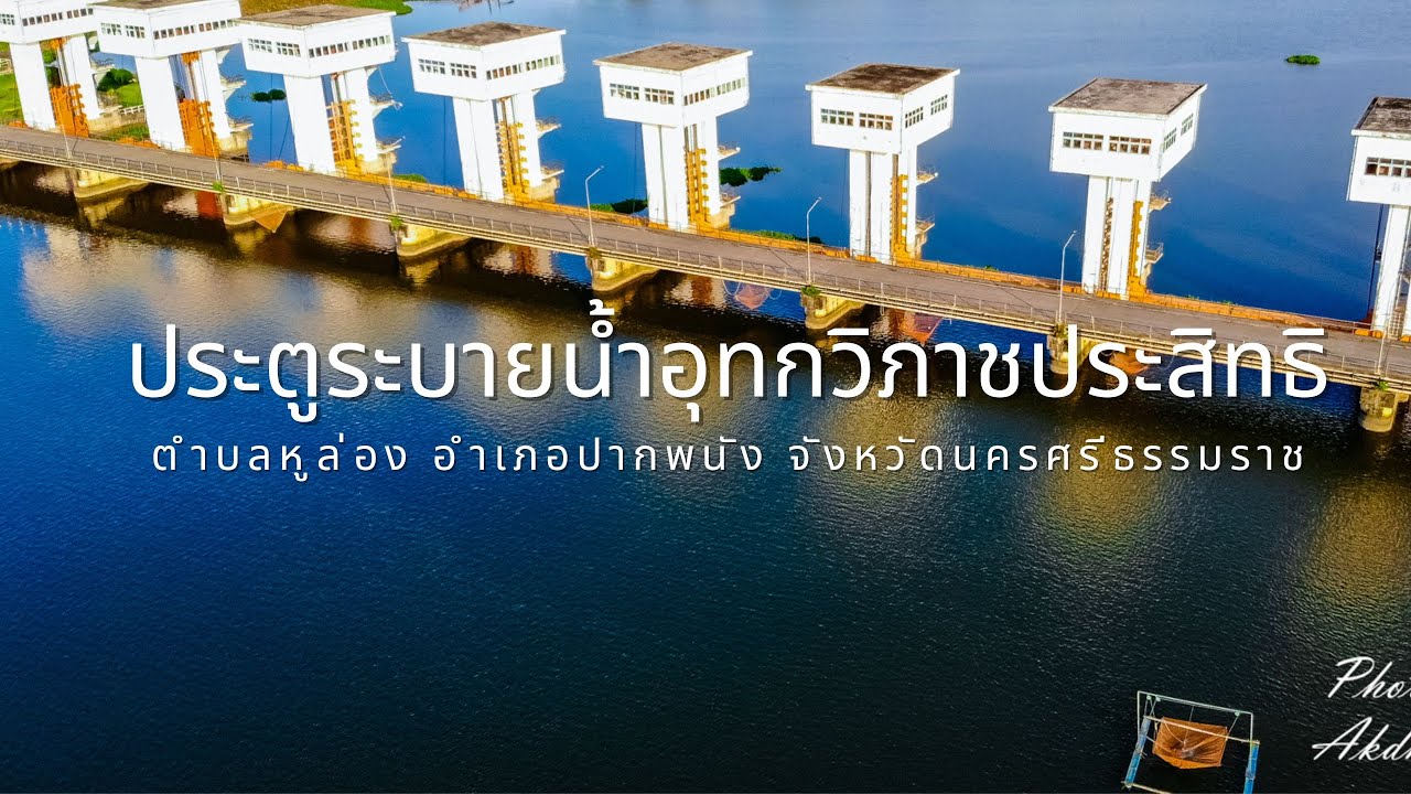
Utokvibha Prasit Floodgate in Nakhon Si Thammarat Province is located in Hu Long Subdistrict, Pak Phanang District, on the Pak Phanang River. It is one of the most important water-management landmarks in southern Thailand and serves as the central structure of the Pak Phanang Basin Development Project under the royal initiative of King Bhumibol Adulyadej, Rama IX. This floodgate is not only an irrigation structure but also a meaningful riverside landmark where visitors can understand how freshwater, saltwater, agriculture, fisheries, flood control, and local community life are managed within one connected basin.
The name “Utokvibha Prasit” is a royal name with a highly meaningful definition. It refers to the successful ability to separate freshwater from saltwater. This meaning directly reflects the main function of the floodgate, which is to prevent seawater from intruding too far into the Pak Phanang River, store freshwater upstream for household and agricultural use, and release water toward Pak Phanang Bay when water levels rise during the rainy season. The floodgate therefore represents a practical balance between freshwater storage, saltwater control, flood drainage, and environmental protection.
The Pak Phanang Basin is a lowland area strongly influenced by both river water and seawater from the Gulf of Thailand. For many years, the basin faced repeated problems, including freshwater shortages during the dry season, saltwater intrusion into agricultural areas, flooding during the rainy season, and pressure on natural resources. Because the area depends on rice fields, orchards, fisheries, canals, rivers, and coastal ecosystems, solving its water problems required a structure capable of managing the movement of water across the whole basin. Utokvibha Prasit Floodgate became the key structure that made this basin-wide water management possible.
King Bhumibol Adulyadej gave royal initiatives for the development of the Pak Phanang Basin on several occasions. The goal was to improve water management, reduce hardship caused by flooding and drought, prevent saltwater intrusion, and raise the quality of life for people living in the basin. Once the main floodgate was built, the wider system of canals, regulators, drainage routes, and irrigation management could be developed more effectively. This is why the floodgate is often considered the starting point of the modern Pak Phanang Basin water-management system.
The floodgate began operating on 1 October 1999. It has 10 large gate openings and is designed to control the flow of water between the upstream freshwater area and the downstream brackish or saltwater zone. It can store a large volume of freshwater upstream and release water during periods of heavy rainfall or high river flow. The structure combines hydraulic engineering, monitoring technology, and local participation, because decisions about opening or closing the gates must consider water levels, salinity, rainfall, tides, farmland, fisheries, riverbank communities, and the wider environment.
During the dry season, the floodgate helps retain freshwater upstream and prevents seawater from moving inland. This stored freshwater supports farming, household use, and local ecosystems. During the rainy season, the gates can be opened to drain excess water from upstream areas into Pak Phanang Bay, helping reduce flood risk in agricultural land and settlements. The same structure therefore performs several essential roles at once: storing freshwater, blocking saltwater, draining floodwater, and supporting the long-term stability of the basin.
For visitors, Utokvibha Prasit Floodgate is one of the best places to understand Pak Phanang through water. The large floodgate structure stretches across the river, with gate-control buildings, a riverside public area, viewpoints, and a broad view of the Pak Phanang River. From the floodgate area, visitors can see both the upstream and downstream sides of the river, making it easier to understand how the structure separates and manages different water conditions. The place is suitable for walking, photography, riverside relaxation, and learning about royal development work in southern Thailand.
The most attractive times to visit are in the morning and late afternoon. In the morning, the air is usually more comfortable and the river surface can appear calm. In the late afternoon, softer light creates a good atmosphere for photography, especially when the floodgate structure, river, and local boats appear in the same frame. The surrounding public space makes the site accessible for short visits, but visitors should always stay in safe public areas because the floodgate remains an active water-control structure.
The floodgate is also a good starting point for a wider Pak Phanang travel route. After visiting the floodgate, travelers can continue to Pak Phanang Old Market to experience riverside community life, traditional shops, local food, and the old commercial atmosphere of the district. Another nearby route leads to Ban Wong Bia Sat, an eco-tourism community by the river, or farther to Laem Talumphuk, a coastal cape known for fishing communities, sea views, and the history of the major storm that affected the area in 1962. This makes the floodgate a useful first stop for understanding both inland water management and coastal life.
Pak Phanang Old Market adds cultural depth to a trip because it reflects the district’s long relationship with the river. Local food, old riverside buildings, dried seafood, and community products help visitors see that Pak Phanang is not only an irrigation area but also an old water-based town. When combined with the floodgate, the route shows how water management supports everyday life, trade, agriculture, and local identity.
Laem Talumphuk gives the route a coastal dimension. Located near the mouth of the Pak Phanang River, it shows the meeting point between river water and seawater. The area has beaches, fishing communities, coastal scenery, and historical memory connected with severe storm damage in the past. Visiting both the floodgate and Laem Talumphuk helps travelers understand why separating freshwater from saltwater is so important for this district.
Visitors should behave carefully and respectfully at Utokvibha Prasit Floodgate. The site is a real water-control facility, not only a scenic viewpoint. Visitors should not enter operational zones, climb railings or structures, stand too close to strong-current areas, throw rubbish into the river, or block local traffic on the floodgate road. Families with children should supervise them closely near the riverside and bridge areas. During the rainy season or periods of high water discharge, visitors should follow local warnings and avoid unsafe areas near fast-flowing water.
Getting There is easiest by private car or rental car. From Nakhon Si Thammarat city, travel toward Pak Phanang District, then continue to Hu Long Subdistrict and Ban Bang Pi, where the floodgate is located. The route is suitable for a one-day trip, especially when combined with Pak Phanang Old Market, Ban Wong Bia Sat, and Laem Talumphuk. Daytime travel is recommended because it allows visitors to see the river, public areas, and nearby attractions clearly.
Overall, Utokvibha Prasit Floodgate is one of the most meaningful places to visit in Pak Phanang. It combines royal development, engineering, water management, agriculture, fisheries, community life, and environmental balance in one location. Visitors who understand its role will see more than a large floodgate across a river. They will see the central mechanism that helps Pak Phanang live with freshwater and saltwater in a more balanced and sustainable way.
| Name | Utokvibha Prasit Floodgate / Pak Phanang Floodgate |
| Location | Hu Long Subdistrict, Pak Phanang District, Nakhon Si Thammarat Province |
| Address | Ban Bang Pi, Hu Long Subdistrict, Pak Phanang District, Nakhon Si Thammarat 80140, Thailand |
| Type | Floodgate, Royal Development Water Project, Pak Phanang River Viewpoint, Public Park, And Water-Management Learning Site |
| Name Meaning | Utokvibha Prasit Means The Successful Ability To Separate Freshwater From Saltwater |
| Importance | A Key Structure Of The Pak Phanang Basin Development Project, Created To Control Saltwater Intrusion, Store Freshwater, Drain Floodwater, And Improve Local Quality Of Life |
| Project Characteristics | Large Floodgate With 10 Gate Openings, Used To Manage Water Flow Between The Upstream Freshwater Zone And The Downstream Brackish Or Saltwater Zone |
| Main Functions | Prevents Saltwater Intrusion, Stores Freshwater For The Dry Season, Releases Excess Water During The Rainy Season, And Supports Basin-Wide Water Management |
| Highlights | Large Floodgate Structure, Pak Phanang River View, Royal-Name Memorial Area, Riverside Public Space, Gate-Crest Road, And Freshwater-Saltwater Management Role |
| Current Status | Still Operating As A Major Water-Control Structure And Open As A Public Viewpoint And Local Recreation Area |
| Open Days | Daily |
| Opening Hours | 08.00 – 17.00 |
| Caretaker / Related Offices | Royal Irrigation Department / Irrigation Office 15 / Lower Pak Phanang Operation And Maintenance Project / Local Water-Management Committee |
| Contact Number | Irrigation Office 15 Tel. 0-7544-3150 |
| Main Areas / Zones | Royal-Name Memorial Area, Floodgate Crest, 10 Gate-Control Structures, Pak Phanang River Viewpoints, Riverside Public Park, Upstream Water Zone, Downstream Water Zone, And Local Bridge Connection |
| Travel Information | Travel From Nakhon Si Thammarat City To Pak Phanang District, Then Continue To Hu Long Subdistrict And Ban Bang Pi. A Private Car Or Rental Car Is Recommended. |
| Nearby Tourist Attractions | 1. Utokvibha Prasit Floodgate Viewpoint, About 0 km 2. Ban Wong Bia Sat Pak Phanang, About 5 km 3. Pak Phanang Old Market, About 8 km 4. Pak Phanang Riverside And Bang Wa Bridge Area, About 8 km 5. Wat Laem Talumphuk, About 18 km 6. Laem Talumphuk, About 20 km 7. Pak Phanang Fang Tawan Tok Fishing Community Route, About 5 km |
| Nearby Restaurants | 1. Ban Chaiklong Pak Phanang, About 8 km, Tel. 075-333-831 2. Cafe De Porto, About 8 km, Tel. 081-893-4842 3. Khanom Yim Seafood, About 15 km, Tel. 082-804-6112 4. Ban Ko Ood Seafood, About 15 km, Tel. 084-861-1025 5. Krua Kamnan, About 18 km, Tel. 081-535-2882, 081-958-2099 6. Chao Lay Homestay @ Pak Phanang, About 5 km, Tel. 075-518-789, 080-596-8189 |
| Nearby Accommodations | 1. Chao Lay Homestay @ Pak Phanang, About 5 km, Tel. 075-518-789, 080-596-8189 2. Ban Wong Bia Sat Eco Stay, About 5 km, Tel. 065-409-8256 3. Olivia Resort Pak Phanang Fang Tawan Tok, About 8 km, Tel. 064-167-4877, 075-370-869 4. Pak Phanang Hotel / Khrua Mueang Nang Seafood, About 8 km, Tel. 075-517-016 5. Khong Wilai Resort, About 9 km, Tel. 075-370-442 6. Accommodation In Nakhon Si Thammarat City, About 35 km |
Frequently Asked Questions (FAQ)
Q: Where Is Utokvibha Prasit Floodgate Located?
A: Utokvibha Prasit Floodgate Is Located In Hu Long Subdistrict, Pak Phanang District, Nakhon Si Thammarat Province, Around Ban Bang Pi On The Pak Phanang River.
Q: What Does The Name Utokvibha Prasit Mean?
A: The Name Means The Successful Ability To Separate Freshwater From Saltwater, Reflecting The Floodgate’s Main Function In Managing The Pak Phanang River System.
Q: What Are The Opening Hours?
A: The Site Is Open Daily From 08.00 To 17.00. Morning And Late Afternoon Are The Best Times For Walking, Viewing The River, And Photography.
Q: Why Is Utokvibha Prasit Floodgate Important To Pak Phanang?
A: It Is The Main Water-Control Structure Of The Pak Phanang Basin, Helping Prevent Saltwater Intrusion, Store Freshwater, Drain Floodwater, Support Agriculture, And Improve Local Quality Of Life.
Q: How Many Gate Openings Does The Floodgate Have?
A: The Floodgate Has 10 Gate Openings, Used To Control Water Flow Between The Upstream Freshwater Zone And The Downstream Brackish Or Saltwater Zone.
Q: What Nearby Places Can Be Combined With A Visit?
A: Nearby Places Include Pak Phanang Old Market, Ban Wong Bia Sat, Pak Phanang Riverside, Wat Laem Talumphuk, And Laem Talumphuk.
Q: What Should Visitors Be Careful About?
A: Visitors Should Avoid Operational Areas, Strong-Current Zones, Gate Structures, Bridge Edges, And Any Restricted Areas. Families Should Supervise Children Closely Near The River.
Q: How Can Travelers Get There?
A: Travel By Private Car Or Rental Car From Nakhon Si Thammarat City To Pak Phanang District, Then Continue To Hu Long Subdistrict And Ban Bang Pi.
 Category: ●Nature and Wildlife
 Group: ●Dam, Reservoir, Lake
Last Update : 2 MonthAgo
 Last Update : 2 MonthAgo
 Click to Access the Navigation Map GPS
Utokvibha Prasit Floodgate Map
Recommend

 Art, Culture and Heritage
 Historical Sites and Monuments(9)
 Landmarks and Memorials(9)
 Royal Palace(1)
 Art, Craft Centres, Tradition(12)
 Museums(5)
 Educational Places
 Educational Gardens, Farm(2)
 Places of Worship
 Temple(44)
 Mosque(2)
 Other Sacred Sites(17)
 Research and Development
 Royal Project(2)
 Suburban Living
 Village, Community(8)
 Local Market(1)
 Floating Market(1)
 National Parks and Marine Reserves(6)
 Mountain (Doi)(11)
Dam, Reservoir, Lake(10)
 Waterfalls(43)
 Hot Springs(1)
 Caves(13)
 River, Canal(3)
 Bays and Beaches(29)
 Islands(2)
 Other natural attractions(3)
 Entertainment and Agricultural
 Farms, Parks and Ecotourism(3)
 Outdoor and Adventure Activities(4)
 Travel Articles, Recipes
 Travel Review, Food Review(5)
 Southern Food Menu, Southern Food Recipes(18)


