
lovethailand home >South Travel Attractions >Nakhon Si Thammarat Travel Attractions >Si Chon >Si Khit > Si Khit Waterfall
TL;DR: Si Khit Waterfall is located at Village No. 2, Si Khit Subdistrict, Sichon District, Nakhon Si Thammarat Province, open Daily, Except During The National Park’s Seasonal Tourism And Overnight-Stay, hours 08.30 – 16.30.

Si Khit Waterfall
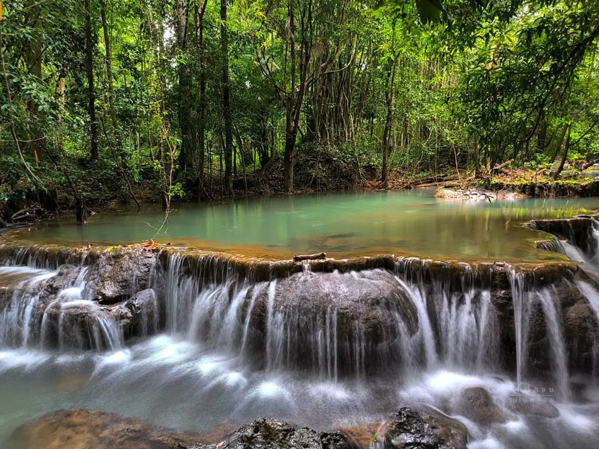
Open Days: Daily, Except During The National Park’s Seasonal Tourism And Overnight-Stay Closure From 25 October – 25 December 2026
Opening Hours: 08.30 – 16.30
Si Khit Waterfall in Nakhon Si Thammarat is the main highlight of Namtok Si Khit National Park. It is located around Khlong Tha Khok in Village No. 2, Si Khit Subdistrict, Sichon District, Nakhon Si Thammarat Province. The national park covers parts of Sichon District in Nakhon Si Thammarat and Kanchanadit District in Surat Thani. It was declared a national park on 17 June 1999, with an area of about 90,625 rai, or roughly 145 square kilometers. The highest peak is Khao Khi Mot, rising to about 1,303 meters above sea level.
Si Khit Waterfall is a limestone waterfall known for emerald-green water, broad natural pools, and a long stream that flows across limestone formations. The first upper section of the waterfall begins from a cliff about 60 meters high, before the stream continues across rock terraces for about 12 kilometers. The waterfall area includes pools, rock formations, stream channels, forest shade, and several scenic places suitable for safe water play, photography, and nature relaxation.
The distinctive character of Si Khit Waterfall comes from limestone. In many sections, algae do not cling to the limestone surface as much as they do on ordinary waterfall rocks, making some areas less slippery. Even so, the waterfall remains a natural stream environment, and visitors must still be cautious. Wet rocks, stream channels, deeper pools, and changing water levels can still be dangerous, especially after rainfall in the mountains.
The name “Si Khit” is connected with local history and landscape. Local accounts describe the old forest as dense, full of wildlife, and difficult to travel through. The reddish soil and intersecting routes in the area created four visible marks or tracks, which later became associated with the name Ban Si Khit and the waterfall itself. The name therefore reflects not only the waterfall, but also the memory of local travel, forest settlement, and community identity.
The national park is covered mainly by moist evergreen forest. Important plants include dipterocarp-family trees, takhian thong, lumpho, and wild champak, along with ferns, mosses, streamside vegetation, and dense forest undergrowth. The forest is also home to wildlife such as tapirs, serows, and rare southern resident birds. This makes Si Khit Waterfall more than a place for swimming; it is also a valuable natural learning site for rainforest ecology in upper Nakhon Si Thammarat.
The climate is relatively cool and humid because the park lies in a high mountain range with dense forest cover. Rain is especially frequent around November, when the waterfall often has a stronger flow and the forest is at its greenest. However, this is also the period when visitors should pay close attention to water level, slippery ground, and park announcements. In 2026, Si Khit Waterfall, Dong Waterfall, and Suan Prang Cave have a seasonal tourism and overnight-stay closure from 25 October to 25 December.
Several natural attractions can be visited within the national park. Khao Phap Pha Cave is a small limestone cave about 5 kilometers from the park headquarters. It contains beautiful stalactites and stalagmites and is about 50 to 60 meters deep from the cave entrance. Visitors should enter with park staff. Suan Prang Cave is a large limestone cave near Ranger Unit SK.1, known for wide chambers and curtain-like cave formations. It is sometimes described as a “bat palace” because many bats live inside.
Phurin Waterfall is about 2 kilometers from Suan Prang Cave. It is formed by a stream flowing through limestone mountain and cave terrain, and fish can be seen in the stream. Kho Ram Cave is another limestone cave with a wide entrance on a steep cliff near Ranger Unit SK.1. The cave entrance offers a view over the forest below, and the area is connected with serows, known locally as “kho ram.” Another nearby waterfall, No Tong Waterfall in Sichon District, is a 7-tier waterfall hidden in the forest.
Main activities at Si Khit Waterfall include resting by the stream, swimming in safe pools, photographing the emerald water and limestone terraces, walking short nature trails, and learning about forest ecology. The park also has short nature trails and longer trekking routes. Visitors who want to enter forest routes, caves, or more remote sections should contact the visitor center and use a park guide when required.
Facilities in the park include a visitor service area, welfare shop, camping areas, and resting areas near the water. Camping is available around the park headquarters, Ranger Unit SK.1 at Suan Prang, and the Phurin Waterfall area when park services are open. Visitors planning to stay overnight should contact the park before traveling, especially because overnight stays are not available during the seasonal closure period.
The national park entrance fee for Namtok Si Khit National Park is in the Group 1 rate. Thai visitors pay 20 baht for adults and 10 baht for children. Foreign visitors pay 100 baht for adults and 50 baht for children. Vehicle fees may apply according to current national park regulations. Cash preparation is recommended, and visitors should check the latest announcement before traveling during the rainy season.
Travel from Nakhon Si Thammarat city follows Highway 401 toward Sichon for about 69 kilometers to Sichon intersection, also known locally around Ton Phayom intersection, then turns left for about 15 kilometers to the national park. From Surat Thani city, take Highway 401 for about 52 kilometers to Khao Hua Chang junction, then turn right for about 10 kilometers. The park is most convenient by private car, and the road access is generally suitable for regular vehicles.
The reference coordinates for Namtok Si Khit National Park are 9.014203, 99.771735. These coordinates are useful for navigation to the main park area, but visitors should still follow local signs and park staff guidance because the park includes multiple areas such as waterfalls, caves, ranger units, nature trails, and camping sites. Cave visits and some nature routes require staff guidance.
Si Khit Waterfall is suitable for families, nature travelers, photographers, and visitors who want a refreshing waterfall experience without going deep into remote forest. Families can enjoy broad pools and shaded streamside areas where conditions are safe. Photographers will find limestone terraces, emerald water, rainforest, and layered cascades. More active travelers can add cave visits, short trails, or camping to the trip.
Safety is important. Although limestone surfaces may be less slippery in some areas, wet rocks can still cause accidents. Visitors should not run on rocks, jump into unknown pools, climb wet terraces, or enter strong current. If the water becomes muddy, rainfall intensifies, or stream noise changes suddenly, visitors should leave the water and move to a safer area. Cave visits should be avoided during heavy rain and should be made only with park guidance.
Useful items include non-slip footwear, spare clothes, a towel, waterproof bags for phones or cameras, drinking water, personal medication, and a waste bag. Visitors should not use soap or shampoo in the stream, leave food waste, feed wildlife, or damage plants. Si Khit Waterfall is part of an important watershed forest, and responsible behavior helps preserve the clear water, limestone formations, forest, and wildlife.
A complete trip can combine Si Khit Waterfall with Khao Phap Pha Cave, Suan Prang Cave, Phurin Waterfall, Kho Ram Cave, No Tong Waterfall, and Sichon Beach. Travelers from Surat Thani can enter via Kanchanadit, while travelers from Nakhon Si Thammarat can use Sichon as the main route. This makes the national park a useful connection point between inland rainforest and coastal Sichon.
In summary, Si Khit Waterfall is one of the most distinctive natural attractions in Sichon District and Namtok Si Khit National Park. It combines limestone cascades, emerald-green pools, moist evergreen forest, wildlife habitat, caves, camping areas, and nature trails. With current park-status checks, safe weather, and proper preparation, the waterfall offers one of the most complete inland nature experiences in upper Nakhon Si Thammarat.
Getting There from Nakhon Si Thammarat city: take Highway 401 toward Sichon for about 69 kilometers to Sichon intersection or Ton Phayom intersection, then turn left for about 15 kilometers to Namtok Si Khit National Park. From Surat Thani city, take Highway 401 for about 52 kilometers to Khao Hua Chang junction, then turn right for about 10 kilometers. Use the coordinates 9.014203, 99.771735 as the main navigation point and contact the park before traveling to confirm current opening status, water conditions, and route guidance.
| Name | Si Khit Waterfall / Namtok Si Khit National Park |
| Location | Village No. 2, Si Khit Subdistrict, Sichon District, Nakhon Si Thammarat Province |
| Address | Namtok Si Khit National Park, Village No. 2, Si Khit Subdistrict, Sichon District, Nakhon Si Thammarat 80120, Thailand |
| Coordinates | 9.014203, 99.771735 |
| Highlights | Limestone waterfall, emerald-green water, broad natural pools, moist evergreen forest, and Khao Khi Mot Peak at 1,303 meters above sea level |
| Distinctive Features | The upper waterfall begins from a cliff about 60 meters high, with water flowing across limestone formations for about 12 kilometers |
| History / National Park Status | Declared a national park on 17 June 1999, covering about 90,625 rai across Sichon District in Nakhon Si Thammarat and Kanchanadit District in Surat Thani |
| Geography | Located in the Nakhon Si Thammarat mountain range, with a watershed ridge between Nakhon Si Thammarat and Surat Thani and extensive limestone terrain |
| Plants / Wildlife | Moist evergreen forest with dipterocarp-family trees, takhian thong, lumpho, wild champak, and wildlife such as tapirs, serows, and rare southern resident birds |
| Travel Information | From Nakhon Si Thammarat, use Highway 401 to Sichon intersection and continue about 15 km to the park. From Surat Thani, use Highway 401 to Khao Hua Chang junction and continue about 10 km |
| Current Status | A national park attraction with a 2026 seasonal tourism and overnight-stay closure from 25 October to 25 December |
| Open Days | Daily, Except During The National Park’s Official Seasonal Closure Period |
| Opening Hours | 08.30 – 16.30 |
| Entrance Fee | Thai visitors: adult 20 baht, child 10 baht / Foreign visitors: adult 100 baht, child 50 baht / Additional vehicle fees may apply according to national park rules |
| Facilities | Visitor center, welfare shop, camping areas, streamside resting areas, nature trails, and park-guide service for selected routes |
| Main Areas / Zones | Si Khit Waterfall, Khlong Tha Khok, Khao Phap Pha Cave, Suan Prang Cave, Phurin Waterfall, Kho Ram Cave, Ranger Unit SK.1, camping areas, and nature trails |
| Caretaker / Contact Office | Namtok Si Khit National Park, Tel. 075-805-500 / Si Khit Subdistrict Administrative Organization, Tel. 075-809351 |
| Official Website / Official Page | Namtok Si Khit National Park page and Si Khit Subdistrict Administrative Organization website |
| Nearby Tourist Attractions | 1. Khao Phap Pha Cave, about 5 km 2. Suan Prang Cave / Ranger Unit SK.1, about 20 km 3. Phurin Waterfall, about 22 km 4. Kho Ram Cave, about 20 km 5. No Tong Waterfall, Sichon District, about 28 km 6. Sichon Beach, about 35 km |
| Nearby Restaurants | 1. Namtok Si Khit National Park Welfare Shop, about 0 km, Tel. 075-805-500 2. Krua Rabiang Mai Sichon, about 35 km, Tel. 065-592-9276 3. Sichon Seafood, about 35 km, Tel. 065-498-9858, 089-393-9663, 086-369-4192 4. Ao Sichon Seafood, about 36 km, Tel. 081-787-1878 5. Krua Sichon, about 36 km, Tel. 084-441-5709 6. Hua Pan Seafood Sichon, about 46 km, Tel. 096-850-6544 |
| Nearby Accommodations | 1. Namtok Si Khit National Park Accommodation / Camping Ground, about 0 km, Tel. 075-805-500 2. Ban Suan Khao Lak Resort, about 22 km, Tel. 089-475-4829 3. Nai Suan Resort Sichon, about 24 km, Tel. 084-188-6509 4. Bed & Breakfast To-Co, about 32 km, Tel. 091-117-6130 5. Sichon Cabana Beach Resort, about 38 km, Tel. 063-525-7177, 075-536-055 6. Sichon Tesoro, about 38 km, Tel. 061-235-5459 |
Frequently Asked Questions (FAQ)
Q: Where is Si Khit Waterfall located?
A: Si Khit Waterfall is located in Namtok Si Khit National Park, Village No. 2, Si Khit Subdistrict, Sichon District, Nakhon Si Thammarat Province.
Q: What is special about Si Khit Waterfall?
A: It is a limestone waterfall with emerald-green water, broad pools, moist evergreen forest, and a long stream flowing across limestone formations for about 12 kilometers.
Q: What are the opening hours of Si Khit Waterfall?
A: It opens from 08.30 to 16.30 outside the national park’s seasonal closure period.
Q: When is Si Khit Waterfall closed in 2026?
A: In 2026, the waterfall is closed for tourism and overnight stays from 25 October to 25 December.
Q: What is the entrance fee?
A: Thai visitors pay 20 baht for adults and 10 baht for children. Foreign visitors pay 100 baht for adults and 50 baht for children. Additional vehicle fees may apply.
Q: Can visitors swim at Si Khit Waterfall?
A: Swimming is possible in safe pools when the water is calm and clear. Visitors should avoid strong current, muddy water, heavy rain, and slippery rocks.
Q: What nearby places can be visited with Si Khit Waterfall?
A: Nearby places include Khao Phap Pha Cave, Suan Prang Cave, Phurin Waterfall, Kho Ram Cave, No Tong Waterfall, and Sichon Beach.
Q: What should visitors prepare before going?
A: Visitors should bring non-slip footwear, spare clothes, waterproof bags, drinking water, personal medication, a waste bag, and should contact the park before traveling to confirm the latest opening status and water conditions.
 Category: ●Nature and Wildlife
 Group: ●Waterfalls
Last Update : 2 MonthAgo
 Last Update : 2 MonthAgo
 Click to Access the Navigation Map GPS
Si Khit Waterfall Map
Recommend

 Art, Culture and Heritage
 Historical Sites and Monuments(9)
 Landmarks and Memorials(9)
 Royal Palace(1)
 Art, Craft Centres, Tradition(12)
 Museums(5)
 Educational Places
 Educational Gardens, Farm(2)
 Places of Worship
 Temple(44)
 Mosque(2)
 Other Sacred Sites(17)
 Research and Development
 Royal Project(2)
 Suburban Living
 Village, Community(8)
 Local Market(1)
 Floating Market(1)
 National Parks and Marine Reserves(6)
 Mountain (Doi)(11)
 Dam, Reservoir, Lake(10)
Waterfalls(43)
 Hot Springs(1)
 Caves(13)
 River, Canal(3)
 Bays and Beaches(29)
 Islands(2)
 Other natural attractions(3)
 Entertainment and Agricultural
 Farms, Parks and Ecotourism(3)
 Outdoor and Adventure Activities(4)
 Travel Articles, Recipes
 Travel Review, Food Review(5)
 Southern Food Menu, Southern Food Recipes(18)


