
lovethailand home >South Travel Attractions >Nakhon Si Thammarat Travel Attractions >Pak Phanang >Laem Talumphuk > Pak Phanang Coast And Laem Talumphuk
TL;DR: Pak Phanang Coast And Laem Talumphuk is located at Laem Talumphuk Subdistrict, Pak Phanang District, Nakhon Si Thammarat Province, open Daily, hours 08.00 – 17.00.
Pak Phanang Coast And Laem Talumphuk
Open Days: Daily
Opening Hours: 08.00 – 17.00
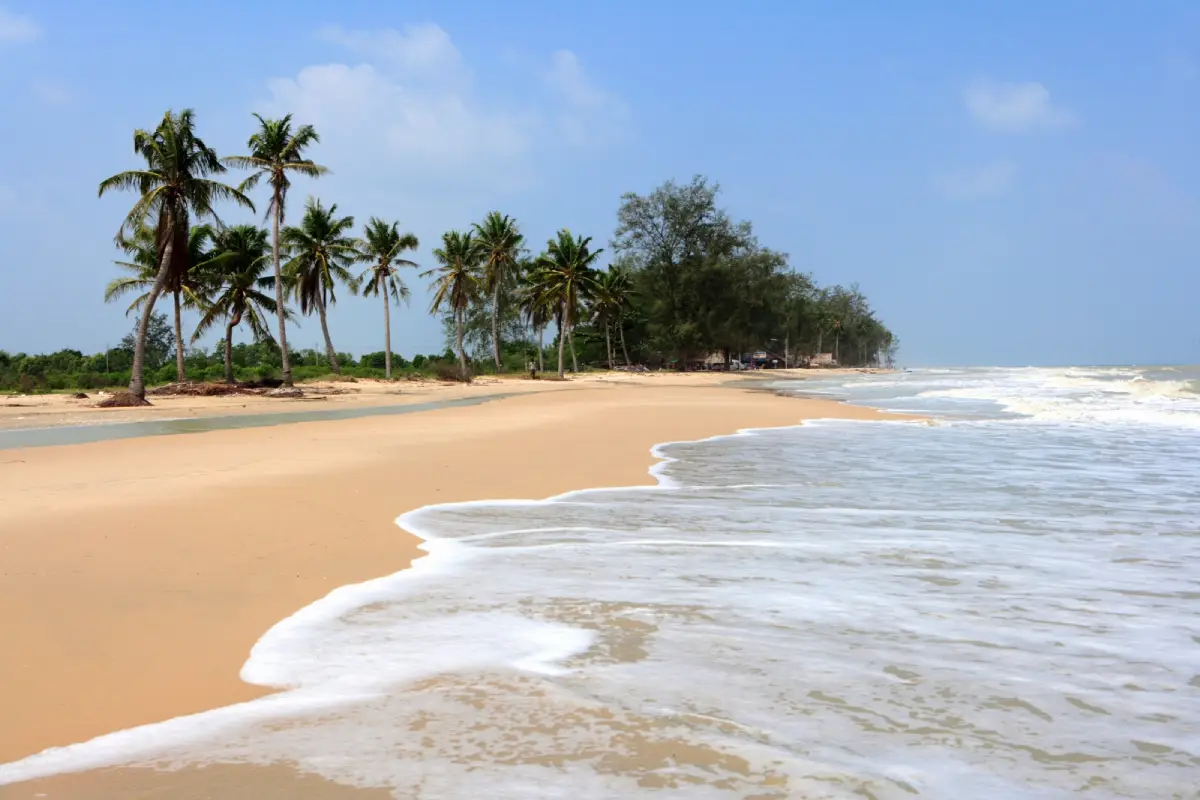
Pak Phanang Coast And Laem Talumphuk in Nakhon Si Thammarat is one of the most distinctive coastal landscapes in Pak Phanang District. Located in Laem Talumphuk Subdistrict, the area forms a long sandy cape between the inner waters of Pak Phanang Bay and the outer Gulf of Thailand. Its main features are the crescent-shaped sand spit, a long beach of about 6 km, rows of sea pines, local fishing communities, seafood restaurants, and a powerful historical memory connected with Tropical Storm Harriet in 1962.
Laem Talumphuk is more distinctive than an ordinary beach because it is a narrow sandy cape projecting into the sea. The inner side faces Pak Phanang Bay and is connected with local settlement and fishing life, while the outer side opens directly to the Gulf of Thailand, forming a long sandy beach with pine trees. This two-sided geography gives the area a unique character: part sheltered coastal community, part open sea beach.
The Pak Phanang coast around Laem Talumphuk is suitable for travelers who want a calm coastal route rather than a high-activity beach. Visitors can drive along the cape, enjoy the sea breeze, take photographs, walk on safe beach sections, and eat fresh seafood near the shoreline. The experience combines beach scenery, fishing culture, river-mouth geography, and the historical identity of Pak Phanang.
Laem Talumphuk is nationally remembered because of Tropical Storm Harriet, which struck the area on 25 October 1962. The storm caused severe damage to the cape, local communities, houses, and lives. The Thai Meteorological Department records the Harriet disaster at Laem Talumphuk as one of Thailand’s major windstorm disasters, with large numbers of deaths, missing persons, injuries, and displaced residents. Local travel narratives and community memory also describe abnormal storm surge, destructive waves, and deep trauma that remains part of the identity of the place.
This historical background makes Laem Talumphuk more than a scenic beach. It is also a place of remembrance. When visitors see the beautiful beach and pine-lined coast today, they are also standing in a landscape that once experienced one of the most devastating natural disasters in modern Thai history. A visit here should therefore be both relaxed and respectful.
Today, Laem Talumphuk remains open as a coastal recreation area. The landscape has been improved in several sections, and visitors can drive to the end of the cape, enjoy beach scenery, visit photo spots, and eat seafood nearby. The area is especially popular for those who want to combine Pak Phanang River, coastal history, and local food in one route.
The inner side of the cape is closely connected with Pak Phanang Bay and Pak Phanang River. Pak Phanang River flows through the basin before reaching the Gulf of Thailand at Pak Phanang and Laem Talumphuk. Historically, the Pak Phanang Basin was important for agriculture and trade, serving as a water route for transporting goods to the sea. This makes Laem Talumphuk part of a broader river-mouth system, not merely an isolated beach.
A good visit to Laem Talumphuk should be planned together with Pak Phanang town. Nearby places include Pak Phanang River, Uthokvibhajaprasid Watergate, riverside communities, old buildings, swiftlet houses, local markets, and boat trips along the river. This wider route helps visitors understand Pak Phanang as a river, fishing, coastal, and historical town.
The geography of Laem Talumphuk is both beautiful and vulnerable. A crescent-shaped sand spit is formed by waves, currents, and sediment movement. Such landforms can change with seasons, storms, and coastal erosion. Visitors should stay in safe areas, avoid strong-wave zones during monsoon periods, avoid climbing coastal protection structures, and avoid damaging the pine-lined beach environment.
Appropriate activities include driving along the cape, photographing the crescent beach, resting under the sea pines, walking during calm weather, learning about the Harriet storm, and eating seafood near the beach. The area should not be treated as a careless swimming beach, especially on the outer Gulf of Thailand side where wind and waves can change quickly.
The best time to visit is in the morning or late afternoon. Morning offers cooler air and softer light for beach walking and photography. Late afternoon is suitable for sea breeze and seafood dining. Midday can be hot and sunny, so visitors should prepare drinking water, sun protection, a hat, and sunglasses. During rainy or monsoon periods, visitors should check weather conditions before traveling.
Getting There from Nakhon Si Thammarat city is straightforward by private car or rental car. Take Highway 4013, the Nakhon Si Thammarat–Pak Phanang route, toward Pak Phanang District. Then follow the local road toward Laem Talumphuk Subdistrict and continue along the cape. Navigation and local signs are useful for reaching the beach and the end of the cape.
From Pak Phanang town, the route continues toward Laem Talumphuk communities and the beach. Visitors without a private vehicle can first travel to Pak Phanang and then hire local transport to Laem Talumphuk, but return transport should be arranged in advance because the end of the cape does not have frequent public transport throughout the day.
A practical itinerary can start in Pak Phanang town, continue to Pak Phanang River or Uthokvibhajaprasid Watergate, then proceed to Laem Talumphuk beach and the end of the cape, and finish with seafood near the shoreline. With more time, visitors can add Pak Phanang retro market, Wat Pak Phraek, or a river boat trip to see riverside life and the river-mouth ecosystem.
Visitors should keep the beach clean, avoid throwing rubbish into the sea, avoid damaging sea pines, avoid blocking community roads, respect private areas, and treat the Harriet disaster memory with respect. Families with children should supervise them closely near the sea because the area includes open beaches, strong wind, and seasonal waves.
Overall, Pak Phanang Coast and Laem Talumphuk combine nature, history, and community life in one place. The crescent-shaped cape, sandy beach, sea pines, fishing community, seafood culture, Pak Phanang River context, and the memory of Tropical Storm Harriet make it one of the most meaningful coastal destinations in Nakhon Si Thammarat.
| Name | Pak Phanang Coast And Laem Talumphuk |
| Location | Laem Talumphuk Subdistrict, Pak Phanang District, Nakhon Si Thammarat Province |
| Address | Laem Talumphuk Subdistrict, Pak Phanang District, Nakhon Si Thammarat 80140, Thailand |
| Laem Talumphuk Reference Coordinates | 8.518325, 100.113307 |
| Place Type | Beach And Bay / Sandy Cape / Natural And Historical Coastal Attraction |
| Highlights | Crescent-shaped sandy cape, about 6 km beach, sea pine rows, Gulf of Thailand coast, Pak Phanang Bay, seafood restaurants, and the historic 1962 Tropical Storm Harriet disaster site |
| Distinctive Features | The inner side faces Pak Phanang Bay and fishing communities, while the outer side faces the Gulf of Thailand with sandy beach and pine trees. Visitors can drive along the cape toward the tip. |
| Historical Importance | The area was severely affected by Tropical Storm Harriet on 25 October 1962, one of Thailand’s major windstorm disasters. |
| Main Zones | Gulf-facing beach, sea pine shoreline, Pak Phanang Bay side, fishing community area, road to the cape tip, photo spots, and seafood restaurant zone near the beach |
| Travel Information | From Nakhon Si Thammarat city, take Highway 4013 toward Pak Phanang District, then follow local roads toward Laem Talumphuk Subdistrict and the cape. Private car or rental car is the most convenient option. |
| Current Status | Open as a coastal attraction and recreation area in Pak Phanang District, still listed in provincial tourism information and Laem Talumphuk Subdistrict Administrative Organization’s tourism information |
| Open Days | Daily |
| Opening Hours | 08.00 – 17.00 |
| Caretaker / Local Authority | Laem Talumphuk Subdistrict Administrative Organization and local communities in Laem Talumphuk Subdistrict |
| Local Contact Number | Laem Talumphuk Subdistrict Administrative Organization, Tel. 075-809-955 |
| Safety Notes | Watch for monsoon waves, avoid entering the sea during rough conditions, keep the beach clean, avoid damaging pine trees, avoid unnecessary climbing on coastal protection structures, and check weather conditions before travel. |
| Nearby Tourist Attractions | 1. Laem Talumphuk Cape Tip, about 0 km 2. Laem Talumphuk Beach, about 0 km 3. Pak Phanang River / Pak Phanang River Boat Trip, about 15 km, Tel. 075-517-266, 075-517-630, 075-517-058 4. Uthokvibhajaprasid Watergate, about 17 km 5. Pak Phanang Retro Market, about 18 km, Tel. 075-517-266 6. Wat Pak Phraek, Pak Phanang, about 18 km |
| Nearby Restaurants | 1. Krua Anurak Seafood Laem Talumphuk, about 1 km, Tel. 089-591-9622, 086-594-4580 2. Krua Kamnan Laem Talumphuk, about 1 km 3. Cha Arun / Krua Lam Thong Seafood, about 1 km 4. Krua Lamphu Laem Talumphuk, about 1 km 5. Krua Mueang Nang Seafood At Pak Phanang Hotel, about 18 km, Tel. 075-517-016 6. Chai Le Seafood Pak Nakhon, about 25 km |
| Nearby Accommodations | 1. Baan Argong Homestay Pakphanang, about 18 km, Tel. 090-621-8319, 095-165-1495 2. Pakphanang Village, about 18 km, Tel. 095-246-8222 3. Pak Phanang Hotel, about 18 km, Tel. 075-517-016 4. Tang May Resort, about 20 km 5. Hotels In Nakhon Si Thammarat City, about 55 km |
Frequently Asked Questions (FAQ)
Q: Where are Pak Phanang Coast and Laem Talumphuk located?
A: They are located in Laem Talumphuk Subdistrict, Pak Phanang District, Nakhon Si Thammarat Province, where a sandy cape extends into the Gulf of Thailand and connects with Pak Phanang Bay.
Q: What are the opening days and hours?
A: The area is open daily from 08.00 to 17.00. Morning and late afternoon are the most suitable times to visit.
Q: What is interesting at Laem Talumphuk?
A: The area features a crescent-shaped sandy cape, a beach of about 6 km, sea pines, fishing communities, fresh seafood, and the history of Tropical Storm Harriet in 1962.
Q: How is Tropical Storm Harriet connected with Laem Talumphuk?
A: Tropical Storm Harriet struck Laem Talumphuk and Nakhon Si Thammarat on 25 October 1962, causing severe damage and becoming one of Thailand’s major windstorm disasters.
Q: Can visitors drive to the tip of Laem Talumphuk?
A: Yes. Visitors can drive along the cape toward the tip, but should do so carefully and avoid visiting exposed beach areas during rough weather or strong waves.
Q: Is Laem Talumphuk suitable for swimming?
A: It is better suited for sightseeing and seaside relaxation than careless swimming. Visitors should check wave and wind conditions, especially on the Gulf of Thailand side and during monsoon periods.
Q: What should visitors be careful about?
A: Visitors should watch for waves, avoid rough seas, keep the beach clean, avoid damaging sea pines, avoid blocking local roads, and check weather conditions before traveling.
Q: What nearby places can be combined with Laem Talumphuk?
A: Nearby places include Pak Phanang River, Uthokvibhajaprasid Watergate, Pak Phanang Retro Market, Wat Pak Phraek, and Pak Phanang river boat trips.
 Category: ●Nature and Wildlife
 Group: ●Bays and Beaches
Last Update : 2 MonthAgo
 Last Update : 2 MonthAgo
 Click to Access the Navigation Map GPS
Pak Phanang Coast And Laem Talumphuk Map
Recommend

 Art, Culture and Heritage
 Historical Sites and Monuments(9)
 Landmarks and Memorials(9)
 Royal Palace(1)
 Art, Craft Centres, Tradition(12)
 Museums(5)
 Educational Places
 Educational Gardens, Farm(2)
 Places of Worship
 Temple(44)
 Mosque(2)
 Other Sacred Sites(17)
 Research and Development
 Royal Project(2)
 Suburban Living
 Village, Community(8)
 Local Market(1)
 Floating Market(1)
 National Parks and Marine Reserves(6)
 Mountain (Doi)(11)
 Dam, Reservoir, Lake(10)
 Waterfalls(43)
 Hot Springs(1)
 Caves(13)
 River, Canal(3)
Bays and Beaches(29)
 Islands(2)
 Other natural attractions(3)
 Entertainment and Agricultural
 Farms, Parks and Ecotourism(3)
 Outdoor and Adventure Activities(4)
 Travel Articles, Recipes
 Travel Review, Food Review(5)
 Southern Food Menu, Southern Food Recipes(18)


