
lovethailand home >North Travel Attractions >Nan Travel Attractions >Chaloem Phrakiat >Huai Kon > Wang Pian Waterfall
TL;DR: Wang Pian Waterfall is located at Ban Huai Sai Khao, Moo 7, Huai Kon Subdistrict, Chaloem Phra Kiat District, Nan Province, hours 08.00 - 17.00. Highlights include 6-level waterfall with layered rock formations, natural pools, and forest scenery.

Wang Pian Waterfall

Opening days: Daily
Opening hours: 08.00 - 17.00
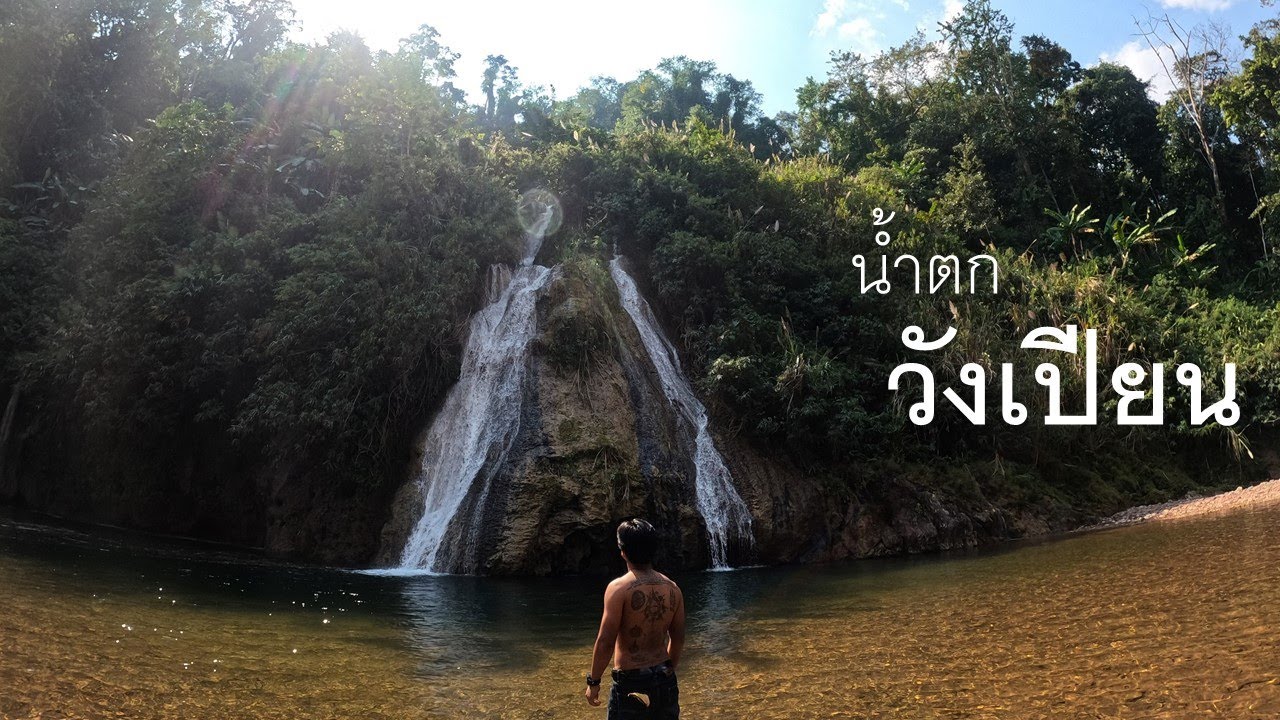
Wang Pian Waterfall, also known locally as Huai Kon Waterfall, is a natural waterfall located in Ban Huai Sai Khao, Moo 7, Huai Kon Subdistrict, Chaloem Phra Kiat District, Nan Province. It is approximately 11 kilometers from the district center. The waterfall is known for its complex rock formations and 6 cascading levels, surrounded by forests, streams, and peaceful mountain scenery in northern Nan.
The main highlight of Wang Pian Waterfall is its layered natural rock structure. Water flows over rocks and cliffs, forming several waterfall levels and natural pools. The first level is approximately 30 meters high and has a pool suitable for swimming, while the second level is approximately 50 meters high and is considered one of the most beautiful parts of the waterfall.
Wang Pian Waterfall has 6 levels. The waterfall levels have long been known by traditional local names, including Tad Man, Pha Khan Thai, Pha Chom, Tad Ling, and Tad Mok or Huai Hok. These names reflect the natural landscape, rock formations, and the close relationship between the local community, forests, and streams in Huai Kon Subdistrict.
The area around the waterfall is shaded by forest trees, riverside plants, and mountain vegetation. The sound of flowing water creates a relaxing atmosphere suitable for visitors who want to spend time in nature, take photographs, swim carefully in safe areas, or walk along the streamside scenery.
The best time to visit Wang Pian Waterfall is from the rainy season to the early cool season, when the water flow is strong and the surrounding forest becomes lush green. During the dry season, the amount of water may decrease, but the area still remains suitable for nature walks and quiet relaxation.
Wang Pian Waterfall is also important to Ban Huai Sai Khao and Huai Kon Subdistrict as a local natural attraction connected with community life, water resources, and local tourism. Visitors can experience both the beauty of the waterfall and the atmosphere of a northern border community in Chaloem Phra Kiat District.
Getting There is possible by traveling from Chaloem Phra Kiat District center to Ban Huai Sai Khao, Moo 7, Huai Kon Subdistrict, for approximately 11 kilometers. Visitors can travel by private car or motorcycle. The route passes through rural and natural areas, so extra caution is recommended during the rainy season.
Visitors should help protect the waterfall by keeping the area clean, avoiding littering, respecting the forest environment, and being careful while walking on rocks or swimming in natural pools.
| Name | Wang Pian Waterfall |
| Location | Ban Huai Sai Khao, Moo 7, Huai Kon Subdistrict, Chaloem Phra Kiat District, Nan Province |
| Coordinates | 19.5886, 101.0804 |
| Type | Waterfall and natural attraction |
| Highlights | 6-level waterfall with layered rock formations, natural pools, and forest scenery |
| Waterfall Details | The first level is approximately 30 meters high with a natural swimming pool The second level is approximately 50 meters high and is especially scenic The waterfall has 6 levels known locally as Tad Man, Pha Khan Thai, Pha Chom, Tad Ling, and Tad Mok or Huai Hok |
| Distinctive Features | Natural cascading rocks, flowing streams, forest surroundings, and pools suitable for careful swimming |
| Travel Information | Approximately 11 km from Chaloem Phra Kiat District center to Ban Huai Sai Khao, Huai Kon Subdistrict |
| Current Status | Open as a local natural attraction |
| Facilities | Natural pools, streamside rest areas, and nature walking areas |
| Managed By | Ban Huai Sai Khao community and local administrative organizations |
| Nearby Tourist Attractions | 1. Ban Huai Sai Khao, about 1 km 2. Huai Kon Border Checkpoint, about 15 km 3. Huai Kon Border Market, about 15 km 4. Chaloem Phra Kiat District Center, about 11 km 5. Huai Kon Travel Route, about 10 km |
| Nearby Restaurants | 1. Ban Huai Sai Khao Community Restaurant, about 1 km 2. Huai Kon Local Restaurant, about 10 km 3. Huai Kon Border Market Food Shops, about 15 km 4. Restaurants in Chaloem Phra Kiat District, about 11 km 5. Local Restaurants along Huai Kon Route, about 10 km |
| Nearby Accommodations | 1. Ban Huai Sai Khao Homestay, about 1 km 2. Huai Kon Community Accommodation, about 10 km 3. Accommodation near Huai Kon Border Checkpoint, about 15 km 4. Accommodation in Chaloem Phra Kiat District, about 11 km 5. Huai Kon Community Homestays, about 10 km |
Frequently Asked Questions (FAQ)
Q: Where is Wang Pian Waterfall located?
A: It is located in Ban Huai Sai Khao, Moo 7, Huai Kon Subdistrict, Chaloem Phra Kiat District, Nan Province.
Q: How many levels does Wang Pian Waterfall have?
A: Wang Pian Waterfall has 6 levels.
Q: How high is the first level of Wang Pian Waterfall?
A: The first level is approximately 30 meters high and has a natural pool suitable for swimming.
Q: What is special about the second level?
A: The second level is approximately 50 meters high and is considered one of the most beautiful parts of the waterfall.
Q: How far is Wang Pian Waterfall from the district center?
A: It is approximately 11 kilometers from Chaloem Phra Kiat District center.
Q: What should visitors be careful about?
A: Visitors should be careful on slippery rocks, wet paths, and changing water levels during the rainy season.
 Category: ●Nature and Wildlife
 Group: ●Waterfalls
Last Update : 6 MonthAgo
 Last Update : 6 MonthAgo
 Click to Access the Navigation Map GPS
Wang Pian Waterfall Map
Recommend

 Art, Culture and Heritage
 Landmarks and Memorials(6)
 Art, Craft Centres, Tradition(6)
 Museums(4)
 Historic Homes and Cities(1)
 Art Gallery(1)
 Educational Places
 Educational Gardens, Farm(1)
 Places of Worship
 Temple(68)
 Church(1)
 Other Sacred Sites(19)
 Research and Development
 Royal Project(2)
 Suburban Living
 Village, Community(13)
 Local Market(1)
 National Parks and Marine Reserves(9)
 Mountain (Doi)(6)
 Dam, Reservoir, Lake(16)
Waterfalls(28)
 Hot Springs(1)
 Caves(11)
 River, Canal(5)
 Other natural attractions(10)
 Entertainment and Agricultural
 Farms, Parks and Ecotourism(4)
 Outdoor and Adventure Activities(2)
 Travel Articles, Recipes
 Travel Review, Food Review(1)


