
lovethailand home >Eastern Travel Attractions >Chanthaburi Travel Attractions > 50 Best Places to Visit in Chanthaburi 2027
TL;DR: 50 Best Places to Visit in Chanthaburi 2027. Chanthaburi is one of Eastern Thailand’s most diverse travel destinations, combining an old riverside town, historic religious sites, the.

50 Best Places to Visit in Chanthaburi 2027
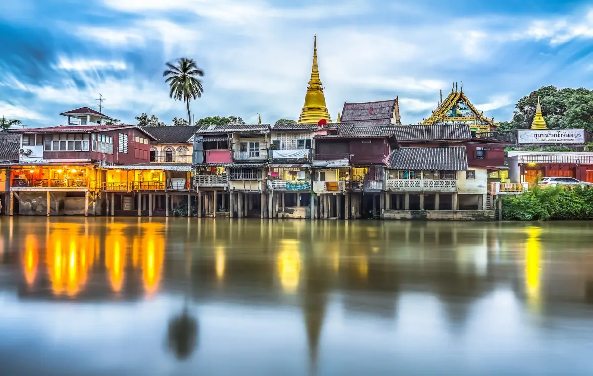
50 Best Places to Visit in Chanthaburi 2027 Chanthaburi is one of Eastern Thailand’s most diverse travel destinations, combining an old riverside town, historic religious sites, the legacy of King Taksin the Great, a nationally important gemstone district, tropical fruit orchards, mountains, waterfalls, evergreen forests, mangroves, and a long coastline stretching through Na Yai Am, Tha Mai, Laem Sing, and Khlung. This variety makes Chanthaburi suitable for both a short 2-day, 1-night getaway and a more complete 3–5 day journey.
For first-time visitors, some of the best places to begin are the Chanthaboon Riverside Community, the Cathedral of the Immaculate Conception, Khao Khitchakut National Park, Namtok Phliu National Park, Laem Sing Beach, Kung Wiman Beach, Tuek Daeng, Kook Kee Kai, Si Chan Road’s gemstone district, and the Welu Wetland mangrove area. Together, these destinations reveal the province’s main identities: history, faith, nature, beaches, local communities, and the gemstone trade.
Chanthaburi has a remarkably varied landscape. The northern and eastern parts of the province are dominated by mountains and forests that form the headwaters of several rivers, especially around Khao Khitchakut and the Khao Sa Bap mountain range. The central area contains plains and agricultural land, while the south opens onto the Gulf of Thailand with river mouths, bays, capes, sandy beaches, islands, and mangrove ecosystems.
The province’s fertile soil and abundant rainfall have made Chanthaburi one of Thailand’s most important fruit-growing regions, particularly for durian, mangosteen, rambutan, and longkong. Fruit season is therefore one of the most interesting times to visit, when travelers can enter orchards, taste fresh produce, and learn about local agriculture while combining the experience with nature and cultural attractions.
Chanthaburi is also famous nationally and internationally as one of Thailand’s great gemstone cities. The area around Si Chan Road and Soi Krachang developed into a major trading district for gemstones and jewelry, bringing together traders, cutters, collectors, and buyers from many countries. This long-established gemstone culture distinguishes Chanthaburi from other coastal provinces in Eastern Thailand.
Historically, Chanthaburi played an important role in the restoration of Siamese independence after the fall of Ayutthaya. King Taksin the Great used Chanthaburi as a base to gather troops, supplies, and weapons before returning west to reclaim the capital. That history is still reflected in shrines, monuments, the city pillar, and local historical narratives throughout the provincial capital.
Another important historical period was the French occupation of Chanthaburi following the Franco-Siamese crisis of 1893. Remnants of that period remain at Laem Sing, particularly Tuek Daeng and Kook Kee Kai. These sites give the coastal route an important historical dimension beyond beaches and seafood.
Chanthaburi’s cultural identity developed through the coexistence of Thai, Chinese, Vietnamese, Chong, and Roman Catholic communities. This diversity remains visible in the Chanthaboon Riverside Community, old shophouses, shrines, Buddhist temples, and the Cathedral of the Immaculate Conception, one of the most distinctive Christian landmarks in Thailand.
Local food is another strong reason to stay in Chanthaburi rather than simply pass through. Signature dishes include moo chamuang, stir-fried Chanthaburi rice noodles with crab, fresh seafood, and dishes seasoned with Chanthaburi pepper. During fruit season, durian, mangosteen, rambutan, and longkong can also become an essential part of the trip.
For easier trip planning, Chanthaburi can be divided into several major travel zones: the Old Town zone for the riverside community, cathedral, gemstone market, and King Taksin history; Khao Khitchakut–Makham for mountains, waterfalls, and pilgrimage routes; Tha Mai–Na Yai Am for Chao Lao Beach, Kung Wiman, viewpoints, and orchards; Laem Sing for Namtok Phliu, beaches, Tuek Daeng, and Kook Kee Kai; and Khlung for mangroves, local communities, and firefly activities.
If you have only 1 day, focus on the old town, riverside community, cathedral, and gemstone district. With 2–3 days, add Namtok Phliu, Laem Sing, and Kung Wiman. Travelers with 4–5 days should also include Khao Khitchakut, fruit orchards, Khlung’s mangroves, and additional coastal areas for a more complete experience.

1. Chanthaboon Riverside Community is a historic neighborhood along the Chanthaburi River with more than 300 years of history. It is one of the best places to begin exploring the province because the area was once an important center of trade, river transport, and settlement for Thai, Chinese, and Vietnamese communities. Their influence remains visible in the architecture, religion, food, and daily life of the neighborhood.
Highlight: Sukhaphiban Road follows the river and forms the heart of the old community. Traditional wooden houses, historic shophouses, Thai-Chinese details, Western architectural influences, gingerbread-style woodwork, ventilation panels, balconies, and decorative façades can still be seen along the route.
Historically, the district was divided into northern, central, and southern market areas, each serving different commercial functions including wholesale trade, retail trade, and river transport. The importance of the Chanthaburi River made this neighborhood a major economic center before modern road networks changed patterns of commerce.
Today, the area is best explored slowly on foot. Visitors will find local restaurants, cafés, traditional dessert shops, antique stores, small guesthouses, local products, and historic buildings adapted for modern use. Much of the area’s charm lies in its details rather than in a single large landmark.
Across the river stands the Cathedral of the Immaculate Conception, making it easy to combine the two attractions. Si Chan Road and the gemstone district are also nearby, allowing visitors to create a half-day route focused on old-town culture, religion, and gemstones.
Morning is ideal for photographing architecture before temperatures rise, while late morning and afternoon are better for food and café stops. Travelers who prefer a quieter atmosphere should avoid major public holidays when the area can become crowded.
Getting There: From Highway 3, turn onto Highway 316 at Khao Rai Ya Intersection and continue toward central Chanthaburi. Enter Tha Luang Road and the Sukhaphiban Road area. Parking is available around nearby temples and designated areas, after which the neighborhood is best explored on foot.
Map (GPS): https://www.google.com/maps/dir/?api=1&destination=12.611072,102.114344&travelmode=driving

2. Cathedral of the Immaculate Conception is one of Chanthaburi’s most important religious landmarks and the spiritual center of the local Roman Catholic community. Located on the eastern bank of the Chanthaburi River near the old riverside quarter, the cathedral is one of the most recognizable Christian buildings in Eastern Thailand.
Highlight: The cathedral is distinguished by Gothic-inspired architecture, twin towers, tall arched windows, and stained glass. Its visual character contrasts sharply with nearby Buddhist temples and Chinese shrines, making it a strong symbol of Chanthaburi’s religious and cultural diversity.
The history of Catholicism in Chanthaburi dates back several centuries. Early churches were established to serve Vietnamese Catholic communities that settled in the area, and the place of worship was rebuilt and expanded several times as the local Catholic population grew.
The present building was developed in the early 20th century and became an important center of Catholic faith in Eastern Thailand. Its architecture and religious role make it valuable both as a functioning place of worship and as a historical attraction.
Visitors should remain quiet inside because religious services are still held regularly. Dress modestly, avoid disturbing worshippers, and wait until Mass has ended before exploring the interior in detail.
The cathedral is directly connected with the Chanthaboon Riverside Community and can easily be visited on the same walking route before continuing to Si Chan Road or the King Taksin heritage area.
Getting There: From central Chanthaburi, cross Wat Chan Bridge toward Chanthanimit Road. Visitors can also walk directly from the riverside community across the bridge to the cathedral.
Map (GPS): https://www.google.com/maps/dir/?api=1&destination=12.609620,102.119286&travelmode=driving

3. Khao Khitchakut National Park is one of Chanthaburi’s most important natural and spiritual destinations. The park covers mountainous forest in Makham and Khao Khitchakut districts and forms an important watershed for the Chanthaburi River. Its landscape includes tropical evergreen forest, mountain forest, streams, and waterfalls.
Highlight: Khao Khitchakut is famous throughout Thailand for the annual pilgrimage to the Buddha Footprint on Khao Phra Bat. During the pilgrimage season, large numbers of worshippers travel up the mountain to pay respect at sacred points along the route.
The park is also home to Krathing Waterfall, a large multi-tiered waterfall surrounded by forest. This makes Khao Khitchakut attractive outside the pilgrimage season as well, especially for travelers interested in hiking, waterfalls, and tropical ecosystems.
The forest contains a wide range of plants and wildlife, including medicinal plants, orchids, agarwood species, birds, and other forest animals. Its ecological value is therefore as important as its religious significance.
Visiting the Buddha Footprint requires more planning than a normal national park visit because the upper pilgrimage route opens only during a designated annual period. From Wat Phluang, visitors normally continue by local mountain transport before walking farther uphill.
Travelers who do not plan to climb to the summit can still enjoy Krathing Waterfall and other natural areas within the park, making the destination suitable for both pilgrims and nature travelers.
Getting There: From Chanthaburi city, follow Sukhumvit Road to Khao Rai Ya Intersection, then take Highway 3249 toward Khao Khitchakut District and Wat Phluang. Visitors planning to join the pilgrimage should check the official seasonal opening dates and transport system before traveling.
Map (GPS): https://www.google.com/maps/dir/?api=1&destination=12.851608,102.168547&travelmode=driving

4. Namtok Phliu National Park is one of Chanthaburi’s best-known natural attractions. Located within the Khao Sa Bap forest area, the park combines tropical evergreen forest, streams, mountains, and waterfalls and is an important watershed area for the province.
Highlight: Phliu Waterfall flows throughout the year and forms a clear pool at its lower section. One of the most memorable sights is the large population of freshwater fish living naturally in the stream, giving visitors a close look at a healthy freshwater ecosystem.
The park was officially declared a national park in 1975. It was originally known as Khao Sa Bap National Park before later being renamed after Phliu Waterfall, the area’s best-known natural landmark.
The name “Phliu” is connected with the Chong language, reflecting the cultural influence of the indigenous Chong people of Eastern Thailand and linking the natural landscape with local cultural history.
The waterfall also has a strong royal connection. King Chulalongkorn, Rama V, visited the area several times, and memorials associated with those visits remain part of the park’s historical significance.
Namtok Phliu can easily be combined with Laem Sing Beach, Tuek Daeng, and Kook Kee Kai in a single day, creating a route that includes forest, waterfall, coast, and history.
Getting There: From Chanthaburi city, follow Sukhumvit Road toward Trat and turn onto the access road to Namtok Phliu National Park. The park is approximately 14 kilometers from the city and is accessible by standard passenger vehicles.
Map (GPS): https://www.google.com/maps/dir/?api=1&destination=12.527270,102.182129&travelmode=driving

5. Laem Sing Beach lies near the mouth of the Chanthaburi River in Laem Sing District. Its landscape combines the sea, river mouth, hills, offshore islands, and fishing communities, giving it a different atmosphere from a typical open-coast beach.
Highlight: The curved shoreline opens toward the river mouth and offers views of Laem Sing Hill and nearby islands. Morning and evening are particularly pleasant for walking, photography, and watching local fishing boats.
Seafood is one of the major attractions of the area. Local restaurants serve prawns, crab, fish, shellfish, and regional dishes using seafood landed by fishing communities around the river mouth.
Depending on weather and local services, boat trips and marine activities may also be available. Travelers should always check sea conditions and safety equipment before joining any boat excursion.
Laem Sing is especially attractive because nature and history are close together. The beach can easily be combined with Tuek Daeng and Kook Kee Kai, both connected with the period of French occupation in Chanthaburi.
A full-day route can begin at Namtok Phliu in the morning, continue to Tuek Daeng and Kook Kee Kai in the afternoon, and end at Laem Sing Beach with seafood in the evening.
Getting There: From Chanthaburi city, follow Sukhumvit Road toward Trat, then turn onto Highway 3149 toward Laem Sing District and continue to Pak Nam Laem Sing.
Map (GPS): https://www.google.com/maps/dir/?api=1&destination=12.477778,102.070000&travelmode=driving

6. Kung Wiman Beach in Na Yai Am District is known for its peaceful atmosphere and beautifully curved coastline. Its appeal extends beyond the beach itself because it connects directly with Chanthaburi’s famous coastal scenic road and several viewpoints.
Highlight: The curved bay is especially beautiful when seen from higher ground. Morning and late afternoon offer the best light for walking and photography, while the surrounding coastal road provides excellent panoramic views.
One of the area’s defining features is Chalerm Burapha Chonlathit Road, a scenic coastal route passing beaches, hills, bays, and viewpoints across Eastern Thailand.
The beachfront has resorts, guesthouses, local seafood restaurants, and other visitor services. Staying overnight allows travelers to experience both the quieter morning atmosphere and evening sea views.
Kung Wiman is well suited to couples, families, cycling travelers, photographers, and road-trip visitors looking for a quieter beach without giving up convenient road access.
The beach can be combined with Chao Lao Beach, Noen Nang Phaya Viewpoint, and the Kung Krabaen Bay area in a single coastal itinerary.
Getting There: From Chanthaburi city, travel toward Na Yai Am District via Sukhumvit Road, then turn toward the coast following signs for Kung Wiman. The beach connects directly with Chalerm Burapha Chonlathit Road.
Map (GPS): https://www.google.com/maps/dir/?api=1&destination=12.604435,101.875440&travelmode=driving

7. Tuek Daeng is an important historical building in Pak Nam Laem Sing and one of the clearest surviving reminders of the period when French forces occupied Chanthaburi following the Franco-Siamese crisis of 1893.
Highlight: The long, single-story red masonry building is simple but visually distinctive. Wooden doors and windows, its elongated form, and surrounding veranda reflect practical architecture adapted to a hot and humid coastal climate.
Tuek Daeng was built in 1893 during the French occupation and formed part of the military presence around the strategic river mouth at Laem Sing.
After French forces withdrew, the building was used for several purposes, including educational functions, before being preserved as a historical site.
Tuek Daeng should be visited together with Kook Kee Kai, which stands nearby and belongs to the same historical context. Seeing both gives a much clearer understanding of the Laem Sing area during the period of foreign military control.
From Tuek Daeng, travelers can continue directly to Laem Sing Beach and nearby seafood areas, making it easy to combine historical sightseeing with the coast.
Getting There: From Chanthaburi city, follow Sukhumvit Road toward Trat and then Highway 3149 toward Laem Sing District. Tuek Daeng is located around Pak Nam Laem Sing and is very close to Kook Kee Kai.
Map (GPS): https://www.google.com/maps/dir/?api=1&destination=12.481267,102.062005&travelmode=driving

8. Kook Kee Kai is a historic structure in Laem Sing District associated with the period of French occupation in Chanthaburi during the late 19th century. Its unusual square tower-like form makes it one of the most visually distinctive historic structures in the province.
Highlight: The structure is approximately 4 meters square and about 10 meters high, with ventilation openings arranged at several levels. Its appearance resembles a tower or defensive structure more than a conventional prison.
A popular local story claims that chickens were kept on the upper level and that their droppings fell onto prisoners below, giving rise to the name “Kook Kee Kai,” or “chicken-dropping prison.” Historical interpretations also suggest that the structure may have served defensive or observation functions.
This uncertainty is part of what makes the site interesting. Visitors should consider the structure within the broader military importance of Laem Sing during the French occupation rather than viewing it only through the popular prison story.
The building has been preserved as a historical monument. A short visit is enough to examine its shape, ventilation openings, and relationship to Tuek Daeng and the nearby coast.
After visiting Kook Kee Kai, travelers can continue to Tuek Daeng, Laem Sing Beach, and nearby seafood restaurants.
Getting There: From Chanthaburi city, take Sukhumvit Road toward Trat and turn onto Highway 3149 before reaching Laem Sing. The building stands beside the road and is very close to Tuek Daeng.
Map (GPS): https://www.google.com/maps/dir/?api=1&destination=12.481326,102.065707&travelmode=driving

9. Si Chan Road — Chanthaburi Gemstone Market is one of the places that best expresses Chanthaburi’s identity as Thailand’s gemstone city. The trading area centers around Si Chan Road and Soi Krachang, where gemstone shops, cutters, jewelry businesses, brokers, and traders operate side by side.
Highlight: The real attraction is not only buying jewelry but observing the gemstone trade itself: stones placed on trading tables, examination with magnifying lenses, evaluation of color and clarity, weighing, negotiation, and direct interaction between buyers and sellers.
Chanthaburi has long been known for gemstone cutting and heat-treatment expertise. These skills have been passed down through generations, turning the market into both a trading center and a center of technical knowledge.
The district is usually busiest toward the end of the week, when Thai and international traders gather to buy and sell gemstones.
Visitors planning to purchase gemstones should choose reputable sellers, request certification when appropriate, and avoid judging quality by price alone. Gemstones vary according to type, weight, color, clarity, cutting quality, and treatment.
Si Chan Road is close to the Chanthaboon Riverside Community and the cathedral, making it easy to combine all three in a single city itinerary.
Getting There: Si Chan Road is located in central Chanthaburi around Si Chan Road and Soi Krachang. It is only a short drive from the riverside old town and other central attractions.
Map (GPS): https://www.google.com/maps/dir/?api=1&destination=12.606891,102.115258&travelmode=driving

10. Mangrove Resource Development Station 2 in Welu River (Welu Wetland) is located at Ban Tha Son in Bo Subdistrict, Khlung District. It offers a different side of Chanthaburi, focusing on mangrove ecology, wetlands, birdlife, and community-based nature tourism rather than mountains or beaches.
Highlight: A nature trail of approximately 1.2 kilometers leads through mangrove forest containing species such as mangroves and Avicennia. Along the way, visitors can observe crabs, small fish, mudflat organisms, and the complex root systems that support the coastal ecosystem.
The area is also a good birdwatching destination, especially for waterbirds and birds of prey. Visitors interested in wildlife should walk quietly and slowly to improve the chance of seeing animals.
One of Ban Tha Son’s best-known activities is firefly watching in the mangrove forest. At night, fireflies gather around vegetation along waterways, creating a distinctive natural spectacle. Visibility varies with season and environmental conditions.
Other activities may include cycling and boat trips through the Welu River wetland, allowing travelers to experience the mangrove ecosystem from both boardwalk and water-level perspectives.
The destination is suitable for families, students, birdwatchers, couples, and eco-travelers. Visitors joining firefly tours should avoid flash photography and unnecessary disturbance to wildlife.
Getting There: From Chanthaburi city, follow Sukhumvit Road toward Khlung District. Around kilometer 374–375, turn toward Ban Tha Son in Bo Subdistrict. The area is approximately 18 kilometers from central Chanthaburi and is easiest to reach by private vehicle.
Map (GPS): https://www.google.com/maps/dir/?api=1&destination=12.383269,102.350662&travelmode=driving

11. Chao Lao Beach is one of the best-known seaside destinations in Tha Mai District and one of Chanthaburi’s most popular places for an overnight beach stay. The beach is known for its long stretch of pale sand, relatively peaceful atmosphere, coconut trees, seafood restaurants, and wide range of accommodation, making it suitable for families, couples, and groups of friends.
Highlight: Chao Lao Beach combines a relaxed coastal atmosphere with convenient tourism facilities. Visitors can walk along the beach, swim when sea conditions are suitable, relax under the shade of coconut trees, and enjoy fresh seafood from fishing communities along the Chanthaburi coast.
The beach is about 17 kilometers from Tha Mai District and is easily accessible by road. Its location allows visitors to enjoy a quieter coastal experience without traveling too far from the main town areas, making it suitable for both day trips and overnight stays.
Accommodation ranges from family resorts and small hotels to beachfront properties. Because of this variety, Chao Lao Beach works well as a base for exploring several coastal attractions rather than returning to Chanthaburi city every evening.
Seafood is a major attraction here. Local restaurants serve blue crab, prawns, squid, fish, shellfish, and regional dishes using ingredients sourced from nearby fishing communities.
Depending on weather and local operators, visitors may also find activities such as kayaking, snorkeling trips, or other marine recreation. Sea conditions should always be checked before joining activities, especially during the monsoon season.
Chao Lao Beach can easily be combined with the Kung Krabaen Bay Development Study Center, Laem Sadet, Noen Nang Phaya Viewpoint, and Kung Wiman Beach, making it one of the best bases for exploring the Tha Mai–Na Yai Am coastline.
Getting There: From Chanthaburi city, travel toward Tha Mai District and continue to the Chao Lao coastal area. Another option is to use Sukhumvit Road and turn onto Highway 3399 toward the beach. Private vehicles are the most convenient for visiting several attractions in the same coastal zone.
Map (GPS): https://www.google.com/maps/dir/?api=1&destination=12.533954,101.940969&travelmode=driving

12. Laem Sadet is a quiet coastal attraction in the Kung Krabaen Bay area of Tha Mai District. The site combines a long natural beach, coastal vegetation, shade from casuarina trees, and a peaceful setting that suits travelers who prefer nature-oriented seaside trips rather than busy resort beaches.
Highlight: Laem Sadet has a beach stretching for approximately 2–3 kilometers, with coastal trees providing natural shade. The atmosphere is particularly pleasant for relaxing, picnicking, walking along the shore, and enjoying sea views without large crowds.
The area is especially attractive from around November to April, when sea conditions are generally calmer and the water is often clearer. This period is well suited to beach activities and coastal photography.
Laem Sadet forms part of the wider Kung Krabaen coastal ecosystem, where mangroves, beach forest, marine habitats, and community-based conservation areas exist close together. It is therefore more than a beach stop and can be incorporated into an educational nature itinerary.
The location is suitable for families, couples, photographers, and travelers who want a quieter place to rest between other attractions in the Kung Krabaen area.
A practical itinerary is to visit the Kung Krabaen Bay Development Study Center in the morning, continue to the aquarium and Laem Sadet, and then finish the day at Chao Lao Beach or Noen Nang Phaya Viewpoint.
Getting There: Laem Sadet is approximately 25 kilometers from Tha Mai District. Follow the Tha Mai–Ban Mu Dut route toward Kung Krabaen Bay. Road signs are available along the route. Published visiting hours are 08.30–16.30.
Map (GPS): https://www.google.com/maps/dir/?api=1&destination=12.570852,101.890102&travelmode=driving

13. Kung Krabaen Bay Wildlife Sanctuary is a protected natural area near Kung Krabaen Bay in Tha Mai District. The landscape has undergone significant ecological restoration after earlier forest degradation, and the area now supports several different forest types within a relatively compact zone.
Highlight: Four forest ecosystems can be found here: dry evergreen forest, mixed deciduous forest, beach forest, and mangrove forest. This diversity makes the sanctuary particularly valuable for nature study and for understanding how different ecosystems connect between inland forest and the coast.
Restoration efforts have helped re-establish vegetation in areas that had previously been disturbed. Over time, the recovering forest has created better habitat for wildlife and improved the overall ecological condition of the Kung Krabaen area.
A nature trail leads through parts of the sanctuary and includes viewpoints overlooking Chao Lao Beach and the Khaem Nu estuary. A typical walk takes about 1 hour, depending on pace and stops for observation.
The sanctuary is closely connected with the work of the Kung Krabaen Bay Development Study Center and provides an excellent complement to the mangrove boardwalk and coastal learning areas nearby.
Visitors should wear suitable walking shoes, carry water, avoid disturbing wildlife, and remain on designated trails. Morning visits are generally more comfortable because of lower temperatures.
Getting There: The sanctuary is approximately 15 kilometers from Tha Mai District in the Kung Krabaen Bay area. It can be reached by private vehicle along the same coastal route used for Chao Lao Beach and Laem Sadet. Published visiting hours are 08.30–16.30.
Map (GPS): https://www.google.com/maps/dir/?api=1&destination=12.521446,101.949235&travelmode=driving

14. Nang Phaya Viewpoint is one of the most famous coastal viewpoints in Chanthaburi. Located along Chalerm Burapha Chonlathit Road in Na Yai Am District, it offers a panoramic view of the road curving between the hillside and the sea below.
Highlight: The sweeping view of the coastal road is the signature image of Nang Phaya Viewpoint. From the elevated position, visitors can see the winding road, the coastline, the surrounding hills, and the Gulf of Thailand in a single wide panorama.
Morning and late afternoon are particularly good for photography because the light is softer and the sea surface, road, and coastline show more detail than during the harsh midday sun.
The viewpoint has become one of the most recognizable stops on Chanthaburi’s coastal road-trip route. Travelers can stop briefly for photographs or stay longer to enjoy the breeze and watch the changing light over the sea.
Nang Phaya is suitable for couples, families, road-trip travelers, cyclists, and photographers. Visitors with children should take extra care around roadside and exposed viewing areas.
The viewpoint can easily be combined with Kung Wiman Beach, Chao Lao Beach, Kung Krabaen Bay, and Laem Sadet in a full-day coastal itinerary.
Getting There: From Chanthaburi city, travel toward Na Yai Am District and enter Chalerm Burapha Chonlathit Road following signs for Kung Wiman and Nang Phaya. Park only in designated areas and avoid stopping on bends. Published visiting hours are 08.00–17.00.
Map (GPS): https://www.google.com/maps/dir/?api=1&destination=12.591168,101.881217&travelmode=driving

15. Khao Soi Dao Waterfall is a major natural attraction inside Khao Soi Dao Wildlife Sanctuary in Soi Dao District. Surrounded by highly biodiverse forest, the waterfall is best suited to travelers who enjoy nature, hiking, and more adventurous outdoor trips.
Highlight: Khao Soi Dao Waterfall has 16 tiers. Each level has a different character, with water flowing over rock faces, through forest, and into natural pools surrounded by dense vegetation.
The waterfall lies about 4 kilometers from the wildlife sanctuary headquarters. Visitors continue on foot along a forest trail, making the experience as much about hiking through the ecosystem as about seeing the waterfall itself.
General visitors can normally hike as far as approximately the ninth tier, covering a route of around 2.5 kilometers. Higher sections require better physical preparation and greater caution because the terrain becomes steeper and more demanding.
The surrounding sanctuary is important for biodiversity conservation and supports a wide variety of plant and animal species. Travelers should avoid leaving the trail, making excessive noise, or disturbing wildlife.
During wetter months the waterfall is more powerful, but trails can also become slippery and flash-flood risks may increase. Check local conditions before entering the trail and follow all ranger instructions.
Getting There: Khao Soi Dao Waterfall is located inside Khao Soi Dao Wildlife Sanctuary in Sai Khao Subdistrict, Soi Dao District. Private vehicles are the most practical way to reach the sanctuary headquarters. Published visiting hours are 08.30–16.30.
Map (GPS): https://www.google.com/maps/dir/?api=1&destination=13.103282,102.193381&travelmode=driving

16. Khao Sip Ha Chan National Park is a large protected forest area in Khun Song Subdistrict, Kaeng Hang Maeo District. Covering more than 75,000 rai, or about 120 square kilometers, the park consists of a long mountain range connected ecologically with the Khao Soi Dao conservation area.
Highlight: The park’s highest point is Khao Sip Ha Chan, reaching approximately 802 meters above sea level. The landscape includes dry evergreen forest, deciduous forest, streams, wildlife habitat, and several waterfalls.
Important waterfalls within the area include Saba Waterfall, I Kek Waterfall, Nam Pen Waterfall, and Khao Sip Ha Chan Waterfall, also known as Khlong Sai Waterfall.
Khao Sip Ha Chan Waterfall is particularly notable for its series of approximately 15 tiers, with water flowing through forest and rocky terrain throughout much of the year.
The park is suitable for travelers interested in hiking, forests, waterfalls, wildlife, and less-developed natural areas. Visitors should prepare drinking water, suitable footwear, insect protection, and basic outdoor equipment.
Because the area remains relatively natural, facilities may be more limited than at major tourist parks. Travelers should plan conservatively and avoid entering remote areas late in the day.
Getting There: The park is located in Khun Song Subdistrict, Kaeng Hang Maeo District. Private transportation is the most convenient way to reach the area. Published visiting hours are 08.00–17.00.
Map (GPS): https://www.google.com/maps/dir/?api=1&destination=13.175995,102.002138&travelmode=driving

17. Khlong Narai Waterfall is a natural waterfall in Khlong Narai Subdistrict, Mueang Chanthaburi District. Although only a short distance from the provincial capital, the site offers a quiet forest atmosphere and a nature trail that feels far removed from the urban area.
Highlight: The waterfall is approximately 25 meters high, with clear water dropping from a rock face into a natural pool surrounded by trees and moisture-loving vegetation.
From the vehicle access area, visitors must continue on foot for roughly 2 kilometers through a forest trail. The walk provides an opportunity to experience streams, vegetation, and the sound of running water before reaching the waterfall.
Rainy-season conditions can make the waterfall more impressive, but the trail also becomes slippery. Hiking shoes with good grip are recommended, and visitors should avoid entering the water when currents are strong.
Khlong Narai is suitable for travelers looking for a quieter natural site close to Chanthaburi city and can be combined with other attractions in Mueang Chanthaburi District.
The waterfall also has local historical associations, adding cultural interest to the surrounding natural landscape rather than functioning only as a swimming or picnic area.
Getting There: From Chanthaburi city, follow the Chanthaburi–Trat road. Between approximately kilometer 338 and 339, turn onto the local access road for about 2 kilometers, then continue on foot for roughly another 2 kilometers. Published visiting hours are 06.00–18.00.
Map (GPS): https://www.google.com/maps/dir/?api=1&destination=12.581505,102.176174&travelmode=driving

18. Wat Khao Sukim is a well-known meditation temple in Khao Baisi Subdistrict, Tha Mai District. Located on a hillside surrounded by greenery, the temple is important both as a Buddhist practice center and as a cultural attraction for visitors interested in religion, sacred objects, and peaceful mountain scenery.
Highlight: The temple complex includes meditation areas, Buddhist halls, Buddha images, religious objects, and elevated viewpoints over the surrounding countryside. Its hillside setting gives the temple a distinctly tranquil character.
The origins of the temple are connected with forest monks and local villagers who gradually developed Khao Sukim into a place for meditation. Local stories also describe mysterious lights once seen around the summit, which became part of the area’s spiritual folklore.
Visitors can spend 1–2 hours exploring the religious buildings, paying respect to sacred images, and enjoying the mountain setting. Those interested in Buddhist collections and religious history may wish to allow more time.
The temple is particularly suitable for families, older travelers, Buddhist visitors, and those looking for a peaceful attraction away from the coast.
Dress modestly, keep noise to a minimum, and avoid disturbing areas used for meditation or monastic activities.
Getting There: From Chanthaburi city, travel toward Tha Mai District and Khao Baisi Subdistrict following signs for Wat Khao Sukim. The temple can be reached by road. Published visiting hours are 06.30–17.00.
Map (GPS): https://www.google.com/maps/dir/?api=1&destination=12.766261,102.032442&travelmode=driving

19. Oasis Sea World is located in Pak Nam Laem Sing, about 25 kilometers from Chanthaburi city. The attraction covers a large coastal site and is best known for its work with dolphins found in the Gulf of Thailand, combining marine education with visitor activities.
Highlight: Oasis Sea World focuses on two main dolphin species: Irrawaddy dolphins and bottlenose dolphins. Visitors can learn about their behavior, biology, and importance within the marine ecosystem.
The site has long been associated with dolphin breeding and care, and educational presentations are designed to introduce visitors to these intelligent marine mammals at close range.
Dolphin performances are presented in scheduled sessions during the day, with trained animals demonstrating behaviors such as jumping and swimming exercises. Visitors should check current show schedules before arrival.
The attraction is particularly suitable for families with children and travelers who want an activity different from beaches, temples, or historical sites.
Because it is located in Laem Sing, Oasis Sea World can easily be combined with Laem Sing Beach, Tuek Daeng, Kook Kee Kai, Taksin Maharat Bridge, and Khao Laem Sing Forest Park.
Getting There: Oasis Sea World is located in Pak Nam Subdistrict, Laem Sing District, approximately 25 kilometers from Chanthaburi city. Private vehicles are the most convenient option. Published visiting hours are 09.00–17.00.
Map (GPS): https://www.google.com/maps/dir/?api=1&destination=12.492162,102.069934&travelmode=driving

20. Khao Laem Sing Forest Park is located in Bang Kachai Subdistrict, Laem Sing District, and covers both terrestrial and coastal environments. The protected area extends across approximately 9,500 rai and contains dry evergreen forest, beach forest, rocky coastline, marine habitats, and small offshore areas.
Highlight: The park combines forest, coastal scenery, historical remains, viewpoints, and natural beaches. Important plant species include agarwood, krabok, tabaek, Java plum, and other native forest trees, while wildlife includes macaques, small mouse-deer, flying squirrels, junglefowl, and many bird species.
Khao Laem Sing itself rises to approximately 172 meters above sea level. The name “Laem Sing,” meaning Lion Cape, comes from rock formations and the profile of the mountain, which local tradition compares to a reclining lion extending toward the sea.
On the hill is Fort Phairi Phinat, a historic defensive structure associated with the early Rattanakosin period. This gives the forest park an additional historical dimension beyond its natural attractions.
The protected coastline includes quiet beaches and rocky areas where visitors can observe the meeting point between forest and marine ecosystems. Ao Krathing is one of the best-known natural beach areas within or adjacent to the park landscape.
The park is ideal for travelers who want light hiking, coastal viewpoints, forest scenery, history, and a quieter alternative to more developed beaches.
Getting There: Khao Laem Sing Forest Park is located in Moo 1, Bang Kachai Subdistrict, Laem Sing District. It can be reached by road from Laem Sing and is easy to combine with Ao Yang Beach, Ao Krathing, Taksin Maharat Bridge, and Laem Sing Beach. Published visiting hours are 08.30–16.30.
Map (GPS): https://www.google.com/maps/dir/?api=1&destination=12.474422,102.053475&travelmode=driving
21. Laem Sing Beach is located in Pak Nam Laem Sing Subdistrict, Laem Sing District, at the mouth of the Chanthaburi River. Unlike many open-coast beaches, the scenery here combines the sea, river mouth, hills, offshore islands, and a working fishing community, giving the area a distinctive coastal character.
Highlight: The beach offers views across the Chanthaburi River estuary toward Khao Laem Sing and nearby islands. Fresh seafood restaurants, fishing communities, and the close proximity of several historical attractions make it possible to combine nature, local life, and history in a single day.
The shoreline curves gently around the bay and opens onto a broad seascape. Morning and evening are particularly pleasant for walking, relaxing by the water, and watching fishing boats travel between the river and the Gulf of Thailand.
Seafood is a major part of the Laem Sing experience. Restaurants around the beach serve prawns, shellfish, crab, fish, and regional dishes using ingredients sourced from local fisheries. Accommodation ranges from seaside resorts to smaller locally operated properties.
Visitors can also see Khao Laem Sing and nearby islands from the beach. Local boat services may be available for marine activities depending on weather and operator schedules. Sea and wind conditions should always be checked before departure.
Laem Sing Beach is suitable for families, couples, groups of friends, and photographers interested in coastal communities. A full-day itinerary can include Tuek Daeng, Kook Kee Kai, the beach, Taksin Maharat Bridge, Khao Laem Sing Forest Park, and Ao Krathing.
Getting There: From Chanthaburi city, follow Sukhumvit Road toward Trat and turn toward Laem Sing District around the coastal junction. Another option is to travel through Tha Mai and Bang Kachai before crossing Taksin Maharat Bridge into Laem Sing.
Map (GPS): https://www.google.com/maps/dir/?api=1&destination=12.477778,102.070000&travelmode=driving
22. Kung Wiman Beach in Na Yai Am District is well known for its peaceful atmosphere and attractive curved coastline. The beach connects directly with Chalerm Burapha Chonlathit Road, making it both a seaside destination and one of the most scenic road-trip areas in Chanthaburi.
Highlight: The long curved beach, quiet atmosphere, coastal road, and close proximity to Nang Phaya Viewpoint make Kung Wiman one of the best areas for scenic driving, sea photography, cycling, and relaxed overnight stays.
The bay’s curved shape is especially impressive when seen from higher ground. Driving toward Nang Phaya Viewpoint reveals a sweeping view of the road winding along the coast with the sea below.
The beachfront area has seafood restaurants, resorts, accommodation, and visitor services. Travelers can visit on a day trip or stay overnight to experience both the early-morning atmosphere and late-afternoon coastal light.
The period from approximately November to May is generally favorable for beach activities because sea conditions are often calmer than during the monsoon. During the rainy season, visitors should check warnings and wave conditions before swimming.
Kung Wiman Beach is particularly suitable for couples, families, photographers, cyclists, and road-trip travelers. A full-day route can include Kung Wiman Beach, Nang Phaya Viewpoint, Kung Krabaen Bay, Laem Sadet, and Chao Lao Beach.
Getting There: From Sukhumvit Road, turn toward the coastal route in Na Yai Am District and continue approximately 18 kilometers toward Kung Wiman. The beach can also be reached directly via Chalerm Burapha Chonlathit Road.
Map (GPS): https://www.google.com/maps/dir/?api=1&destination=12.604435,101.875440&travelmode=driving

23. Chalerm Burapha Chonlathit Road is one of Eastern Thailand’s most famous coastal scenic routes and an important part of any road trip through Chanthaburi. The road passes beaches, hills, bays, communities, and viewpoints, turning the journey itself into a travel experience rather than simply a connection between attractions.
Highlight: This scenic coastal route extends for more than 111 kilometers, linking seaside areas from Rayong into Chanthaburi. It passes Kung Wiman Beach, Nang Phaya Viewpoint, Kung Krabaen Bay, the Chanthaburi River estuary, and several other coastal attractions.
The route begins near the Sunthorn Phu Monument area in Klaeng District, Rayong, before continuing into Chanthaburi and onward toward the Khlung area. It therefore functions as both an important transport corridor and a tourism route.
The most photographed section in Chanthaburi is around Kung Wiman Beach and Nang Phaya Viewpoint, where the road follows the shape of the hills and coastline. From elevated viewpoints, the winding road and the sea create one of the province’s most recognizable landscapes.
Road-trip travelers can use this route as the backbone of a 2–3 day coastal journey, linking Kung Wiman, Nang Phaya, Kung Krabaen Bay, Laem Sadet, Chao Lao Beach, Bang Kachai, Laem Sing, and southern coastal communities.
For safety, park only in designated areas and avoid stopping on blind curves or narrow shoulders. Walking into the traffic lane for photographs should be avoided because some sections carry fast-moving vehicles.
Getting There: Chalerm Burapha Chonlathit Road can be entered from several points along the Chanthaburi coast. Travelers arriving from Bangkok can use Sukhumvit Road and turn toward Na Yai Am or Tha Mai to begin the coastal route.
Map (GPS): https://www.google.com/maps/dir/?api=1&destination=12.680000,101.830000&travelmode=driving

24. Krathing Bay is a natural beach area within the Khao Laem Sing Forest Park landscape in Bang Kachai Subdistrict, Laem Sing District. The bay is quieter and less developed than Chanthaburi’s major resort beaches, making it suitable for travelers looking for forest, hills, and sea in a more natural setting.
Highlight: The natural beach extends for approximately 1 kilometer and is surrounded by forest, rocky coastal areas, viewpoints, and the protected environment of Khao Laem Sing.
The atmosphere differs noticeably from Laem Sing Beach because there are fewer buildings and tourism facilities. Visitors can enjoy the sound of waves, the surrounding forest, and a coastline that still feels relatively undeveloped.
Rocky areas around the bay add variety to the coastal landscape and support marine life. Swimming and coastal activities should only be undertaken when conditions are suitable because wave strength can vary with season and weather.
The wider Khao Laem Sing area also contains rock formations associated with the origin of the name “Laem Sing,” or Lion Cape. A visit to Krathing Bay can therefore be combined with forest scenery, coastal geology, and local history.
Visitors should carry drinking water, wear appropriate walking shoes, and take all rubbish out of the area. Responsible travel is particularly important because the bay forms part of a protected natural landscape.
Getting There: Enter through the Khao Laem Sing Forest Park area in Bang Kachai Subdistrict. From the park area, a walking route leads toward Krathing Bay.
Map (GPS): https://www.google.com/maps/dir/?api=1&destination=12.472826,102.052160&travelmode=driving

25. Ao Yang Beach is a small coastal beach in Bang Kachai Subdistrict, Laem Sing District, located approximately 2 kilometers before Khao Laem Sing Forest Park. Its main attractions are tranquility, natural shade, and a simple local seaside atmosphere.
Highlight: Ao Yang is a compact beach with large shade trees, relatively few crowds, local seafood restaurants, and easy access to Khao Laem Sing Forest Park and Krathing Bay.
The beach feels different from larger resort areas because natural vegetation remains prominent along the coast. Visitors can sit by the sea, enjoy the breeze, and rest without needing a full schedule of organized activities.
Local restaurants near the beach make Ao Yang a useful stop for lunch before continuing to the forest park. A full-day Laem Sing route can combine Ao Yang Beach, Krathing Bay, Fort Phairi Phinat, and Laem Sing Beach.
Morning and evening are usually the most comfortable times to visit. Although the beach is accessible throughout the day, swimming conditions should always be assessed before entering the water, especially during the rainy season.
Getting There: From Tha Mai District, follow the Bang Kachai route toward Khao Laem Sing Forest Park. Ao Yang Beach is located approximately 2 kilometers before the forest park entrance.
Map (GPS): https://www.google.com/maps/dir/?api=1&destination=12.477233,102.043508&travelmode=driving

26. Nom Sao Island is a small offshore island in the Laem Sing coastal area, approximately 7 kilometers from the mainland. It is suitable for travelers who want to add a boat trip, swimming, and snorkeling to a Chanthaburi seaside itinerary.
Highlight: The island offers natural shoreline scenery, relatively clear water under suitable conditions, snorkeling opportunities, and a peaceful environment away from the mainland beaches.
The waters around the island attract visitors interested in snorkeling. When visibility and weather are favorable, fish and other marine life can be observed in the surrounding coastal ecosystem.
Because the island is not far offshore, it can be visited on a half-day or full-day boat trip. Local operators may combine Nom Sao Island with Laem Sing Beach or other nearby marine areas.
Travelers should use boats equipped with proper safety equipment and check wave and wind conditions before departure. During the monsoon season, trips may be changed or cancelled if conditions are unsuitable.
Responsible travel is essential. Avoid touching coral, feeding marine animals, leaving rubbish, or damaging coastal habitats.
Getting There: Nom Sao Island is reached by boat from the Laem Sing coastal area. Local boat operators and tour providers around Laem Sing Beach can provide information about trips, schedules, and sea conditions.
Map (GPS): https://www.google.com/maps/dir/?api=1&destination=12.463333,102.022778&travelmode=driving

27. Wat Takat Ngao in Tha Mai District is an old temple with around 200 years of history. It is particularly important for its architecture and religious artifacts, especially the historic scripture hall built over water in the late reign of King Rama III.
Highlight: The ancient scripture hall features traditional timber construction, carved floral patterns, thepphanom motifs, a wooden principal Buddha image, a wooden pulpit, and other religious objects. The temple was registered as an ancient monument by the Fine Arts Department in 2002.
The scripture hall is the most distinctive architectural element. Raised above water and built in a rectangular form with a tiered roof, it includes finely crafted timber decoration, gilded details, and mirror ornamentation characteristic of early Rattanakosin craftsmanship.
Traditionally, scripture halls were used to store Buddhist manuscripts and palm-leaf texts. Building them over water also helped protect valuable manuscripts from ants and insects, combining religious purpose with practical local knowledge.
The temple also contains a carved wooden Buddha image, a traditional pulpit, and other sacred objects that reflect the age and importance of the local community. Historical records associated with the temple date to around 1827 during the reign of King Rama III.
Visitors should dress respectfully, avoid touching artifacts, and maintain a quiet atmosphere. Wat Takat Ngao can be combined with Wat Khao Sukim and Chao Lao Beach for a route that includes religion, culture, and the coast.
Getting There: Wat Takat Ngao is located in Takat Ngao Subdistrict, Tha Mai District, near the Sukhumvit Road corridor and is easily reached by private vehicle from Chanthaburi city.
Map (GPS): https://www.google.com/maps/dir/?api=1&destination=12.569660,101.976630&travelmode=driving

28. Wat Phai Lom is located in Chanthanimit Subdistrict, Mueang Chanthaburi District, beside the Chanthaburi River. It is a third-class royal temple and one of the city’s important historic Buddhist sites, with a history extending back to the late Ayutthaya and early Rattanakosin periods.
Highlight: The temple was founded in 1777 and is known for its old ordination hall, mural paintings depicting the Jataka tales and the life of the Buddha, Chinese artistic influences, and its riverside location.
Wat Phai Lom received its consecrated boundary in 1782 and was elevated to the status of a third-class royal temple in 1996. Its long history reflects the development of riverside communities in Chanthaburi.
The old ordination hall deserves particular attention. Its murals depict Buddhist stories and incorporate visual influences associated with Chinese art, including trees, flowers, and figures that reflect the multicultural environment of Chanthaburi in earlier periods.
The temple grounds cover more than 45 rai and provide a quiet setting close to the river. Visitors can combine the temple with the Chanthaboon Riverside Community, Cathedral of the Immaculate Conception, and King Taksin heritage sites in central Chanthaburi.
Visitors should dress modestly, remain quiet inside the ordination hall, and avoid touching murals or religious artifacts.
Getting There: Wat Phai Lom is located in Chanthanimit Subdistrict, Mueang Chanthaburi District, and is easily reached from the city center by private vehicle or local transport.
Map (GPS): https://www.google.com/maps/dir/?api=1&destination=12.605778,102.119140&travelmode=driving

29. Laem Sing Bridge — Taksin Maharat Bridge is a major bridge across the Chanthaburi River, connecting Pak Nam Laem Sing with Bang Kachai and forming part of Chalerm Burapha Chonlathit Road. In addition to its transport role, it provides wide views of the river mouth, fishing boats, and surrounding coastal communities.
Highlight: The bridge is approximately 1,060 meters long and crosses the Chanthaburi River estuary. It significantly improved travel between Laem Sing and Bang Kachai while becoming an important landmark on Chanthaburi’s coastal road-trip route.
Before the bridge was built, local residents, farmers, and fishermen relied on ferries or much longer road routes. The bridge therefore transformed local transportation and improved access between coastal tourism areas.
Construction began on May 20, 2005, was completed in 2007, and the bridge officially opened on May 2, 2008. The royal name “Taksin Maharat Bridge” was granted on June 26, 2009.
Views from the bridge include the Chanthaburi River mouth, fishing vessels, and coastal settlements. Travelers should stop only in safe designated areas and should never obstruct traffic for photography.
Morning and late afternoon provide attractive light for photographing fishing activity and the river landscape. The bridge is easy to combine with Tuek Daeng, Kook Kee Kai, Laem Sing Beach, Oasis Sea World, Ao Yang Beach, and Khao Laem Sing Forest Park.
Getting There: The bridge connects Pak Nam Laem Sing and Bang Kachai in Laem Sing District and forms part of Chalerm Burapha Chonlathit Road.
Map (GPS): https://www.google.com/maps/dir/?api=1&destination=12.483980,102.059214&travelmode=driving

30. Wat Samet Pho Si is an old community temple at Ban Samet Pho Si in Khamong Subdistrict, Tha Mai District. With more than 200 years of history, the temple contains religious buildings from several periods and continues to serve as a Buddhist and educational center for the surrounding community.
Highlight: The temple was founded in 1807. Its historic ordination hall, constructed in 1817, combines masonry and timber. Other structures include a sermon hall, wooden chanting hall, viharn, bell tower, and several religious objects.
The temple received its consecrated boundary in 1829, demonstrating its importance to the community during the early Rattanakosin period. Buildings added over different generations reveal the gradual development of the temple complex.
The old ordination hall measures approximately 8 × 15 meters and remains one of the site’s most important architectural features. Wooden monastic buildings and the chanting hall also provide useful examples of local temple architecture.
Wat Samet Pho Si has operated a Buddhist Dhamma education program since 1969, reinforcing its continuing role as a center for transmitting Buddhist knowledge to monks, novices, and local residents.
The atmosphere is quiet and community-oriented, making it suitable for travelers interested in old temples, local history, and a side of Tha Mai District beyond beaches and fruit orchards.
Getting There: Wat Samet Pho Si is located at Ban Samet Pho Si, Moo 5, Khamong Subdistrict, Tha Mai District. It can be reached easily by private vehicle from either Chanthaburi city or Tha Mai town.
Map (GPS): https://www.google.com/maps/dir/?api=1&destination=12.635019,101.932967&travelmode=driving

31. Khai Noen Wong is an important historical military site in Bang Kacha Subdistrict, Mueang Chanthaburi District. The fortification reflects Chanthaburi’s strategic importance during the early Rattanakosin period and preserves substantial remains of defensive walls, bastions, gates, and a surrounding moat.
Highlight: Khai Noen Wong was constructed in 1834 during the reign of King Rama III. The fortified area covers approximately 270 rai, and its defensive walls rise to around 6 meters in places. The complex includes gateways, a moat, bastions, and openings designed for artillery.
King Rama III ordered Chao Phraya Phrakhlang, also known as Dit Bunnag, to oversee construction at a time when Siam was concerned about military threats from Vietnam. Laterite and bricks from the old Chanthaburi settlement were reused in parts of the fortification.
The surviving walls provide a valuable example of early 19th-century military planning and construction. Walking around the site helps visitors understand how elevated terrain and fortified architecture were combined to protect an important regional city.
The compound also contains Wat Yothanimit, sometimes known locally as Wat Bot, as well as the National Maritime Commerce Museum. This allows visitors to explore military history, religion, underwater archaeology, and maritime trade within the same historical zone.
Khai Noen Wong is particularly suitable for travelers interested in history, old architecture, military heritage, families, and students. Allow enough time to walk around the fortification rather than visiting only for a quick photograph.
Getting There: From Chanthaburi city, travel toward Bang Kacha Subdistrict and follow signs to Khai Noen Wong. Private vehicles are convenient, and the visit can be combined directly with the National Maritime Commerce Museum.
Map (GPS): https://www.google.com/maps/dir/?api=1&destination=12.585217,102.067657&travelmode=driving

32. The National Maritime Commerce Museum is located inside the Khai Noen Wong historical area in Bang Kacha Subdistrict. The museum specializes in maritime trade, navigation, and underwater archaeology and is one of Chanthaburi’s most informative indoor attractions for understanding Thailand’s historical links with regional sea routes.
Highlight: One of the museum’s most important exhibits is a life-size reconstruction of a traditional trading vessel, accompanied by artifacts recovered from ancient shipwrecks, including ceramics, bowls, jars, containers, and traded goods from different production centers.
The museum presents knowledge developed through decades of underwater archaeological study. Its exhibits illustrate how ships carried merchandise, how goods moved between ports, and how maritime trade connected Siam with other parts of Asia.
The collection also demonstrates the importance of underwater archaeology in reconstructing historical trade networks. Objects recovered from shipwrecks help identify routes, commercial relationships, and the types of goods exchanged across the Gulf of Thailand.
Beyond maritime history, some exhibition sections introduce other aspects of Chanthaburi’s identity, including gemstones, fruit agriculture, and Chong culture, helping visitors understand the province from several perspectives.
The museum is suitable for families, students, history enthusiasts, and travelers looking for an indoor activity. Allow around 1–2 hours, then continue outside to explore the walls and fortifications of Khai Noen Wong.
Getting There: The museum is located inside Khai Noen Wong in Bang Kacha Subdistrict, Mueang Chanthaburi District. It is most practical to visit both attractions together in the same trip.
Map (GPS): https://www.google.com/maps/dir/?api=1&destination=12.584763,102.067633&travelmode=driving

33. Wang Suan Ban Kaew is located within Rambhai Barni Rajabhat University and was once the royal residence of Queen Rambhai Barni, consort of King Prajadhipok, Rama VII. The site reflects her simple lifestyle as well as her work in agriculture, community development, and local self-reliance.
Highlight: The palace grounds contain several historic residences, including the well-known Grey Residence, a two-story structure combining masonry and timber with European-influenced design. The buildings are surrounded by gardens and mature trees that preserve the calm atmosphere of the former royal residence.
Wang Suan Ban Kaew began to develop after Queen Rambhai Barni settled in Chanthaburi during the early 1950s. Construction emphasized practicality and economy, with some building materials such as bricks and tiles produced within the estate itself.
The property is significant not only for its architecture but also for the ideas it represents. Agricultural activity, local production, and careful resource use were important parts of life at the estate and reflect the Queen’s approach to self-sufficient living.
Visitors interested in Thai royal history will find the site particularly valuable because it illustrates a quieter chapter of 20th-century royal life outside Bangkok. The setting also offers a different perspective on Chanthaburi’s modern history.
Because the palace is located within a university campus, visitors should respect site regulations and maintain a quiet atmosphere. It can be combined with central Chanthaburi attractions such as the old riverside community and King Taksin heritage sites.
Getting There: Wang Suan Ban Kaew is located within Rambhai Barni Rajabhat University in Tha Chang Subdistrict, Mueang Chanthaburi District.
Map (GPS): https://www.google.com/maps/dir/?api=1&destination=12.664005,102.097503&travelmode=driving

34. Chalermphrakiat 6th Cycle Anniversary Aquarium is located in the Kung Krabaen Bay area of Tha Mai District and serves as an educational center for marine life. It is particularly suitable for families and children because visitors can see species from the Gulf of Thailand and Chanthaburi’s coastal waters in a compact indoor setting.
Highlight: The aquarium contains around 36 display tanks representing different marine environments, including colorful reef fish, coastal species, and other aquatic life found in the waters of Eastern Thailand.
The facility was established as part of a commemorative project and has an educational role focused on marine resources and coastal conservation. Exhibits are designed to help visitors understand the diversity of underwater life and the importance of maintaining healthy coastal ecosystems.
The aquarium is not very large, so most visitors can comfortably explore it in about 1 hour. This makes it easy to combine with other nearby attractions rather than dedicating an entire day to the site.
It is especially useful on hot days or when traveling with young children because it provides an indoor activity that complements beach and mangrove excursions.
A practical route is to visit the Kung Krabaen Bay Development Study Center, continue to the aquarium, then travel on to Laem Sadet and Chao Lao Beach.
Getting There: The aquarium is located in Khlong Khut Subdistrict, Tha Mai District, close to the Kung Krabaen Bay Development Study Center and along the Chao Lao–Laem Sadet coastal route.
Map (GPS): https://www.google.com/maps/dir/?api=1&destination=12.572904,101.894888&travelmode=driving

35. Chong Cultural Center is an important learning center dedicated to the Chong people, one of the indigenous ethnic groups historically associated with Chanthaburi and the surrounding parts of Eastern Thailand. The center preserves and communicates Chong language, traditions, local knowledge, and community identity.
Highlight: Visitors can learn about the Chong language, traditional forest knowledge, medicinal plants, local food, tools used in everyday life, and customs reflecting the close relationship between Chong communities and the mountain environment.
The Chong people have their own linguistic and cultural traditions and played an important role in the settlement history of inland Chanthaburi. Learning about Chong culture also helps explain local place names and traditional knowledge connected with forests and mountains.
The center is especially useful for travelers interested in anthropology, local history, cultural diversity, and indigenous knowledge. Families and students can also use the exhibits to gain a broader understanding of Chanthaburi beyond beaches and waterfalls.
A visit can be combined with Khao Khitchakut and surrounding natural areas, creating a route that balances mountain scenery with cultural learning.
Getting There: The Chong Cultural Center is located in Khao Khitchakut District and can be reached from Chanthaburi city by following the main route toward Khao Khitchakut.
Map (GPS): https://www.google.com/maps/dir/?api=1&destination=12.950742,102.037615&travelmode=driving

36. Phra That Bun Jaem Fa is a Buddhist religious site in Chanthaburi suited to travelers interested in faith, merit-making, and peaceful surroundings. The site is set within a quiet natural environment away from the busiest parts of the provincial capital.
Highlight: The principal stupa forms the spiritual focus of the site, while the surrounding countryside gives visitors a tranquil setting for worship, reflection, and Buddhist practice.
The area lies within a landscape of hills, agricultural land, and fruit orchards, making it possible to combine a religious visit with agricultural or nature-based travel in Tha Mai District.
Visitors should dress modestly and maintain a respectful atmosphere, especially in areas used for ceremonies, worship, or meditation.
Morning is a good time to visit because temperatures are cooler and the site is generally more comfortable for spending quiet time outdoors.
Getting There: Phra That Bun Jaem Fa is located in Tha Mai District and is most conveniently reached by private vehicle via local roads.
Map (GPS): https://www.google.com/maps/dir/?api=1&destination=12.554395,102.000582&travelmode=driving

37. Wat Bot Mueang is an old Buddhist temple beside the Chanthaburi River in Talat Subdistrict, Mueang Chanthaburi District. Its riverside setting connects it with the historical development of the old town and with the period when waterways were central to local transport and commerce.
Highlight: The temple’s location, religious architecture, and riverside atmosphere provide a useful perspective on how Chanthaburi’s old communities developed along the river before modern roads became the dominant form of transportation.
Wat Bot Mueang can be incorporated into a city walking or driving route with the Chanthaboon Riverside Community, Chanthaburi City Pillar Shrine, King Taksin the Great Shrine, and the gemstone district.
The temple is particularly suitable for visitors who want to explore the old city beyond its best-known landmarks and gain a more complete picture of the historic riverside settlement.
Visitors should dress modestly and remain quiet during religious ceremonies. Morning is a pleasant time for photography because the riverside light is softer and temperatures are lower.
Getting There: Wat Bot Mueang is located in Talat Subdistrict in central Chanthaburi and is easily reached from the riverside community and other city-center attractions.
Map (GPS): https://www.google.com/maps/dir/?api=1&destination=12.613587,102.113335&travelmode=driving

38. Wat Chang Kham is an old community temple in Chang Kham Subdistrict, Na Yai Am District. It has served as a local center of Buddhist life for generations and retains architectural elements associated with temples of the late 19th and early 20th centuries.
Highlight: The temple contains an ordination hall, viharn, old chedi, and mature trees that create a peaceful setting. Its quiet atmosphere makes it particularly suitable for travelers interested in local temples away from heavily visited tourist routes.
The temple reflects the close relationship between Buddhist institutions and rural communities in Chanthaburi. Unlike major pilgrimage temples, its value lies in its everyday role as a functioning community religious center.
Wat Chang Kham can be combined with attractions in Na Yai Am District such as the Million-Year Crab Fossil Museum, Kung Wiman Beach, and Nang Phaya Viewpoint, adding a cultural element to a coastal itinerary.
Visitors should dress respectfully and avoid disturbing monks or local religious activities.
Getting There: Wat Chang Kham is located in Moo 5, Chang Kham Subdistrict, Na Yai Am District. It can be reached by private vehicle from Sukhumvit Road and connecting local roads.
Map (GPS): https://www.google.com/maps/dir/?api=1&destination=12.711478,101.804286&travelmode=driving

39. Wat Chaman is located at Ban Chaman in Chaman Subdistrict, Makham District. It is a local Buddhist temple serving communities surrounded by fruit orchards, hills, and rural landscapes, making it a useful cultural stop for travelers exploring inland Chanthaburi.
Highlight: The temple’s peaceful atmosphere and rural setting offer a contrast to the province’s coastal attractions. It is a good place to experience local Buddhist life while traveling through the agricultural areas of Makham District.
The surrounding area remains strongly connected with orchards and rural communities, so the journey to the temple itself provides views of agricultural landscapes, hills, and village life.
Wat Chaman can be combined with Khao Ban Chop Waterfall and other inland natural attractions, making it suitable for travelers interested in quieter secondary routes.
Visitors should dress modestly and respect the temple as an active religious site rather than treating it solely as a tourist attraction.
Getting There: Wat Chaman is located at Ban Chaman, Moo 2, Chaman Subdistrict, Makham District. Private transportation is the most convenient way to reach the temple.
Map (GPS): https://www.google.com/maps/dir/?api=1&destination=12.743351,102.208119&travelmode=driving

40. Wat Khanun is a community Buddhist temple in Wang Saem Subdistrict, Makham District. Surrounded by agricultural land and rural scenery, the temple offers visitors a quieter and more local experience than Chanthaburi’s major religious landmarks.
Highlight: The main appeal of Wat Khanun lies in its simple rural atmosphere and its continuing relationship with the surrounding community. It is suitable for travelers interested in everyday Buddhist life and lesser-known inland routes.
The temple forms part of a landscape dominated by agriculture, fruit orchards, hills, and small communities. This setting provides a strong contrast to the beaches and old-town attractions more commonly associated with Chanthaburi tourism.
Wat Khanun can be included in a Makham District itinerary together with Khiri Than Dam, waterfalls, and fruit orchards, creating a route focused on inland nature and local life.
Visitors should dress appropriately and maintain a respectful atmosphere because the temple remains an active religious center for local residents.
Getting There: Wat Khanun is located in Moo 6, Wang Saem Subdistrict, Makham District. Private transportation is the most convenient option for reaching the temple and nearby inland attractions.
Map (GPS): https://www.google.com/maps/dir/?api=1&destination=12.761472,102.154438&travelmode=driving

41. Makok Waterfall is a small natural waterfall hidden within a forested part of Chanthaburi. It is a good choice for travelers looking for a quiet waterfall away from better-known attractions such as Namtok Phliu or Krathing Waterfall.
Highlight: The main appeal is the peaceful forest environment, natural stream, shaded vegetation, and simple waterfall scenery. It is especially attractive when seasonal rainfall provides a good volume of water.
The surrounding forest creates a cool and relaxing atmosphere, making the area suitable for short nature breaks, photography, and travelers who prefer less crowded destinations.
Because water levels change with the season, visitors should check recent weather before traveling. During periods of heavy rain, rocks and trails can become slippery and water conditions may change quickly.
Wear footwear suitable for wet natural terrain and avoid climbing slippery rocks or entering areas that are not part of the established route.
Getting There: Makok Waterfall is reached by local roads and is most conveniently visited by private vehicle. Daytime visits are recommended, with enough time to leave the forest area before dark.
Map (GPS): https://www.google.com/maps/dir/?api=1&destination=12.586932,102.256103&travelmode=driving

42. Chan Ta Bae Waterfall is a natural waterfall in the southern Khao Soi Dao mountain area. It is suitable for travelers who enjoy forest scenery, quieter nature routes, and destinations with fewer visitors than Chanthaburi’s major waterfalls.
Highlight: The waterfall flows through a green mountain environment associated with the southern Khao Soi Dao range, where the forest remains relatively rich and temperatures can feel cooler than in the surrounding lowlands.
The area is well suited to light hiking and nature study. Visitors should carry drinking water, use proper walking shoes, and prepare rain protection during the wetter months.
The forest floor can become very slippery during periods of high humidity or rainfall, so walking slowly and remaining on established routes is important.
This destination is better suited to travelers who appreciate natural surroundings and quiet forest landscapes than those looking for extensive tourism facilities.
Getting There: Travel toward the southern Khao Soi Dao mountain area using local roads. Private transportation is the most convenient option.
Map (GPS): https://www.google.com/maps/dir/?api=1&destination=13.015169,102.100263&travelmode=driving

43. Khao Sibha Chan Waterfall is located around Ban Wang Phai in Wang Thong Subdistrict and is characterized by water descending over numerous rocky levels through a forested mountain landscape.
Highlight: The waterfall is known for its many tiers, which create different pools, rocky sections, and natural viewpoints as the stream descends through the mountain.
The surrounding forest remains an important part of the experience. Visitors should be prepared for damp ground, roots, rocks, and sections where careful walking is necessary.
The rainy season brings stronger water flow and lush green vegetation, but it also increases the risk of slippery surfaces and sudden changes in stream conditions.
Late rainy season through the beginning of the cooler season can be particularly attractive for nature walks when the forest is still green but weather conditions may be more comfortable.
Getting There: The waterfall is in the Ban Wang Phai area of Wang Thong Subdistrict and is most conveniently reached by private vehicle via local roads.
Map (GPS): https://www.google.com/maps/dir/?api=1&destination=13.209885,102.032176&travelmode=driving

44. Khlong Rang Waterfall is located in Moo 1, Phlap Phla Subdistrict, Mueang Chanthaburi District. Its location relatively close to the provincial capital makes it a convenient option for travelers who want to combine old-town sightseeing with a short nature excursion.
Highlight: Khlong Rang offers a forest stream, rocks, greenery, and a quiet natural setting without requiring a long journey into remote mountain districts.
The waterfall is suitable for a half-day nature break or for combining with other attractions in Mueang Chanthaburi District.
During the rainy season, visitors should check trail and water conditions before traveling. In the dry season, the volume of water may naturally decrease.
Because the attraction remains relatively low-key, visitors should prepare their own drinking water and basic necessities rather than relying on extensive tourism facilities.
Getting There: From Chanthaburi city, travel toward Phlap Phla Subdistrict and continue along local roads to the Moo 1 area.
Map (GPS): https://www.google.com/maps/dir/?api=1&destination=12.606944,102.188330&travelmode=driving

45. Khao Banchop Waterfall is located at Ban Tabok Tia in Chaman Subdistrict, Makham District. Surrounded by forest and mountain scenery, it is a good destination for travelers who want to explore inland Chanthaburi away from the more heavily visited coast.
Highlight: The waterfall combines flowing water, green forest, mountain scenery, and a peaceful atmosphere suitable for relaxation, nature walks, and travelers looking for less-developed natural attractions.
Because it is farther from central Chanthaburi than Khlong Narai or Khlong Rang waterfalls, it is better suited to visitors who have enough time for a full-day inland excursion.
Travelers should prepare drinking water, food, suitable shoes, and other necessities before entering the area, particularly when visiting quieter routes with limited facilities.
Khao Banchop Waterfall can be combined with Wat Chaman and other Makham District attractions, creating a route focused on forests, rural communities, and local landscapes.
Getting There: Travel to Ban Tabok Tia, Moo 7, Chaman Subdistrict, Makham District. Private transportation is the most convenient option.
Map (GPS): https://www.google.com/maps/dir/?api=1&destination=12.851167,102.202739&travelmode=driving

46. Si Phaya Waterfall is a natural attraction in Si Phaya Subdistrict, Tha Mai District. It offers a quieter inland alternative to the district’s famous beaches and can be included in a route connecting fruit orchards with the Chanthaburi coast.
Highlight: The stream and waterfall are surrounded by greenery and provide a peaceful natural setting away from the busier seaside attractions of Tha Mai.
The waterfall becomes more attractive when seasonal rainfall provides sufficient water. During the dry season, flow may decrease naturally.
Visitors should avoid entering the water when currents are strong or after heavy rain in upstream areas. Wet rocks can also become extremely slippery.
Si Phaya Waterfall can be used as a nature stop between Tha Mai’s inland orchard areas and the coastal route toward Chao Lao and Kung Krabaen Bay.
Getting There: The waterfall is located between Moo 4 and Moo 6 in Si Phaya Subdistrict, Tha Mai District. Private transportation is the most convenient way to reach the area.
Map (GPS): https://www.google.com/maps/dir/?api=1&destination=12.585884,102.047463&travelmode=driving

47. Long Bay is located at Ban Ko Proet in Ko Proet Subdistrict, Laem Sing District. It is a coastal community destination distinguished by fishing activity and a working maritime environment rather than a conventional resort beach.
Highlight: A fishing pier extends approximately 500 meters into the sea. The pier functions as both a working area for the local community and a viewpoint where visitors can observe fishing boats, seafood unloading, and everyday coastal life.
Morning is an interesting time to see fishing boats returning to shore, while late afternoon and evening provide attractive views across the water from the end of the pier.
The area also reflects traditional fishing methods, including crab trapping, squid fishing, and the use of small local boats. This makes Long Bay especially interesting for travelers interested in community life and documentary-style photography.
Unlike heavily developed beaches, the main attraction here is the working relationship between local residents and the sea. Visitors should therefore respect fishing operations and avoid obstructing areas used by the community.
Getting There: Long Bay is located in Moo 3, Ban Ko Proet, Ko Proet Subdistrict, Laem Sing District and can be reached by private vehicle.
Map (GPS): https://www.google.com/maps/dir/?api=1&destination=12.411657,102.123840&travelmode=driving

48. Jik Island is a small island community in the Bang Chan area, known for fishing, fish-cage farming, local seafood production, and a simple island lifestyle. It is better suited to slow travel and community-based experiences than to travelers looking for a commercial beach resort.
Highlight: Jik Island is notable for its community energy system, which combines solar power with generator-based electricity. This makes the island an interesting example of how a small coastal community manages energy in an isolated location.
Fishing remains one of the main livelihoods. Residents also raise fish in cages and process seafood products such as dried shrimp, giving visitors an opportunity to understand the local economy directly.
The island atmosphere is quiet and well suited to slow travel. Walking through the village and observing everyday life reveals how island communities adapt to limitations involving electricity, water, transport, and access to the mainland.
Fresh seafood is another attraction, particularly when meals are arranged through local community services or accommodation.
Getting There: Jik Island is reached by boat from the mainland coastal area. Travelers should check boat schedules and weather conditions in advance because marine transport depends on sea conditions and local operators.
Map (GPS): https://www.google.com/maps/dir/?api=1&destination=12.295564,102.239692&travelmode=driving

49. The Million-Year-Old Crab Burial Museum is located at Ban Noen Montha in Krachae Subdistrict, Na Yai Am District. The site developed from the discovery of ancient marine remains and now serves as a learning center for geology and the natural history of Chanthaburi’s coastal landscape.
Highlight: Large numbers of ancient crab remains and seashells were uncovered during community pond excavation between 1996 and 1999. Instead of allowing the material to be removed, the site was conserved and developed into an educational attraction.
The marine remains are estimated to be around 5,070 years old and indicate that the local environment once had very different coastal or marine conditions from those seen today.
The discovery therefore helps visitors understand long-term changes in sea level, sediment, and coastal geography rather than simply viewing unusual fossil remains.
The original discovery occurred during a community water-development project. Local authorities and geological specialists later became involved in examining and preserving the site.
The museum is suitable for families, students, geology enthusiasts, and travelers looking for an educational attraction different from beaches and temples. It can be combined with Wat Chang Kham, Kung Wiman Beach, and Nang Phaya Viewpoint.
Getting There: The museum is located at Ban Noen Montha, Moo 10, Krachae Subdistrict, Na Yai Am District. Private vehicles provide the easiest access.
Map (GPS): https://www.google.com/maps/dir/?api=1&destination=12.705726,101.857293&travelmode=driving

50. Ban Ang Herb Garden is located in Ang Khiri Subdistrict, Makham District. Surrounded by fruit orchards and mountain landscapes, it is an educational destination for travelers interested in Thai medicinal plants, agriculture, traditional knowledge, and wellness-related tourism.
Highlight: The garden collects and cultivates numerous medicinal plant species, including both commonly used herbs and plants that deserve conservation. Visitors can see living specimens rather than learning about them only from books or displays.
The site provides an opportunity to learn about plant identification, traditional uses, and the role of herbs in Thai traditional medicine and local knowledge.
The surrounding area lies close to the Khao Sa Bap mountain range and has a humid environment favorable to many plant species. Fruit orchards around the community produce durian, rambutan, mangosteen, longkong, salak, and other tropical fruits.
For travelers interested in agriculture, the herb garden helps illustrate the relationship between forest resources, medicinal plants, and Chanthaburi’s orchard economy.
During fruit season, a visit can be combined with orchard experiences in Makham District, creating a route focused on agriculture, plants, local food, and rural landscapes.
Getting There: Ban Ang Herb Garden is located in Ang Khiri Subdistrict, Makham District. Private transportation is the most practical option because the attraction lies within an agricultural and rural road network.
| Topic | Details |
| Chanthaburi Overview | Chanthaburi is one of Eastern Thailand’s most diverse destinations, combining an old riverside town, history, religion, gemstones, fruit orchards, mountains, waterfalls, tropical forest, mangroves, ethnic communities, and a long coastline. It suits everything from a 1-day trip to a detailed 4–5 day itinerary. |
| Top 10 Highlights | 1. Chanthaboon Riverside Community 2. Cathedral of the Immaculate Conception 3. Khao Khitchakut National Park 4. Namtok Phliu National Park 5. Laem Sing Beach 6. Kung Wiman Beach 7. Nang Phaya Viewpoint 8. Si Chan Road – Chanthaburi Gemstone Market 9. Kung Krabaen Bay Area 10. Wat Khao Sukim |
| Mueang Chanthaburi Zone | Chanthaboon Riverside Community, Cathedral of the Immaculate Conception, Si Chan Road, Wat Phai Lom, Wat Bot Mueang, Wang Suan Ban Kaew, Khai Noen Wong, and the National Maritime Commerce Museum. This zone is best for old-town history, architecture, religion, gemstones, and local culture. |
| Tha Mai–Na Yai Am Zone | Chao Lao Beach, Kung Wiman Beach, Nang Phaya Viewpoint, Kung Krabaen Bay, Chalermphrakiat 6th Cycle Anniversary Aquarium, Wat Khao Sukim, Wat Takat Ngao, Wat Samet Pho Si, Wat Chang Kham, and the Million-Year-Old Crab Burial Museum. This area combines beaches, nature, temples, viewpoints, and educational attractions. |
| Laem Sing Zone | Laem Sing Beach, Tuek Daeng, Kook Kee Kai, Taksin Maharat Bridge, Ao Yang Beach, Krathing Bay, Nom Sao Island, Long Bay, and Khao Laem Sing Forest Park. This zone combines beaches, French-era history, fishing communities, forests, and coastal landscapes. |
| Khao Khitchakut–Makham Zone | Khao Khitchakut National Park, Krathing Waterfall, Chong Cultural Center, Khiri Than Dam, Wat Chaman, Wat Khanun, Khao Banchop Waterfall, and Ban Ang Herb Garden. This area is ideal for nature, pilgrimage, ethnic culture, orchards, and rural travel. |
| Khlung–Wetland Zone | Welu Wetland, mangrove areas, fruit orchards, Jik Island, and coastal communities. This zone suits eco-tourism, mangrove walks, birdwatching, firefly trips, fishing-community experiences, and fruit-orchard visits. |
| Best Beaches | Chao Lao Beach, Kung Wiman Beach, Laem Sing Beach, Ao Yang Beach, Krathing Bay, and Laem Sadet. Chao Lao is best for accommodation and facilities, Kung Wiman is ideal for scenic road trips, while Laem Sing combines beach time with fishing communities and historical attractions. |
| Islands and Marine Activities | Nom Sao Island and Jik Island are suitable for travelers seeking marine nature and local-community experiences rather than heavily developed beach resorts. Always check weather, sea conditions, local boat schedules, and safety arrangements before traveling offshore. |
| Waterfalls and Nature | Namtok Phliu, Krathing Waterfall, Khlong Narai Waterfall, Makok Waterfall, Chan Ta Bae Waterfall, Khao Sibha Chan Waterfall, Khlong Rang Waterfall, Khao Banchop Waterfall, Si Phaya Waterfall, and Khao Soi Dao Waterfall offer a wide range of forest and waterfall experiences. |
| History and Heritage | Chanthaboon Riverside Community, Tuek Daeng, Kook Kee Kai, Khai Noen Wong, the National Maritime Commerce Museum, and Wang Suan Ban Kaew reveal Chanthaburi’s history as a trading city, military center, French-occupation zone, maritime hub, and royal residence. |
| Religion and Faith | The Cathedral of the Immaculate Conception, Wat Khao Sukim, Wat Phai Lom, Wat Takat Ngao, Wat Samet Pho Si, Wat Bot Mueang, Wat Chang Kham, Wat Chaman, Wat Khanun, and Phra That Bun Jaem Fa reflect Chanthaburi’s religious diversity and long spiritual traditions. |
| Culture and Ethnic Communities | Chanthaburi is home to Thai, Chinese, Vietnamese, Chong, and Roman Catholic communities. The riverside old town, Chong Cultural Center, cathedral, temples, shrines, and traditional neighborhoods are key places for learning about this diversity. |
| Gemstones and Local Expertise | Si Chan Road and the surrounding gemstone district are among Thailand’s most important centers for gemstone trading, cutting, heat treatment, jewelry, and gem-related expertise. Travelers can observe a living commercial tradition that has shaped Chanthaburi’s international reputation. |
| Fruit Orchards and Agriculture | Durian, mangosteen, rambutan, longkong, and salak are among Chanthaburi’s major fruits. During fruit season, travelers can visit orchards in Tha Mai, Khlung, Makham, and other agricultural districts to taste seasonal fruit and learn directly from growers. |
| Best for Families | Kung Krabaen Bay, Chalermphrakiat 6th Cycle Anniversary Aquarium, the National Maritime Commerce Museum, the Million-Year-Old Crab Burial Museum, Chao Lao Beach, Namtok Phliu National Park, and Chanthaboon Riverside Community are especially suitable for family travel. |
| Best for Photography | Nang Phaya Viewpoint, Chalerm Burapha Chonlathit Road, Kung Wiman Beach, Chanthaboon Riverside Community, the Cathedral of the Immaculate Conception, Tuek Daeng, Krathing Bay, and Long Bay offer a strong combination of coastlines, architecture, old-town scenery, roads, and community life. |
| Local Food | Recommended local specialties include Moo Chamuang, stir-fried Chanthaburi rice noodles with crab, fresh seafood, dishes using Chanthaburi pepper, and seasonal tropical fruits. The old town and Laem Sing coastal area are particularly good for combining sightseeing with local food. |
| Festivals and Traditions | The annual pilgrimage to the Buddha Footprint at Khao Khitchakut is one of Chanthaburi’s best-known religious events. The province also hosts fruit festivals, Buddhist ceremonies, Christian religious events, and community traditions throughout the year. |
| 1-Day Itinerary: Old Town | Morning: Chanthaboon Riverside Community – Cathedral of the Immaculate Conception Afternoon: Si Chan Road – Wat Phai Lom Evening: Walk through the old town and enjoy local food by the river. |
| 1-Day Itinerary: Laem Sing | Morning: Namtok Phliu National Park Afternoon: Tuek Daeng – Kook Kee Kai – Taksin Maharat Bridge Evening: Laem Sing Beach and seafood dinner. |
| 1-Day Itinerary: Tha Mai–Na Yai Am Coast | Morning: Kung Krabaen Bay Late Morning: Laem Sadet – Chao Lao Beach Afternoon: Kung Wiman Beach Evening: Nang Phaya Viewpoint. |
| 2-Day Itinerary | Day 1: Old Town – Cathedral – Gemstone District – Wat Phai Lom Day 2: Namtok Phliu – Tuek Daeng – Kook Kee Kai – Laem Sing Beach. |
| 3-Day Itinerary | Day 1: Chanthaburi Old Town and central attractions Day 2: Chao Lao Beach – Kung Krabaen Bay – Kung Wiman Beach – Nang Phaya Viewpoint Day 3: Khao Khitchakut – Krathing Waterfall, or choose Namtok Phliu–Laem Sing for travelers who prefer not to visit the mountain route. |
| 4–5 Day Itinerary | Add Khlung and Welu Wetland, fruit orchards, Wang Suan Ban Kaew, Khai Noen Wong, the National Maritime Commerce Museum, Chong Cultural Center, Makham District, Jik Island, or other secondary attractions depending on your interests. |
| Best Time to Visit | Chanthaburi can be visited throughout the year. Approximately November to February generally offers pleasant weather for sightseeing and coastal road trips. Fruit season around the middle of the year is ideal for orchard visits, while waterfalls are at their best when seasonal rainfall provides sufficient water. |
| Travel from Bangkok | Private car is the most convenient option for travelers planning to visit several districts. The route generally follows major highways toward Eastern Thailand and continues via Sukhumvit Road into Chanthaburi. Intercity buses also operate between Bangkok and Chanthaburi city. |
| Getting Around Chanthaburi | A private car or rental car is the most practical choice because attractions are spread across multiple districts. The city center can be explored partly on foot or with local transport, while beaches, waterfalls, mountains, orchards, and rural areas are easier to reach by car. |
| Travel Safety | Check sea and weather conditions before visiting islands or joining marine activities. Avoid waterfalls during heavy rain or flash-flood warnings, wear proper shoes for forest trails, dress modestly at religious sites, and confirm opening hours before visiting museums, protected areas, or attractions with controlled access. |
| Responsible Travel | Do not leave rubbish in forests, waterfalls, mangroves, or the sea. Avoid touching coral or disturbing wildlife, reduce single-use plastic, support local businesses and community products, and respect religious sites, historical buildings, museums, and working fishing communities. |
Frequently Asked Questions (FAQ)
Q: Where should first-time visitors start in Chanthaburi?
A: If you have only 1 day, start with the Chanthaboon Riverside Community, Cathedral of the Immaculate Conception, Si Chan Road gemstone district, and nearby central attractions. With 2–3 days, add Namtok Phliu, Laem Sing, Chao Lao Beach, Kung Wiman Beach, and Nang Phaya Viewpoint.
Q: What are the best beaches in Chanthaburi?
A: Chao Lao Beach is one of the best choices for accommodation and tourism facilities. Kung Wiman Beach is excellent for scenic coastal drives and photography, while Laem Sing Beach combines the sea with fishing communities, seafood, and nearby historical attractions.
Q: When is the best time to visit Nang Phaya Viewpoint?
A: Early morning and late afternoon are usually the best times because temperatures are more comfortable and the light is better for photographing the winding coastal road and the Gulf of Thailand. Always park in designated areas and avoid stopping on bends.
Q: Which waterfalls are worth visiting in Chanthaburi?
A: Namtok Phliu is the best-known and easiest for many travelers, while Krathing Waterfall suits those who want to explore multiple tiers. Khlong Narai, Khao Soi Dao, Khao Banchop, Khlong Rang, Makok, and Si Phaya waterfalls are good choices for travelers seeking quieter natural areas.
Q: Is Khao Khitchakut open all year?
A: The national park can be visited according to park regulations, but the pilgrimage route to the Buddha Footprint on the mountain opens only during a designated annual period. Check the current opening dates, mountain transport system, and official access rules before traveling.
Q: What can I do in Chanthaburi if I am not interested in beaches?
A: Visit the Chanthaboon Riverside Community, gemstone district, Wang Suan Ban Kaew, Khai Noen Wong, the National Maritime Commerce Museum, Wat Khao Sukim, Khao Khitchakut, waterfalls, fruit orchards, Chong Cultural Center, and Welu Wetland.
Q: Is Chanthaburi suitable for families with children?
A: Yes. Family-friendly attractions include the Chalermphrakiat 6th Cycle Anniversary Aquarium, Kung Krabaen Bay, the National Maritime Commerce Museum, the Million-Year-Old Crab Burial Museum, Chao Lao Beach, Namtok Phliu, and the Chanthaboon Riverside Community.
Q: What are the most important historical attractions in Chanthaburi?
A: Tuek Daeng and Kook Kee Kai reflect the period of French occupation, Khai Noen Wong represents military planning during the reign of King Rama III, Wang Suan Ban Kaew is associated with Queen Rambhai Barni, and the Chanthaboon Riverside Community illustrates the history of the old trading town.
Q: When should I visit the Chanthaburi gemstone market?
A: The gemstone trading area around Si Chan Road and Soi Krachang is generally liveliest toward the end of the week. If you plan to buy gemstones or jewelry, choose reputable sellers and request certification when appropriate.
Q: What is special about Chanthaburi fruit season?
A: Travelers can visit orchards and taste durian, mangosteen, rambutan, longkong, salak, and other seasonal fruits directly from growers. Contact orchards in advance because fruit availability changes throughout the season.
Q: What is Chanthaburi’s most famous religious tradition?
A: The annual pilgrimage to the Buddha Footprint at Khao Khitchakut is one of the province’s most famous religious traditions and attracts large numbers of Buddhist pilgrims each year.
Q: How many days should I spend in Chanthaburi?
A: 2–3 days is enough for the old town, Namtok Phliu, and the Tha Mai–Laem Sing coastline. A 4–5 day trip is better if you also want to explore Khao Khitchakut, Khlung, wetlands, fruit orchards, inland waterfalls, museums, and secondary attractions.
Q: What is the best season to visit Chanthaburi?
A: Approximately November to February is generally comfortable for sightseeing and coastal trips. Fruit season around the middle of the year is best for orchard experiences, while waterfall travelers should choose periods with sufficient water but avoid days of heavy upstream rainfall.
Q: What is the best way to travel from Bangkok to Chanthaburi?
A: A private car is the most convenient option for travelers planning to explore several districts. Intercity buses are also available to Chanthaburi city, where travelers can continue with a rental car or local transport.
Q: What local food should I try in Chanthaburi?
A: Recommended dishes include Moo Chamuang, stir-fried Chanthaburi rice noodles with crab, fresh seafood, dishes flavored with Chanthaburi pepper, and seasonal fruits such as durian, mangosteen, rambutan, and longkong.
 Category: ●Travel Articles, Recipes
 Group: ●Travel Review, Food Review
Last Update : 2 DayAgo
 Last Update : 2 DayAgo
Recommend

 Art, Culture and Heritage
 Historical Sites and Monuments(7)
 Landmarks and Memorials(7)
 Royal Palace(1)
 Art, Craft Centres, Tradition(7)
 Museums(2)
 Educational Places
 Educational Gardens, Farm(5)
 Places of Worship
 Temple(25)
 Church(1)
 Other Sacred Sites(16)
 Research and Development
 Royal Project(1)
 Suburban Living
 Village, Community(4)
 Local Market(5)
 Nature and Wildlife
 National Parks and Marine Reserves(7)
 Mountain (Doi)(3)
 Dam, Reservoir, Lake(8)
 Waterfalls(21)
 Hot Springs(1)
 Caves(4)
 River, Canal(3)
 Bays and Beaches(9)
 Islands(2)
 Other natural attractions(3)
 Entertainment and Agricultural
 Zoos and Aquariums(3)
 Stadium(1)
 Farms, Parks and Ecotourism(7)
 Outdoor and Adventure Activities(3)
Travel Review, Food Review(3)


