
lovethailand home >Northeastern Travel Attractions >Ubon Ratchathani Travel Attractions >Khong Chiam >Huai Phai > Sao Chaliang
TL;DR: Sao Chaliang is located at Huai Phai Subdistrict, Khong Chiam District, Ubon Ratchathani Province, open Daily, hours 04:30 – 19:30. Highlights include Natural mushroom-shaped sandstone pillars formed by long-term erosion from water, wind, rain, and weathering.

Sao Chaliang
Open Days: Daily
Opening Hours: 04:30 – 19:30
Admission Fees: Thai Visitors: Adult 40 Baht, Child 20 Baht / Foreign Visitors: Adult 200 Baht, Child 100 Baht
Sao Chaliang in Ubon Ratchathani is one of the most distinctive sandstone landscapes in Pha Taem National Park, Khong Chiam District, Ubon Ratchathani Province. This natural attraction is open daily and is ideal for travelers who want to see remarkable mushroom-shaped rock pillars, understand the geological story of ancient sandstone layers, and continue the same route to Pha Taem Cliff, prehistoric rock paintings, Mekong River viewpoints, Soi Sawan Waterfall, and riverside attractions around Khong Chiam.
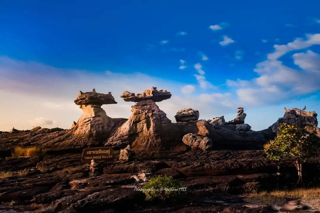
Sao Chaliang is located in Huai Phai Subdistrict, Khong Chiam District, Ubon Ratchathani Province, within Pha Taem National Park under the care of the Department of National Parks, Wildlife and Plant Conservation. The site is best known for its large sandstone pillars shaped like giant mushrooms. These rock formations stand on an open stone terrace surrounded by dry dipterocarp forest and the plateau landscape along the Mekong River. Their unusual shapes show how nature can sculpt stone through water, wind, heat, cool air, erosion, and immense spans of geological time.
For travelers who want to understand Ubon Ratchathani beyond a simple scenic viewpoint, Sao Chaliang is an excellent starting point. The site brings together natural beauty, geology, prehistoric heritage, and the cultural landscape of the Mekong border area in one journey. As visitors approach the rock formations, the first striking sight is the pale sandstone rising from the stone ground, with narrow column-like bodies supporting broad rock slabs above. The pillars look almost deliberately carved, yet every curve, surface, and layer is the result of natural processes working over a very long period.
The name “Sao Chaliang” is commonly explained as being derived from “Sa Liang,” a local term associated with stone pillars. The name suits the landscape perfectly because the sandstone forms stand like natural columns on the rocky terrace. Each pillar has a slightly different base, body, and cap depending on the hardness of the stone, the original rock structure, and the way erosion has acted on it. When viewed closely, the surfaces reveal layered patterns, grains of sand, pebbles, and mineral textures that record the environmental conditions of the past.
Geologically, Sao Chaliang was formed through weathering and erosion of sandstone layers with unequal resistance. Harder layers resisted erosion more effectively and remained as broad cap rocks, while softer layers were worn away more quickly by water, wind, rain, and changing weather. Over time, the softer middle sections became narrower, creating the column-like bodies beneath the broader tops. This makes Sao Chaliang a clear example of sandstone pillar landforms and shows the relationship between rock layering, natural fractures, mineral composition, and long-term erosion.
Traditional explanations of Sao Chaliang often describe the formations as being associated with two sandstone ages: Cretaceous sandstone of around 130 million years in the upper cap-like section and older dinosaur-era sandstone of around 180 million years in the lower pillar section. This helps visitors understand that Sao Chaliang is not a recently formed rock feature, but part of a long geological story involving sandstone that is hundreds of millions of years old. When considered together with the scientific explanation of uneven erosion, the site becomes a natural record of both rock structure and time.
The formation process began with sandstone beds lying horizontally or almost horizontally. Each layer contained different grains, minerals, and cementing materials, which made some layers stronger than others. Natural fractures allowed rainwater and surface runoff to enter the rock. Heat during the day, cooler temperatures at night, wind, and water gradually widened cracks and removed weaker stone. Erosion worked both vertically and horizontally. The weaker parts were carried away, while the more durable parts remained. Over a long span of time, this created the mushroom-shaped pillars that stand on the stone terrace today.
The rock layers at Sao Chaliang make the site especially valuable as an outdoor learning area. The lower part acts as the base, the middle part forms the narrower supporting column, and the upper part spreads outward like an umbrella or mushroom cap. Visitors walking around the site can see that each pillar has its own shape. Some are taller, some are lower, some have broad cap rocks, and some appear as if a large slab has been balanced in place. In reality, these forms are the product of natural geological mechanisms rather than human arrangement.
From a travel perspective, Sao Chaliang is easy to visit compared with many other natural sites inside the national park. Most visitors can spend a short time walking, taking photographs, and enjoying the scenery. However, those who want a deeper experience should move slowly, observe the layers, look at the eroded surfaces, and study the surrounding vegetation. The area has an open forest atmosphere with low trees and hardy plants growing on and around the rocky terrace. This environment matches the broader character of Pha Taem National Park, where rocky plateaus, cliffs, dry dipterocarp forest, and Mekong views shape the travel experience.
Sao Chaliang is also part of the main travel route through Pha Taem National Park. It is located about 1–1.5 km before Pha Taem Cliff, making it easy to combine both places in a half-day or full-day trip. Travelers can start at Sao Chaliang to understand the sandstone landscape, then continue to Pha Taem Viewpoint and the prehistoric rock painting trail. The rock paintings along the cliff wall include images of people, animals, hands, geometric forms, and fishing tools, reflecting ancient human activity along the Mekong. This combination makes Pha Taem National Park a rare place where geological heritage and human history can be experienced together.
Pha Taem Cliff near Sao Chaliang is famous as a sunrise viewpoint because it lies on the eastern edge of Thailand near the Mekong River. Many travelers arrive before dawn to see the first light of the day, then continue to Sao Chaliang or the prehistoric painting trail while the weather is still comfortable. This route works well because the rocky plateau can become hot during midday, especially in the dry season. Starting early gives visitors more time, better light, and a more pleasant walking experience.
Sao Chaliang is also a rewarding photography location. The strongest visual element is the distinctive mushroom-like shape of the sandstone. Wide-angle images can capture the rock pillars with the sky and open forest, medium-distance images show the stone layers and the sculptural form, and close-up shots reveal textures, grains, and erosion marks. Morning and late afternoon light add depth to the rocks and create better shadows. At night, Pha Taem National Park is also recognized as a suitable area for stargazing and astrophotography because of its open rocky terrain, wide sky views, and reduced light disturbance.
Important areas to understand when visiting Sao Chaliang include the rock pillar terrace, parking area, short nature walking route, road connection to Pha Taem, visitor center, Mekong River viewpoint, camping area, accommodation zone, and routes toward waterfalls and other natural attractions. These zones help travelers plan more efficiently. Those with limited time can focus on Sao Chaliang, Pha Taem Viewpoint, and the prehistoric rock paintings. Travelers with more time can add Soi Sawan Waterfall, Saeng Chan Waterfall, the Two-Colored River viewpoint, and Wat Tham Khuha Sawan in Khong Chiam.
Getting There is convenient by private car or rental car. From Ubon Ratchathani city, take Highway 217 toward Phibun Mangsahan District, continue on Highway 2222 toward Khong Chiam District, then use the Khong Chiam–Si Mueang Mai route before entering Highway 2112 toward Pha Taem National Park. Sao Chaliang is located about 1.5 km before Pha Taem Cliff. The road is paved and accessible for general travelers, making the site suitable for families, photographers, cultural travelers, and visitors interested in nature without a demanding trek.
For travelers starting from Khong Chiam, the route is shorter and works well as a morning trip. Visitors can drive up to Pha Taem National Park, stop at Sao Chaliang, continue to Pha Taem Cliff, and visit the visitor center. Those traveling from Ubon Ratchathani city should allow more time because the distance to the national park is longer. Leaving early helps avoid rushing and gives enough time to enjoy the park before returning to Khong Chiam for riverside food or accommodation by the Mekong.
The admission fee for Sao Chaliang is part of the Pha Taem National Park entrance fee. Thai visitors pay 40 Baht for adults and 20 Baht for children. Foreign visitors pay 200 Baht for adults and 100 Baht for children. After paying the entrance fee, travelers can visit the main accessible areas of the park according to national park regulations. Visitors should keep their ticket while inside the park and check park announcements before traveling to seasonal trails, waterfalls, or areas that may be temporarily closed for conservation or safety management.
The best time to visit Sao Chaliang is in the morning or late afternoon, when the temperature is more comfortable and the light is better for photography. The rainy season and early cool season bring fresher greenery to the area, while the cool season is excellent for sunrise viewing, stargazing, and outdoor walking. The hot season is still suitable for a visit, but travelers should bring drinking water, a hat, sunglasses, and shoes with good grip because the stone terrace can become hot and uneven in places.
Responsible travel is essential at Sao Chaliang. Visitors should not climb onto the rock pillars or cap stones, scratch or write on the rock surface, knock the stone, remove natural materials, or leave trash behind. These rock formations took an extremely long time to form, and preserving their condition is a shared responsibility. Respectful travel allows the site to remain both a natural classroom and a meaningful attraction for future visitors.
For families traveling with children, Sao Chaliang is a valuable outdoor classroom. Children can clearly see real examples of erosion, rock layers, sandstone pillars, and geological time. The mushroom-shaped rocks make scientific ideas easier to understand. Parents can explain how rainwater, wind, rivers, heat, cool air, and the changing surface of the Earth work together to reshape stone over time. This makes the visit both enjoyable and educational.
For in-depth travelers, Sao Chaliang should be seen as more than a photo spot. It is evidence of natural processes connected to the wider geological character of lower northeastern Thailand. The sandstone layers, cliffs, rocky terraces, dry forest, waterfalls, Mekong viewpoints, and prehistoric paintings all form part of the same regional story. Visiting Sao Chaliang helps travelers understand how one destination can hold natural beauty, scientific value, cultural memory, and conservation importance at the same time.
The atmosphere around Sao Chaliang is quiet, open, and spacious. It suits travelers who want to step away from crowded urban areas and experience a landscape shaped by time. The rocky terrace and open forest allow broad views of the sky, while the stone pillars stand calmly in the sunlight. This simplicity is part of the site’s appeal. There are no large modern structures overwhelming the natural form of the rocks, so visitors can still appreciate the original landscape clearly.
A trip to Sao Chaliang can also be combined with food and accommodation in Khong Chiam. After visiting the national park, travelers can go down to the district center for riverside restaurants, Mekong fish dishes, Isan food, and local cuisine. Those who stay overnight can choose national park accommodation, riverside resorts, small hotels, guesthouses, or lodgings near the Mekong. Staying in Khong Chiam allows travelers to enjoy sunrise at Pha Taem and visit Sao Chaliang without rushing.
In conclusion, Sao Chaliang in Ubon Ratchathani is a natural attraction worth visiting because it combines striking sandstone pillars, geological learning, access to Pha Taem National Park’s major highlights, and the deep landscape of the Mekong frontier. Visitors see beauty that was not built by human hands but formed by stone, water, wind, weather, and millions of years. It remains one of the most memorable natural landmarks in Ubon Ratchathani Province.
| Name | Sao Chaliang, Pha Taem National Park |
| Thai Name | เสาเฉลียง อุทยานแห่งชาติผาแต้ม |
| Location | Huai Phai Subdistrict, Khong Chiam District, Ubon Ratchathani Province |
| Address | Pha Taem National Park, Huai Phai Subdistrict, Khong Chiam District, Ubon Ratchathani 34220, Thailand |
| Highlights | Natural mushroom-shaped sandstone pillars formed by long-term erosion from water, wind, rain, and weathering |
| History / Geological Period | Associated with ancient sandstone layers hundreds of millions of years old, traditionally explained as an upper Cretaceous sandstone section of around 130 million years and a lower dinosaur-era sandstone section of around 180 million years |
| Name Origin | The name “Sao Chaliang” is commonly explained as being derived from “Sa Liang,” meaning stone pillar, matching the form of the sandstone columns |
| Distinctive Features | Narrow sandstone columns supporting broad cap rocks, created by uneven erosion of hard and soft rock layers |
| Travel Information | From Ubon Ratchathani city, take Highway 217 to Phibun Mangsahan, continue on Highway 2222 to Khong Chiam, then follow the Khong Chiam–Si Mueang Mai route and Highway 2112 toward Pha Taem National Park. Sao Chaliang is about 1.5 km before Pha Taem Cliff. |
| Current Status | Open to visitors within Pha Taem National Park |
| Open Days | Daily |
| Opening Hours | 04:30 – 19:30 |
| Fees | Thai Visitors: Adult 40 Baht, Child 20 Baht / Foreign Visitors: Adult 200 Baht, Child 100 Baht |
| Facilities | Visitor center, park accommodation, camping ground, toilets, shower rooms, restaurant, souvenir shop, and meeting room within the national park area |
| Main Areas / Zones | Sao Chaliang rock terrace, parking area, short nature trail, visitor center, Pha Taem viewpoint, prehistoric rock painting trail, Mekong River viewpoint, camping area, and stargazing area |
| Caretaker | Pha Taem National Park, Department of National Parks, Wildlife and Plant Conservation |
| Main Contact Number | 045-252581, 089-8105532 |
| Official Website / Official Page | Pha Taem National Park Official Page and the Department of National Parks accommodation booking system |
| Nearby Tourist Attractions | 1. Pha Taem Cliff And Mekong Viewpoint, about 2 km 2. Pha Taem Prehistoric Rock Paintings, about 2 km 3. Pha Taem National Park Visitor Center, about 2 km 4. Soi Sawan Waterfall, about 25 km 5. Two-Colored River Viewpoint, Khong Chiam, about 20 km 6. Wat Tham Khuha Sawan, about 20 km 7. Kaeng Tana National Park, about 28 km |
| Nearby Restaurants | 1. Lung Nuat Pha Taem Restaurant, about 3 km, Tel. 096-172-3512 2. Khrua Khong Chiam, about 20 km, Tel. 045-351027, 062-829-3697 3. Pae Lam Khong, about 20 km, Tel. 091-918-9168 4. Pornnapa Pla Chum Khong Chiam, about 20 km, Tel. 080-162-2469 5. Lap Pla Khong Chiam Restaurant, about 21 km, Tel. 045-351283 6. Chandara Khong Chiam, about 20 km, Tel. 098-242-4464 |
| Nearby Accommodations | 1. Pha Taem National Park Accommodation And Camping Ground, about 2 km, Tel. 045-252581 2. Pha Taem & Kaeng Phisamai Riverside, about 12 km, Tel. 093-321-9889 3. Khong Chiam Orchid Riverside Resort, about 20 km, Tel. 098-916-8771 4. Tohsang Heritage Khongjiam, about 20 km, Tel. 081-860-5905, 045-351174-6 5. Sedhapura By Tohsang, about 20 km, Tel. 081-860-5905, 045-351174-6 6. Khong Chiam Hotel, about 20 km, Tel. 045-351074, 086-468-7431 |
Frequently Asked Questions (FAQ)
Q: Is Sao Chaliang in Ubon Ratchathani open every day?
A: Yes. Sao Chaliang is open daily within Pha Taem National Park from 04:30 to 19:30.
Q: Is there an admission fee for Sao Chaliang?
A: Yes. The site uses the Pha Taem National Park entrance fee. Thai visitors pay 40 Baht for adults and 20 Baht for children. Foreign visitors pay 200 Baht for adults and 100 Baht for children.
Q: How was Sao Chaliang formed?
A: Sao Chaliang was formed by long-term erosion of sandstone. Harder rock layers remained as broad cap rocks, while softer layers were worn away, creating narrow pillar-like bodies beneath them.
Q: How far is Sao Chaliang from Pha Taem Cliff?
A: Sao Chaliang is about 1–1.5 km before Pha Taem Cliff, so both places can be visited easily in the same trip.
Q: What is the best time to visit Sao Chaliang?
A: Morning and late afternoon are the best times because the weather is more comfortable and the light is ideal for photography. Many travelers combine the visit with sunrise at Pha Taem Cliff.
Q: How do travelers get to Sao Chaliang from Ubon Ratchathani city?
A: Drive from Ubon Ratchathani city on Highway 217 toward Phibun Mangsahan, continue on Highway 2222 toward Khong Chiam, then follow the route to Highway 2112 and Pha Taem National Park.
Q: Is Sao Chaliang suitable for children?
A: Yes. It is a useful outdoor learning site where children can clearly see sandstone layers, erosion, and unusual rock formations. Adults should ensure children do not climb the rocks or leave the walking area.
Q: Are there restaurants and accommodations near Sao Chaliang?
A: Yes. There are restaurants near Pha Taem and in Khong Chiam, as well as national park accommodation, camping areas, riverside resorts, hotels, and guesthouses. Verified options with distances and phone numbers are listed in the summary table above.
 Category: ●Nature and Wildlife
 Group: ●Other natural attractions
Last Update : 2 MonthAgo
 Last Update : 2 MonthAgo
 Click to Access the Navigation Map GPS
Sao Chaliang Map
Recommend

 Art, Culture and Heritage
 Historical Sites and Monuments(5)
 Landmarks and Memorials(2)
 Royal Palace(1)
 Art, Craft Centres, Tradition(7)
 Museums(3)
 Places of Worship
 Temple(37)
 Other Sacred Sites(4)
 Research and Development
 Royal Project(2)
 Suburban Living
 Village, Community(2)
 Local Market(4)
 National Parks and Marine Reserves(5)
 Mountain (Doi)(6)
 Dam, Reservoir, Lake(8)
 Waterfalls(12)
 Hot Springs(1)
 Caves(2)
 River, Canal(11)
 Bays and Beaches(8)
 Islands(2)
Other natural attractions(6)
Islands(2)
Other natural attractions(6)
 Entertainment and Agricultural
 Zoos and Aquariums(1)
 Animal camps and shows(1)
 Farms, Parks and Ecotourism(1)


