
lovethailand home >Northeastern Travel Attractions >Ubon Ratchathani Travel Attractions >Pho Sai >Song Khon > Hat Salueng
TL;DR: Hat Salueng, Ubon Ratchathani attractions : Nature and Wildlife, Bays and Beaches.
Hat Salueng
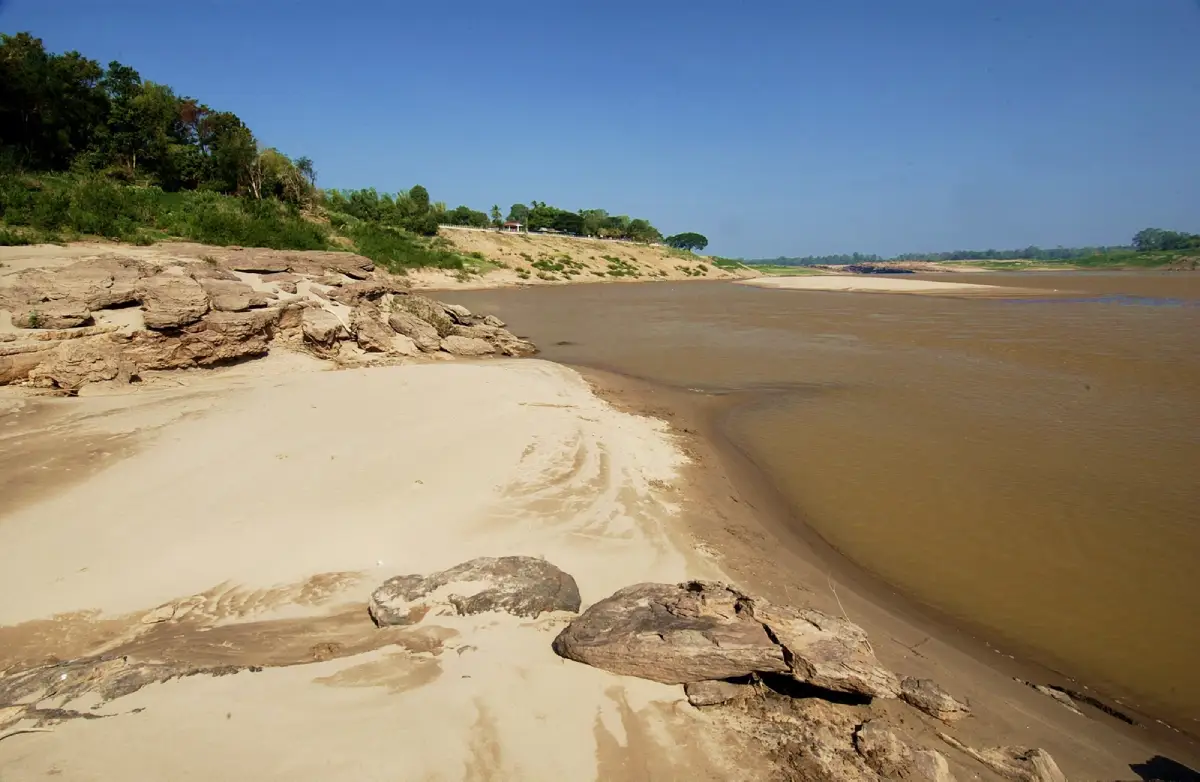
Open Days: Accessible daily depending on Mekong River water levels and seasonal conditions
Opening Hours: No ticketed gate-style opening hours; best visited from daytime to early evening, especially during the dry season from January to May
Hat Salueng in Ubon Ratchathani is a white sand beach along the Mekong River at Ban Song Khon, Song Khon Subdistrict, Pho Sai District, about 115 km from Ubon Ratchathani city via Highway 2050. Its highlights include fine white sand appearing during the dry season, views across the Mekong to Laos, Songkran water-play atmosphere, boat access to Sam Phan Bok, riverside restaurants, accommodations, souvenir shops, cart service to the beach, and onward routes to Hat Hong, Lan Hin Si, Pha Chan, Sao Chaliang, and Khong Chiam.
Hat Salueng in Ubon Ratchathani is one of the best-known Mekong riverside attractions in Pho Sai District. Located at Ban Song Khon, Song Khon Subdistrict, Pho Sai District, Ubon Ratchathani Province, about 115 km from the provincial city along Highway 2050 on the Ubon Ratchathani – Trakan Phuet Phon – Pho Sai route, this destination is famous for its fine white sand beach that appears clearly during the dry season. When the Mekong River level drops, the hidden sandy bank emerges and turns the area into a spacious riverside beach for relaxation, seasonal water play, food, photography, and boat trips to Sam Phan Bok and other Mekong attractions.
Hat Salueng has long been known by local people and travelers as a lively freshwater beach along the Mekong River. It is especially popular during the dry season and the Songkran period, when the white sand becomes wide and visible. Families, young travelers, local residents, and visitors from nearby districts gather here to play in the water, eat by the river, take photographs, and enjoy the festive atmosphere. The beach is not only a natural attraction. It is also a community space with restaurants, shops, souvenirs, accommodation, boats, local guides, and services that support travelers exploring the Mekong route.
The origin of the name Hat Salueng gives the place a memorable local identity. According to local tradition, in the past a one-salueng coin was valuable enough to buy a buffalo. During Songkran, people challenged one another to walk or run the full length of the beach, about 860 meters, at midday in mid-April without stopping. Anyone who succeeded would receive a reward of one salueng. No one ever completed the challenge, so local people came to call the place Hat Salueng. The name therefore preserves a story about the heat of the sand, the length of the beach, the Songkran season, and the playful spirit of the community.
The landscape of Hat Salueng is shaped directly by the Mekong River. The beach is most clearly visible from January to May, during the dry season in northeastern Thailand, when the river level drops and the fine white sand appears along the bank. The scenery includes a broad sandy foreground, the wide Mekong River, and the Lao side of the river in the distance. This makes Hat Salueng more than a beach. It is also a border landscape where visitors can experience the geography of the Thai-Lao Mekong region in a simple and direct way.
The greatest charm of Hat Salueng is that visitors can physically walk onto the sand and feel the dry-season Mekong environment. In the morning or at times when the sun is not too strong, the sand is pleasant for walking, photography, and river viewing. From the beach, travelers can look across to Laos, see boats along the river, and enjoy the open feeling of the Mekong. The place offers a calmer and more accessible riverside experience than more rugged rock formations or difficult natural sites.
During Songkran, Hat Salueng becomes one of the most animated places in Pho Sai District. Local people, families, and young visitors gather for water play and riverside leisure. This seasonal energy is closely connected with the name story of Hat Salueng and with the dry-season appearance of the beach. The Songkran atmosphere gives the destination a social and cultural dimension. It is not merely a scenic sandbank; it is a place where local people meet, celebrate, and keep a riverside tradition alive.
Hat Salueng is also an excellent viewpoint toward Laos. The Mekong River here functions as a natural border, and on clear days visitors can see across the water to the Lao side. The openness of the beach and the width of the river create a clear borderland landscape. For foreign travelers, this is a valuable way to understand Ubon Ratchathani as a Mekong province. The experience is different from visiting temples, city markets, or festival venues because it reveals the province through water, sand, boat routes, and border geography.
Main activities at Hat Salueng include walking on the white sand, relaxing by the Mekong, playing in the water when conditions are safe, eating at local restaurants, buying souvenirs, taking photographs, and starting boat trips from Hat Salueng Pier. The beach plays an important role as both a destination and a gateway. Travelers who want to visit Sam Phan Bok can begin from Hat Salueng and experience the Mekong River by boat before reaching the famous rock formations.
The boat route from Hat Salueng is one of the most important experiences in the area. Depending on water conditions, route selection, and local operators, travelers can connect to several Mekong attractions such as Pha Phaniang, Don Klang, Kaeng Noi, Kaeng Khon Yai, Don Mak Kluea, Pak Bong, Hin Kong Khao, Khan Nok Iang, Tham Nang Tho Huk, Sam Phan Bok, Sila Laeng, Hat Hong, and Lan Hin Si. Each stop has a different character. Some are rapids, some are sandbanks, some are rock fields, and some are seasonal Mekong formations.
Sam Phan Bok is the most popular onward destination from Hat Salueng. Ban Song Khon is well positioned for travelers who want to continue to Sam Phan Bok by boat or by road. Sam Phan Bok is known for thousands of natural rock holes carved by the Mekong current during the flood season. When the water recedes in the dry season, the rock landscape appears above the surface and creates the famous “Grand Canyon of the Mekong.” Starting from Hat Salueng gives the journey more depth because travelers can see the river route before arriving at the main rock field.
Hat Hong and Lan Hin Si are also worthwhile for travelers who have enough time. Hat Hong is known for its large fine-sand formation with a miniature desert-like character, while Lan Hin Si is known for colorful and polished rock surfaces along the Mekong. Together with Hat Salueng and Sam Phan Bok, these places create a varied Mekong route: white sand, rock holes, sand dunes, colored rock fields, boats, and riverside communities.
Getting There from Ubon Ratchathani city is straightforward but requires time. Take Highway 2050 on the Ubon Ratchathani – Trakan Phuet Phon – Pho Sai route for about 115 km, then continue toward Song Khon Subdistrict and Ban Song Khon. A private car, rental car, or chartered van is the most practical option because the destination is far from the city and public transport is less flexible. Travelers without their own vehicle should plan the return journey, accommodation, and onward transfer to Sam Phan Bok or Khemarat in advance.
From Pho Sai District town, travelers can continue toward Song Khon Subdistrict and Ban Song Khon. The distance is shorter and more convenient for visitors already staying in Pho Sai or near Sam Phan Bok. From Khemarat, travelers can follow the Mekong-side route toward Song Khon and Hat Salueng, making it possible to combine Khemarat Walking Street, riverside viewpoints, Sam Phan Bok, and Hat Salueng into one connected Mekong itinerary.
Facilities at Hat Salueng are relatively strong for a seasonal Mekong beach. The area has accommodation, restaurants, shops, souvenir stalls, chartered boats, local guides, and cart services for travelers who want an easier way to move between the upper area and the beach. These services are helpful for families, elderly visitors, and travelers carrying bags or equipment. Restaurants and accommodations nearby also make Hat Salueng a practical base for visiting Sam Phan Bok in the morning or late afternoon.
Food is an important part of the Hat Salueng experience. The area is known for local Mekong-style dining, including river fish, Isan dishes, spicy salads, grilled fish, papaya salad, and other shared dishes suitable for groups. Eating here is not simply a meal. It is part of the riverside travel atmosphere. Visitors can sit near the river, watch boats, see the movement of travelers, and enjoy the life of Ban Song Khon community.
Accommodation around Hat Salueng and Song Khon is useful for travelers planning to visit Sam Phan Bok. Because accommodation near Sam Phan Bok can be limited, many travelers use Hat Salueng, Song Khon, or nearby Pho Sai as a base. Staying in this area makes it easier to arrange boat trips, see the Mekong in the evening or early morning, and experience local riverside life rather than rushing back to Ubon Ratchathani city on the same day.
The best travel season is from January to May, when the Mekong River level is low and the beach is most visible. April is especially lively because of Songkran, but it is also hotter and more crowded. Travelers who prefer a quiet atmosphere should visit on weekdays or early in the morning during the dry season. Travelers who want to see the festive local atmosphere should visit during Songkran or long holidays, while allowing extra time for traffic, parking, food, and boat services.
Hat Salueng is good for several kinds of photography. Visitors can photograph the white sand beach, the Mekong River, Laos across the river, boats at the pier, Songkran water play, cart services, local restaurants, souvenirs, and family travel scenes. Morning and late afternoon usually give softer light than midday. The wide river, bright sand, and open sky work well for landscape photography and travel portraits.
Travelers who want to enter the water should pay close attention to safety. Although Hat Salueng is popular for seasonal water play, the Mekong River is a large natural river with changing depth and current. Visitors should enter only suitable and safe areas, avoid unknown depths, and keep children under close adult supervision at all times. Safety should always come before photographs or play.
For elderly travelers and families with small children, the cart service is useful because walking on sand can be tiring, especially during hot weather. Visitors should bring a hat, umbrella, drinking water, sun protection, and footwear suitable for sand. During Songkran and long holidays, it is wise to allow more time for crowds, boat queues, parking, and restaurants.
For foreign travelers, Hat Salueng is a strong introduction to Mekong-based tourism in Thailand. It is a freshwater beach shaped by river seasons rather than a sea beach. A visit reveals the relationship between the Mekong River, the Thai-Lao border, local boat routes, Isan food, community services, sandbanks, rapids, and rock formations. It is suitable for travelers who want a deeper understanding of Ubon Ratchathani beyond the city and major temples.
Hat Salueng is also a practical starting point for a longer Mekong route. Travelers can begin in Ubon Ratchathani city, travel to Pho Sai, stop at Hat Salueng, take a boat to Sam Phan Bok, continue to Hat Hong or Lan Hin Si, and then drive onward to Khemarat, Pha Chan, Sao Chaliang, or Khong Chiam. This route makes Hat Salueng an effective gateway to the northern Mekong side of Ubon Ratchathani.
At the community level, Hat Salueng reflects the role of Ban Song Khon and Ban Pak Kalang as service centers for Mekong tourism. The community supports visitors through boats, food, accommodation, souvenirs, and local knowledge. As Sam Phan Bok became more widely known, Hat Salueng also became more important as a starting point for river journeys. Visitors who begin here experience both the natural landscape and the community system that makes Mekong travel possible.
There is generally no ticket-style admission fee for the beach area. Main expenses come from optional services such as chartered boats, cart service, food, drinks, accommodation, souvenirs, and local activities. Boat fees vary according to route, distance, timing, and operator. Travelers should ask directly at Hat Salueng Pier before starting a boat trip.
Because Hat Salueng depends on Mekong water levels, the exact shape and width of the beach can vary by year. Even during the dry season, access points, boat availability, sand conditions, and safe water areas can change. Travelers should treat the destination as a seasonal natural site and rely on local operators for water-route decisions, especially when visiting Sam Phan Bok or other rock and rapid areas.
Keeping the area clean is essential. Hat Salueng is both a natural beach and a community livelihood area. Visitors should place waste in proper locations, avoid throwing plastic or food waste into the river, respect local operators, and ask permission before photographing people, shops, or community activities closely. Responsible travel helps keep Hat Salueng beautiful for local residents and future visitors.
In conclusion, Hat Salueng is a complete Mekong riverside destination combining nature, community, food, accommodation, and river routes. Its highlights include fine white sand during the dry season, the legend behind its name, lively Songkran water play, views toward Laos, and its role as a boat gateway to Sam Phan Bok. Travelers seeking a deeper Ubon Ratchathani experience should spend time here rather than treating it only as a passing stop, because Hat Salueng clearly reveals the connection between the Mekong River, border communities, river travel, and local leisure.
| Name | Hat Salueng, Ubon Ratchathani |
| Location | Ban Song Khon, Song Khon Subdistrict, Pho Sai District, Ubon Ratchathani Province |
| Address | Ban Song Khon / Ban Pak Kalang, Song Khon Subdistrict, Pho Sai District, Ubon Ratchathani 34340 |
| Highlights | Fine white sand beach along the Mekong River, approximately 860 meters long, views toward Laos, Songkran water play, boat gateway to Sam Phan Bok, restaurants, accommodation, souvenirs, and cart service to the beach |
| History | A long-standing Mekong riverside leisure area of Ban Song Khon and Pho Sai District, linked with a local story about a one-salueng reward for anyone who could run or walk the 860-meter beach at midday in April without stopping |
| Name Origin | The name Hat Salueng comes from the local challenge involving a one-salueng reward. No one completed the challenge, so the beach became known as Hat Salueng. |
| Distinctive Features | A seasonal freshwater beach along the Mekong River, clearly visible during the dry season, with fine white sand, open river views, and a clear view across to Laos |
| Travel Information | From Ubon Ratchathani city, take Highway 2050 on the Ubon Ratchathani – Trakan Phuet Phon – Pho Sai route for about 115 km, then continue to Song Khon Subdistrict and Ban Song Khon. Private car, rental car, or chartered van is recommended. |
| Current Status | Open as a seasonal natural attraction of Song Khon Subdistrict, Pho Sai District, and an important boat starting point for Sam Phan Bok and other Mekong attractions |
| Open Days | Accessible daily depending on Mekong River water levels and seasonal conditions |
| Opening Hours | No ticketed gate-style opening hours; best visited from daytime to early evening, especially during the dry season from January to May |
| Fees | No general admission ticket for the beach area. Chartered boats, cart service, food, drinks, accommodation, souvenirs, and local activities are charged by individual providers. |
| Facilities | Restaurants, shops, souvenir stalls, accommodations, pier, chartered boats, local guides, cart service to the beach, Mekong viewpoints, and visitor services in Song Khon community |
| Main Areas / Zones | 1. White sand Mekong beach zone 2. Dry-season water play and relaxation zone 3. Laos-facing viewpoint zone 4. Hat Salueng Pier zone 5. Beach cart service zone 6. Restaurant, shop, and souvenir zone 7. Accommodation and local resort zone 8. Boat route connection zone to Sam Phan Bok, Hat Hong, and Lan Hin Si |
| Caretaker | Song Khon Subdistrict Administrative Organization, Ban Song Khon community, boat operators, restaurants, accommodations, shops, and local tourism service groups |
| Main Contact Number | Song Khon Subdistrict Administrative Organization Tel. 045-251-891 Hat Salueng Pier Tel. 090-186-1220 |
| Official Website / Local Information Sources | Song Khon Subdistrict Administrative Organization website CBT Thailand / DASTA website Thailand Tourism Directory |
| Nearby Tourist Attractions | 1. Hat Salueng Pier, about 0.2 km, Tel. 090-186-1220 2. Pak Bong, the narrow Mekong point, about 3 km by boat 3. Hin Hua Phaniang, about 4 km by boat 4. Sam Phan Bok, about 4 km by boat 5. Hat Hong, about 6 km by boat 6. Lan Hin Si / Hat Hin Si, about 8 km by boat 7. Khemarat Walking Street, about 50 km 8. Pha Chan, Pho Sai District, about 55 km |
| Nearby Restaurants | 1. Chom Khong Resort – Hat Salueng, about 0.5 km, Tel. 081-879-4689 2. Hat Salueng Community Restaurants And Food Rafts, about 0.5 km 3. Ban Song Khon Community Restaurants, about 1 km 4. Khemarat Kung Sod Kung Phao, about 50 km, Tel. 089-425-0457, 088-580-8539 5. Shabu Indy Khemarat, about 50 km, Tel. 080-468-5164 6. Por Rak Khemarat, about 50 km, Tel. 082-366-4499 7. Rotniyom Kung Sod Khemarat, about 50 km, Tel. 094-443-7377 |
| Nearby Accommodations | 1. Chom Khong Resort – Hat Salueng, about 0.5 km, Tel. 081-879-4689 2. Meena Resort, Song Khon Subdistrict, about 3 km, Tel. 083-100-3156 3. Na Fang Khong Resort, about 5 km, Tel. 083-742-6888 4. Plaifah Resort Ubon, Sam Phan Bok, about 12 km, Tel. 085-495-2373 5. Ban Song Khon Community Homestays And Local Accommodations, about 1 km 6. Accommodations In Pho Sai District Town, about 20 km 7. Accommodations In Khemarat Town, about 50 km |
Frequently Asked Questions (FAQ)
Q: Where is Hat Salueng located?
A: Hat Salueng is located at Ban Song Khon, Song Khon Subdistrict, Pho Sai District, Ubon Ratchathani Province, about 115 km from Ubon Ratchathani city via Highway 2050 on the Ubon Ratchathani – Trakan Phuet Phon – Pho Sai route.
Q: When is the best time to visit Hat Salueng?
A: The best time to visit is from January to May, when the Mekong River level drops and the fine white sand beach becomes clearly visible.
Q: Is there an admission fee for Hat Salueng?
A: There is no general admission ticket for the beach area. Visitors pay separately for services such as chartered boats, cart service, food, drinks, accommodation, and souvenirs.
Q: Can visitors swim at Hat Salueng?
A: Visitors can enter the water during the dry season only in safe areas with suitable water conditions. Since the Mekong River is a large natural river, depth and current must be checked, and children must always be supervised.
Q: How is Hat Salueng connected with Sam Phan Bok?
A: Hat Salueng is an important boat starting point for trips to Sam Phan Bok and other Mekong attractions such as Pak Bong, Hin Hua Phaniang, Hat Hong, and Lan Hin Si.
Q: Are there restaurants and accommodations at Hat Salueng?
A: Yes. The Hat Salueng, Ban Song Khon, and nearby areas have restaurants, shops, souvenir stalls, accommodations, resorts, and local services that support Sam Phan Bok and Mekong River travel.
Q: Why is the place called Hat Salueng?
A: The name comes from a local story about a one-salueng reward for anyone who could walk or run the 860-meter beach at midday in April without stopping. No one succeeded, so local people named the place Hat Salueng.
Q: Is Hat Salueng suitable for foreign travelers?
A: Yes. It is suitable for foreign travelers who want to experience a freshwater Mekong beach, Thai-Lao border scenery, local riverside communities, boat trips to Sam Phan Bok, Isan food, and a deeper view of Ubon Ratchathani.
 Category: ●Nature and Wildlife
 Group: ●Bays and Beaches
Last Update : 3 MonthAgo
 Last Update : 3 MonthAgo
 Click to Access the Navigation Map GPS
Hat Salueng Map
Recommend

 Art, Culture and Heritage
 Historical Sites and Monuments(5)
 Landmarks and Memorials(2)
 Royal Palace(1)
 Art, Craft Centres, Tradition(7)
 Museums(3)
 Places of Worship
 Temple(37)
 Other Sacred Sites(4)
 Research and Development
 Royal Project(2)
 Suburban Living
 Village, Community(2)
 Local Market(4)
 National Parks and Marine Reserves(5)
 Mountain (Doi)(6)
 Dam, Reservoir, Lake(8)
 Waterfalls(12)
 Hot Springs(1)
 Caves(2)
 River, Canal(11)
Bays and Beaches(8)
 Islands(2)
 Other natural attractions(6)
 Entertainment and Agricultural
 Zoos and Aquariums(2)
 Animal camps and shows(1)
 Farms, Parks and Ecotourism(1)
 Waterpark(1)
 Travel Articles, Recipes
 Travel Review, Food Review(1)


