
lovethailand home >Northeastern Travel Attractions >Mukdahan Travel Attractions >Khamcha-i >Kham Bok > Phu Pha Kut
TL;DR: Phu Pha Kut is located at Mountain forest in Kham Bok Subdistrict, Khamcha-i District, extending toward Phu Wong Subdistrict, Nong Sung District, Mukdahan Province, open Daily; advance coordination with the local caretakers is recommended, hours 08.00 – 17.00.

Phu Pha Kut
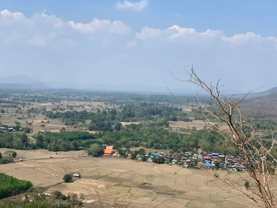
Open Days: Daily; advance coordination with the local caretakers is recommended
Opening Hours: 08.00 – 17.00
Phu Pha Kut in Mukdahan Province, also written locally as Phu Phak Kut, is a mountain forest, protected medicinal-plant area, ecological study destination, and Buddhist retreat landscape in Kham Bok Subdistrict, Khamcha-i District. Covering approximately 10,500 rai, the forest extends toward Phu Wong Subdistrict in Nong Sung District and contains plateaus, cliffs, valleys, streams, caves, waterfalls, humid forest, and old-growth trees. Phu Pha Kut is one of Mukdahan’s most important natural medicinal-plant areas. Surveys recorded at least 322 medicinal species, including rare, protected, and locally restricted plants. The destination is particularly suitable for travelers interested in forest trekking, botany, traditional healing knowledge, community conservation, meditation history, and quiet overnight nature experiences arranged with local caretakers.
Phu Pha Kut lies west of the communities of Kham Bok. The principal approach is connected with Ban Bak, Moo 1, and the forest road leading toward Wat Phu Pha Kut. The mountain continues toward the administrative boundary with Phu Wong in Nong Sung District. Ecologically, these boundaries do not divide the forest. Hills, watercourses, wildlife habitat, and plant populations continue across both districts. A journey into Phu Pha Kut therefore moves gradually from villages and farmland into slopes, shaded forest, rocky passages, streams, and elevated viewpoints overlooking the surrounding rural landscape.
Part of Phu Pha Kut lies within Tham Pha Nam Thip Non-Hunting Area and the wider Dong Ma-i and Dong Bang-i national forest landscapes. This legal status makes the destination different from an ordinary recreational mountain. Wildlife, forest plants, medicinal resources, and watershed areas are protected. Not every trail is open for unrestricted tourism. Some routes are used for patrolling, fire prevention, religious access, research, or community resource management. Groups planning to trek, study medicinal plants, enter deeper forest, or camp should contact the Kham Bok Subdistrict Administrative Organization, the Phu Pha Kut Forest Protection Unit, or a recognised community guide before arrival.
The national importance of Phu Pha Kut became particularly clear when a medicinal-plant protection plan was established for the period 2008–2010. Surveys documented at least 322 medicinal plant species. A high proportion were considered uncommon in other areas, while no fewer than 12 were identified as locally restricted medicinal species. Protection was not designed only for individual valuable plants. It included the entire ecological system: soil, water, insects, pollinators, wildlife, forest structure, and the knowledge of traditional healers who understand seasons, sustainable harvesting, preparation methods, and the need to preserve parent plants.
Plants recorded in the Phu Pha Kut area include red kwao khrua, a protected medicinal climber, and phak kut chang or mahatsadam, a rare tree fern facing conservation pressure. The forest also contains forest cardamom relatives, hua ya yen, vines, shrubs, roots, ferns, food plants, and trees used in local remedies. This diversity makes Phu Pha Kut a natural genetic reservoir for Mukdahan. The loss of even one part of the forest affects not only the plants growing there but also animals, water, seed dispersal, and community knowledge associated with them.
Visitors must not collect medicinal plants for personal use. Plants with familiar-looking leaves, roots, or fruit can be confused with toxic species. Some medicinal plants are dangerous when the wrong part is used, when the dose is excessive, or when they are combined with modern medicine. Responsible learning involves walking with a guide or knowledgeable community member, observing plants, taking photographs, and recording information without digging roots, cutting stems, peeling bark, or removing seeds. Medical use should be discussed with a qualified practitioner rather than based on a brief forest visit.
The mountain is also called Phu Phak Kut in oral history and accounts connected with forest monks. The name reflects the long association between the mountain and ferns growing in humid environments. Valleys, shaded streams, and water-retaining depressions maintain moisture for longer periods than the surrounding plains, providing suitable conditions for ferns and other shade-loving plants. Phu Pha Kut is the common modern spelling, while Phu Phak Kut continues to appear in religious biographies and local speech.
The terrain consists of relatively level areas alternating with cliffs, slopes, valleys, and ridges. Loam and clay soils retain moisture, while heavy seasonal rainfall feeds streams and wet forest pockets. Different levels of elevation, sunlight, wind, and water create many small habitats within a limited distance. Plants on an exposed ridge differ from those beneath a multi-layered canopy or beside a shaded watercourse. This environmental variation is one of the main reasons so many plant species can survive in the same mountain system.
Descriptions of Phu Pha Kut as rainforest refer to its dense, humid forest character, especially within valleys, stream corridors, and areas where limited sunlight reaches the ground. The broader forest is a mosaic that changes according to elevation and exposure. While walking uphill, travelers can observe differences in tree size, canopy density, ferns, moss, vines, and undergrowth. In the most sheltered sections, large trees form several layers of canopy, maintaining moisture and reducing temperatures close to the forest floor.
The forest contains many large and ancient trees. Local communities often refer to some of the most impressive specimens as “thousand-year-old trees,” expressing their exceptional size, buttress roots, thick trunks, and long presence in the landscape. Not every tree has been individually dated, but the old-growth character of the forest can be recognised through mature canopy structure, large woody vines, tree cavities, and complex root systems. Visitors should view these trees without climbing, cutting, carving, attaching signs, or driving nails into their trunks.
Old trees provide far more than shade. Cavities, branches, bark fissures, and decaying sections offer habitat for birds, insects, reptiles, and small mammals. Fallen leaves produce organic matter that retains moisture and returns nutrients to the soil. Large roots stabilise steep slopes and reduce erosion. When an old tree falls naturally, its wood becomes food and shelter for fungi and decomposers. This continuous cycle makes an established forest ecologically more complex than a young plantation of evenly aged trees.
Phu Pha Kut is also a major watershed landscape. Rain filters through leaves, roots, and forest soil before moving gradually toward channels, streams, and small waterfalls. The forest slows runoff, reduces sediment, and stores moisture longer than a cleared mountain. Communities below benefit through agricultural water, groundwater recharge, cooler local conditions, and reduced erosion during heavy rain. Protecting the forest therefore also protects the community’s water system.
Tham Phra Phrom Waterfall is one of the natural features associated with Phu Pha Kut. The waterfall is most impressive during the rainy season and immediately after periods of rainfall, when water passes through rock and dense forest. Wet rock, changing water levels, and loose material beneath cliffs create serious risks. Visitors must remain on recognised routes, avoid swimming during strong flow, keep away from unstable cliff faces, and never approach an exposed edge solely for photography. A local guide who understands the stream and current conditions should accompany any visit.
Caves and rock shelters across the mountain have given Phu Pha Kut religious importance. Biographies of Thailand’s forest-monk tradition connect the area with Luang Pu Sao Kantasilo, Luang Pu Mun Bhuridatta, and other meditation masters who traveled and practiced within these remote forests. Distance from villages, limited material comfort, and the quiet forest environment made the mountain suitable for disciplined meditation. This history continues through Wat Phu Pha Kut, Wat Tham Champa, Wat Tham Luang Pu Sao, and other forest temples around the range.
Wat Phu Pha Kut is located near Ban Bak, Moo 1, Kham Bok Subdistrict, and provides an important religious access point to the mountain. Mukdahan Province and the Kham Bok Subdistrict Administrative Organization have included the Ban Bak–Wat Phu Pha Kut road in local development planning. Road-surface improvement was advanced in 2025, helping monks, residents, forest officers, and visitors reach the temple more safely. This does not mean that the deeper forest has become a fully developed road attraction. Natural trails, seasonal conditions, and protected zones remain.
Management is shared among the Phu Pha Kut Forest Protection Unit under Tham Pha Nam Thip Non-Hunting Area, the Kham Bok Subdistrict Administrative Organization, the Wat Phu Pha Kut monastic community, village leaders, traditional healers, local conservation groups, and residents around the forest. Each group contributes different knowledge. Forest officers manage law enforcement, wildlife, patrols, and fires, while residents understand trails, water, medicinal plants, seasonal changes, and the historical relationship between the mountain and surrounding communities.
In 2025, the Kham Bok Subdistrict Administrative Organization implemented a project to develop a medicinal-plant learning route for communities in Moo 1–6. The project confirms the continuing role of Phu Pha Kut as a living learning landscape and community conservation destination. A recognised route helps reduce trampling, organises visitor movement, and allows plants to be interpreted systematically. It remains a protected forest rather than an unrestricted botanical garden. Signs and instructions must be followed, and no specimen should be removed.
For planning purposes, the destination can be understood as a series of connected zones. The first is Ban Bak and the Kham Bok community, where groups contact guides, obtain supplies, and confirm conditions. The second is Wat Phu Pha Kut and the religious access area. The third is the medicinal-plant study route. The fourth is humid forest with mature trees and dense canopy. The fifth includes streams, caves, and Tham Phra Phrom Waterfall. The sixth contains cliffs, viewpoints, and exposed areas. The final zone includes ranger operations and restricted conservation sections that require authorisation.
Walking in Phu Pha Kut is genuine forest trekking, not a level park path. Routes contain loam, clay, roots, stones, steep ground, wet surfaces, and cliff sections. Distance and difficulty vary according to the intended destination, weather, and routes opened by caretakers. Inexperienced hikers should begin with a shorter learning route and remain with a guide. Animal tracks and unmarked side paths must not be used as shortcuts because they can lead into valleys, dense vegetation, wildlife habitat, or hazardous terrain.
The rainy season, approximately May to October, brings the forest’s deepest colours. Streams and waterfalls carry more water, while ferns, mosses, fungi, and ground plants become highly visible. This is an excellent period for studying humid forest ecology and photography, but it is also the most slippery and unpredictable season. Rain on the mountain can be heavier than on the plains, and water can rise quickly within channels. Trips must be cancelled during thunderstorms, prolonged heavy rain, or warnings of flash flooding.
The cool season from November to February is generally the best time for trekking and approved camping. Morning and night temperatures fall, while valleys retain humidity and skies are often clearer than during the rainy season. Overnight visitors need sleeping equipment, warm clothing, and wind protection. Although the plains of Mukdahan are not extremely cold, mountain gaps can be considerably cooler, and damp clothing causes rapid loss of body heat.
March and April bring drier trails but the greatest forest-fire risk. Dry leaves can ignite and spread rapidly. Open fires, cigarette ends, burning rubbish, and flame stoves near vegetation are unacceptable. Anyone seeing smoke or fire should leave by a safe route and contact the caretakers. Visitors should never approach a wildfire for photography or attempt to fight it without training, protective equipment, and instructions from the fire-control team.
Camping is possible only as an approved and supervised activity. Phu Pha Kut is not an unrestricted campground. Overnight use within a non-hunting area and watershed forest requires consideration of wildlife, water, religious activity, fire risk, and emergency access. Travelers must provide dates, group size, vehicles, equipment, and the purpose of the stay in advance, and use only the designated location.
Low-impact camping principles are essential. Tents should be placed on existing durable ground without clearing vegetation or digging channels. Food must be sealed to reduce smells that attract animals. Food scraps must not be buried or discarded in streams. Toilets should be used only where directed. Light and sound must remain low after dark because many forest animals become active at night.
Basic trekking equipment includes closed shoes with reliable grip, breathable long sleeves, long trousers, a hat, drinking water, energy food, personal medication, first-aid supplies, a flashlight, spare power, rain protection, a whistle, and a bag for carrying all waste out. During the rainy season, phones, documents, and dry clothing require waterproof protection. Campers must bring suitable sleeping equipment and should not expect monks or rangers to supply missing gear.
Before walking, all members should disclose relevant medical conditions to the group leader. People with heart conditions, blood-pressure problems, asthma, severe allergies, or insect sensitivity need appropriate medication. Groups should remain within visual contact, with an experienced person at the front and rear. Dizziness, nausea, chest pain, breathing difficulty, or unusual weakness requires an immediate stop and assessment rather than an attempt to continue toward the destination.
The forest contains wildlife, snakes, insects, and small animals. Hikers should look before stepping or holding vegetation, avoid reaching into holes, and never overturn rocks for entertainment. When a snake is encountered, stop, maintain distance, and allow it to leave. Wildlife must not be handled, chased, injured, or fed. Protective clothing and correctly used insect repellent help reduce bites.
Wild mushrooms and plants should not be eaten. Poisonous species can closely resemble edible ones, and cooking does not neutralise every toxin. Leaves, sap, roots, and fruit may also cause irritation. Photographs can be used for identification by a qualified specialist later. Tasting plants in the forest is not an acceptable method of learning.
Clear stream water should not be consumed without filtration and disinfection. It may contain microorganisms, parasites, or contamination from wildlife. Travelers need enough water for the full route and should preserve an emergency supply for the return journey. When natural water must be used, it requires an appropriate filter and boiling or another recognised disinfection method.
Mobile coverage is inconsistent in parts of the mountain. An offline map, agreed schedule, and a contact person outside the forest are therefore essential. Groups should establish departure, destination, turnaround, and return times. If lost, remain in a safe visible position and use a whistle. Do not follow a stream downhill, as watercourses frequently lead toward slippery rock, cliffs, and terrain that is difficult for rescue teams to access.
Getting There from Mukdahan city involves traveling toward Khamcha-i District and continuing to Kham Bok Subdistrict. The distance from Mukdahan city to the Kham Bok area is approximately 45 kilometres, while Kham Bok is about 12 kilometres from central Khamcha-i. From the village, follow the Ban Bak, Moo 1, route toward Wat Phu Pha Kut and the agreed foothill meeting point. The mountain begins approximately 2 kilometres from Ban Kham Bok, although deeper attractions require walking or transport arranged by the caretakers.
The approximate navigation coordinates are 16.472541, 104.393760. These identify the general Phu Pha Kut location rather than every parking or trailhead point. Travelers should request the latest meeting coordinates because the medicinal route, temple road, waterfall access, and trails from the Nong Sung side use different approaches.
A private vehicle is the most practical option. The Ban Bak–Wat Phu Pha Kut road has received development and surface improvement, but final conditions still depend on season, rain, and maintenance. Vehicles with suitable ground clearance are more comfortable on rural roads. Drivers should slow down in villages, avoid blocking agricultural access, and never continue into an unmarked forest track. Groups should share vehicles to reduce parking pressure.
Travelers without a vehicle can arrange a rental car or car with driver from Mukdahan city. Public transport does not continue directly to the forest trailhead. Return transport needs to be booked before the walk, with a clear time and pickup point, because mobile calls cannot be relied upon from every part of the forest.
Facilities are concentrated around Kham Bok, Ban Bak, Wat Phu Pha Kut, and community reception areas. Basic parking, toilets, and rest points are available according to the route, but there are no full-service shops or restaurants throughout the forest. Food, water, medicine, and equipment must be obtained before entering. Large groups should provide advance notice so parking, toilets, and guides can be managed properly.
No fixed general admission charge has been publicly announced. Expenses depend on the activity and may include a guide, local vehicle, food, approved camping, or an organised medicinal-plant program. Prices, services, supervision, and required equipment should be confirmed before the trip. Visitors to Wat Phu Pha Kut may make a voluntary donation for religious maintenance.
Children should use a short route selected for their age and stamina. They must remain close to adults, avoid unknown plants, and never approach streams, waterfalls, or cliff edges alone. A supervised medicinal-plant walk can be an excellent outdoor lesson in forest, water, wildlife, and community conservation, provided the group remains small enough to manage safely.
Older travelers and visitors with limited mobility can experience the village, temple, and vehicle-accessible points according to current road conditions. Deep forest, steep slopes, waterfall routes, and cliffs are not suitable for everyone. Conditions should be discussed with the caretaker rather than judged from photographs, which rarely communicate actual gradient, distance, humidity, and slippery ground.
Nature photography must not damage plants or disturb animals. Leaves should not be cut for composition, and photographers must avoid standing on ferns or moss. Flash should not be repeatedly directed at nocturnal wildlife. At viewpoints, stand on stable ground and never move backward while looking at a screen. Drone use requires permission and legal compliance because noise affects wildlife and meditation areas.
Kham Bok has a strong Phu Tai cultural identity expressed through language, clothing, textiles, food, merit-making, welcoming ceremonies, and community tourism. A Phu Pha Kut journey can be combined with the Ban Kham Bok OTOP Nawatwithi tourism community. Visitors can learn about weaving, agriculture, food, and Phu Tai traditions. Permission should always be obtained before photographing residents, homes, or cultural activities.
Traditional healer knowledge is part of the mountain’s heritage. Community specialists understand not only plant names but also habitats, seasons, sustainable collection, propagation, useful parts, preparation, and contraindications. Conservation must therefore protect both plants and knowledge holders. Removing medicinal information from its cultural and safety context can encourage misuse and increase pressure on rare plants.
Wildfire, illegal logging, hunting, and excessive medicinal-plant collection remain major threats. Rangers patrol both the Khamcha-i and Nong Sung sides, while communities observe access routes and seasonal changes. Well-managed tourism can add local income and more people watching the forest. Unmanaged tourism creates rubbish, noise, new trails, and fire risk. Visitors must see themselves as temporary partners in protection rather than consumers of the landscape.
Illegal cutting, traps, hunting, large-scale plant collection, or fire should be reported to the forest unit or Kham Bok Subdistrict Administrative Organization from a safe position. Do not confront offenders. Injured wildlife should not be handled or fed. A clear location, time, and description allow trained officers to respond more effectively.
Nearby destinations include Wat Tham Luang Pu Sao and Pha Ko in Kham Bok, both associated with forest meditation and mountain scenery. Wat Pa Phu Khao Kwang contains cliffside Buddhist carvings. Wat Tham Champa is connected with the religious landscape of Phu Pha Kut. Farther west, Ban Phu in Nong Sung District offers Phu Tai culture, homestays, Wat Phutthakhiri, and community nature routes.
A one-day itinerary should begin in Kham Bok in the morning, followed by a guided medicinal-plant route of suitable length. After lunch and a visit to Wat Phu Pha Kut, the afternoon can include Wat Tham Luang Pu Sao or Pha Ko. Waterfall, deep-forest, and multiple viewpoint routes should not be compressed into the same day. Rushing increases risk and leaves little opportunity to understand the forest.
A two-day journey allows visitors to stay in Khamcha-i or approved accommodation near the community. The first day can combine temples, Kham Bok culture, and a medicinal-plant walk. The second can continue toward Ban Phu, Wat Phutthakhiri, Wat Tham Som, or natural attractions in Nong Sung. Staying locally reduces repeated driving and gives travelers more time to learn about Phu Tai food and community life.
Restaurants and cafes are concentrated in central Khamcha-i, Nong Ian, Ban Khae, and communities along the main road. Food and supplies should be purchased before entering the forest. Local opening hours can change, so calling ahead is recommended. Portable food should use minimal packaging, have little odour, and require no open flame.
Nearby accommodation consists mainly of small resorts in Khamcha-i, Nam Thiang, and Nong Ian. Travelers should confirm room availability, rates, check-in time, and exact location by phone. Staying near Khamcha-i is useful for obtaining fuel, food, water, and trekking supplies before entering Phu Pha Kut the following morning.
The essence of Phu Pha Kut lies in understanding the forest as a living system rather than a photographic backdrop. Trees, medicinal plants, streams, wildlife, forest monks, traditional healers, and communities are interdependent. Remaining on the route, controlling noise, taking nothing from the forest, and supporting local guides and community products are practical ways to ensure that tourism contributes more than it consumes.
Phu Pha Kut is therefore one of Mukdahan’s most significant conservation landscapes. Its approximately 10,500 rai contain at least 322 medicinal plant species, humid forest, ancient trees, watersheds, streams, waterfalls, caves, cliffs, meditation history, and Phu Tai knowledge. Travelers who prepare carefully and respect conservation rules gain more than scenery. They gain an understanding of how a forest can support health, water, wildlife, spiritual practice, and community identity across generations.
| Name | Phu Pha Kut, also known as Phu Phak Kut |
| Location | Mountain forest in Kham Bok Subdistrict, Khamcha-i District, extending toward Phu Wong Subdistrict, Nong Sung District, Mukdahan Province |
| Access Address | Ban Bak, Moo 1, Kham Bok Subdistrict, Khamcha-i District, Mukdahan 49110, Thailand |
| Approximate Coordinates | 16.472541, 104.393760 |
| Area | Approximately 10,500 rai |
| Protected Status | Part of Tham Pha Nam Thip Non-Hunting Area and the Dong Ma-i and Dong Bang-i national forest landscapes |
| Highlights | Humid forest, medicinal plants, ancient trees, learning trails, streams, caves, Tham Phra Phrom Waterfall, cliffs, viewpoints, and forest-meditation sites |
| Medicinal Plant Diversity | At least 322 recorded medicinal species, including rare and protected plants and no fewer than 12 locally restricted medicinal species |
| Notable Medicinal Plants | Red kwao khrua, phak kut chang or mahatsadam tree fern, forest cardamom relatives, hua ya yen, and many community medicinal species |
| Medicinal Plant Protection Plan | Selected as a pilot conservation area under the Phu Pha Kut Medicinal Plant Management Plan, 2008–2010 |
| Religious Significance | A forest landscape associated with Luang Pu Sao Kantasilo, Luang Pu Mun Bhuridatta, and the Thai forest-monk tradition |
| Caretakers | Phu Pha Kut Forest Protection Unit under Tham Pha Nam Thip Non-Hunting Area, Kham Bok Subdistrict Administrative Organization, local monks, medicinal-plant conservation groups, village leaders, and forest communities |
| Main Areas / Zones | 1. Ban Bak community coordination point 2. Wat Phu Pha Kut and religious area 3. Medicinal-plant learning trail 4. Humid forest and ancient-tree zone 5. Streams, caves, and Tham Phra Phrom Waterfall 6. Cliffs and viewpoints 7. Ranger and restricted conservation areas requiring permission |
| Activities | Forest trekking, medicinal-plant study, ancient-tree observation, nature photography, watershed learning, temple visits, meditation, and approved camping |
| Travel Information | Travel from Mukdahan city to Khamcha-i District, continue to Kham Bok and Ban Bak, Moo 1. The mountain begins about 2 km from Ban Kham Bok, while deeper routes use meeting points assigned by the caretakers. |
| Current Status | Open as a protected forest, community attraction, and medicinal-plant study destination. Trail and Wat Phu Pha Kut road improvements were undertaken in 2025. |
| Open Days | Daily; advance coordination is required for trekking, camping, and deeper conservation zones |
| Opening Hours | 08.00 – 17.00 |
| Fees | No fixed general admission fee is publicly announced. Guide, local transport, food, and camping costs should be confirmed with the caretaker. |
| Facilities | Basic parking, toilets, and rest points near the community and temple; no full-service shops or visitor centre inside the forest |
| Camping | Permitted only through advance approval in a designated area. Unauthorised camping and open fires are prohibited. |
| Recommended Period | November to February for trekking and approved camping; the rainy season offers rich forest and waterfall scenery but requires strict weather checks |
| Visitor Guidelines | Do not collect medicinal plants, hunt wildlife, cut trees, light fires, leave waste, or leave the recognised route. Follow all ranger and guide instructions. |
| Main Contact Number | Kham Bok Subdistrict Administrative Organization, Tel. 042-620001 |
| Nearby Tourist Attractions | 1. Wat Tham Luang Pu Sao, Ban Non Sa-at, approximately 10 km 2. Pha Ko Viewpoint, Kham Bok, approximately 11 km 3. Wat Pa Phu Khao Kwang, approximately 13 km 4. Wat Tham Champa, approximately 15 km 5. Ban Phu Tourism Community and Wat Phutthakhiri, Nong Sung District, approximately 24 km |
| Nearby Restaurants | 1. P & P Oasis Cafe, Ban Khae Subdistrict, approximately 18 km, Tel. 092-763-1277 2. Tam Pak Taek Restaurant, Nong Ian Subdistrict, approximately 20 km, Tel. 062-174-1104 3. Cake Kru Kaeng, Khamcha-i, approximately 21 km, Tel. 081-380-1682 4. Cha Achi Khamcha-i, approximately 21 km, Tel. 093-696-4242 5. Jungle Cafe Khamcha-i, approximately 22 km |
| Nearby Accommodations | 1. PT Resort Khamcha-i, approximately 20 km, Tel. 093-518-8327 2. Sap Sathian Resort, Nam Thiang Subdistrict, approximately 20 km, Tel. 088-375-2525 3. VLP Resort, Nong Ian Subdistrict, approximately 22 km, Tel. 086-238-8028 4. Pha San Village, Nam Thiang Subdistrict, approximately 22 km, Tel. 089-947-0715 5. Mayu Resort, Khamcha-i District, approximately 24 km, Tel. 093-251-2699 |
Frequently Asked Questions (FAQ)
Q: Where is Phu Pha Kut located?
A: Phu Pha Kut lies in the mountain forest of Kham Bok Subdistrict, Khamcha-i District, and extends toward Phu Wong Subdistrict in Nong Sung District. The principal access is through Ban Bak, Moo 1, Kham Bok.
Q: What is special about Phu Pha Kut?
A: It contains humid forest, at least 322 medicinal plant species, ancient trees, streams, caves, Tham Phra Phrom Waterfall, cliffs, viewpoints, and a history connected with Thailand’s forest-monk tradition.
Q: What are the opening hours and is there an admission fee?
A: General visiting hours are 08.00 to 17.00. No fixed general admission fee is publicly announced, while guide, transport, food, and camping costs should be confirmed in advance.
Q: Can visitors collect medicinal plants?
A: No. Phu Pha Kut is a protected medicinal-plant area and part of a non-hunting area. Plants may be studied and photographed but must not be cut, dug, or removed.
Q: Is camping permitted at Phu Pha Kut?
A: Camping is permitted only after advance coordination and approval. Visitors must use a designated area, and unauthorised camping or open fires are prohibited.
Q: When is the best time to visit?
A: November to February is best for trekking and approved camping. The rainy season offers lush forest and stronger waterfalls but requires strict checks of weather, trail, and stream conditions.
Q: Is Phu Pha Kut suitable for children and older travelers?
A: Community areas, the temple, and selected short learning routes are suitable according to physical ability. Deep forest, waterfall, steep, and cliff routes require greater fitness and a local guide.
Q: What equipment should visitors bring?
A: Bring closed footwear with good grip, drinking water, energy food, long clothing, personal medication, first-aid supplies, a flashlight, rain protection, a power bank, an offline map, and a bag for carrying all waste out.
 Category: ●Nature and Wildlife
 Group: ●Mountain (Doi)
Last Update : 3 MonthAgo
 Last Update : 3 MonthAgo
 Click to Access the Navigation Map GPS
Phu Pha Kut Map
Recommend

 Art, Culture and Heritage
 Historical Sites and Monuments(2)
 Landmarks and Memorials(3)
 Art, Craft Centres, Tradition(2)
 Museums(1)
 Places of Worship
 Temple(17)
 Other Sacred Sites(4)
 Suburban Living
 Village, Community(4)
 Local Market(2)
 National Parks and Marine Reserves(4)
Mountain (Doi)(5)
National Parks and Marine Reserves(4)
Mountain (Doi)(5)
 Dam, Reservoir, Lake(3)
 Waterfalls(5)
 Caves(2)
 River, Canal(2)
 Bays and Beaches(1)
 Other natural attractions(1)
 Entertainment and Agricultural
 Farms, Parks and Ecotourism(1)
 Travel Articles, Recipes
 Travel Review, Food Review(1)


