
lovethailand home >Northeastern Travel Attractions >Mukdahan Travel Attractions >Muang Mukdahan >Dong Mon > Huai Rai Reservoir
TL;DR: Huai Rai Reservoir is located at Between Phu Kham Yang and Phu Mai Phai Ban, Dong Mon Subdistrict, Mueang Mukdahan District, Mukdahan Province, open Daily, hours 08.00 – 17.00.

Huai Rai Reservoir
Open Days: Daily
Opening Hours: 08.00 – 17.00
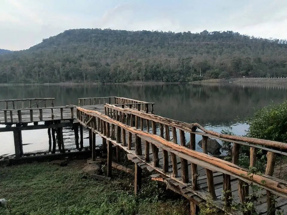
Huai Rai Reservoir in Mukdahan Province is a scenic water-resource and nature destination in Dong Mon Subdistrict, Mueang Mukdahan District. The reservoir lies within the valley landscape between Phu Kham Yang and Phu Mai Phai Ban, where forested slopes, open sky, and calm water create an atmosphere that feels very different from the busier riverside areas of Mukdahan city. Visitors come to enjoy the scenery, take photographs, relax beside the water, observe the natural environment, fish in permitted areas, and camp when prior approval has been obtained. Beyond tourism, the reservoir is an important part of the local water-management system, supporting agriculture, household water security, and the livelihoods of surrounding communities.
The location between two mountain systems gives Huai Rai Reservoir its distinctive enclosed landscape. The slopes of Phu Kham Yang and Phu Mai Phai Ban form a natural green frame around the water. On calm days, the reservoir reflects forests, clouds, and the outline of the hills. When wind moves through the valley, small waves spread across the surface and change the character of the view. Light, water level, cloud cover, and forest colour vary through the seasons, so travelers returning at different times of year encounter a noticeably different landscape.
The tourism name Huai Rai Reservoir is associated with the group of Huai Rai water-development projects in Dong Mon. In Royal Irrigation Department records, the principal medium-sized reservoir with an active monitoring station is identified as Huai Rai 2 Reservoir. It is managed by the Mukdahan Irrigation Project under Regional Irrigation Office 7 and forms part of a water-distribution system serving Dong Mon and nearby agricultural areas. Travelers may therefore encounter the names Huai Rai Reservoir, Huai Rai 2 Reservoir, and Huai Rai 2 Royal Initiative Reservoir on maps, signs, and official documents.
The Huai Rai 2 project originated from a royal initiative issued on 29 November 1999 to examine the construction of a reservoir and water-distribution system for residents of Dong Mon and surrounding areas. A further royal initiative on 18 November 2003 addressed the extension of the distribution system to agricultural land that had not yet received sufficient water. Development consequently included not only the dam and storage area but also pipelines, seasonal allocation, and the connection of stored water with farming communities.
The distribution system benefits 8 villages, approximately 100 households, and around 390 residents. The reported service area covers approximately 3,284 rai during the rainy season and 460 rai during the dry season. These figures show that the lake visible to travelers is not simply a scenic backdrop. It supports food production, farming income, household security, and the daily lives of local families. Visitors must therefore respect its operational role by keeping away from control structures, avoiding contamination, and never obstructing roads used by irrigation personnel.
Royal Irrigation Department station information records a normal storage capacity of approximately 2.68 million cubic metres and a maximum water-level capacity of about 3.10 million cubic metres. The catchment covers approximately 4.50 square kilometres. The dam is about 268 metres long and 15.50 metres high, while its spillway can discharge approximately 35 cubic metres per second. These engineering figures explain how the reservoir receives runoff from the surrounding hills, stores water during the rainy season, and releases it in accordance with irrigation and safety requirements.
The valley between Phu Kham Yang and Phu Mai Phai Ban provides natural conditions suitable for water storage. Rain falling on the slopes gathers in small channels and streams before reaching the lower basin. The reservoir slows and stores part of this runoff rather than allowing it to leave the area immediately. Forest cover above the lake is essential because trees, roots, and leaf litter reduce erosion and the movement of sediment. Loss of upstream forest would cause soil to enter the reservoir more quickly and gradually reduce its effective storage capacity.
The upstream landscape associated with the Huai Khaen, Huai Rai, and Huai Kha Na reservoirs has been restored through a royal-initiative watershed project. Activities have included moisture-retaining check dams, plant nurseries, and ecological forest planting. Species used in restoration have included rattan, bamboo, phak wan, mek, Siamese rosewood, redwood, pradu, makha mong, takhian, and yang na. The objective is to restore moisture, improve forest structure, protect water sources, and strengthen cooperation between communities and government agencies.
The forest surrounding the reservoir is therefore more than a visual feature. Tree canopies reduce the direct impact of rainfall, decomposing leaves retain moisture, and roots stabilise soil on the slopes. Small watercourses gradually carry runoff toward the reservoir. Forest habitat also supports birds, insects, reptiles, and small animals, giving the area educational value for visitors interested in ecology and watershed management.
Morning is one of the most peaceful times at Huai Rai Reservoir. Temperatures within the valley are often cooler than in open urban areas, wind is usually lighter, and the surface may remain almost still. Early sunlight appears through gaps in the surrounding hills and gradually changes the water from dark blue to pale gold. Photographers favour this period because the light is soft, the mountain shadows retain detail, and thin mist may form above the water when humidity and temperature are suitable.
Mist depends on moisture, overnight cooling, wind, and recent rainfall and cannot be guaranteed on any particular day. Travelers should not expect a dense sea of fog every morning. Even without mist, sunrise reveals the shape of the valley and creates attractive reflections. Anyone arriving before full daylight should carry a flashlight and select firm ground away from the water’s edge.
Midday offers the clearest view of the landscape. Forest colours, exposed shoreline, mountain ridges, and water-management structures become easier to distinguish. Open areas can become hot, especially between March and May, so visitors should bring drinking water, sun protection, and a hat. Resting areas should be chosen under safe shade without obstructing inspection routes used by irrigation staff.
Late afternoon is another rewarding period. Lower sunlight reflects across the reservoir and turns the surrounding hills into dark silhouettes. When thin cloud is present, orange, pink, and purple tones can continue after the sun disappears behind the ridge. Travelers should allow enough time to pack and leave before darkness because local approach roads may have limited lighting and small animals may move onto the road at night.
The rainy season, generally from May to October, brings more water into the reservoir and gives the surrounding forest its deepest green colour. The lake expands and the atmosphere becomes fresh and humid. It is also the period requiring the greatest caution. Water level can change, unpaved roads may become slippery, and areas used for sitting during the dry season may be submerged. Visitors should check the forecast, avoid thunderstorms, and remain well away from spillways and drainage structures.
The cool season from November to February is generally the most comfortable time to visit. Mornings and evenings are pleasant, skies are often clearer, and the humidity around the lake prevents the landscape from feeling excessively dry. This period is suitable for photography, quiet recreation, nature observation, and approved camping. Campers should still bring a light jacket because wind moving through the mountain gap can make the reservoir feel cooler than nearby villages.
During the dry season, falling water levels expose shoreline, rocks, tree stumps, and ground that was previously submerged. The scene looks very different from the rainy season but remains useful for understanding the annual water cycle. Vehicles should never be driven onto recently exposed ground because soft mud can trap them. Such areas may also be flooded again after upstream rain or operational changes in water release.
Fishing is a familiar activity around the reservoir, but it must comply with fisheries law, local rules, and any temporary restrictions. Destructive fishing equipment, electrical devices, obstructive nets, and fishing during prohibited periods are unacceptable. Fishing line, hooks, and packaging must be removed because discarded material injures birds, fish, and other visitors.
Swimming should not be treated as an unrestricted activity. A reservoir can have sudden changes in depth, soft sediment, underwater tree remains, and currents near outlets. Deep water may also be colder than expected and can cause muscle cramp. Visitors should not swim, jump from bridges or rocks, or use boats, rafts, kayaks, and flotation equipment without explicit permission from the responsible authority.
For practical planning, the visitor area can be understood as several functional zones. The first is the approach road and parking area. The second is the dam crest and broad-view zone. The third consists of relatively level shoreline recreation areas. The fourth includes permitted fishing points. The fifth is the camping area that requires advance coordination. The sixth consists of watershed forest and mountain access routes. The final zone includes water-control buildings, the spillway, and operational areas that are not open for unrestricted visitor access.
The dam crest provides a useful perspective on the relationship between the reservoir, surrounding hills, and downstream land. Visitors must walk and park only where permitted. Tents, vehicles, tables, and fishing equipment must not block the inspection route. Fences, gauges, gates, warning signs, and control equipment are part of the safety system and must never be touched or altered.
Level shoreline areas can be suitable for sitting, reading, and eating a prepared meal. A safe location should be well back from the water and free from erosion or unstable soil. Families must establish clear boundaries for children, who should never play alone beside the lake or on wooden structures. There is no assumption of permanent lifeguard coverage throughout the reservoir.
Camping has long been associated with the recreational image of Huai Rai Reservoir because the open setting provides direct access to sunrise scenery. Camping nevertheless requires advance coordination with Dong Mon Municipality, the Mukdahan Irrigation Project, or local caretakers. Campers must not choose the dam crest, spillway, inspection road, or a restricted operational area. Approval can change according to water level, maintenance, fire risk, and weather.
Campers need to be self-sufficient. The reservoir should not be expected to provide full commercial campground facilities such as electricity, showers, restaurants, tent rental, or permanent staff. Essential equipment includes a weather-resistant tent, sleeping bag, mat, flashlight, power bank, drinking water, food, personal medication, first-aid supplies, and bags for carrying all waste out. Open fires should not be used.
At night, lighting and noise should remain low. Loudspeakers, vehicle engines, and continuous spotlights disturb wildlife and other campers. Food must be sealed, and all scraps must be removed. Nothing should be buried or thrown into the reservoir because decomposing food and washing waste affect water quality.
The reservoir is suitable for landscape, reflection, sunrise, sunset, and community-life photography. A wide-angle lens captures the complete relationship between lake and mountains, while a medium focal length isolates forest detail and reflected light. Tripods should be placed on stable ground without blocking access and should never be positioned so close to the water that the photographer risks slipping.
Phone photographers should not walk backwards while looking at the screen. Vegetation can hide an abrupt drop at the shoreline. Wooden bridges or platforms should be inspected before use, and groups should not crowd weak structures. Drone operation requires permission and compliance with aviation regulations because the reservoir is state infrastructure surrounded by watershed forest.
Phu Pha Plong Fa Viewpoint offers an elevated view of Huai Rai 2 Reservoir and helps travelers understand the shape of the basin from above. At the shoreline, the experience is dominated by the scale of the water and surrounding slopes. From the viewpoint, visitors can see the reservoir, watershed, and community landscape as a connected system. Mountain access should be confirmed with local residents because route conditions change seasonally.
Phu Kham Yang is directly associated with the reservoir landscape. The area includes the Prathana Tham forest retreat and forest that has been used for biodiversity-related activities. The mountain is important as watershed, natural habitat, and a quiet religious environment. Visitors entering a monastic or meditation area should dress modestly, request permission, and keep noise to a minimum.
A wider nature itinerary can connect Huai Rai Reservoir with Wat Phra Phutthabat Phu Thong in Phon Ngam, Phu Pha San in Khamcha-i, and Khamcha-i Waterfall Park. Each provides a different experience: Phu Thong combines a Buddha footprint and hilltop sanctuary, Phu Pha San features a broad rock terrace and cave passage, and Khamcha-i Waterfall offers forest and stream scenery. Limiting a day trip to one or two additional places allows a safer and more meaningful visit.
Huai Rai Reservoir has strong potential as an outdoor learning site. Students can observe the water cycle, watershed forest, sediment control, irrigation, and the relationship between water storage and agriculture. A field visit can demonstrate why forest protects reservoir capacity and why stored water must be balanced between supply and dam safety. Educational groups should coordinate in advance and remain manageable in size.
Schools, universities, government agencies, and clubs planning camps or group events should provide participant numbers, vehicles, schedule, and activity type to the caretaker. Large competitions, amplified events, and mass gatherings are unsuitable without assessment of toilets, waste management, emergency access, and carrying capacity.
Safety depends on awareness of water level, ground conditions, and weather. Rain falling on the mountains can increase inflow even when the shoreline remains dry. Thunder, dark cloud, or a warning about water release should prompt visitors to move away from the lake immediately. Do not shelter under an isolated tall tree or remain on an exposed dam crest during lightning.
Shoreline ground includes rock, clay, sand, and woody debris. Smooth flip-flops and high heels are unsuitable. Closed footwear with reliable grip is recommended. Visitors arriving early or camping should wear long sleeves and carry insect repellent. Anyone with a history of severe insect allergy should bring the appropriate medication.
Older travelers can enjoy vehicle-accessible viewpoints and level areas according to current road conditions. They should avoid unstable slopes and slippery shoreline. Children must remain within immediate adult reach. Travelers with medical conditions should carry medication and emergency details. Mobile reception may be inconsistent between hills, so a trip plan should be shared with someone outside the group.
Cleanliness protects both tourism and water quality. Plastic bottles, foam boxes, fishing line, cans, cigarette ends, and food packaging must be taken away. Soap and detergent should never be used in the lake. Vehicles must not be washed at the shoreline, and oil or food waste must not enter the water. Small amounts of pollution become significant when repeated by many visitors.
Fire is a serious risk to the surrounding watershed forest, particularly late in the cool season and during the dry months. Open fires, rubbish burning, and discarded cigarettes are prohibited. Smoke or fire should be reported to Dong Mon Municipality, the Mukdahan Irrigation Project, or the Royal Irrigation Department hotline 1460. Visitors should not attempt wildfire suppression without training.
The reservoir is surrounded by working communities. Vehicles must not block farm tracks, house entrances, or routes used to transport produce. Photographs of residents and private homes require permission. Buying food, water, and local products within Dong Mon helps distribute tourism income and supports the community responsible for maintaining the destination.
Getting There from Mukdahan city requires traveling west toward Dong Mon Subdistrict and continuing on local roads toward the Ban Pa Rai and reservoir area. The driving distance is approximately 35–40 kilometres depending on the chosen route, normally requiring around 50–70 minutes. A private or rental vehicle is the most practical option because scheduled public transport does not reach the shoreline.
The Royal Irrigation Department reference coordinates for Huai Rai 2 Reservoir are 16.620647, 104.490966. Travelers should save an offline map and confirm the meeting point with Dong Mon Municipality because online maps may show Huai Rai Reservoir, Huai Rai 2, and nearby mountain viewpoints as separate markers. Fuel, tyre pressure, drinking water, and weather should be checked before leaving the main road.
Village roads are generally passable by normal vehicles, while final access to particular shoreline or camping points may include unpaved surfaces, potholes, mud, or erosion. A vehicle with reasonable ground clearance is more suitable during the rainy season. Drivers should never descend onto exposed reservoir ground or continue past a closure sign.
Travelers without a vehicle may hire a car with driver from Mukdahan city. Pickup time and location must be agreed before arrival because taxis do not wait at the reservoir and app-based transport cannot be relied upon in a remote area. A meeting point with mobile reception should be selected.
A half-day itinerary can begin with an early departure from Mukdahan city, arrival before the temperature rises, time for photography and quiet recreation, and a return during early afternoon. This option is suitable for families, older travelers, and visitors not planning to camp.
A full-day itinerary can combine the reservoir with Phu Pha Plong Fa or Phu Kham Yang in the morning, followed by a shoreline rest period, then Wat Phra Phutthabat Phu Thong or Phu Pha San. Mountain routes require a condition check and local coordination. Several separate mountain hikes should not be compressed into one day.
A two-day itinerary is appropriate for approved campers or travelers staying in Mukdahan city. Campers can watch evening light, remain in the authorised area, and photograph sunrise before cleaning the site. Hotel guests have easier access to bathrooms, food, and equipment preparation and can combine a reservoir day with the Mekong waterfront.
Restaurants with verified contact information are concentrated in Mukdahan city, approximately 38–45 kilometres from the reservoir. Travelers should eat or purchase supplies before entering Dong Mon. City restaurants offer Isan, Vietnamese, Thai, and riverside dining. Opening times should be reconfirmed, especially on public holidays.
Established accommodation is also concentrated in Mukdahan city. Staying there suits travelers arriving from another province or those who prefer standard hotel facilities rather than camping. Many hotels are close to restaurants, markets, and the Mekong waterfront, allowing a daytime reservoir visit followed by an evening in the city.
Facilities at the reservoir are basic rather than those of a major visitor centre. Travelers should bring water, food, medication, sun protection, and waste bags. Toilets, resting points, and wooden structures can change condition through age and weather and should be checked before use. Shops, electricity, and permanent staff should not be assumed.
There is no published general admission charge for basic visits. Guide services, local transport, organised programs, and camping may involve separate costs. Prices and service details should be agreed directly with recognised local providers.
The Mukdahan Irrigation Project under Regional Irrigation Office 7 is responsible for reservoir infrastructure and water management. Dong Mon Municipality supports local roads, tourism information, cleanliness, and community coordination. Travelers can contact the Mukdahan Irrigation Project at 042-611569 or Dong Mon Municipality at 042-661506 during office hours.
Abnormal water level, damaged structures, fallen trees, road failure, and accidents should be reported promptly. Useful information includes coordinates, time, photographs from a safe position, and the number of people involved. Irrigation emergencies and public enquiries can also be reported through hotline 1460.
The deepest value of Huai Rai Reservoir is the visible connection between water, forest, mountain, agriculture, and community. Without watershed forest, sediment would reduce storage. Without distribution systems, stored water would not reach farms. Without community cooperation, tourism areas would deteriorate. The destination demonstrates how natural landscape and public infrastructure can function together.
Responsible tourism consists of using recognised areas, carrying out waste, avoiding fire, staying out of the water, protecting vegetation, respecting wildlife, and keeping away from operational structures. Supporting community services further ensures that tourism contributes to the people who protect the reservoir.
Huai Rai Reservoir is therefore far more than a roadside photographic stop. It represents royal-initiative water development, watershed restoration, agricultural support, and a peaceful recreational landscape. Phu Kham Yang, Phu Mai Phai Ban, the reservoir, and Dong Mon communities combine to create a destination with environmental, social, and practical significance.
Travelers who prepare carefully, visit at an appropriate time, and respect local rules will discover a side of Mukdahan that contrasts with its better-known Mekong River identity. This is a landscape of mountain valleys, watershed forest, quiet water, and farming communities. Its simplicity is its defining attraction and the principal reason it deserves long-term protection.
| Name | Huai Rai Reservoir, Mukdahan Province |
| Irrigation Project Name | Huai Rai 2 Royal Initiative Reservoir |
| Location | Between Phu Kham Yang and Phu Mai Phai Ban, Dong Mon Subdistrict, Mueang Mukdahan District, Mukdahan Province |
| Access Address | Ban Pa Rai area, Dong Mon Subdistrict, Mueang Mukdahan District, Mukdahan 49000, Thailand |
| Reference Coordinates | 16.620647, 104.490966 |
| Highlights | Mountain-framed reservoir, Phu Kham Yang and Phu Mai Phai Ban scenery, sunrise, sunset, recreation, fishing, and approved camping |
| Key History | A royal initiative for reservoir and water-distribution development was issued on 29 November 1999, followed by an additional initiative concerning system extension on 18 November 2003. |
| Storage Capacity | Approximately 2.68 million cubic metres at normal storage level and 3.10 million cubic metres at maximum water level |
| Catchment Area | Approximately 4.50 square kilometres |
| Dam Dimensions | Approximately 268 metres long and 15.50 metres high |
| Benefited Area | Approximately 3,284 rai during the rainy season and 460 rai during the dry season, serving 8 villages |
| Distinctive Features | A medium-sized reservoir in a mountain-valley setting surrounded by watershed forest and quiet natural scenery |
| Main Areas / Zones | 1. Approach Road And Parking Area 2. Dam Crest And Panoramic View Zone 3. Shoreline Recreation Area 4. Permitted Fishing Points 5. Camping Area Requiring Prior Approval 6. Watershed Forest And Mountain Routes 7. Water-Control And Spillway Operational Zones |
| Activities | Sightseeing, photography, recreation, ecological learning, irrigation education, permitted fishing, and approved camping |
| Caretakers | Mukdahan Irrigation Project, Regional Irrigation Office 7, together with Dong Mon Municipality and local communities |
| Travel Information | Travel from Mukdahan city toward Dong Mon and continue to the Ban Pa Rai area. The driving distance is approximately 35–40 km and normally takes 50–70 minutes. |
| Current Status | Open as a Dong Mon tourism destination and actively managed within the Mukdahan irrigation system |
| Open Days | Daily |
| Opening Hours | 08.00 – 17.00 |
| Fees | No general admission fee; guide, local transport, organised activities, and camping may involve separate charges |
| Facilities | Basic parking and resting areas; visitors should bring water, food, medication, lighting, and waste bags |
| Camping | Advance approval is required. Camping on the dam crest, spillway, inspection road, or operational area is prohibited. |
| Visitor Guidelines | Do not swim, use boats without permission, light fires, leave waste, interfere with irrigation structures, or ignore warning signs. |
| Main Contact Numbers | Mukdahan Irrigation Project: 042-611569 Dong Mon Municipality: 042-661506 Royal Irrigation Department Hotline: 1460 |
| Official Information | Dong Mon Municipality And Mukdahan Irrigation Project |
| Nearby Tourist Attractions | 1. Phu Pha Plong Fa Viewpoint, approximately 7 km 2. Prathana Tham Forest Retreat At Phu Kham Yang, approximately 9 km 3. Wat Phra Phutthabat Phu Thong, approximately 18 km 4. Phu Pha San, Khamcha-i District, approximately 24 km 5. Khamcha-i Waterfall Park, approximately 33 km |
| Nearby Restaurants | 1. Krua Saigon Mukdahan, approximately 38 km, Tel. 042-632303 2. Zaeb Rim Khong, approximately 40 km, Tel. 097-051-7988 3. Baan Lao Yuan Na Rim Khong, approximately 41 km, Tel. 042-611111, 065-142-3915 4. Sawan Sumran, approximately 42 km, Tel. 042-632669 5. Narin Restaurant, approximately 42 km |
| Nearby Accommodations | 1. HOP INN Mukdahan, approximately 38 km, Tel. 092-258-7318 2. Hotel MUQ, approximately 39 km, Tel. 063-787-5555, 042-040-888 3. Ploy Palace Hotel, approximately 40 km, Tel. 042-614988 4. Hotel de Ladda, approximately 42 km, Tel. 042-611499 5. Riverfront Hotel Mukdahan, approximately 43 km, Tel. 042-612948-9, 081-703-1705 |
Frequently Asked Questions (FAQ)
Q: Where is Huai Rai Reservoir located?
A: Huai Rai Reservoir is located between Phu Kham Yang and Phu Mai Phai Ban in Dong Mon Subdistrict, Mueang Mukdahan District. The reference coordinates for Huai Rai 2 Reservoir are 16.620647, 104.490966.
Q: What are the opening hours and is there an admission fee?
A: The reservoir is open daily from 08.00 to 17.00. There is no general admission fee, while guide, transport, organised activity, and camping services may involve separate charges.
Q: Can visitors camp at Huai Rai Reservoir?
A: Camping is possible only after advance coordination and approval. Tents must be placed in a designated area and are prohibited on the dam crest, spillway, inspection road, and operational zones.
Q: Can visitors swim or use a boat?
A: Swimming and unauthorised boating are not recommended because water depth is uneven and the reservoir contains submerged hazards and water-control structures. Water activities require permission.
Q: When is the best time to visit?
A: November to February provides the most comfortable weather. The rainy season offers greener forest and more water but requires close attention to storms, road conditions, and changing water levels.
Q: Why is Huai Rai Reservoir important to local communities?
A: The reservoir supports 8 villages and serves approximately 3,284 rai during the rainy season and 460 rai during the dry season.
Q: What should travelers bring?
A: Bring drinking water, food, sun protection, closed footwear, personal medication, a flashlight, a power bank, an offline map, and bags for carrying all waste out.
Q: Who should visitors contact for current information?
A: Contact the Mukdahan Irrigation Project at 042-611569, Dong Mon Municipality at 042-661506, or the Royal Irrigation Department hotline at 1460.
 Category: ●Nature and Wildlife
 Group: ●Dam, Reservoir, Lake
Last Update : 3 MonthAgo
 Last Update : 3 MonthAgo
 Click to Access the Navigation Map GPS
 Art, Culture and Heritage
 Historical Sites and Monuments(2)
 Landmarks and Memorials(3)
 Art, Craft Centres, Tradition(2)
 Museums(1)
 Places of Worship
 Temple(17)
 Other Sacred Sites(3)
 Suburban Living
 Village, Community(4)
 Local Market(2)
 National Parks and Marine Reserves(4)
 Mountain (Doi)(5)
Dam, Reservoir, Lake(3)
Mountain (Doi)(5)
Dam, Reservoir, Lake(3)
 Waterfalls(5)
 Caves(2)
 River, Canal(2)
 Bays and Beaches(1)
 Other natural attractions(1)
 Entertainment and Agricultural
 Farms, Parks and Ecotourism(1)


