
lovethailand home >Northeastern Travel Attractions >Mukdahan Travel Attractions >Nikhom Kham Soi >Nikhom Kham Soi > Huai Khi Lek Irrigation Reservoir
TL;DR: Huai Khi Lek Irrigation Reservoir is located at Ban Dan Yao, Moo 8, Na Kok Subdistrict, Nikhom Kham Soi District, Mukdahan Province, Thailand, open Daily, hours 06.00 – 18.30.

Huai Khi Lek Irrigation Reservoir
Open Days: Daily
Opening Hours: 06.00 – 18.30
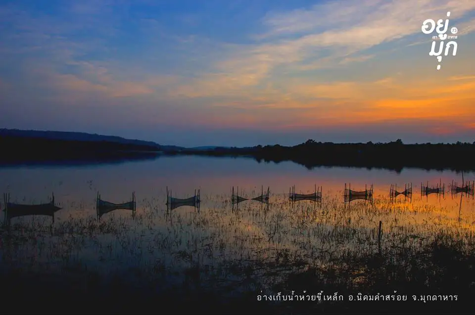
Huai Khi Lek Irrigation Reservoir is a medium-sized working reservoir and one of the notable natural attractions in Nikhom Kham Soi District, Mukdahan Province. It lies beside Highway 212 on the Mukdahan–Loeng Nok Tha route at Ban Dan Yao in Na Kok Subdistrict, approximately 2 kilometres from central Nikhom Kham Soi and about 23 kilometres from Mukdahan city. Its main attraction is the broad expanse of water, which resembles a large inland lake surrounded by low mountains, farmland and the open countryside of northeastern Thailand. The reservoir is suitable for sightseeing, photography, sunrise and sunset viewing, relaxed family outings and learning how irrigation, farming, freshwater ecology and local communities are connected.
The reservoir is more than a recreational destination. It is an important piece of water infrastructure that stores water for agriculture, household use, dry-season resilience and the management of seasonal rainfall. Its normal storage capacity is approximately 26.75 million cubic metres, while its high-water capacity is around 30 million cubic metres. Huai Khi Lek Reservoir therefore supports local livelihoods while also creating a large and attractive waterscape that improves the environmental and recreational value of the surrounding area.
For travelers using the Mukdahan–Loeng Nok Tha road, the reservoir is an accessible place to stop without needing to hike or use a four-wheel-drive vehicle. The main approach follows a paved highway, and visitors can arrive by private car, rental car, motorcycle or local transport serving Nikhom Kham Soi District. The reservoir is situated before the turn toward Phu Mu Forest Park, allowing both places to be included in the same nature-focused itinerary. It is particularly convenient for a half-day or full-day excursion from Mukdahan city.
The upper section of the reservoir opens into a wide body of water extending through the natural drainage basin. During periods of high water, the landscape resembles a substantial lake. Toward the end of the dry season, more shoreline, exposed ground and the natural contours of the catchment may become visible. These seasonal changes mean that the scenery does not remain identical throughout the year. Repeat visitors may encounter a full blue reservoir, lush post-rain vegetation or a more open dry-season landscape revealing the underlying shape of the basin.
The surrounding terrain forms a transition between agricultural plains and the mountainous landscapes of Mukdahan Province. Forest, farmland and local settlements contrast with the blue or green surface of the water. On clear days, clouds and the sky are reflected across the reservoir. Early mornings may bring soft light over the hills and a thin layer of moisture above the water, while late afternoon sunlight turns the surface gold. These conditions make the reservoir especially appealing for landscape photography and quiet evening relaxation.
Huai Khi Lek Reservoir was developed to strengthen water management for Nikhom Kham Soi District and nearby communities. Over time, local people also began using the area for rest, fishing and small-scale tourism. The reservoir now represents several interconnected uses: supplying water to farmland, reducing the effects of water shortages, supporting freshwater fisheries and creating income opportunities for local restaurants, raft operators and other community businesses.
From an irrigation engineering perspective, the reservoir has a catchment area of approximately 80.60 square kilometres. Its dam or embankment is about 800 metres long and approximately 16 metres high. Water management must account for rainfall, inflow, agricultural demand and the structural safety of the irrigation system. Conditions are monitored by the Mukdahan Irrigation Project under Regional Irrigation Office 7 of the Royal Irrigation Department. Visitors should therefore remember that this remains active public infrastructure rather than a purpose-built recreational park.
The reservoir is particularly important to agriculture during the dry season. Stored water supports cultivation and other household economic activities under the allocation system managed by the irrigation authorities. It also helps moderate seasonal fluctuations by retaining part of the inflow received during the rainy season. This combination of functions gives the reservoir economic, social, ecological and water-security value far beyond its appearance as a scenic lake.
The freshwater ecosystem supports fish, prawns, shellfish, crabs and smaller aquatic organisms that form part of the local food chain. Shallow shoreline areas also provide feeding habitat for birds and other wildlife associated with freshwater environments. This ecological productivity supports traditional fishing and local food resources. Fishing activities, however, should comply with local rules, seasonal restrictions and conservation measures so that fish populations and habitats remain viable in the long term.
The atmosphere differs considerably from that of central Mukdahan. There is no dense concentration of commercial buildings, constant urban traffic or highly structured tourism program. The appeal comes from the open water, the wind moving across the reservoir and glimpses of everyday rural life. It is a suitable place for travelers who want to rest their eyes, spend time with family, enjoy a simple meal or pause during a road journey along Highway 212.
The most comfortable visiting periods are approximately 06.00–09.00 and 16.00–18.30. Temperatures are generally lower, sunlight is less intense and the angle of the light is more suitable for photography. Midday visits are possible, but shade is not evenly distributed around the open shoreline. During the hot season, visitors should carry drinking water, a hat, an umbrella and sun protection. Those planning to watch the sunset should arrive 30–45 minutes early to choose a safe viewing position and avoid returning after the area becomes dark.
The rainy season, broadly from May to October, brings greener vegetation and greater inflow into the reservoir. Skies after rainfall can be visually dramatic, but visitors should check the forecast because heavy rain, strong wind and slippery ground may affect safety. The cool season from November to February is generally the most comfortable period for sightseeing. The hot season from March to April often provides clear skies and strong visibility, although prolonged exposure to the midday sun should be avoided.
The most popular activity is simply enjoying the view across the water and surrounding hills. Visitors can park in permitted locations that do not obstruct traffic and rest at a safe distance from the shoreline. Local families sometimes bring mats, food and drinks, while photographers concentrate on wide landscapes, reflections, fishing activity or the changing colors of sunset. A wide-angle lens is useful for the overall environment, while a telephoto lens can isolate boats, distant hills and activity across the water.
Walking or cycling on roads and paths that remain open to the public provides another way to experience the reservoir. Cyclists must remain aware of vehicles using the same routes and should not enter operational areas near control buildings, outlet gates, spillways or canals. Brakes, tires and lights should be checked before riding, as some surfaces may contain gravel, uneven sections or mud after rain. Early morning cycling is generally cooler and provides better visibility than riding after sunset.
Several private businesses operate food and raft services beside the reservoir. Available experiences may include dining on a floating platform, relaxing over the water, short raft trips within designated areas or small-group activities. Operations can change according to water level, weather, customer demand and safety requirements. Travelers planning to use these services should contact the operator directly to confirm opening times, prices, passenger limits, life jackets and conditions concerning outside food and drinks.
Families with children can use the visit as an opportunity to introduce young travelers to freshwater ecology and irrigation management. Constant adult supervision is essential because some shoreline sections are steep, unfenced or affected by changing water levels. Children should not run beside the water, swim in undesignated areas or climb irrigation structures. A level resting place set well back from the shoreline is the safest choice for a family picnic.
Older travelers can reach the main area by vehicle without completing a long walk. Nevertheless, facilities are less comprehensive than at a large visitor center. Families traveling with elderly members should bring drinking water, regular medication, a folding chair and any required mobility aid. Restrooms and dining facilities are generally associated with operating restaurants or private service areas, so these services should be confirmed before arrival when they are essential to the visit.
The main areas around the reservoir include the dam crest or embankment, from which the general structure and water can be viewed; the upper lake-like section of the reservoir; shoreline areas used for local recreation; privately operated raft and restaurant areas; and operational irrigation zones containing outlets, canals and water-control structures. These areas serve different purposes. Visitors must follow signs, staff instructions and the access conditions established by each operator.
There is no single compulsory viewpoint because the shape of the reservoir and surrounding roads provides several perspectives. The best position changes with water level, sunlight and ground conditions. Sunset photographers should check the direction of the light and avoid placing tripods on roads or other places where vehicles need to pass. Drone use must comply with Thai aviation law, local rules and restrictions concerning important infrastructure. Flights must not interfere with officials, residents, wildlife or other visitors.
Weekdays usually offer a quieter atmosphere suitable for reading, photography and unhurried relaxation. Weekends and periods of pleasant weather may attract more local families, diners and raft customers. Early mornings are preferable for visitors seeking silence. Groups intending to dine or use a raft should call ahead, particularly on holidays, to confirm that the service is operating and that sufficient seating is available.
Although the large body of water may look suitable for swimming, visitors should not enter the water in areas that have not been specifically designated for that activity. Depth can change abruptly, the underwater ground may be uneven and hidden hazards may include submerged vegetation, fishing equipment or currents near outlets. Anyone using a boat or raft should wear a life jacket, check the condition of the equipment and follow the operator’s instructions. Water activities should be avoided during thunderstorms, strong winds or poor visibility.
Anglers should confirm permitted fishing areas and applicable local rules before starting. Destructive equipment must not be used, and fishing line, hooks, pieces of net and bait containers must never be left beside or inside the reservoir. These materials can injure birds, aquatic animals and other visitors. Releasing undersized fish and respecting breeding periods help preserve the fishery for the local community.
Keeping the reservoir clean is an important part of responsible travel. All plastic bags, foam boxes, glass bottles, cans and food waste should be removed from the site. Cooking oil and food liquids must not be poured into the water. Open fires should not be lit on dry grass or close to vegetation because they can spread rapidly. Reusable containers and reduced single-use packaging help protect both the scenery and the freshwater ecosystem.
One of the most meaningful aspects of a visit is observing the relationship between the reservoir and surrounding communities. Travelers may see small fishing boats, fishing equipment, cultivated land and the movement of agricultural produce along rural roads. These scenes demonstrate that the reservoir is not merely a scenic background. It is connected to food, income and household security. Visitors should avoid entering private land, interfering with local work or photographing people at close range without permission.
Nature observers can look for shoreline plants, waterbirds, insects and signs of changing water levels. Early morning is usually more suitable for birdwatching than busy afternoon periods. Binoculars allow wildlife to be observed from a respectful distance. Visitors should not approach nesting areas, play loud sounds, capture animals or leave food to attract wildlife, as these actions can alter natural behavior and cause long-term disturbance.
From Mukdahan city, follow Highway 212 toward Nikhom Kham Soi and Loeng Nok Tha. The road distance is approximately 23 kilometres. On reaching Nikhom Kham Soi District, follow directions toward Ban Dan Yao in Na Kok Subdistrict. The reservoir is about 2 kilometres from the district center and lies before the route leading to Phu Mu Forest Park. Driving normally takes approximately 25–35 minutes, depending on the starting point and traffic conditions.
Travelers approaching from Loeng Nok Tha can use Highway 212 toward Mukdahan. Near Nikhom Kham Soi, follow road signs or search for Huai Khi Lek Reservoir in a navigation application. As the name Huai Khi Lek is used in several parts of Thailand, entering the coordinates 16.2534821, 104.5719682 helps identify the reservoir in Mukdahan Province accurately.
Public transport users can take a bus or local vehicle serving the Mukdahan–Nikhom Kham Soi or Mukdahan–Loeng Nok Tha route and disembark in central Nikhom Kham Soi. A local taxi or hired vehicle is then required for the final section to the reservoir. Public vehicles may not enter every viewpoint or operate late in the evening. Travelers should agree on the fare, return time and pickup point before the driver leaves. Renting a car in Mukdahan can be more practical for those also visiting Phu Mu Forest Park and other rural attractions.
Getting There by private car is the most flexible option because it allows travelers to stop at several viewpoints, use local restaurants and continue to nearby attractions according to their own schedule. Carry sufficient fuel, check tire pressure and brakes, and take additional care when continuing into hilly areas. Vehicles should not be parked on bends, in staff access points or in restricted sections of the dam. Children, pets and valuable property should never be left inside a vehicle in direct sunlight.
A half-day itinerary can begin with an early departure from Mukdahan city, followed by morning scenery at the reservoir and breakfast or lunch in Nikhom Kham Soi. Travelers can then continue to Phu Mu Forest Park before returning to the city in the afternoon. A full-day itinerary may add the Rom Klao wind farm and finish at Wat Roi Phra Phutthabat Phu Manorom, Ho Kaeo Mukdahan or the Indochina Market beside the Mekong River. Sufficient travel time should be allowed, and the opening hours of each destination should be checked before departure.
Nature-focused visitors can spend the morning beside the reservoir and continue to Phu Mu Forest Park, where the landscape changes to mountain forest and dry dipterocarp vegetation. Combining these places in one day demonstrates the ecological diversity of Mukdahan, from freshwater habitat and farmland to upland forest. Suitable walking shoes, drinking water and rain protection should be carried.
Photography enthusiasts may prefer an itinerary that begins with morning light at the reservoir, continues through Nikhom Kham Soi and reaches the Rom Klao wind farm during the afternoon. The day can end with sunset at the reservoir or dinner in Mukdahan city. The visual contrast between wind turbines on elevated land and the broad inland water creates a varied photographic journey within one day.
Useful items include drinking water, a hat, an umbrella, sunscreen, insect repellent, a bag for personal rubbish, a camera and a portable power bank. During the rainy season, carry a raincoat or strong umbrella and wear shoes with good traction. A mat or folding chair can be useful for a longer stay, but equipment must not obstruct roads or be placed close to the water’s edge.
Mobile phone service is generally available, although signal strength may vary between networks and locations around the reservoir. Saving an offline map and essential telephone numbers before departure is advisable. Solo travelers should share their itinerary with someone they trust, avoid isolated areas after sunset and carry a small flashlight for emergencies.
Pets may accompany their owners in open areas where no specific restriction applies, but they should remain on a lead and must not disturb other visitors, birds or wildlife. Owners are responsible for removing animal waste. Permission should be obtained before taking a pet onto a raft or into a restaurant because individual operators have different policies.
Ordinary travel photography is appropriate in public areas that are open to visitors. Photographers should avoid interfering with water-control operations or taking intrusive images of security arrangements and staff activity. Commercial filming, large crews and extensive equipment may require advance permission from the Mukdahan Irrigation Project.
There is no admission fee for general sightseeing and relaxation. Food, raft trips, boats and privately operated activities are charged separately. Prices may depend on the service, duration, group size and season. Visitors should confirm the cost and conditions directly with an identifiable operator before paying.
Facilities are distributed among the areas currently in use and the businesses operating beside the reservoir. Depending on the day, visitors may find parking areas, simple seating, restaurants, restrooms and private raft services. This is not a large visitor complex where every facility operates continuously. Travelers should therefore carry essential personal supplies, particularly when arriving early, visiting on a weekday or traveling during unfavorable weather.
The principal authority responsible for the reservoir is the Mukdahan Irrigation Project under Regional Irrigation Office 7 of the Royal Irrigation Department. The operational area is managed through Water Delivery and Maintenance Division 1. Responsibilities include controlling water levels, maintaining structures, allocating water and protecting the irrigation system. Damage, unsafe conditions or emergencies involving the infrastructure should be reported to officials rather than handled by visitors.
Huai Khi Lek Reservoir is therefore more than a roadside viewpoint. It brings together irrigation, freshwater ecology, farming, fishing, community life and local tourism. A visitor may stop briefly to rest and view the water or spend several hours photographing the landscape, dining and learning about the surrounding environment. Respecting access rules, avoiding unsafe swimming and removing all rubbish will help preserve both the beauty and practical value of this important Mukdahan water resource.
| Name | Huai Khi Lek Irrigation Reservoir |
| Thai Name | อ่างเก็บน้ำชลประทานห้วยขี้เหล็ก |
| Location | Ban Dan Yao, Moo 8, Na Kok Subdistrict, Nikhom Kham Soi District, Mukdahan Province, Thailand |
| Main Route | Highway 212 on the Mukdahan–Loeng Nok Tha route, before the turn toward Phu Mu Forest Park |
| Coordinates | 16.2534821, 104.5719682 |
| Highlights | A broad lake-like reservoir, mountain scenery, sunrise and sunset views and a peaceful rural atmosphere close to Nikhom Kham Soi |
| Attraction Type | Working irrigation reservoir, natural attraction, scenic viewpoint and local recreation area |
| Importance | Stores water for agriculture and household use while supporting water management, freshwater ecology, fishing and community businesses |
| Normal Storage Capacity | Approximately 26.75 million cubic metres |
| High-Water Capacity | Approximately 30 million cubic metres |
| Catchment Area | Approximately 80.60 square kilometres |
| Structure | Dam or embankment approximately 800 metres long and 16 metres high |
| Freshwater Ecology | Habitat for fish, prawns, shellfish, crabs and other freshwater organisms, with shoreline feeding areas for birds |
| Activities | Sightseeing, photography, sunrise and sunset viewing, relaxation, dining, birdwatching, cycling on open routes and private raft services |
| Main Areas / Zones | 1. Dam crest and structural viewpoint 2. Upper reservoir and lake-like water area 3. Shoreline recreation areas 4. Privately operated raft and restaurant areas 5. Outlet structures, irrigation canals and operational zones |
| Facilities | Parking in designated areas, simple resting places, restaurants, restrooms and private raft services when operating |
| Open Days | Daily |
| Opening Hours | 06.00 – 18.30 |
| Fees | No general admission fee; food, rafts, boats and private activities are charged separately |
| Best Visiting Period | 06.00–09.00 and 16.00–18.30; the cool season and the period following rainfall provide comfortable conditions and attractive scenery |
| Safety | Do not swim in undesignated areas, stay away from outlets, spillways and operational zones, supervise children and wear a life jacket on boats or rafts |
| Travel Information | Follow Highway 212 from Mukdahan city toward Nikhom Kham Soi. The reservoir is approximately 23 km from the city and 2 km from central Nikhom Kham Soi |
| Current Status | An active irrigation reservoir open for public sightseeing and recreation in permitted areas |
| Caretaker | Water Delivery and Maintenance Division 1, Mukdahan Irrigation Project, Regional Irrigation Office 7, Royal Irrigation Department |
| Main Contact Number | Mukdahan Irrigation Project: +66 42 611 569 |
| Nearby Tourist Attractions | 1. Phu Mu Forest Park, approximately 18 km, Tel. +66 42 619 076 2. Rom Klao Wind Farm, approximately 22 km, Tel. +66 99 532 7027 3. Ho Kaeo Mukdahan, approximately 25 km 4. Mukdahan Indochina Market, approximately 27 km 5. Wat Roi Phra Phutthabat Phu Manorom, approximately 31 km |
| Nearby Restaurants | 1. Lake View Raft Restaurant at Huai Khi Lek Reservoir, approximately 1 km, Tel. +66 84 962 3394 2. Songpeenong Kitchen, approximately 4 km, Tel. +66 61 009 7147, +66 88 549 5231 3. 209 Kaprao Buem, approximately 5 km, Tel. +66 99 443 7563 4. Art Garden Steak House, approximately 5 km 5. Saen Kham Restaurant, Ban Kham Saen Suk, approximately 6 km |
| Nearby Accommodations | 1. KD Resort Nikhom Kham Soi, approximately 4 km, Tel. +66 81 262 6638 2. Zigzag Resort Mukdahan, approximately 20 km 3. HOP INN Mukdahan, approximately 24 km, Tel. +66 92 258 7318 4. Riverfront Hotel Mukdahan, approximately 27 km, Tel. +66 42 612 948–9, +66 81 703 1705 5. Hotel de Ladda, approximately 28 km, Tel. +66 42 611 499, +66 42 611 497 |
Frequently Asked Questions (FAQ)
Q: Where is Huai Khi Lek Irrigation Reservoir?
A: It is located at Ban Dan Yao, Moo 8, Na Kok Subdistrict, Nikhom Kham Soi District, Mukdahan Province, beside Highway 212. It is approximately 23 kilometres from Mukdahan city.
Q: What are the opening hours of Huai Khi Lek Reservoir?
A: The reservoir is open daily from 06.00 to 18.30. Early morning and late afternoon provide the most comfortable weather and the best light for photography.
Q: Is there an admission fee?
A: There is no general admission fee. Food, raft trips, boats and privately operated activities are charged separately.
Q: What can visitors do at the reservoir?
A: Visitors can enjoy the scenery, take photographs, watch sunrise or sunset, relax, dine, observe birds, cycle on open routes and use private raft services when available.
Q: Is swimming permitted at Huai Khi Lek Reservoir?
A: Visitors should not swim in areas that have not been specifically designated for swimming because of changing depth, uneven underwater ground and potential hazards near irrigation structures.
Q: How can travelers reach the reservoir from Mukdahan city?
A: Follow Highway 212 toward Nikhom Kham Soi and Loeng Nok Tha for approximately 23 kilometres. The reservoir is around 2 kilometres from central Nikhom Kham Soi.
Q: When is the best time to visit?
A: November to February provides the most comfortable weather. The landscape is also particularly green after rainfall. The recommended times of day are 06.00–09.00 and 16.00–18.30.
Q: Which attractions can be combined with the reservoir?
A: A day trip can include Phu Mu Forest Park, the Rom Klao wind farm, Ho Kaeo Mukdahan, Mukdahan Indochina Market and Wat Roi Phra Phutthabat Phu Manorom.
 Category: ●Nature and Wildlife
 Group: ●Dam, Reservoir, Lake
Last Update : 3 MonthAgo
 Last Update : 3 MonthAgo
 Click to Access the Navigation Map GPS
Huai Khi Lek Irrigation Reservoir Map
Recommend

 Art, Culture and Heritage
 Historical Sites and Monuments(2)
 Landmarks and Memorials(3)
 Art, Craft Centres, Tradition(2)
 Museums(1)
 Places of Worship
 Temple(17)
 Other Sacred Sites(4)
 Suburban Living
 Village, Community(4)
 Local Market(2)
 National Parks and Marine Reserves(4)
 Mountain (Doi)(5)
Dam, Reservoir, Lake(3)
Mountain (Doi)(5)
Dam, Reservoir, Lake(3)
 Waterfalls(5)
 Caves(2)
 River, Canal(2)
 Bays and Beaches(1)
 Other natural attractions(1)
 Entertainment and Agricultural
 Farms, Parks and Ecotourism(1)
 Travel Articles, Recipes
 Travel Review, Food Review(1)


