
lovethailand home >North Travel Attractions >Chiang Mai Travel Attractions >Doi Tao >Ban Aen > Wat Ban Aen
TL;DR: Wat Ban Aen is located at Moo 2, Ban Aen, Ban Aen Subdistrict, Doi Tao District, Chiang Mai Province 50260, Thailand.

Wat Ban Aen
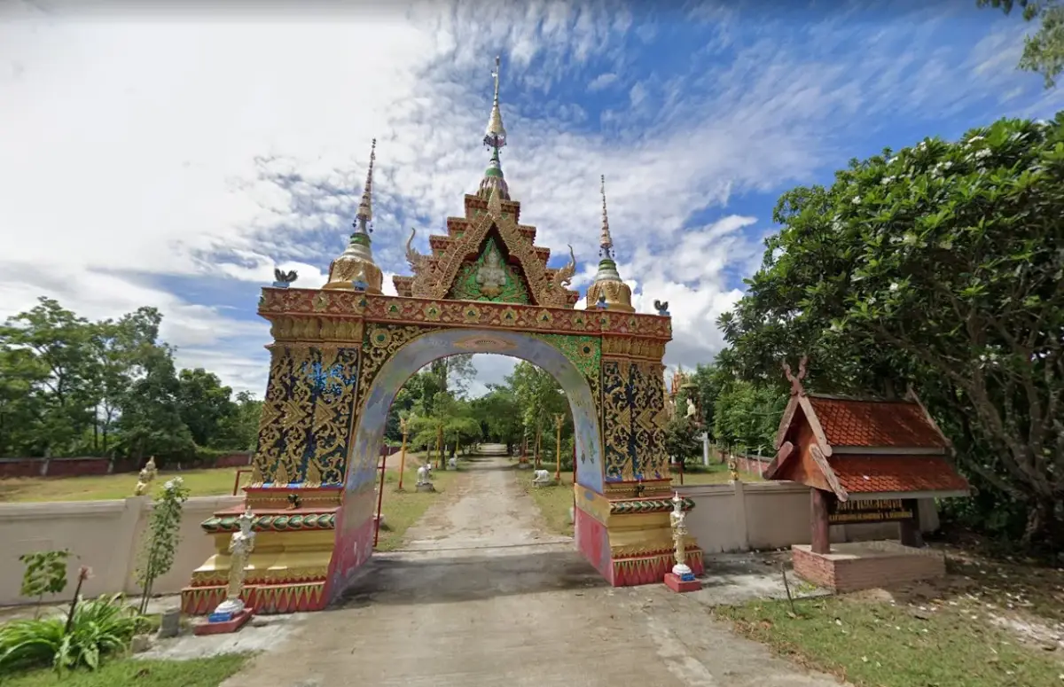
Operating day: Daily
Operating time: 08.00 - 17.00
Wat Ban Aen is located in Moo 2, Ban Aen, Ban Aen Subdistrict, Doi Tao District, Chiang Mai Province 50260. It is a local Buddhist temple under the Maha Nikaya order. The temple was officially permitted as a temple in 1817 and received its royal grant of Wisungkhamasima in 1991. According to the temple history used for this article, the abbot is Phra Thit Thanakaro. Wat Ban Aen is one of the oldest and most meaningful community temples in Doi Tao, deeply connected with the Ban Aen community, the Ping River basin, the changes caused by Bhumibol Dam, and the rebuilding of local life in the present settlement area.
The importance of Wat Ban Aen comes from its long history. Since its establishment in 1817, the temple has been part of the spiritual life of the community for more than 200 years. A temple with this kind of continuity is not only a place for worship. It becomes part of the village identity, a place for merit-making, Buddhist teaching, ordination, annual ceremonies, and the connection between monks, elders, families, youth, and local residents.
Ban Aen is an important area in the history of Doi Tao. In earlier times, Doi Tao was under the administration of Hot District and included several important subdistricts such as Ban Aen, Mued Ka, Tha Duea, and Doi Tao. Ban Aen therefore belonged to the old settlement structure of the district, with deep links to the Ping River, local travel routes, and community life before Doi Tao became a separate district. Wat Ban Aen should therefore be understood together with the broader history of Ban Aen, not only as an isolated temple.
Before the landscape changed after the construction of Bhumibol Dam, Ban Aen communities lived closely with the Ping River. The river supported agriculture, fishing, transport, and contact with nearby settlements. In this riverside way of life, the temple was part of the daily landscape. It was where villagers gathered for Buddhist practice, seasonal merit-making, and community ceremonies. Wat Ban Aen therefore carries the memory of the old river-based life of Ban Aen.
A major turning point came after Bhumibol Dam was completed in 1964. The water level in the Ping River rose and formed a large reservoir, flooding farmland and old riverside areas in Ban Aen, Mued Ka, and Tha Duea. Many villagers had to relocate from their original homes. Some families moved to allocated settlement areas, while others rebuilt their lives elsewhere. In this period of change, temples became spiritual anchors that helped communities preserve memory, faith, and continuity.
Many Ban Aen residents resettled in the present area after the river landscape changed. Local memories describe the early period as difficult because the new land was higher and less convenient for water use than the former riverside settlements. In this context, Wat Ban Aen became more than a place of worship. It helped support the emotional and cultural continuity of villagers moving from the old river community to the new settlement area.
The name Wat Ban Aen clearly expresses the connection between the temple and the community. It shares the name of the village and subdistrict, making the temple a cultural marker of Ban Aen. To visit Wat Ban Aen is therefore to encounter the history of an old riverside community, the impact of dam-related change, and the continuing faith of local people in Doi Tao.
The royal grant of Wisungkhamasima in 1991 is an important milestone in the temple’s religious history. A Wisungkhamasima boundary is used for formal monastic acts under Buddhist discipline and indicates a stable religious role. For a long-established community temple such as Wat Ban Aen, this grant reinforces its place as an important Buddhist institution for the local community.
Phra Thit Thanakaro is listed as the abbot of Wat Ban Aen in the temple history used for this article. In a community temple, the abbot plays a central role in guiding Buddhist activities, maintaining the temple, supporting merit-making, and connecting monks with villagers. The temple’s continuing role depends not only on its age but also on the care of monks and the faith of local residents.
Ban Aen Subdistrict covers about 32 square kilometers, or approximately 15,250 rai. The landscape is mainly flat, with the Ping River on the western side, and roads reaching all villages. The subdistrict is about 13 kilometers north of Doi Tao District Office and about 19 kilometers from Hot District. This location makes Ban Aen a useful cultural stop between Hot and Doi Tao, especially for travelers interested in village temples and local history.
Ban Aen Subdistrict includes several communities, such as Ban Wang Mo, Ban Aen Mai, Ban Aen Chadsan, and Ban Huai Sai Mun. These communities are connected with the older Ban Aen landscape and the settlement patterns that followed the flooding of the Ping River basin. Wat Ban Aen stands within this network of villages and continues to serve as a shared space of faith, culture, and community memory.
The local economy is based mainly on agriculture, trade, and general labor, with a large agricultural area in the subdistrict. Wat Ban Aen stands in a community where daily life is still connected with land, cultivation, seasonal rhythms, and Buddhist merit-making. On Buddhist holy days, during Buddhist Lent, at the end of Lent, Kathin, and robe-offering ceremonies, the temple remains an important place where villagers gather.
The main appeal of Wat Ban Aen is not large-scale tourism or monumental architecture. Its value lies in its long history, its connection with the old Ban Aen community, and its role as a living village temple. It is suitable for travelers who want to understand Doi Tao beyond lake scenery, especially those interested in community temples, relocation history, and local Lanna Buddhist life.
Specific public details about individual structures at Wat Ban Aen, such as the viharn, ubosot, chedi, principal Buddha image, bell tower, or sermon hall, are not sufficiently fixed for detailed architectural description. The temple should therefore be appreciated primarily for its verified status, long history, community role, and relationship with Ban Aen’s riverside memory and present settlement life.
Religious traditions at Wat Ban Aen follow the rhythm of a northern Thai local temple: Buddhist holy days, Makha Bucha, Visakha Bucha, Asalha Bucha, Buddhist Lent, the end of Lent, Kathin, robe-offering ceremonies, and memorial merit-making. These events are not only religious ceremonies. They keep villagers connected and help pass Buddhist values from one generation to the next.
Wat Ban Aen can be combined with nearby cultural and natural stops in Ban Aen and Doi Tao, such as Wat Phingkaram, Wat Si Phing Chai, Wat Mokkha Wanaram, the Doi Tao Lake grassland area, Wat Ban Noi in Bong Tan Subdistrict, and Doi Tao Lake. This route gives visitors a wider view of Ban Aen through religion, community history, relocation memory, and the landscape of the reservoir.
Getting There is easiest by private car, rental car, or local hired transport. From Chiang Mai city, travel south on Highway 108 through Hang Dong, San Pa Tong, Chom Thong, and Hot District. From Hot, continue toward Doi Tao and Ban Aen Subdistrict. Once in Moo 2, Ban Aen, use the names Wat Ban Aen, Ban Aen Subdistrict, and Doi Tao District together in a navigation app for better accuracy.
A meaningful cultural route can begin at Wat Ban Aen for worship and community history, then continue to Wat Phingkaram, Wat Si Phing Chai, or Wat Mokkha Wanaram in the same subdistrict. With more time, travelers can continue to the Doi Tao Lake grassland area, Doi Tao Lake, Wat Ban Noi, Wat Ban Thong, or Phra Borommathat Doi Koeng. This route works well for a half-day or full-day trip focused on temples, villages, and the quiet landscape of Doi Tao.
Visitors should dress modestly, keep noise low, and respect monks and local residents. If a merit-making event or ceremony is taking place, local worshippers should be given priority. Photography should be done respectfully. Wat Ban Aen is a living community temple, so a meaningful visit should respect both the sacred space and the community history attached to it.
Overall, Wat Ban Aen is an old Maha Nikaya community temple in Ban Aen Subdistrict, Doi Tao District, Chiang Mai Province. It was officially established in 1817, received its Wisungkhamasima in 1991, and remains closely tied to the history of Ban Aen, the Ping River, Bhumibol Dam-related change, and the continuing faith of local villagers. For travelers seeking a quieter and deeper cultural route in southern Chiang Mai, Wat Ban Aen is a meaningful stop that reveals the living memory of Doi Tao’s village communities.
| Name | Wat Ban Aen |
| Type | Local Buddhist Temple, Maha Nikaya Order |
| Location | Moo 2, Ban Aen, Ban Aen Subdistrict, Doi Tao District, Chiang Mai Province 50260, Thailand |
| Temple Code | 350170401 |
| History | Officially established in 1817 and granted Wisungkhamasima in 1991. The temple is closely connected with the old Ban Aen community, the Ping River basin, and resettlement after Bhumibol Dam-related landscape change. |
| Abbot | Phra Thit Thanakaro |
| Related Communities | Ban Aen Moo 2, Ban Wang Mo, Ban Aen Chadsan, Ban Huai Sai Mun, And Communities In Ban Aen Subdistrict |
| Highlights | Historic community temple of Ban Aen, connected with the Ping River, Bhumibol Dam-related resettlement, and the spiritual life of local villagers |
| Distinctive Features | Peaceful village temple suitable for worship, merit-making, and learning about Ban Aen’s community history |
| Community Role | Spiritual center for Ban Aen, used for Buddhist ceremonies, Dhamma listening, Kathin, robe offerings, annual merit-making, and local Buddhist activities |
| Area Context | Ban Aen Subdistrict is mainly flat, has the Ping River on the west, and is connected by roads to all villages. It is part of the wider Doi Tao landscape shaped by the old Ping River settlements and later resettlement. |
| Travel Information | From Chiang Mai, take Highway 108 through Hang Dong, San Pa Tong, Chom Thong, and Hot, then continue toward Doi Tao and Ban Aen Subdistrict, Moo 2. |
| Current Status | Active local Buddhist temple appearing in temple databases of Ban Aen Subdistrict, Doi Tao District, Chiang Mai Province |
| Facilities | Temple grounds, courtyard, worship area, and spaces for community Buddhist activities |
| Nearby Tourist Attractions | 1. Wat Phingkaram, about 4 km 2. Wat Si Phing Chai, about 4 km 3. Wat Mokkha Wanaram, about 6 km 4. Doi Tao Lake Grassland Area, about 18 km 5. Wat Ban Noi, about 20 km 6. Doi Tao Lake, about 22 km |
| Nearby Restaurants | 1. Check In Doi Tao Cafe’ And Resort, about 22 km, Tel. 062-969-8264 2. Krua Than Thip And Ruean Pha Than Thip, about 22 km, Tel. 091-026-4970 3. Ruean Pha Luk Mae Ping, about 22 km, Tel. 081-993-4162, 081-724-5470 4. Ruean Pha Doi Tao Rim Ping, about 22 km, Tel. 081-961-1854, 084-885-5982 5. Bandin In The Doi, about 26 km, Tel. 087-951-6778, 084-810-5058 |
| Nearby Accommodations | 1. Check In Doi Tao Cafe’ And Resort, about 22 km, Tel. 062-969-8264 2. Ruean Pha Than Thip, about 22 km, Tel. 091-026-4970 3. Ruean Pha Luk Mae Ping, about 22 km, Tel. 081-993-4162, 081-724-5470 4. Ruean Pha Doi Tao Rim Ping, about 22 km, Tel. 081-961-1854, 084-885-5982 5. The Creek Resort, about 32 km, Tel. 097-282-8982 |
Frequently Asked Questions (FAQ)
Q: Where Is Wat Ban Aen Located?
A: Wat Ban Aen is located in Moo 2, Ban Aen, Ban Aen Subdistrict, Doi Tao District, Chiang Mai Province 50260, Thailand.
Q: When Was Wat Ban Aen Officially Established?
A: Wat Ban Aen was officially established in 1817 and received its Wisungkhamasima in 1991.
Q: Who Is The Abbot Of Wat Ban Aen?
A: The abbot is Phra Thit Thanakaro.
Q: Why Is Wat Ban Aen Important To The Local Community?
A: It serves as the spiritual center of Ban Aen, supporting Buddhist ceremonies, merit-making, Kathin, robe offerings, and community religious activities.
Q: How Is Wat Ban Aen Connected With Bhumibol Dam?
A: Ban Aen was one of the Doi Tao areas affected by rising water in the Ping River basin after Bhumibol Dam was built, leading to community relocation and resettlement in the present area.
Q: How Do Travelers Get To Wat Ban Aen?
A: From Chiang Mai, travel through Hot District and continue toward Doi Tao and Ban Aen Subdistrict, heading to Moo 2, Ban Aen.
Q: What Nearby Places Can Be Visited With Wat Ban Aen?
A: Nearby places include Wat Phingkaram, Wat Si Phing Chai, Wat Mokkha Wanaram, the Doi Tao Lake grassland area, and Doi Tao Lake.
 Category: ●Places of Worship
 Group: ●Temple
Last Update : 1 MonthAgo
 Last Update : 1 MonthAgo
 Click to Access the Navigation Map GPS

 Muang Chiang Mai(121)Chom Thong(47)Mae Chaem(25)Chiang Dao(33)Doi Saket(68)Mae Taeng(85)Mae Rim(69)Samoeng(29)Fang(71)Mae Ai(59)Phrao(70)San Pa Tong(103)San Kamphaeng(66)San Sai(73)Hang Dong(73)Hot(32)Doi Tao(22)Omkoi(11)Saraphi(74)Wiang Haeng(15)Chai Prakan(28)Mae Wang(32)Mae On(22)Doi Lo(33)Galyani Vadhana(1)


