
lovethailand home >South Travel Attractions >Trang Travel Attractions >Yan Ta Khao >Phrong Chorakhe > Sai Rung Waterfall
TL;DR: Sai Rung Waterfall is located at Moo 4, Na Chum Het Subdistrict, Yan Ta Khao District, Trang Province 92140, open Daily, hours 08.00 – 17.00. Highlights include A single high-cliff waterfall where sunlight can create a rainbow effect in the mist.
Sai Rung Waterfall
Open Days: Daily
Opening Hours: 08.00 – 17.00
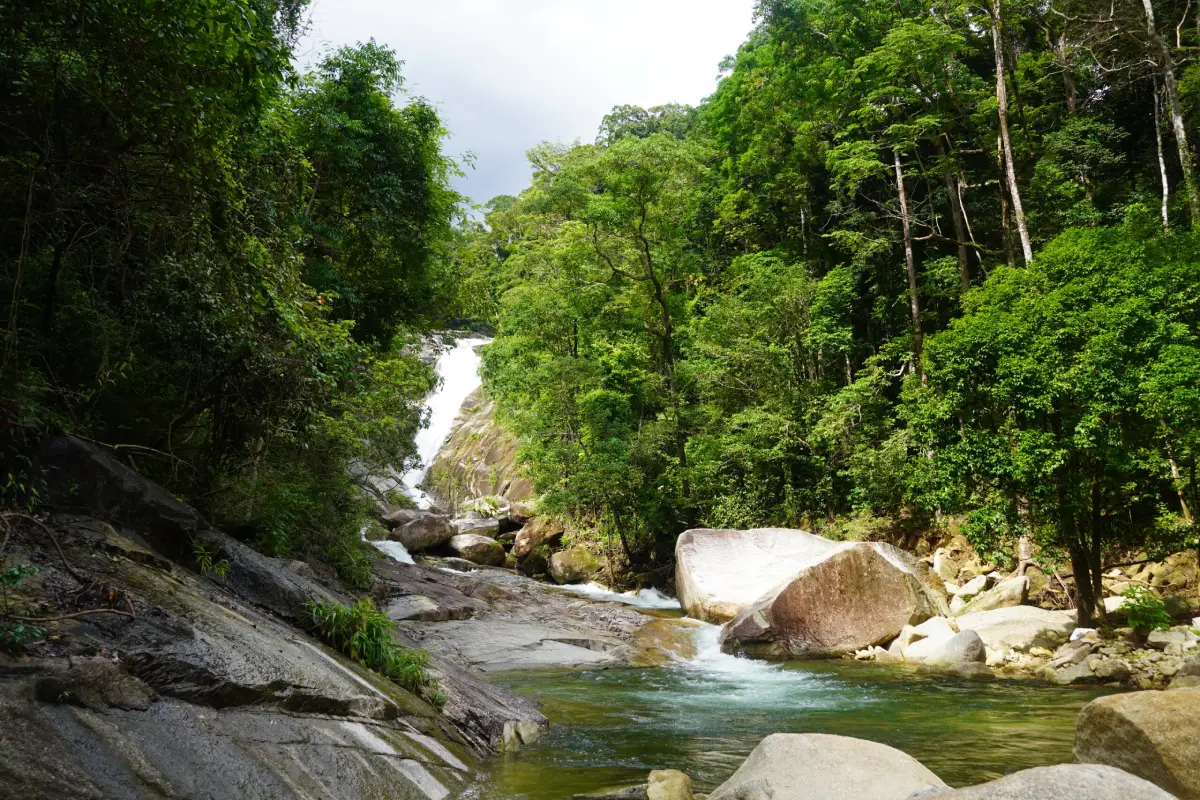
Sai Rung Waterfall in Trang Province is a natural waterfall in Moo 4, Na Chum Het Subdistrict, Yan Ta Khao District. It lies within Khao Banthat Wildlife Sanctuary and is known for a single cascade falling from a high cliff into a pool below. When sunlight meets the fine mist from the waterfall at the right angle, a rainbow-like shimmer appears in front of the falling water. This natural effect gives the waterfall its name, “Sai Rung,” meaning rainbow.
Sai Rung Waterfall is a suitable destination for travelers who want a quiet inland nature experience in Trang. The waterfall is not defined by multiple tiers, but by the clear vertical movement of water from a high rock face, the mist created at the base, and the shaded forest atmosphere around the stream. The lower pool has several shallow sections, making the area suitable for families when adults supervise children closely.
The waterfall is part of the wider Banthat Mountain Range landscape, one of the important mountain systems of southern Thailand. This range supports headwater forests, streams, waterfalls, wildlife habitats, and rural communities. A visit to Sai Rung Waterfall is therefore not only a short swimming stop, but also a way to experience the mountain and watershed side of Trang Province.
Na Chum Het Subdistrict is connected with the forested edge of Khao Banthat Wildlife Sanctuary. The area includes agricultural communities, rubber plantations, oil-palm farms, village roads, streams, and several nature routes. For travelers who already know Trang for islands, beaches, and food in the city, Sai Rung Waterfall introduces a different side of the province: inland forest, mountain water, and local countryside scenery.
The main feature of Sai Rung Waterfall is its single high cascade. Water drops from the cliff into a pool and stream below, surrounded by rocks and humid southern forest. On sunny days, the mist can reflect the sunlight and create a rainbow effect. This simple but memorable natural phenomenon makes Sai Rung Waterfall especially attractive for photography and slow nature travel.
The best chance of seeing the rainbow effect is on a bright day with clear sunlight and enough spray from the waterfall. Late morning to afternoon usually gives visitors a better chance of seeing light hitting the mist. Even when the rainbow does not appear, the waterfall remains attractive because of its cliff, stream, pool, rocks, and green forest setting.
Sai Rung Waterfall has water throughout the year. During the rainy season and shortly after rainfall, the waterfall often has stronger flow and more mist, while the surrounding forest looks greener and fresher. Drier periods are usually easier for families and visitors who prefer calmer conditions. Because the waterfall is inside a protected forest landscape, travelers should check weather conditions and official notices during heavy rain periods.
The lower pool is the easiest area for general visitors to enjoy. It allows visitors to rest, take photos, and swim in safer sections. However, natural waterfalls are not the same as built swimming pools. Rocks can be slippery, water depth can change suddenly, and the current can become stronger after rain. Children should remain close to adults at all times, and visitors should avoid the strongest flow and wet rock edges.
For photographers, Sai Rung Waterfall offers several useful compositions: a wide view of the cliff and falling water, close-up scenes of spray and light, the lower pool with rocks and tree shade, and the forest around the stream. Photography should always be done from safe ground. Do not climb wet rocks or stand in fast-flowing water just to take a photo.
The waterfall also has geological value. It is located within the Banthat Mountain Range, and the rock around the waterfall is associated with porphyritic granite from the Triassic period. Water erosion along natural rock fractures helped create the steep waterfall face. This makes Sai Rung Waterfall a useful outdoor learning site for understanding how water, stone, time, and landform development work together.
Sai Rung Waterfall is managed within Khao Banthat Wildlife Sanctuary under Thailand’s Department of National Parks, Wildlife and Plant Conservation. Visitors should treat the area as a conservation zone. Do not leave rubbish, use soap or shampoo in the stream, catch aquatic animals, pick plants, feed wildlife, or make loud noise. Responsible behavior helps protect the stream, forest, and wildlife habitat.
The waterfall suits several types of travelers: families, small groups, nature photographers, waterfall lovers, and visitors looking for a calm place outside Trang city. Families should stay in the lower and safer sections. Visitors who want to see the rainbow effect should choose a sunny day. Travelers who prefer quiet surroundings should arrive in the morning or on a weekday.
A simple visit can take about 1 hour for walking, resting, photography, and enjoying the pool area. Visitors who plan to swim or sit by the stream may want to spend longer. Practical items to bring include non-slip shoes, quick-dry clothing, a towel, spare clothes, drinking water, insect repellent, waterproof protection for phones, and a personal rubbish bag.
Sai Rung Waterfall is also useful as part of a wider Yan Ta Khao waterfall route. Nearby and connected nature options include Phrai Sawan Waterfall, Lam Plok Waterfall, Ton Tok Waterfall, and Ton Te Waterfall. A half-day trip can focus on Sai Rung Waterfall alone, while a full-day trip can combine 2 or 3 waterfalls depending on weather, road conditions, and available time.
Phrai Sawan Waterfall is a nearby option for travelers who want to continue through a forest-and-waterfall route. Lam Plok Waterfall is another distinctive site, known for its multi-tier waterfall and the Khlong Lam Plok Hydroelectric Power Project. Ton Tok and Ton Te waterfalls are suitable for visitors who want a larger waterfall landscape and a deeper sense of the Banthat forest environment.
A good itinerary begins from Trang city in the morning. Travelers can have breakfast or prepare snacks before driving toward the Trang–Phatthalung road. At kilometer 17, turn right onto the Ban Ka Chong–Ban Hat Lao route for about 12 km, then turn left at the Sai Rung Waterfall sign and continue for about 3 km. Starting early gives enough time to swim, take photos, rest, and return before evening.
Getting There is most convenient by private car or rental car. From Trang city, take the Trang–Phatthalung road to kilometer 17, turn right onto the Ban Ka Chong–Ban Hat Lao road for about 12 km, then turn left at the waterfall sign and continue for about 3 km. The route leads into a rural natural area, so careful driving is recommended, especially during rain or on wet roads.
Travelers without a private vehicle should arrange local transport in advance. Public transportation does not conveniently reach the waterfall entrance. Hiring a local vehicle is more practical, especially for visitors who also want to stop at restaurants, accommodation, or nearby waterfalls in Yan Ta Khao and Palian districts.
Safety should be a priority at Sai Rung Waterfall. Khao Banthat Wildlife Sanctuary has previously closed waterfall nature sites temporarily during periods of heavy rain for visitor safety. Travelers should avoid swimming during continuous rain, leave the water if it becomes unusually muddy or forceful, and follow official instructions during the monsoon season.
Visitors should stay on used routes, avoid entering deep forest without local or official guidance, avoid throwing food into the water, avoid lighting fires in risky areas, and protect personal belongings from water. Elderly visitors should stay in easy-access areas, while children should wear secure footwear and remain near adults.
Food and drink planning is also useful. Shops in natural areas may vary by day and season, so travelers should prepare drinking water and light snacks before entering the waterfall route. Any rubbish must be taken back out, including plastic bottles, food packaging, tissues, and disposable containers.
For accommodation, travelers can stay in Yan Ta Khao or Palian districts for easier access to the waterfall route, or stay in Trang city for greater convenience with restaurants, the railway station, the airport, and city services. The best choice depends on the full itinerary rather than the waterfall alone.
Sai Rung Waterfall is also a simple learning destination. Children can observe how sunlight, water spray, and viewing angle create a rainbow effect. Adults can rest beside the stream, and photographers can study natural light and moving water. The same place can provide recreation, outdoor learning, and family time.
Overall, Sai Rung Waterfall deserves a place on a Trang nature itinerary. It offers a high single cascade, a pool suitable for careful water play, the chance to see a rainbow effect in the spray, a shaded forest setting inside Khao Banthat Wildlife Sanctuary, and convenient links to other waterfalls in Yan Ta Khao and Palian. Travelers who want to understand Trang beyond the sea should include Sai Rung Waterfall in their inland mountain-and-water route.
The best experience comes with proper planning: travel on a safe-weather day, start in the morning, use a vehicle suitable for rural roads, and allow enough time to enjoy the area without rushing. The value of Sai Rung Waterfall is not only a quick photo, but the sound of water, the mist catching sunlight, the green forest, and the calm feeling of a southern Thai headwater landscape.
| Name | Sai Rung Waterfall |
| Location | Moo 4, Na Chum Het Subdistrict, Yan Ta Khao District, Trang Province 92140 |
| Coordinates | 7.440320, 99.813650 |
| Highlights | A single high-cliff waterfall where sunlight can create a rainbow effect in the mist |
| Distinctive Features | Lower natural pool with several shallow sections, suitable for relaxation, careful swimming, photography, and forest nature travel |
| Protected Area | Khao Banthat Wildlife Sanctuary, Department of National Parks, Wildlife and Plant Conservation |
| Local Importance | A nature attraction in the Banthat Mountain Range, valuable for recreation, outdoor learning, headwater forest awareness, and waterfall-landform observation |
| Geological Features | The waterfall area is associated with Triassic porphyritic granite and was formed through water erosion along natural rock fractures |
| Travel Information | From Trang city, take the Trang–Phatthalung road to kilometer 17, turn right onto the Ban Ka Chong–Ban Hat Lao route for about 12 km, then turn left at the waterfall sign and continue for about 3 km |
| Current Status | Open as a natural attraction within Khao Banthat Wildlife Sanctuary, with possible temporary safety closures during severe weather |
| Open Days | Daily |
| Opening Hours | 08.00 – 17.00 |
| Fees | No admission fee |
| Estimated Visit Duration | About 1 hour, or longer for swimming and streamside relaxation |
| Main Areas / Zones | Entrance area, streamside rest area, lower pool, waterfall cliff, rainbow-viewing point, short walking route near the waterfall, and seasonal food and souvenir area |
| Caretaker / Coordinator | Khao Banthat Wildlife Sanctuary, Department of National Parks, Wildlife and Plant Conservation |
| Tourism Information Contact | Tourism Authority of Thailand, Trang Office, Tel. +66 75 215 867 / Forest and Marine Protection Hotline, Tel. 1362 |
| Nearby Tourist Attractions | 1. Phrai Sawan Waterfall, about 8 km 2. Lam Plok Waterfall, about 12 km 3. Ton Tok Waterfall, about 18 km 4. Ton Te Waterfall, about 22 km 5. Khao Banthat Wildlife Sanctuary, about 1 km 6. Hat Yao Beach, about 40 km |
| Nearby Restaurants | 1. Tamle Thong Thung Yao, about 22 km, Tel. +66 83 642 9515, +66 97 359 8682, +66 82 318 4873 2. Steak A-Fai, about 23 km, Tel. +66 81 740 9738 3. Waan Waan Dim Sum, about 25 km, Tel. +66 96 398 2656 4. Por Prapa Yan Ta Khao, about 25 km, Tel. +66 90 973 8582 5. Kung Fu Chicken Rice Yan Ta Khao, about 25 km, Tel. +66 81 892 6715, +66 64 110 4315 6. Ko Libong Restaurant Yan Ta Khao, about 26 km, Tel. +66 75 281 430, +66 75 281 888 |
| Nearby Accommodations | 1. Cupid Hotel, about 25 km, Tel. +66 83 692 6888 2. Trang Villa Hotel and Water Park, about 30 km, Tel. +66 95 419 5536 3. Bai Prae Resort, about 30 km, Tel. +66 81 748 7273 4. PK Inn Hotel, about 30 km, Tel. +66 75 584 184 5. Rimlay Boutique Homestay, about 50 km, Tel. +66 83 693 3444 6. HOP INN Trang, about 45 km, Tel. +66 2 080 2222 |
Frequently Asked Questions (FAQ)
Q: Where is Sai Rung Waterfall located?
A: Sai Rung Waterfall is located in Moo 4, Na Chum Het Subdistrict, Yan Ta Khao District, Trang Province, within Khao Banthat Wildlife Sanctuary.
Q: What are the opening hours of Sai Rung Waterfall?
A: Sai Rung Waterfall is open daily from 08.00 to 17.00. During heavy rain periods, travelers should check official safety notices before visiting.
Q: Is there an admission fee for Sai Rung Waterfall?
A: No. There is no admission fee for Sai Rung Waterfall.
Q: Why is it called Sai Rung Waterfall?
A: The name comes from the rainbow-like effect that appears when sunlight hits the mist from the waterfall at the right angle.
Q: Can visitors swim at Sai Rung Waterfall?
A: Yes. Visitors can swim in the lower pool and safe sections, but should avoid slippery rocks, strong currents, and heavy-rain conditions.
Q: How do I get to Sai Rung Waterfall from Trang city?
A: Take the Trang–Phatthalung road to kilometer 17, turn right onto the Ban Ka Chong–Ban Hat Lao road for about 12 km, then turn left at the waterfall sign and continue for about 3 km.
Q: Is Sai Rung Waterfall suitable for families?
A: Yes. The lower pool has several shallow sections, but adults should supervise children closely at all times.
Q: What should visitors bring to Sai Rung Waterfall?
A: Visitors should bring non-slip shoes, quick-dry clothes, a towel, spare clothes, drinking water, insect repellent, waterproof protection, and a personal rubbish bag.
 Category: ●Nature and Wildlife
 Group: ●Waterfalls
Last Update : 2 MonthAgo
 Last Update : 2 MonthAgo
 Click to Access the Navigation Map GPS
Sai Rung Waterfall Map
Recommend

 Art, Culture and Heritage
 Historical Sites and Monuments(1)
 Landmarks and Memorials(2)
 Art, Craft Centres, Tradition(3)
 Museums(2)
 Places of Worship
 Temple(15)
 Mosque(1)
 Other Sacred Sites(7)
 Research and Development
 Royal Project(1)
 Suburban Living
 Village, Community(5)
 National Parks and Marine Reserves(6)
 Mountain (Doi)(8)
 Dam, Reservoir, Lake(1)
Waterfalls(20)
 Hot Springs(1)
 Caves(11)
 Bays and Beaches(11)
 Islands(12)
 Other natural attractions(3)
 Entertainment and Agricultural
 Farms, Parks and Ecotourism(8)
 Outdoor and Adventure Activities(1)
 Travel Articles, Recipes
 Travel Review, Food Review(1)
 Southern Food Menu, Southern Food Recipes(1)


