
lovethailand home >South Travel Attractions >Phatthalung Travel Attractions >Pa Bon >Nong Thong > Nong Thong Sea of Mist
TL;DR: Nong Thong Sea of Mist, Phatthalung attractions : Nature and Wildlife, Other natural attractions.

Nong Thong Sea of Mist
Open Days: This natural and community-based area can be visited depending on weather and route safety.
Opening Hours: Early morning to morning is recommended. Visitors should contact the local authority before traveling.
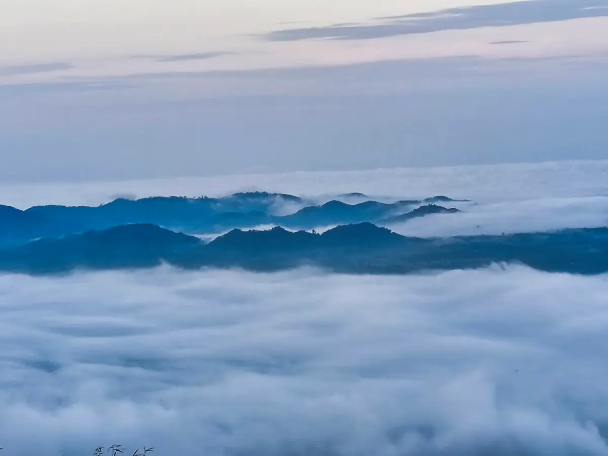
Nong Thong Sea of Mist, also known as Pha Mai Kaen Viewpoint, is located in Moo 1, Nong Thong Subdistrict, Pa Bon District, Phatthalung Province. Set along the Banthat Mountain Range, it is a natural viewpoint for travelers who enjoy mountains, morning mist, forest landscapes, and quiet community-based travel. The main highlight is the early morning sea of mist that covers the valley below. On clear days, the view opens toward the lowland areas and the direction of Songkhla Lake, giving visitors a rare perspective that connects mountains, forest, community, and watershed landscapes in one scene.
Pha Mai Kaen Viewpoint is part of the Banthat Mountain Range, an important mountain system in southern Thailand and a key source of water for communities in Pa Bon District. The surrounding environment includes forested hills, streams, waterfalls, fruit gardens, and agricultural communities close to the forest edge. A visit to Nong Thong Sea of Mist is therefore not only about seeing fog, but also about understanding how the Banthat Mountains support water, farming, community livelihoods, and local tourism in Nong Thong.
The atmosphere of Nong Thong Sea of Mist is very different from Phatthalung’s better-known lakeside or urban attractions. Visitors usually begin before dawn in order to reach the viewpoint when the mist is still floating across the valley. After parking, travelers walk up to the viewpoint and are rewarded with soft layers of white mist, forest ridges, and mountain silhouettes. The experience is ideal for nature photography, quiet reflection, and a refreshing start to the day in the mountain air.
Nong Thong is part of Pa Bon District, an area directly connected with the Banthat Range. The district contains streams, waterfalls, and watershed forests that are important to local communities. Water from the mountain areas feeds streams and eventually connects with the wider Songkhla Lake watershed. This makes the viewpoint meaningful beyond its scenery: it shows how Phatthalung’s lake system is linked with mountain forests, headwater streams, and rural communities.
Pha Mai Kaen Viewpoint is suitable for travelers who prefer natural places without heavy commercial development. Its charm lies in simplicity: mountain air, morning mist, local roads, and a community landscape. Visitors should prepare properly, including checking the weather, wearing suitable shoes, carrying drinking water, and contacting local people or the local authority before traveling. Mist conditions depend on weather, humidity, wind, and rainfall, so every visit may look different.
The best period for seeing mist is generally during the rainy-to-cool season and on humid mornings. Some days may bring thick white fog filling the valley, while other days may show only light mist or clear mountain views. Even when the mist is not dense, the viewpoint still offers a calm and refreshing natural atmosphere with views across the forested landscape of Pa Bon.
When the mist is beautiful, it spreads across the valley and gradually shifts as sunlight reaches the mountain ridge. The changing light reveals layers of forest, hills, and communities below. This makes Nong Thong Sea of Mist a strong location for wide landscape photography, sunrise photos, and nature-focused travel content that emphasizes peace rather than crowds.
Several natural attractions are located near Nong Thong Sea of Mist, including Ton Sato Waterfall, Mae Taeng Waterfall, and Lat Toei Waterfall. Ton Sato Waterfall, in Moo 1, Nong Thong Subdistrict, is connected with Ban Mueang Takua community and is known as a natural site within the watershed forest. Combining the viewpoint with nearby waterfalls helps travelers experience both the high mountain view and the close-up freshness of streams and forest water.
Ton Sato Waterfall is important to the local community as a natural recreation site and a symbol of watershed conservation. Visitors should avoid littering, avoid entering streams during heavy rain, and avoid walking into forest routes without local guidance. Responsible travel is essential in this area because the waterfalls, streams, and forested hills are part of the community’s living environment, not only tourist scenery.
The Nong Thong and Banthat Mountain area is also associated with the Mani people, an indigenous forest-dwelling group in southern Thailand. Local travel information mentions temporary forest shelters, or thap, used by Mani groups in mountain forest areas. Visitors should approach this subject with respect. The purpose of travel should not be to intrude on people or treat them as an attraction, but to understand that the Banthat forest has long been a living landscape for many groups of people.
When discussing the Mani people, some Thai travelers may connect the topic with the historical figure Khanang from the reign of King Rama V. For present-day travel, the important point is respect. Visitors should not photograph people without permission, should not enter private or sensitive areas, and should avoid presenting local ethnic communities in a sensational way. Responsible tourism recognizes both the dignity of people and the ecological importance of the forest.
Nong Thong also has a strong agricultural identity. The area includes rubber plantations, oil palm, orchards, and mixed farming close to the mountain foothills. One well-known community-based attraction is Lung Than Salak Garden, which reflects how local agriculture can become part of a travel experience. Travelers who have time after seeing the mist can continue to orchard-based activities or local community stops to add food, farming, and livelihood dimensions to the trip.
Getting There is easiest by private car. From Phatthalung city, take Highway 4, Phetkasem Road, toward Pa Bon District. At Pa Bon traffic light intersection, turn toward Nong Thong Subdistrict and Ban Mueang Takua. The viewpoint is about 12 km from Pa Bon town and about 50 km from Phatthalung city. After parking, visitors continue on foot to the viewpoint. Route conditions should be checked locally, especially during the rainy season or after heavy rain.
The final approach is a local road near mountain terrain. Drive carefully before dawn because visibility may be low and road surfaces may be damp. Check headlights, brakes, and fuel before leaving. Travelers who are unfamiliar with the route should go in a group or arrange local guidance. Good planning makes it easier to arrive safely before sunrise.
Travelers who want the best chance of seeing the mist should stay in Pa Bon or a nearby area the night before and leave before dawn. A same-day trip from Phatthalung city is possible, but it requires an early start and extra time for the mountain road and the walk after parking. A full-day itinerary can begin with Nong Thong Sea of Mist, continue to Ton Sato Waterfall or a local orchard, and end with a restaurant or café in Pa Bon.
Useful items include a flashlight or headlamp, non-slip shoes, a light windbreaker, drinking water, mosquito repellent, a camera, a trash bag, and a fully charged phone. During the rainy season, bring a light raincoat and a waterproof bag for electronic devices. Carry only what is necessary because the final section requires walking uphill.
Visitors should avoid entering forest routes, waterfalls, or community areas without clear information. The Banthat Range contains headwater forests, streams, and natural routes that can change with the season. If the water in a stream turns muddy, rises quickly, or sounds unusually strong, move away from the water immediately. Flash floods and slippery routes are important risks in southern mountain areas, especially during or after rain.
Nong Thong Sea of Mist is best for travelers seeking peace rather than entertainment. The morning air, natural sounds, and misty views make it suitable for photographers, families, small groups, and nature lovers. Older visitors can enjoy the trip if the walking route is suitable and assistance is available. Children should remain under adult supervision because viewpoint and forest routes may include uneven ground or height differences.
Facilities at the viewpoint are limited because this is a natural and community-based site rather than a large developed attraction. Visitors should bring basic supplies and take all rubbish back down. Those who want accommodation, meals, or community activities should use local services in Nong Thong, Pa Bon, or nearby areas and contact providers in advance where possible.
This route can be combined with several attractions in southern Phatthalung, such as Ton Sato Waterfall, Lung Than Salak Garden, Pa Bon Reservoir, Sumano Cave, or onward routes toward Tamot and Khao Chaison. With good planning, travelers can experience mist, forest, waterfalls, orchards, and local food within 1 or 2 days.
In summary, Nong Thong Sea of Mist is more than a mist-viewing spot. It is an entry point to understanding Pa Bon as a watershed landscape where forest, mountains, communities, agriculture, and cultural memory are closely connected. Travelers who arrive with respect and preparation will find not only a beautiful view, but also a deeper appreciation of the Banthat Mountain Range and its importance to Phatthalung.
| Name | Nong Thong Sea of Mist / Pha Mai Kaen Viewpoint |
| Location | Moo 1, Nong Thong Subdistrict, Pa Bon District, Phatthalung Province |
| Address | Ban Mueang Takua area, Moo 1, Nong Thong Subdistrict, Pa Bon District, Phatthalung Province 93170, Thailand |
| Highlights | Morning sea of mist over the Banthat Mountain Range, with views over valleys, lowland areas, and the direction of Songkhla Lake on clear days |
| History | A natural viewpoint connected with Nong Thong community tourism, Ban Mueang Takua, Ton Sato Waterfall, and the watershed forest landscape of the Banthat Mountain Range |
| Distinctive Features | A natural mountain viewpoint with morning mist, cool air, forest scenery, a walking route from the parking area, and nearby waterfalls |
| Travel Information | From Phatthalung city, take Highway 4 to Pa Bon District. At Pa Bon traffic light intersection, turn toward Nong Thong Subdistrict. The viewpoint is about 12 km from Pa Bon town and about 50 km from Phatthalung city. After parking, visitors walk up to the viewpoint. |
| Current Status | Still listed as a Nong Thong natural attraction and appears in LoveThailand.org travel information. Visitors should contact the local authority before traveling to confirm route and safety conditions. |
| Open Days | This natural and community-based area can be visited depending on weather and route safety. |
| Opening Hours | Early morning to morning is recommended. Visitors should contact the local authority before traveling. |
| Fees | No confirmed official entrance fee found. |
| Facilities | Parking before the walking route, basic community services in Nong Thong, and restaurants or accommodations in Pa Bon District |
| Main Areas / Zones | Pha Mai Kaen Viewpoint, walking route to the viewpoint, Ban Mueang Takua, Ton Sato Waterfall, and Nong Thong community-based tourism areas |
| Caretaker / Local Authority | Nong Thong Subdistrict Administrative Organization, Pa Bon District, Phatthalung Province |
| Main Contact Number | Nong Thong Subdistrict Administrative Organization, Tel. 074-685-786 |
| Official Website / Official Page | Nong Thong Subdistrict Administrative Organization website |
| Nearby Tourist Attractions | 1. Ton Sato Waterfall, about 5 km 2. Lung Than Salak Garden, about 8 km 3. Pa Bon Reservoir, about 15 km 4. Nan Fa Waterfall, about 18 km 5. Manora Waterfall, about 25 km 6. Sumano Cave, about 35 km |
| Nearby Restaurants | 1. Nong Thong Station, Nong Thong Subdistrict, about 12 km, Tel. 084-774-5494 2. Ko'made Cafe&Restaurant, Pa Bon, about 18 km, Tel. 082-889-7898 3. Friendship Coffee & Bar, Pa Bon, about 20 km, Tel. 062-037-1451, 099-235-0299 4. Phak Phing Ing Thang Coffee, Pa Bon, about 21 km, Tel. 074-841-638, 083-020-0703 5. Bang Meen Kai Ob Ong, Pa Bon branch, about 20 km, Tel. 089-291-2851 |
| Nearby Accommodations | 1. Baan Baan Homestay Phatthalung, Nong Thong Subdistrict, about 12 km 2. Lung Than Salak Garden Homestay, Nong Thong Subdistrict, about 8 km 3. Dahla Resort, Pa Bon, about 20 km, Tel. 061-990-0676 4. Sanfhan Resort, Khao Chaison, about 38 km 5. Ozone Resort & Pool Villa, Khao Chaison, about 42 km, Tel. 074-611-777 |
Frequently Asked Questions (FAQ)
Q: Where is Nong Thong Sea of Mist located?
A: Nong Thong Sea of Mist, also known as Pha Mai Kaen Viewpoint, is located in Moo 1, Nong Thong Subdistrict, Pa Bon District, Phatthalung Province, along the Banthat Mountain Range.
Q: What is the highlight of Nong Thong Sea of Mist?
A: The main highlight is the early morning sea of mist over the valley, with mountain scenery and views toward the lowland areas and Songkhla Lake on clear days.
Q: What is the best time to visit?
A: Early morning is the best time, especially before and shortly after sunrise when mist conditions are most likely.
Q: How do visitors get there?
A: From Phatthalung city, take Highway 4 to Pa Bon District, turn toward Nong Thong Subdistrict at Pa Bon traffic light intersection, and continue toward the viewpoint. After parking, visitors walk up to the viewpoint.
Q: Is there an entrance fee?
A: No confirmed official entrance fee has been found. Visitors should prepare cash for transport, food, drinks, or community services if arranged locally.
Q: Who is Nong Thong Sea of Mist suitable for?
A: It is suitable for nature lovers, photographers, families, small groups, and travelers interested in community-based and conservation-minded travel.
Q: What nearby places can be visited together with Nong Thong Sea of Mist?
A: Nearby places include Ton Sato Waterfall, Lung Than Salak Garden, Pa Bon Reservoir, Nan Fa Waterfall, Manora Waterfall, and Sumano Cave.
Q: What should visitors be careful about?
A: Visitors should check the weather, drive carefully before dawn, wear suitable shoes, avoid littering, avoid entering forest or waterfall routes without local guidance, and stay away from streams during heavy rain.
 Category: ●Nature and Wildlife
 Group: ●Other natural attractions
Last Update : 2 MonthAgo
 Last Update : 2 MonthAgo
 Click to Access the Navigation Map GPS
Nong Thong Sea of Mist Map
Recommend

 Art, Culture and Heritage
 Historical Sites and Monuments(1)
 Landmarks and Memorials(1)
 Art, Craft Centres, Tradition(6)
 Historic Homes and Cities(1)
 Educational Places
 Educational Gardens, Farm(1)
 Places of Worship
 Temple(25)
 Other Sacred Sites(4)
 Research and Development
 Royal Project(2)
 Suburban Living
 Village, Community(3)
 National Parks and Marine Reserves(3)
 Mountain (Doi)(4)
 Dam, Reservoir, Lake(7)
 Waterfalls(16)
 Hot Springs(2)
 Caves(12)
 River, Canal(5)
 Bays and Beaches(6)
 Islands(2)
Other natural attractions(4)
 Entertainment and Agricultural
 Farms, Parks and Ecotourism(4)
 Travel Articles, Recipes
 Travel Review, Food Review(1)


