
lovethailand home >North Travel Attractions >Mae Hong Son Travel Attractions >Sop Moei >Mae Suat > Mae Ngao National Park
TL;DR: Mae Ngao National Park, open The park office and designated visitor areas operate according to announcements.
Mae Ngao National Park
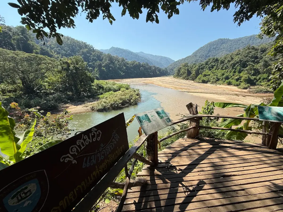
Open Days: The park office and designated visitor areas operate according to announcements issued by Mae Ngao National Park. Rafting, boat trips and forest access depend on water levels, weather conditions and permission from park authorities.
Mae Ngao National Park, Mae Hong Son Province, Thailand, is a protected natural landscape distinguished by the exceptionally clear Ngao River, complex mountain ranges, watershed forests, waterfalls and riverside communities. The conservation area extends across Sop Moei and Mae Sariang districts in Mae Hong Son Province and into parts of Tha Song Yang District in Tak Province. The principal visitor area is located near Ban Mae Ngao, Mae Suat Subdistrict, Sop Moei District. Its best-known attractions include bamboo rafting along the Ngao River, camping beside the water, viewing the meeting of the Ngao and Yuam rivers, and experiencing the forested mountains of northwestern Thailand.
Mae Ngao is officially administered as a national park under establishment by Thailand's Department of National Parks, Wildlife and Plant Conservation. Published tourism information describes a conservation area of approximately 257,650 rai, or around 412 square kilometers. Most of the landscape consists of mountains, valleys and forested watersheds. The area is important for biodiversity, freshwater systems and nature tourism connected with the river and surrounding forests.
What makes Mae Ngao especially attractive is the natural character of a relatively narrow river winding through forested valleys. Its course includes rocky rapids, sandy banks and calmer stretches of water. Different sections offer different scenery and water conditions. Some are suited to quiet riverside observation, while others form part of managed water activities. Visitors can enjoy the surrounding landscapes both from the riverbank and from rafting or boating excursions when these services are authorized and safe.
The park's headquarters area is associated with shaded riverside surroundings, large trees and nearby forest. This environment appeals particularly to travelers who enjoy simple outdoor recreation and camping. Mornings can be cool and quiet, accompanied by the sounds of flowing water and birds. In the late afternoon, changing sunlight illuminates the mountain slopes, creating an atmosphere different from that of more heavily developed tourist destinations.
History of Mae Ngao National Park is closely connected with efforts to protect the Ngao River watershed and the adjoining mountain forests stretching between Mae Hong Son and Tak provinces. The area is significant as the source of numerous streams and as habitat for diverse plants and wildlife. Surveys and conservation planning have therefore aimed to maintain the natural resources while considering appropriate uses by surrounding communities.
Historically, the Ngao River and its surrounding forests were connected with transportation between communities located in mountain valleys. Long-tail boats have been used along certain sections to move people and agricultural products. River travel has been particularly relevant where mountainous terrain limits road access. The waterway therefore represents not only a scenic attraction but also a practical element of local life.
Tourism development in Mae Ngao has been influenced by the river's clarity and the appearance of the forests along both banks. Bamboo rafting and riverside camping gradually became recognized experiences. At the same time, conservation authorities have responsibilities involving forest protection, prevention of illegal encroachment, wildfire control and visitor management appropriate to the natural environment.
The national park establishment process also concerns boundaries and areas traditionally used by local communities. In 2025, Thailand's National Human Rights Commission addressed the proposed park's management and emphasized public participation in the consideration of residential land, agricultural areas, spiritual sites and community forests. The administration of Mae Ngao therefore includes both environmental conservation and the social and cultural relationships between communities and the surrounding forest.
Another continuing responsibility is maintaining safety in forest areas and along important transport routes. Highway 105 connects Sop Moei District with Mae Sot in Tak Province. In April 2025, Mae Ngao park personnel worked with other agencies and local residents to reopen a section of the highway after a wildfire damaged the base of a large roadside tree, causing it to fall across the road. The incident demonstrated how forest protection and wildfire management are directly connected with transportation and community safety.
Origin of the Name Ngao River is associated with the clarity of its water. Under suitable conditions, reflections and objects beneath the surface can be seen clearly. The river's appearance depends on water flow, suspended sediment and the season, but its clear water has long been one of the defining characteristics reflected in its name.
Geography of Mae Ngao National Park is dominated by rugged mountains, forested valleys and natural waterways. Its vegetation changes according to elevation and moisture conditions. Major forest types include hill evergreen forest, dry evergreen forest, pine forest, mixed deciduous forest and dry dipterocarp forest. The diversity of terrain provides different habitats for wildlife and contributes to the watersheds of the Ngao, Yuam and Rit rivers.
Several mountains stand out within the wider landscape. Doi Pui Luang is described at an elevation of approximately 1,498 meters above sea level, Doi Soe Thoe Lu at approximately 1,622 meters, and Doi Khui Luang at more than 1,678 meters. Variations in altitude affect temperature, humidity and vegetation. The ecological conditions of high mountain forests therefore differ substantially from those of the river valleys below.
Mountain valleys collect rainfall from surrounding slopes. Small streams gradually join larger waterways as they descend through the terrain. This process contributes water to the Ngao River from different parts of the watershed and explains why water levels can change after rainfall in the upper mountains, even when the immediate visitor area experiences no rain.
The Ngao River is the central natural feature of the national park. A section of approximately 42 kilometers is associated with the conservation landscape. The river varies in width according to the terrain, with published descriptions giving widths of approximately 10–20 meters along many sections. Its winding course passes rocky rapids, sandbanks and forested valleys before meeting the Yuam River.
The most remarkable characteristic of the Ngao River is the clarity of the water and the visibility of stones or sand beneath the surface during suitable conditions. Flowing water produces different sounds as it passes through rocky sections and wider pools. Walking along the bank reveals the variety of river environments, including gravel beds, sandy banks and natural rock formations.
Both banks are bordered by trees, shrubs and mountain slopes connected to the surrounding forests. The vegetation provides shade and forms an important part of the scenery experienced during rafting. From water level, visitors can observe forests rising above the river and hills appearing around successive bends.
The Two-Colored River at Sop Ngao is among the best-known natural viewpoints in the area. Here, the Ngao River joins the Yuam River. The waterways may have visibly different colors because of variations in suspended sediment and rainfall conditions in their respective watersheds. The Ngao River can appear relatively clear, while the Yuam River may carry brownish sediment, creating a visible contrast where the currents meet.
The two-colored water phenomenon results from differences in turbidity and sediment concentration. As the rivers merge, turbulence gradually mixes the water, reducing the contrast farther downstream. The visibility of the boundary varies with weather, rainfall and river conditions. The colors are therefore not identical on every visit.
The confluence is also an educational natural landmark. Visitors can observe how two rivers with different water characteristics meet and combine. Forests and mountains surrounding the junction create an atmosphere different from urban riverside viewpoints and reveal the importance of interconnected watershed systems.
Bamboo Rafting on the Ngao River has long been one of the area's recognized tourist activities. Traveling on a raft provides views of forested banks, rocky sections, sandy shores and mountains appearing around the river bends. The experience is closely connected with the natural course of the river and its changing flow.
Bamboo rafts are traditionally constructed using natural bamboo stems tied together to form a floating platform. A knowledgeable raft operator controls movement and direction. The activity requires careful assessment of water depth, current speed and passenger safety because river conditions can change after rain. Availability depends on the season and the operating arrangements established in the area.
Tourism information has described June through January as a suitable general period for river activities, but rafting schedules are determined by actual river conditions and management decisions each year. High water can create strong currents, while the dry season may expose shallow sections and rocks. Consequently, routes and travel times can vary considerably.
Long-Tail Boat Travel Along the Ngao River represents another form of river transportation. Boats have served villages and transported agricultural goods along navigable sections of the waterway. A route between the bridge-area landing point and Ban Sop Khong is among those described in tourism information. Boat journeys reveal both natural scenery and the practical importance of river access to local communities.
Local river transport differs from scheduled sightseeing cruises in major tourist destinations. Departure times can depend on community needs, passenger arrangements and water levels rather than fixed timetables. Visitors should recognize the importance of local operating conditions and appropriate safety equipment when considering boat travel.
Sandbanks and Rocky Rapids are characteristic river features shaped by sediment movement. Sand and gravel accumulate along slower sections, particularly on the inner sides of bends, forming exposed banks when water levels fall. Large rocks in the river create turbulence and faster currents, adding variety to the river scenery.
Riverbanks are transitional habitats connecting freshwater and forest ecosystems. Some animals use these areas for feeding or moving between habitats. Visitors should avoid leaving plastic or food waste near the water because rubbish can be carried downstream and affect communities and wildlife beyond the immediate visitor area.
Camping at Mae Ngao National Park is associated with grassy areas and shade from large trees near the park office. The riverside atmosphere differs from high-altitude camping because visitors can hear running water and enjoy the surrounding forest at close range. This makes the area attractive for travelers who enjoy simple overnight stays in natural surroundings.
Riverside camping requires careful attention to water levels and upstream rainfall. Even without local rain, heavy storms farther upstream can cause a river to rise. Tents must therefore be pitched only in designated areas, not on low-lying sandbanks or flood-prone ground. Campers should keep their equipment organized and remain prepared for changing weather.
Mornings beside the Ngao River are often peaceful, allowing visitors to listen to birds and observe the forest. During the day, shaded areas provide comfortable places to relax near the water. An overnight visit offers more time to appreciate changing light, reflections and the atmosphere of the river than a brief stop.
Visitor Facilities Near the Park Office have been described in published tourism information as including accommodation, camping grounds and a park welfare restaurant. These services provide a foundation for nature tourism. Their actual operation is subject to staffing, maintenance and the park's arrangements at the time of a visit.
Mixed Deciduous Forest is one of the principal forest environments at Mae Ngao. It contains various tree species growing together, many of which respond to seasonal changes by shedding leaves during dry periods. Vegetation becomes greener and the forest environment more humid during the rainy season. These annual cycles create significant changes in forest appearance and light conditions.
Dry Evergreen and Hill Evergreen Forests are important for biodiversity conservation. Dry evergreen forests can maintain dense green vegetation where sufficient moisture is available. Hill evergreen forests occur in higher environments with conditions different from those in the lower valleys. Together, they provide habitats for organisms with varied ecological requirements.
Pine Forests occur in some higher parts of the landscape. Pines have distinctive trunks and foliage that contrast with broadleaf trees. Where pine woodland is relatively open, sunlight reaches the forest floor and creates scenic patterns. These forests contribute both to landscape diversity and to the ecological variation associated with altitude.
Dry Dipterocarp Forest is associated with relatively dry environments and pronounced seasonal changes. Many trees are adapted to limited moisture and changing soil conditions. During the dry season, leaves fall and accumulate on the forest floor, increasing the importance of fuel management and wildfire prevention.
Natural Teak Forests are another notable ecological feature of Mae Ngao. Teak trees occur naturally in parts of the protected landscape, providing an opportunity to observe the species within its forest habitat rather than in a plantation. This natural distribution is important for plant conservation and understanding the structure of mixed deciduous forests.
Teak has long been associated with the forestry history of northern Thailand. Its broad leaves and seasonal leaf loss make it a recognizable tree species. Protecting naturally occurring teak helps maintain plant diversity and provides opportunities to study forest growth and regeneration under natural environmental conditions.
Doi Pui and Doi Pui Luang are mountain areas associated with trekking and scenic viewpoints in the Mae Ngao landscape. Ridges offer views across forests and valleys, while the published elevation of Doi Pui Luang is approximately 1,498 meters. Different tourist descriptions sometimes refer to higher viewing elevations within the wider mountain area, depending on the exact location being discussed.
Mountain trekking differs significantly from relaxed riverside activities. Natural trails may be steep and require several hours of walking. Access depends on physical preparation, weather and ranger authorization, particularly in areas not developed for general visitor use or containing sensitive habitats.
Doi Khui Luang is an important mountain within the wider landscape, rising above 1,678 meters. Its elevation creates environmental conditions different from those in the Ngao River valley. Highland forests contribute to the watershed and provide habitat continuity, giving the mountain ecological significance beyond its scenic value.
Doi Soe Thoe Lu is another mountain described in the park's geographical information, reaching approximately 1,622 meters above sea level. Together, these mountains illustrate the area's rugged topography and the ecological contrast between the river valley and highland forests. Altitude affects temperature, cloud formation, moisture and vegetation patterns.
O Lo Kro Waterfall is an important waterfall in the Mae Ngao forest landscape. Tourism information describes a large waterfall descending from a cliff more than 150 meters high. Its distinctive character comes from water flowing through a steep natural rock formation, illustrating the relationships between mountain streams, erosion and geology.
Access to a waterfall deep within the forest requires careful management and safety arrangements. Routes can be steep, involve stream crossings and become hazardous during heavy rain. Remote areas may lack visitor facilities and emergency assistance. Visiting O Lo Kro therefore depends on permission from the responsible personnel and the availability of authorized access routes.
Mae Wa Luang, Mae Chae, Mae La-o and Buranaprapha Waterfalls are other waterfalls associated with Mae Ngao National Park. Each forms part of mountain stream systems, with natural differences in slopes, rock formations and water flow. Seasonal rainfall influences their appearance and the strength of the streams.
Waterfalls are important not only for their scenery but also for the humid habitats they create. Plants and animals associated with freshwater environments depend on these ecosystems. Protecting forests around waterfalls contributes to stream continuity, water quality and the ecological condition of the surrounding landscape.
Mae Om Ki Cave is another geological attraction associated with the conservation area. Water passes through the cave, where stalactites and stalagmites form part of the underground scenery. The cave environment reflects geological processes involving water and rock and has light and humidity conditions different from those outside.
Natural caves require additional safety precautions. Interior routes may be dark, narrow, wet or slippery, and flowing water can rise rapidly during the rainy season. Access should be limited to authorized routes and guided arrangements that protect both visitors and the fragile cave environment.
The Ngao, Yuam and Rit River Watersheds are central reasons for conserving the mountain forests. Forest vegetation intercepts rainfall, slows surface runoff and reduces erosion on steep slopes. Water from small streams eventually enters larger rivers, supporting forest ecosystems and communities downstream.
Healthy forests contain roots and organic matter that help stabilize soil and retain moisture. When vegetation is lost, rainwater may move more rapidly over the ground and carry additional sediment into rivers. Watershed protection therefore contributes to maintaining the clarity of streams, the stability of riverbanks and long-term freshwater conditions.
Wildlife and River Ecosystems are important components of the Mae Ngao landscape. The river provides habitat for fish and other freshwater organisms, while riverside forests offer shade and feeding environments for animals using both land and water. Seasonal changes in water levels influence feeding patterns, movement and breeding habitats for some aquatic species.
Forest birds contribute to ecological processes such as seed dispersal and insect population regulation. Birdwatching along quiet forest edges can provide opportunities for observing wildlife without disturbance. Connected forest habitats are also important to mammals that depend on large areas for food and shelter.
Riverside Communities have long depended on the Ngao River for transportation and local activities. Settlements along the waterway have developed in response to the surrounding mountains and limited road access. Boat transportation in some areas reflects how communities adapt to the geographical conditions of remote valleys.
Karen communities live in several parts of the Sop Moei and Mae Sariang region. Their cultures and daily practices vary according to local histories and settlements. Community-based tourism can provide opportunities to understand relationships among forests, waterways, farming and local traditions. Such visits should always respect community privacy and established ways of life.
Local livelihoods demonstrate the interdependence of natural resources and community activities. The river has been used to transport goods and connect villages, while freshwater supports everyday life. Maintaining river quality is therefore directly relevant to downstream communities because pollution or litter can travel beyond its original source.
Conservation and Community Land Use are important issues in the management of the proposed national park. Certain forest landscapes are associated with existing residential areas, farms, cultural spaces and community resource use. Defining conservation boundaries requires field assessment and meaningful public participation so that ecological protection can be considered alongside local social and cultural circumstances.
Best Seasons for Visiting Mae Ngao depend on the chosen activity. Riversides are appealing when water levels are suitable and the weather is comfortable. Rafting requires careful evaluation of currents, while mountain trekking depends on route conditions and ranger access arrangements. Waterfall scenery also changes considerably according to rainfall.
During the cool season, nighttime and morning temperatures in the valleys become lower. Mist may appear in some forested areas, and early sunlight reveals the layered mountain scenery. Camping near the river can be particularly peaceful, provided visitors bring appropriate clothing and bedding for the local conditions.
During the hot season, clearer skies and lower water levels can reveal more sandbanks and rock formations. However, shallow sections may limit raft or boat routes. High temperatures and dry forest conditions also make wildfire prevention especially important.
The rainy season brings lush vegetation and stronger waterfalls, but mountain rivers can rise rapidly after heavy rainfall upstream. Strong currents and turbid water may make rafting or swimming unsafe. Temporary restrictions on river access are therefore important for visitor safety.
Getting to Mae Ngao National Park from Mae Sariang involves following Highway 105 toward Sop Moei and Ban Mae Ngao. Published travel information gives approximately 40 kilometers from the Ban Chom Chaeng junction to Ban Mae Ngao. A connecting road of approximately 4 kilometers leads from the entrance junction toward the park's visitor area. The journey passes mountains and settlements along a winding road.
From Chiang Mai Province, travelers can follow Highway 108 through Hot District toward Mae Sariang before continuing on Highway 105 toward Sop Moei. The route crosses mountain valleys and includes curved sections. Vehicles should be in good condition, and sufficient time should be allowed for safe travel.
Getting There from Mae Sot in Tak Province involves traveling north along Highway 105 through Tha Song Yang and Sop Moei toward Ban Mae Ngao. Published tourism information gives an approximate distance of 190 kilometers from Mae Sot to Ban Mae Ngao, followed by the connecting road of approximately 4 kilometers to the visitor area. This route passes forested and mountainous parts of western Thailand.
Highway 105 is an important road linking Tak and Mae Hong Son provinces through areas where other major routes are limited. Some sections have sharp bends and steep slopes. During the rainy season, drivers should watch for water crossing the road, fallen rocks, soil movement and trees affected by storms or fires.
Combining Mae Ngao with Mae Sariang Attractions allows travelers to explore both natural and cultural heritage. Important destinations in Mae Sariang include Wat Phra That Chom Mon, Wat Phra That Chom Thong, Wat Phra That Chom Chaeng, Wat Kittiwong and communities along the Yuam River. Such an itinerary connects river landscapes with Buddhist culture, local history and everyday community life.
Wat Phra That Chom Mon is an important Buddhist religious site in Mae Sariang. Its sacred stupa is a focus of worship and community faith, while its elevated location provides a geographical connection with the surrounding landscape. A temple visit offers insight into the religious heritage of the region.
Wat Phra That Chom Thong and Wat Phra That Chom Chaeng are other Buddhist destinations associated with local religious traditions. Together, they reflect the importance of stupa worship in northern Thailand. Their cultural significance adds another dimension to a trip centered on rivers and forests.
Salawin National Park is a separate protected area in Mae Hong Son Province, known for landscapes associated with the Salawin River. It can form part of a wider itinerary through Mae Sariang and Sop Moei, but it is distinct from Mae Ngao National Park and has its own access conditions and visitor regulations.
Restaurants and Accommodation Around Sop Moei and Mae Sariang provide services for travelers visiting the Ngao River. Ban Mae Ngao and Sop Moei have facilities associated with local communities, while Mae Sariang town offers a broader selection of restaurants, hotels and guesthouses. Choosing where to stay depends on the route, planned activities and the amount of time allocated to the river and surrounding attractions.
Mae Sariang contains restaurants and guesthouses near the Yuam River and along Langpanich Road, a district connected with the town's commercial history. Some older timber buildings have been adapted for contemporary hospitality use, creating an atmosphere that combines historical architecture and modern travel services.
Safety on the Ngao River is essential. Visitors should not swim in rapids or strong currents, and rafting must take place with qualified operators and appropriate safety equipment. The clarity of water does not guarantee shallow or safe conditions; deep pools and submerged currents can exist even where the surface appears calm.
Riverside campers must keep an appropriate distance from the water and use designated grounds. Camping too close to the river can be dangerous when upstream rainfall increases water levels. Keeping equipment organized and knowing how to move promptly to higher ground are important safety considerations.
Forest trekking requires attention to steep terrain, distance, personal fitness and park access rules. Some natural attractions are far from roads or settlements and may not have nearby emergency services. Authorized guides and established routes help reduce the risks of becoming lost or injured in remote mountain environments.
Waste Management and Wildfire Prevention are responsibilities shared by everyone using the park. Plastic bottles, food waste and other rubbish must never be discarded in the river or forest. Fires must not be lit outside authorized areas. River pollution can affect downstream communities, while wildfires can damage wildlife habitats and threaten roads passing through the forest.
Mae Ngao's Importance to Nature and Local Communities lies in protecting forests and waterways central to the region's ecological and social environment. Mountain conservation supports watershed processes and biodiversity, while riverside tourism provides opportunities to understand how local life is connected with natural resources. Appropriate management is therefore important for both environmental protection and sustainable community use.
Mae Ngao National Park in Mae Hong Son Province is distinguished by the clear Ngao River, the two-colored river confluence, diverse forests and high mountains. In addition to riverside recreation and bamboo rafting, the area includes natural landmarks such as O Lo Kro Waterfall, Mae Om Ki Cave, naturally occurring teak forests and the mountainous Doi Pui Luang landscape. Together, these attractions reveal the natural diversity of the Mae Sariang and Sop Moei region.
The park's long-term importance extends beyond tourism. It includes watershed protection, forest conservation, respect for community land use and the prevention of environmental damage. Experiencing a clear river flowing through mountain forests, while learning about the relationship between local people and the natural landscape, reveals why Mae Ngao is a valuable part of the natural and cultural heritage of northwestern Thailand.
| Place Name | Mae Ngao National Park (Under Establishment), Mae Hong Son Province, Thailand |
| Main Visitor Area | Ban Mae Ngao, Moo 8, Mae Suat Subdistrict, Sop Moei District, Mae Hong Son Province 58110, Thailand |
| Geographical Coverage | Sop Moei and Mae Sariang Districts, Mae Hong Son Province, and Tha Song Yang District, Tak Province |
| Headquarters Location Reference | RXWG+CPM, Mae Suat Subdistrict, Sop Moei District, Mae Hong Son Province |
| Legal Status | National Park Under Establishment |
| Published Area | Approximately 257,650 rai, or 412 square kilometers |
| Managing Authority | Department of National Parks, Wildlife and Plant Conservation, Thailand |
| Park Head Named in 2025 Report | Mr. Songyot Rojanarat |
| Landscape | Rivers, Mountain Ranges, Valleys, Rocky Rapids, Sandbanks, Waterfalls, Caves and Watershed Forests |
| Forest Types | Hill Evergreen Forest, Dry Evergreen Forest, Pine Forest, Mixed Deciduous Forest and Dry Dipterocarp Forest |
| Major Rivers | Ngao River, Yuam River and Rit River |
| Ngao River | Approximately 42 km associated with the protected landscape; published widths of approximately 10–20 meters along many sections |
| Important Mountains | Doi Pui Luang: approximately 1,498 meters; Doi Soe Thoe Lu: approximately 1,622 meters; Doi Khui Luang: over 1,678 meters above sea level |
| Main Highlights | Clear Ngao River, Two-Colored River Confluence, Bamboo Rafting, Riverside Camping, Natural Teak Forest and Highland Scenery |
| Main Visitor Areas | 1. Ban Mae Ngao Service Area – Park Office and Camping Facilities 2. Ngao River – Seasonal Water Activities 3. Ngao–Yuam River Confluence – Two-Colored River Viewpoint 4. Natural Teak Forest – Environmental Study Area 5. Remote Mountains and Waterfalls – Access Subject to Park Permission |
| Waterfalls | O Lo Kro, Mae Wa Luang, Mae Chae, Mae La-o and Buranaprapha Waterfalls |
| Cave | Mae Om Ki Cave, featuring water passages, stalactites and stalagmites |
| Activities | Riverside Recreation, Confluence Sightseeing, Camping, Nature Study, Bamboo Rafting and Boat Trips When Authorized and Safe |
| Published Facilities | Park Service Area, Camping Ground, Park Accommodation and Welfare Restaurant, Subject to Availability |
| Getting There from Mae Sariang | Follow Highway 105 from the Ban Chom Chaeng junction approximately 40 km to Ban Mae Ngao, then take the connecting access road approximately 4 km toward the park office |
| Getting There from Mae Sot | Follow Highway 105 through Tha Song Yang toward Ban Mae Ngao, approximately 190 km according to published tourism information, followed by approximately 4 km along the park access road |
| Published Park Contact Numbers | +66 53 071 471, +66 84 372 4036 |
| Nearby and In-Park Attractions | 1. Ngao River – Inside the Park 2. Two-Colored River Viewpoint – Ngao and Yuam River Confluence 3. Natural Teak Forest – Inside the Conservation Area 4. O Lo Kro Waterfall – Remote Forest Area 5. Mae Om Ki Cave – Natural Cave Area 6. Doi Pui Luang – Highland Forest Area 7. Salawin National Park – Approximately 37 km according to tourism listing distance 8. Wat Phra That Chom Mon – Mae Sariang District 9. Wat Phra That Chom Thong – Mae Sariang District 10. Wat Phra That Chom Chaeng – Mae Sariang District |
| Restaurants Along the Sop Moei–Mae Sariang Route | 1. Lab Nong Jeab, Sop Moei – Approximately 14 km from the Park in restaurant listings 2. Krua Kan Eng, Mae Sariang – Approximately 36 km in restaurant listings 3. Inthira Restaurant, Mae Sariang – Approximately 35 km in restaurant listings 4. Na Lan Kham, Mae Sariang – Approximately 35 km in restaurant listings 5. Chom Bakery, Mae Sariang – Tel. +66 82 195 4475 |
| Accommodation in the Park and Mae Sariang | 1. Mae Ngao National Park Camping Ground – Inside the Visitor Area 2. Mae Ngao National Park Houses – Inside the Visitor Area, Subject to Availability 3. Riverhouse Resort, Mae Sariang – Tel. +66 53 683 066, +66 53 683 068 4. Riverhouse The Teak House, Mae Sariang – Tel. +66 53 682 323 5. Mitaree Hotel 1, Mae Sariang – Tel. +66 53 681 110 6. Chok Wasana Guesthouse, Mae Sariang – Tel. +66 95 591 6282 7. Above The Sea, Mae Sariang – Mae Sariang Town |
Frequently Asked Questions (FAQ)
Q: Where is Mae Ngao National Park located?
A: The main visitor area is near Ban Mae Ngao, Mae Suat Subdistrict, Sop Moei District, Mae Hong Son Province. The conservation area also extends across Mae Sariang District and parts of Tha Song Yang District in Tak Province.
Q: Has Mae Ngao National Park been officially established?
A: Mae Ngao is officially described as a national park under establishment. Conservation management is carried out by the Department of National Parks, Wildlife and Plant Conservation.
Q: What is Mae Ngao National Park famous for?
A: The park is known for its exceptionally clear river, the meeting of the Ngao and Yuam rivers, bamboo rafting, riverside camping, natural forests, waterfalls, caves and mountain scenery.
Q: Why does the water appear to have two different colors?
A: The Ngao and Yuam rivers can have different levels of suspended sediment and turbidity. When the currents meet, their contrasting colors may remain visible before the waters gradually mix downstream. The appearance varies by season and water conditions.
Q: Is bamboo rafting available on the Ngao River?
A: Bamboo rafting is a recognized activity in the area. Actual operations depend on river levels, weather conditions, authorized operators and park permission. Qualified guides and suitable safety equipment are essential.
Q: Can visitors camp at Mae Ngao National Park?
A: Camping facilities have been described near the park office and riverside visitor area. Overnight stays must use designated locations and comply with current arrangements, especially those concerning rising river levels and wet weather.
Q: How do travelers reach Mae Ngao National Park from Mae Sariang?
A: Follow Highway 105 from the Ban Chom Chaeng junction approximately 40 kilometers to Ban Mae Ngao, then continue approximately 4 kilometers on the park access road.
Q: When is the best time to visit Mae Ngao National Park?
A: River sightseeing depends on the visitor areas currently accessible, while rafting is governed by seasonal water conditions. The rainy season brings green forests but can create dangerous currents. Cooler months are attractive for enjoying the riverside environment.
 Category: ●Nature and Wildlife
 Group: ●National Parks and Marine Reserves
Last Update : 2 WeekAgo
 Last Update : 2 WeekAgo
 Click to Access the Navigation Map GPS
Mae Ngao National Park Map
Recommend

 Art, Culture and Heritage
 Historical Sites and Monuments(1)
 Landmarks and Memorials(1)
 Art, Craft Centres, Tradition(10)
 Museums(3)
 Educational Places
 Educational Gardens, Farm(1)
 Places of Worship
 Temple(81)
 Other Sacred Sites(3)
 Research and Development
 Royal Project(4)
 Suburban Living
 Village, Community(19)
 Local Market(4)
National Parks and Marine Reserves(7)
 Mountain (Doi)(5)
 Dam, Reservoir, Lake(2)
 Waterfalls(12)
 Hot Springs(6)
 Caves(13)
 Flower Field(2)
 River, Canal(3)
 Other natural attractions(1)
 Entertainment and Agricultural
 Farms, Parks and Ecotourism(2)
 Shopping
 Shopping and Night Market(1)
 Travel Articles, Recipes
 Travel Review, Food Review(2)


