
lovethailand home >North Travel Attractions >Mae Hong Son Travel Attractions >Mae Sariang >Ban Kat > Mae Sariang National Park
TL;DR: Mae Sariang National Park, open Daily for the office and general visitor service area. Access to forests and, hours 08:30–16:30 for general visitor services.
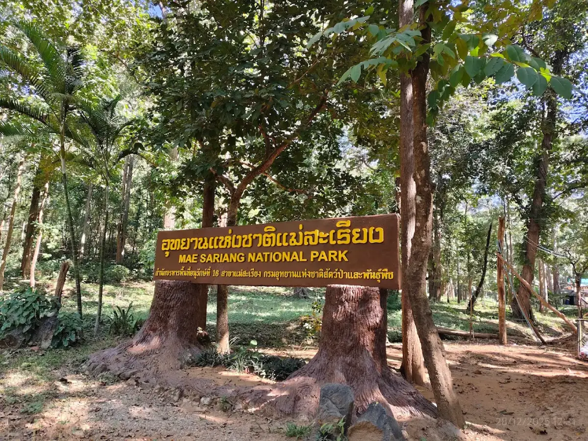
Mae Sariang National Park
Open Days: Daily for the office and general visitor service area. Access to forests and developing viewpoints is subject to permission from park authorities.
Opening Hours: 08:30–16:30 for general visitor services.
Mae Sariang National Park, Mae Hong Son Province, Thailand, is a conservation area in Mae Sariang District characterized by complex mountain ranges, upland forests, deep valleys, and landscapes connected with the Yuam River basin. The area is currently administered as Mae Sariang National Park (Under Establishment) by Thailand's Department of National Parks, Wildlife and Plant Conservation. Its responsibilities include forest protection, natural resource management, wildfire prevention, and the assessment of opportunities for environmentally appropriate nature tourism.
Mae Sariang is distinguished by its peaceful mountain environment and its character as a relatively small town surrounded by extensive highlands. Mountain ridges stretch across the landscape, separated by valleys containing settlements and transportation routes. Many local communities are situated along rivers and accessible lowlands, while the higher forested slopes remain important for watershed protection and ecosystem conservation. Traveling through the district reveals the close relationship between nature and everyday life in a remote mountain region.
One of the most significant natural features associated with the proposed national park is Doi Lak Saen, a mountain rising approximately 1,139 meters above sea level in Mae Ho Subdistrict, Mae Sariang District. The mountain provides panoramic views of the surrounding valleys and the Mae Sariang town area. During the cooler season, suitable atmospheric conditions can produce an extensive sea of mist over the lower landscape. These qualities have made Doi Lak Saen a focus of official surveys assessing its potential development as a nature tourism destination.
The area's importance extends beyond its elevated viewpoints. Continuous forests, variations in mountain elevation, and natural streams contribute to a diverse landscape with important ecological functions. These features are characteristic of Mae Hong Son Province and illustrate why conserving mountain forests matters both for biodiversity and for the communities that depend on downstream water resources.
History of Mae Sariang National Park is connected with the designation of protected forest areas and the preparation of management arrangements that recognize both natural resources and surrounding communities. The area is administered as a proposed national park undergoing the formal establishment process. This involves resource surveys, conservation assessments, and the development of measures to maintain forest environments over the long term.
On July 7, 2022, a public consultation meeting was held concerning the management plan for Mae Sariang National Park (Under Establishment) at Protected Areas Regional Office 16, Mae Sariang Branch. The consultation related to the management plan for 2023–2027. Such procedures are important because protected-area management must consider ecological information, existing land use, and the views of local communities and relevant government agencies.
Public consultation also demonstrates that establishing a protected area is closely connected with the lives of local residents. Forests in Mae Sariang are not isolated green spaces separated from surrounding settlements. They contribute to rainfall collection, stream systems, and environmental conditions in mountain valleys. Appropriate management therefore seeks to protect natural resources while taking account of the communities living around the conservation landscape.
During the establishment process, Mae Sariang National Park has continued to carry out forest patrols, prevent offenses involving natural resources, and monitor wildfire risks. These duties are particularly important during the dry season, when mountain forests in Mae Hong Son can contain substantial quantities of dry leaves and other flammable natural material. Conservation work in this terrain requires personnel familiar with steep slopes and difficult forest access.
In February 2026, Mae Sariang National Park personnel took part in efforts to investigate and control a wildfire near Ban Pa Kluai in the Mae Sariang area. The incident illustrated the challenges of working in mountainous terrain with steep slopes and limited access. Fire suppression required careful attention to ranger safety and continuing monitoring to prevent flames from spreading into surrounding forests.
Official Administrative Status remains Mae Sariang National Park (Under Establishment). This designation identifies an area undergoing the national park establishment process rather than a park already fully designated by Royal Decree. Management is conducted through Thailand's Department of National Parks, Wildlife and Plant Conservation and the conservation administration responsible for the Mae Sariang region.
The Name Mae Sariang is associated with Mae Sariang District, an important community and transportation center in southern Mae Hong Son Province. The name connects the conservation area with its surrounding geography and settlements. Mae Sariang town occupies a mountain valley where the Yuam River forms an important part of the landscape. The district also serves as a transportation connection between Mae Hong Son, Chiang Mai, and western border areas.
Mae Sariang differs from larger urban centers because mountain ranges surround the town on several sides. Roads cross ridges and valleys, and journeys between communities or natural attractions can involve winding mountain routes. Actual road distances are therefore more meaningful than straight-line measurements. These conditions also explain why developing nature tourism in the area requires careful consideration of safety and access.
Geography of Mae Sariang National Park is characterized by mountainous terrain, ridgelines, valleys, and forested slopes typical of northwestern Thailand. Some highland areas are steep and difficult to reach, while lower elevations contain streams and settlements located along natural drainage routes. Differences in altitude influence temperature, humidity, and the distribution of vegetation across the landscape.
The mountain formations around Mae Sariang also help create conditions suitable for morning mist. When humid air cools in valleys, water vapor can condense into tiny droplets suspended above the lower terrain. Viewed from a higher ridge, these clouds of mist can resemble a broad white sea covering the valleys. The formation of the sea of mist depends on both geography and the weather conditions of each day.
Steep mountain slopes influence how rainfall moves through the landscape. Some water infiltrates the soil and organic layers covering the forest floor, while the remainder travels through natural channels and streams before joining larger watercourses. These drainage systems are essential to the ecological balance of the area and contribute to water resources used by downstream communities.
Doi Lak Saen is one of the most significant mountain areas examined for tourism potential within the proposed national park. Located in Mae Ho Subdistrict, it rises approximately 1,139 meters above sea level and has been identified as the highest summit within the proposed Mae Sariang National Park area.
On December 24, 2021, national park personnel surveyed Doi Lak Saen to evaluate its possible development as a nature tourism attraction. The assessment considered terrain, scenic potential, and visitor carrying capacity. The purpose was to examine whether recreational use could be managed without placing excessive pressure on the natural environment.
According to the Department of National Parks' survey, Doi Lak Saen lies approximately 2 kilometers from Ban Huai Pu in Mae Ho Subdistrict. Its elevated terrain offers expansive views toward Mae Sariang and the surrounding mountain ranges. In winter, favorable conditions may produce a sea of mist over the valley below. From the summit area, the complex geography of Mae Sariang becomes particularly apparent.
The most distinctive feature of Doi Lak Saen is the broad panorama over Mae Sariang's valleys and settlements. When mist accumulates at lower elevations, some ridges emerge above the cloud layer. Early sunlight gradually changes the appearance of the scene, while clear days reveal the forested mountains extending into the distance. These contrasting conditions give the mountain considerable scenic value.
The assessment of Doi Lak Saen has involved more than its scenic appearance. Developing a viewpoint also requires consideration of access routes, rest areas, visitor safety, and possible environmental impacts. Mountain destinations with steep terrain or long distances from settlements need appropriate access management to reduce accidents and prevent damage caused by unauthorized trails.
The Sea of Mist in Mae Sariang is a natural phenomenon created by the interaction of cool air, humidity, and valleys. It is particularly associated with early mornings following cool nights when winds are relatively calm. Water vapor condenses into suspended droplets that gather over lower terrain. From a viewpoint above the cloud layer, this appears as mist extending across the valleys.
Mist does not develop in the same way every morning. On some days, dense clouds fill the valleys; on others, thin fog follows rivers and streams. Clear weather can reveal distant mountains without cloud cover. These variations result from changes in temperature, humidity, wind, and regional weather patterns. Every visit can therefore provide a different experience of the landscape.
Forests and Ecosystems of Mae Sariang are closely associated with the district's mountainous geography and seasonal climate. Highland forests retain moisture and provide habitats for many organisms. Variations in elevation and soil conditions contribute to different forms of vegetation. Forests receiving higher moisture differ in structure and composition from those experiencing more pronounced dry-season conditions.
Deciduous woodland undergoes visible changes between wet and dry seasons. During periods of regular rainfall, trees carry green foliage and the forest floor remains relatively moist. In the dry season, some species shed their leaves to reduce water loss. Fallen leaves gradually decompose into organic matter, although dry plant material can also increase wildfire risks during the hottest months.
Forests with dense canopies can maintain different ground conditions from exposed ridgelines. Shade reduces evaporation, while tree roots help stabilize soil on steep slopes. These processes make forests important components of the natural water system and contribute to limiting erosion during intense rainfall.
Watershed Conservation is central to protecting the mountains around Mae Sariang. When upland forests remain healthy, rainfall can infiltrate the soil and move through natural drainage systems. Trees and ground vegetation slow runoff and help prevent the rapid removal of soil. These functions contribute to maintaining water quality in streams flowing toward lower settlements.
Deforestation on steep slopes can reduce the ability of root systems to stabilize the ground. During heavy rain, surface runoff may become faster and carry more sediment into streams. Conserving watershed forests is therefore important for reducing erosion risks and maintaining the environmental condition of downstream watercourses.
The Yuam River and Mae Sariang's Landscape form an important part of the geographical setting surrounding the proposed national park. The Yuam River passes through Mae Sariang District and is closely associated with settlement patterns in the valleys. Riverside areas have long been significant to local livelihoods and the use of freshwater resources. The relationship between mountains, forests, and the Yuam River helps explain the wider geography of Mae Sariang.
The Yuam River belongs to a wider freshwater system in northwestern Thailand. Water from mountain streams flows along natural gradients before joining larger rivers. Communities situated near the water depend on the environmental condition of upstream landscapes. Forest conservation therefore affects not only the mountains themselves but also the quality and stability of downstream environments.
Wildlife and Biodiversity are important components of the mountain ecosystem. Different animals contribute to ecological processes through feeding, predation, seed dispersal, and nutrient cycling. Smaller organisms living in forest soil participate in the decomposition of organic material, while birds and mammals depend on forest habitats for food and shelter.
Wildlife sightings during a visit depend on the species, time of day, and degree of human disturbance. Quiet forest habitats with suitable food resources support natural animal behavior more effectively than constantly disturbed areas. Visitors should maintain a safe distance, never feed wild animals, and avoid disturbing their habitats.
Wildfire Prevention in Mae Sariang is an important responsibility of conservation personnel. Mae Hong Son contains extensive mountains and experiences dry conditions during part of the year. When leaves and other natural material become dry, a small ignition source can lead to rapidly spreading fires, especially on steep slopes where terrain and wind influence the movement of flames.
Wildfires affect far more than the trees that burn. They can harm wildlife, forest soil organisms, air quality, and the ecological condition of surrounding areas. Fires in remote highland locations can be particularly difficult to control. Forest personnel must balance the need for rapid intervention with the safety of those working in difficult terrain.
Firefighting operations near Ban Pa Kluai in February 2026 demonstrated the challenges posed by cliffs and steep mountain slopes. Some locations were difficult to reach on foot, requiring continued monitoring to prevent the spread of fire. The incident illustrates why preventing ignition is often more effective than attempting to control a large wildfire after it has developed.
Winter in Mae Sariang brings cooler conditions to the mountains, particularly at night and in the early morning. Lower temperatures combined with suitable valley humidity can produce morning mist. The highlands often feel peaceful, and clear skies reveal successive mountain ridges stretching across the landscape.
The beauty of the winter landscape results from several elements acting together: the gradual changes in early sunlight, the layered appearance of mountain ridges, and atmospheric moisture that creates thin fog or a broad sea of mist. These conditions differ from those of summer and the rainy season, giving the mountains of Mae Hong Son a distinctive atmosphere during cooler months.
The Rainy Season in Mae Sariang is characterized by lush forest vegetation and higher stream levels. Rainfall provides moisture for mountain plants and increases humidity in the valleys. Clouds can remain around the ridges for extended periods, producing a fresh, green landscape that clearly reveals the natural water cycle.
Mountain environments during the rainy season also present risks from slippery ground, flash floods, and damaged trails. Routes crossing slopes or natural drainage channels require particular care. Forest access should comply with official safety arrangements, and temporary trail closures may be necessary to protect visitors and prevent environmental damage.
Summer and Seasonal Forest Changes bring drier conditions to parts of the landscape. Some trees lose their leaves, and dry plant material accumulates on the forest floor. Daytime temperatures can be high, while smoke and airborne particles from regional wildfires may reduce visibility across the mountains. Conservation activities during this season emphasize fire prevention and restrictions on activities that could increase ignition risks.
Getting to Mae Sariang National Park begins with reaching Mae Sariang District in Mae Hong Son Province. The park's office and contact area are associated with Ban Kat Subdistrict. From Chiang Mai Province, the main route follows Highway 108 through Hot District before continuing toward Mae Sariang.
Highway 108 passes through mountainous terrain and includes winding sections. Drivers should consider weather, road visibility, and vehicle condition, especially during rain or dense fog. Traveling in daylight generally makes it easier to see curves and changes in road conditions. A private vehicle also provides greater flexibility for connecting several destinations within the district.
From Mae Sariang, travelers can continue northward toward other parts of Mae Hong Son Province or travel south toward Sop Moei and the border region along authorized roads. Mae Sariang consequently serves as an important stop for visitors traveling through northern Thailand and those interested in less urbanized areas of Mae Hong Son.
Access to Doi Lak Saen differs from visiting the park office because the mountain has been surveyed as a potential future tourism site. Entry remains subject to park management and relevant forest access rules. It should not be treated as an independently accessible attraction with the same established visitor facilities as a fully developed national park viewpoint.
A scenic mountain destination may still have limitations involving access roads, parking, communications, and emergency assistance. Developing safe tourism requires consideration of these practical requirements and the capacity to manage visitors. Following official access arrangements helps protect forest resources while reducing risks to travelers.
The Park's Relationship with Local Communities concerns the connections between watershed forests, mountains, and settlements in the valleys. Mae Sariang residents live in environments shaped by topography and freshwater resources. Healthy forests contribute to water retention, reduced soil erosion, and suitable ecological conditions for many species, all of which are relevant to the wider landscape inhabited by local communities.
Nature tourism also connects with local economic activities. Visitors traveling through Mae Sariang need restaurants, accommodation, and transportation services. The town offers a variety of these facilities along its main roads and within residential areas, making it a convenient base for exploring cultural sites and planning authorized visits to natural areas.
Nearby Attractions in Mae Sariang District include temples, historical sites, and scenery along the Yuam River. Wat Phra That Chom Mon, Wat Phra That Chom Thong, and Wat Phra That Chom Chaeng are associated with local Buddhist beliefs and religious heritage. The older parts of Mae Sariang town and the riverside communities provide additional opportunities to experience local life and the town's landscape.
Wat Phra That Chom Mon is an important religious destination in Mae Sariang. Its hilltop setting connects the temple with the surrounding landscape, while the sacred stupa forms a focus of worship and community faith. Visiting the temple provides an opportunity to learn about the relationship between Buddhism, local communities, and cultural heritage in Mae Sariang.
Wat Phra That Chom Thong and Wat Phra That Chom Chaeng are other important stops on the district's Buddhist heritage route. These temples reflect enduring relationships between local communities and religious traditions. Visitors should dress respectfully, observe proper conduct, and avoid disturbing religious activities to preserve the peaceful atmosphere of these places.
Wat Kittiwong and Wat Si Bun Rueang are also associated with the historical and cultural life of Mae Sariang. Buddhist temples serve as places of worship and community gathering and reflect aspects of local architecture and tradition. Visiting these temples adds cultural depth to a journey centered on the district's natural landscapes.
The Yuam River Scenic Route offers another way to experience the area. The river passes through a landscape shaped by mountains and nearby communities. Accessible riverside viewpoints allow travelers to appreciate how the town and its natural surroundings exist alongside one another, particularly in the morning or late afternoon when the light is softer.
Mae Sariang is also a gateway to Salawin National Park, another important protected area in Mae Hong Son Province. Salawin National Park is characterized by the Salawin River and border landscapes. Its geography and access arrangements differ from those of Mae Sariang National Park, making it a separate destination that can be included in a wider journey when travel time allows.
The Difference Between Mae Sariang National Park and Salawin National Park concerns both legal status and natural features. Salawin is an officially established national park with river and border scenery as important attractions. Mae Sariang remains under establishment and is associated with upland forests and mountain terrain, including Doi Lak Saen, where tourism potential has been studied. Understanding this distinction is important when interpreting access arrangements and visitor regulations.
Nature and Culture in Mae Sariang are closely connected. The town occupies a landscape of mountains, rivers, and established communities. Combining nature observation with visits to religious and cultural sites offers insight into several aspects of the region, including forest protection, the use of freshwater resources, and the continuing role of Buddhism in local society.
Accommodation in Mae Sariang District includes hotels, resorts, and guesthouses in the town. Properties around Langpanich Road and the Yuam River area are convenient for travelers wishing to reach restaurants and cultural attractions. Staying in town also makes it easier to coordinate onward travel to natural areas where permission or ranger assistance is required.
Travelers interested in the riverside atmosphere can choose accommodation overlooking the Yuam River or surrounding mountains, while hotels in the central district provide access to shops and transportation services. This range of accommodation makes Mae Sariang a useful base for exploring southern Mae Hong Son Province.
Restaurants and Local Food in Mae Sariang range from Thai and regional cuisine to establishments serving travelers from different backgrounds. Many are located along Langpanich Road and within the town. Some occupy traditional wooden buildings associated with the area's commercial history, allowing a meal to become part of the experience of exploring Mae Sariang's cultural landscape.
Coriander in Redwood is one example of a restaurant housed in a historic timber building on Langpanich Road. The building is associated with Mae Sariang's former teak-trading economy and transport along the Yuam River. Its preserved wooden character and contemporary restaurant use offer a connection with the town's commercial past.
Safety in Mountain Tourism is especially important when visiting Mae Sariang because certain routes cross steep terrain far from settlements. Weather can change rapidly in the highlands. The rainy season can bring slippery ground and flash floods, while winter nights may be considerably colder than the valleys. Entering forest areas should therefore follow appropriate permission and safety arrangements.
Vehicles used on mountain roads should be mechanically sound, with brakes and tires suitable for winding routes. Drivers should reduce speed and increase following distances during rain or fog. Journeys into areas with limited communications also require attention to travel planning and the ability to request assistance in an emergency.
Rules for Visiting Protected Areas include keeping natural environments clean, avoiding the removal of natural resources, and never feeding wildlife. Visitors should use authorized routes and refrain from creating new trails or damaging vegetation. Lighting fires or carrying out activities that increase wildfire risks must be avoided, especially during the dry season.
Maintaining a quiet atmosphere is part of responsible nature tourism. Loud noise and close approaches can disturb wildlife behavior. Observation should therefore take place from a safe distance, without chasing animals or entering sensitive habitats. Respecting these principles helps maintain the ecological value of protected forests.
The Importance of Mae Sariang National Park to Mae Hong Son Province lies in its role as a conservation landscape connecting mountains, forests, rivers, and local communities. Forest protection and wildfire prevention help maintain environmental conditions throughout the district. Doi Lak Saen demonstrates the area's significant scenic potential, while its development as a tourist destination requires appropriate access management and ecological safeguards.
Mae Sariang National Park also illustrates that conservation is an ongoing process involving government agencies and local communities. Protecting forests, managing watersheds, and determining suitable tourism activities require reliable information and arrangements adapted to the mountainous terrain. These efforts aim to preserve natural resources while maintaining a constructive relationship between communities and the surrounding environment.
Mae Sariang National Park in Mae Hong Son Province is therefore important for much more than mountain scenery or the possibility of seeing a sea of mist. Its forests support ecological processes and natural water resources in the Mae Sariang region. Doi Lak Saen illustrates the scenic potential of the uplands, while Mae Sariang town, the Yuam River, and nearby temples reveal the broader connections between nature, culture, and local life in northwestern Thailand.
| Place Name | Mae Sariang National Park (Under Establishment), Mae Hong Son Province, Thailand |
| Office Location | Moo 6, Ban Kat Subdistrict, Mae Sariang District, Mae Hong Son Province 58110, Thailand |
| Office Location Reference | 6WPW+8CQ, Mae Sariang District, Mae Hong Son Province |
| Legal Status | National Park Under Establishment |
| Managing Authority | Department of National Parks, Wildlife and Plant Conservation; Protected Areas Regional Office 16, Mae Sariang Branch |
| Open Days | Daily for General Visitor Services |
| Opening Hours | 08:30–16:30 for General Visitor Services |
| General Admission Fee | Free Admission to the General Visitor Service Area |
| Regional Office Contact | +66 53 681 330, Protected Areas Regional Office 16, Mae Sariang Branch |
| Managing Office Website | https://dnp16mr.com/ |
| Management Plan | 2023–2027 Management Plan, Subject to Public Consultation in 2022 |
| Landscape | Mountain Ranges, Ridges, Valleys, Forests and Upland Watersheds in Mae Sariang District |
| Significant Natural Feature | Doi Lak Saen, Mae Ho Subdistrict, Mae Sariang District |
| Doi Lak Saen Elevation | Approximately 1,139 Meters Above Mean Sea Level |
| Doi Lak Saen Distance | Approximately 2 km from Ban Huai Pu, Mae Ho Subdistrict, According to the Official Survey |
| Doi Lak Saen Visitor Status | Potential Nature Viewpoint Under Tourism Development Assessment; Access Subject to Park Permission |
| Related Activities | Environmental Education, Mountain Landscape Observation, Forest Ecosystem Studies and Authorized Visits to Scenic Areas |
| Seasons | Cool Season for Mountain Scenery and Possible Sea of Mist; Rainy Season for Lush Forests, Subject to Access Restrictions |
| Getting There from Chiang Mai | Follow Highway 108 through Hot District toward Mae Sariang, Mae Hong Son Province |
| In-Area and Nearby Attractions | 1. Doi Lak Saen – Approximately 2 km from Ban Huai Pu; Potential Tourism Area 2. Wat Phra That Chom Mon – Mae Sariang District 3. Wat Phra That Chom Thong – Mae Sariang District 4. Wat Phra That Chom Chaeng – Mae Sariang District 5. Wat Kittiwong – Mae Sariang Town 6. Wat Si Bun Rueang – Mae Sariang Town 7. Yuam River Scenery – Mae Sariang Town 8. Salawin National Park – Separate Protected Area in Mae Sariang and Sop Moei Districts |
| Restaurants and Cafés in Mae Sariang | 1. Coriander in Redwood – Langpanich Road, Tel. +66 53 683 309 2. Pa Ka Yor's Pub and Restaurant – Langpanich Road, Tel. +66 53 683 066 3. Sawadee Cafe & Bar – Langpanich Road, Tel. +66 95 234 5508 4. Screw & Brew – Langpanich Road, Tel. +66 53 682 323 5. Chom Bakery – Mae Sariang Road, Tel. +66 82 195 4475 |
| Accommodation in Mae Sariang | 1. Riverhouse Resort – Langpanich Road, Tel. +66 53 683 066, +66 53 683 068 2. Riverhouse The Teak House – Langpanich Road, Tel. +66 53 682 323 3. Mitaree Hotel 1 – Mae Sariang Town, Tel. +66 53 681 110 4. Chok Wasana Guesthouse – Langpanich Road, Tel. +66 95 591 6282 5. Mae Sariang Home – Ban Kat Subdistrict, Tel. +66 94 497 8956 6. Above The Sea Maesariang – Mae Sariang Town |
Frequently Asked Questions (FAQ)
Q: Where is Mae Sariang National Park located?
A: Mae Sariang National Park is located in Mae Sariang District, Mae Hong Son Province, Thailand. Its office is associated with Moo 6, Ban Kat Subdistrict, while Doi Lak Saen is a significant mountain area in Mae Ho Subdistrict.
Q: Is Mae Sariang National Park open to visitors?
A: The office and general visitor service area are listed as operating daily from 08:30 to 16:30. Forest access and viewpoints undergoing development remain subject to permission and park regulations.
Q: How much is the entrance fee?
A: General visitor services are currently listed as free of charge. Activities or restricted areas may be subject to separate arrangements established by the responsible authority.
Q: Has Mae Sariang National Park been officially established?
A: The official administrative designation remains Mae Sariang National Park (Under Establishment). Conservation activities and park management planning continue as part of the establishment process.
Q: How high is Doi Lak Saen?
A: Doi Lak Saen rises approximately 1,139 meters above sea level and is located about 2 kilometers from Ban Huai Pu in Mae Ho Subdistrict. The mountain has been surveyed by the Department of National Parks for its tourism potential.
Q: What makes Doi Lak Saen special?
A: Doi Lak Saen provides broad views over the Mae Sariang area and surrounding mountain ranges. During the cooler season, suitable conditions can produce a sea of mist over the valleys.
Q: How do travelers reach Mae Sariang from Chiang Mai?
A: Follow Highway 108 through Hot District toward Mae Sariang in Mae Hong Son Province. The route includes mountain roads and winding sections that require careful driving.
Q: What attractions can be visited around Mae Sariang?
A: Nearby cultural attractions include Wat Phra That Chom Mon, Wat Phra That Chom Thong, Wat Phra That Chom Chaeng, Wat Kittiwong, and Wat Si Bun Rueang. The Yuam River provides local scenery, while Salawin National Park is a separate protected area that can be included in a wider itinerary.
 Category: ●Nature and Wildlife
 Group: ●National Parks and Marine Reserves
Last Update : 2 WeekAgo
 Last Update : 2 WeekAgo
 Click to Access the Navigation Map GPS
Mae Sariang National Park Map
Recommend

 Art, Culture and Heritage
 Historical Sites and Monuments(1)
 Landmarks and Memorials(1)
 Art, Craft Centres, Tradition(10)
 Museums(3)
 Educational Places
 Educational Gardens, Farm(1)
 Places of Worship
 Temple(81)
 Other Sacred Sites(3)
 Research and Development
 Royal Project(4)
 Suburban Living
 Village, Community(19)
 Local Market(4)
National Parks and Marine Reserves(7)
 Mountain (Doi)(5)
 Dam, Reservoir, Lake(2)
 Waterfalls(12)
 Hot Springs(6)
 Caves(13)
 Flower Field(2)
 River, Canal(3)
 Other natural attractions(1)
 Entertainment and Agricultural
 Farms, Parks and Ecotourism(2)
 Shopping
 Shopping and Night Market(1)
 Travel Articles, Recipes
 Travel Review, Food Review(2)


