
lovethailand home >South Travel Attractions >Songkhla Travel Attractions >Saba Yoi >Ba Hoi > San Kala Khiri National Park
TL;DR: San Kala Khiri National Park is located at Moo 2, Ban Rai Nuea, Tambon Bahoi, Saba Yoi District, Songkhla Province, open Daily, hours 08.00 – 17.00.

San Kala Khiri National Park
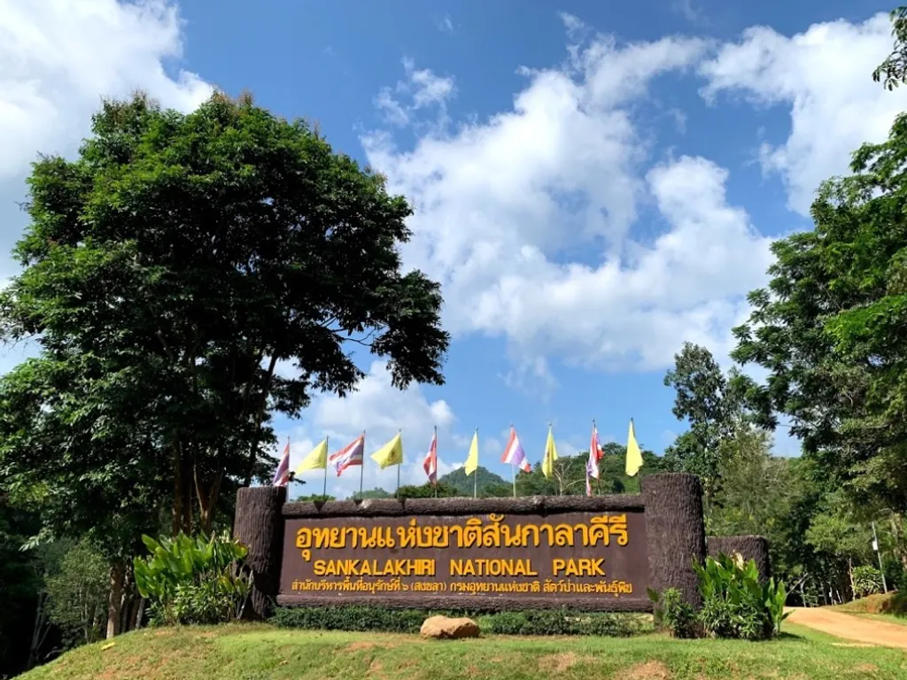
Open Days: Daily
Opening Hours: 08.00 – 17.00
San Kala Khiri National Park in Songkhla Province is a nature and historical destination in Saba Yoi District, set within the Sankalakhiri mountain range along the Thai–Malaysian border. The area is known for its humid evergreen forest, watershed landscape, limestone caves, nature trails, Ban Si Hui, Tham Kraduk, Tham Phueng, Tham Talot, Bang Thepha, and the headwater forest of the Thepha River. It is a suitable destination for travelers who want to experience Songkhla beyond beaches and old-town attractions, with a focus on forest ecology, borderland geography, and local history.
The park is located in Tambon Bahoi, Saba Yoi District, Songkhla Province. Its landscape is defined by complex mountain terrain, dense tropical forest, streams, caves, and valley routes that connect natural and historical sites. The Sankalakhiri range forms an important natural border between Thailand and Malaysia, and the forest in this area is part of a wider ecological corridor that supports biodiversity in the lower southern region of Thailand.
San Kala Khiri National Park is especially important as a watershed forest for the Thepha River, one of Songkhla’s significant waterways. The forest helps regulate water flow, protect soil, sustain stream systems, and support communities downstream. A visit to this park is therefore not only a nature trip but also a way to understand how mountain forest, water, wildlife, and local livelihoods are connected in southern Thailand.
The area has long been recognized for its ecological importance. Surveys of the Sankalakhiri forest and surrounding reserved forest areas found that the landscape remained rich in natural resources and suitable for conservation. Local communities in Ban Rai Nuea and Tambon Bahoi also played a role in supporting protection of the forest. The development of the area as a national park framework has helped safeguard its watershed forest, wildlife habitats, and nature-based tourism value.
The forest is mainly humid evergreen forest, with dense canopy layers, vines, undergrowth, ferns, mosses, and large trees. This forest type creates a cool, shaded, and moist atmosphere along the trails. Visitors can experience flowing streams, rocky channels, birdsong, and the quiet character of southern borderland forest. Unlike coastal Songkhla, San Kala Khiri offers a deeply inland experience shaped by mountains, water, caves, and forest paths.
The wildlife of the Sankalakhiri forest reflects the ecological quality of the area. Mammals, birds, reptiles, insects, and rare wildlife have been recorded in the wider forest landscape. Recent official wildlife operations in Saba Yoi also show that elephants use parts of the conservation landscape. Visitors should treat the area as a real wildlife habitat. Do not feed animals, approach wildlife, make loud noise, or leave marked paths. Park staff instructions should always be followed.
Ban Si Hui is one of the most important historical sites in the park. It was once a large settlement more than 100 years ago, located on a broad plain surrounded by mountains and streams. The original residents were Thai people who had lived in Kedah, now part of Malaysia, before moving to search for a new settlement area. They found several flat areas near the Thai–Malaysian border around boundary markers 39–40, including areas associated with Ban Mara Nuea and Ban Mara Tai. Ban Si Hui therefore carries the history of migration, settlement, and borderland life.
The story of Ban Si Hui is both fascinating and poignant. The forest settlement eventually collapsed because of disease, leaving behind traces of memory rather than a living village. Visiting Ban Si Hui is not just a walk through the forest. It is a journey through a place where people once lived, worked, built homes, and formed a community deep in the mountains. For travelers interested in local history, Ban Si Hui adds a human dimension to the natural landscape of San Kala Khiri.
Tham Kraduk, or Bone Cave, is about 1 kilometer from Ban Si Hui. Inside the cave is a broad chamber that can hold around 50 people. The cave is historically significant because it was once used to keep the bones of people from that period. Visitors should approach the cave with respect. Tham Kraduk is not only a natural cave but also a memory site connected with illness, loss, and the end of an old forest community.
Tham Phueng, or Honey Cave, is a limestone cave with natural beauty and a shaded forest setting. The cave is known for its cliff overhangs where bees build many nests in season. The surrounding landscape is quiet and green, making it a rewarding stop for travelers interested in caves, limestone formations, and forest ecology. Visitors should avoid disturbing bees, touching cave formations, or making loud noise inside the cave environment.
Tham Talot is located around Ban Tham Talot, where Wat Tham Talot is also situated. The area consists of a large limestone mountain formation surrounding a shaded interior landscape with many trees and several caves. Some caves in this area can be walked through, and the interiors contain stalactites and stalagmites. This makes Tham Talot suitable for travelers interested in geology, limestone landscapes, and community-based travel in Saba Yoi.
The Thepha River is one of Songkhla’s important rivers, and its headwaters are found in the forest of San Kala Khiri. To reach the river source area, travelers continue from the park office toward Ban Bahoi and then walk through dense forest for about 1 kilometer. The riverbanks are lined with large trees and shaded forest. The route from Ban Tham Talot to Ban Bahoi passes through hillsides covered with dense tropical forest, making it suitable for travelers who are physically prepared for a more serious nature walk.
Bang Thepha is another important natural point in the park. It is formed where two streams, Khlong Lam Lot and Khlong Thepha, meet and deposit sand and sediment into a wide open area. This creates a sandbar-like landscape within the forest. Bang Thepha is useful for understanding how flowing water shapes the land over time, and it is also a natural resting point along the nature route.
The park’s nature trail allows visitors to experience the forest more closely. The route from the park office area around Bang Thepha to Ban Si Hui is about 4 kilometers and takes about 2 hours on foot. Along the way, travelers pass streams, valleys, rock channels, shaded forest, and historical traces. This route combines ecology and history in one walk, making it one of the most meaningful experiences in San Kala Khiri.
From Ban Si Hui, visitors can continue about 1 kilometer to Tham Kraduk and Tham Phueng. The route is shaded by trees and filled with forest sounds, birdsong, and the presence of bats living in the caves. This section gives travelers a strong sense of how forest, caves, water, wildlife, and human history exist together in the same landscape.
Preparation is important when walking in San Kala Khiri. Although some routes are not very long, the humid evergreen forest can be slippery, wet, and physically demanding in places. Visitors should wear shoes with good grip, bring drinking water, carry light rain protection, and protect phones or cameras from moisture. It is best to inform park staff before walking deeper trails, especially during the rainy season or when the weather changes quickly.
The best time to visit San Kala Khiri is on a day when rain is not heavy and the trails are safe. Southern Thailand can experience rain in many months of the year, so forest and stream travel should always be planned around weather conditions. During periods of continuous rain, water levels may rise quickly, rocks can become slippery, and some routes may not be suitable for visitors. Travelers should check local announcements and choose activities that match the day’s conditions.
A half-day visit is suitable for travelers who want to relax near the park office, enjoy the forest atmosphere, and walk a short nature route. A full-day visit is better for those who want to walk from Bang Thepha to Ban Si Hui, continue to Tham Kraduk and Tham Phueng, and include Tham Talot or the Thepha River area if time and conditions allow. San Kala Khiri is best experienced slowly because its value lies in atmosphere, forest details, and the relationship between nature and history.
For photography, San Kala Khiri offers park entrance scenes, dense forest, streams, limestone caves, rock channels, village routes, and borderland landscapes. Morning is suitable for soft light and forest atmosphere, while the afternoon is better for shaded areas. Inside caves, visitors should use light carefully, avoid disturbing bats, and never touch stalactites or stalagmites directly.
San Kala Khiri National Park suits many types of travelers. Families can use it as a place for children to learn about forests, rivers, and caves. Students can study watershed ecology, limestone cave systems, and borderland settlement history. Nature travelers can enjoy a quiet forest experience away from crowded tourist routes, while cultural travelers can better understand the story of Ban Si Hui and old communities in the forest.
Compared with Songkhla’s more familiar attractions, San Kala Khiri has a clear inland identity. Samila Beach and Songkhla Old Town represent the sea, city culture, and coastal heritage. San Kala Khiri represents mountain forest, river sources, caves, wildlife, and borderland history. Adding this park to a Songkhla itinerary gives travelers a more complete view of the province, beyond beaches and urban landmarks.
Getting There is best by private car or rental car. From the Songkhla–Pattani route, take Highway 43, turn onto Highway 4085 through Thepha District toward Saba Yoi, then continue from Saba Yoi on Highway 4095 through Ban Khao Daeng to Ban Tham Talot. From Ban Tham Talot, turn left and continue for about 10 kilometers to reach the park office. This route is more convenient by self-drive transport because public access to the park area is limited.
Drivers should check the vehicle, fill fuel before entering rural routes, and prepare offline navigation where possible. Mobile signal may be inconsistent in some forest or borderland areas. During rain, drive slowly and avoid unknown side roads. For deeper forest routes, caves, or stream areas, visitors should ask park staff before beginning the trip.
Useful items for visiting San Kala Khiri include shoes with good grip, breathable clothing, a hat, drinking water, personal medicine, insect protection, a small flashlight, and waterproof protection for phones or cameras. Visitors should not begin long trail walks late in the day. Cave and forest areas are not suitable for solo walking, so traveling in a group and informing staff of the intended route is recommended.
Responsible travel is essential at San Kala Khiri because the area is a protected forest, a watershed, a wildlife habitat, and a historical landscape. Visitors should not litter, write on cave walls, collect plants or rocks, disturb animals, make loud noise, or leave marked routes. Respectful travel helps protect the park’s natural and historical value for future visitors.
Overall, San Kala Khiri National Park is one of Songkhla’s most meaningful inland destinations. It combines humid evergreen forest, border mountains, the Thepha River headwaters, limestone caves, nature trails, Ban Si Hui, and the memory of an old forest community. With proper preparation, safe timing, and respect for nature, San Kala Khiri offers a travel experience that connects forest, water, wildlife, people, and southern borderland history in a way few places in Songkhla can match.
| Name | San Kala Khiri National Park |
| Location | Moo 2, Ban Rai Nuea, Tambon Bahoi, Saba Yoi District, Songkhla Province |
| Address | Ban Rai Nuea, Tambon Bahoi, Saba Yoi District, Songkhla Province 90210, Thailand |
| Coordinates | 6.326626, 100.9209291 |
| Highlights | Thai–Malaysian border forest, Thepha River watershed, Ban Si Hui, Tham Kraduk, Tham Phueng, Tham Talot, Bang Thepha, and nature trails |
| History | The Sankalakhiri forest has been surveyed and promoted as a protected area because of its watershed value, rich ecosystem, and historical importance connected with old borderland communities. |
| Name Origin | The name comes from the Sankalakhiri mountain range, a complex mountain system along the Thai–Malaysian border. |
| Distinctive Features | Complex mountain terrain, humid evergreen forest, streams, limestone caves, wildlife habitats, and the watershed landscape of the Thepha River |
| Travel Information | Use Highway 43 on the Songkhla–Pattani route, turn onto Highway 4085 through Thepha District to Saba Yoi, then continue on Highway 4095 through Ban Khao Daeng to Ban Tham Talot. Turn left and drive about 10 km to the park office. |
| Current Status | Open as a nature attraction, watershed learning area, and conservation site in Saba Yoi District, Songkhla Province |
| Open Days | Daily |
| Opening Hours | 08.00 – 17.00 |
| Facilities | Camping ground, tents for visitors, staff contact point, and nature trails |
| Main Areas / Zones | Park office area, Bang Thepha, Ban Si Hui, Tham Kraduk, Tham Phueng, Tham Talot, and the Thepha River headwater area |
| Caretaker | San Kala Khiri National Park, Department of National Parks, Wildlife and Plant Conservation |
| Main Contact Number | 0 7431 1020 |
| Official Website / Official Page | Department of National Parks, Wildlife and Plant Conservation news website and San Kala Khiri National Park information channels |
| Nearby Tourist Attractions | 1. Bang Thepha, about 0 km 2. Ban Si Hui, about 4 km 3. Tham Kraduk, about 5 km 4. Tham Phueng, about 5 km 5. Tham Talot / Wat Tham Talot, about 10 km 6. Thepha River Headwater Area, about 18 km |
| Nearby Restaurants | 1. Isan Tam Saep, about 25 km, Tel. 095-759-8669 2. Kani Restaurant, about 25 km 3. Phi Mai Restaurant, about 30 km |
| Nearby Accommodations | 1. Ban Suan Tamon @ Bahoi, about 10 km, Tel. 084-727-7998 2. Chadawadee Resort, about 25 km, Tel. 087-081-3156, 087-285-3414, 081-093-7997 3. Sanae Mai Hom Resort, about 25 km, Tel. 086-285-1228 4. Baan Suan Resort Saba Yoi, about 25 km, Tel. 061-061-9973 5. Saba Yoi Country Resort, about 25 km, Tel. 093-787-3645 |
Frequently Asked Questions (FAQ)
Q: Where is San Kala Khiri National Park located?
A: San Kala Khiri National Park is located in Moo 2, Ban Rai Nuea, Tambon Bahoi, Saba Yoi District, Songkhla Province, along the Sankalakhiri mountain range near the Thai–Malaysian border.
Q: What are the main highlights of San Kala Khiri National Park?
A: The main highlights are humid evergreen forest, the Thepha River watershed, nature trails, Ban Si Hui, Tham Kraduk, Tham Phueng, Tham Talot, Bang Thepha, and the quiet borderland forest landscape.
Q: What time does San Kala Khiri National Park open?
A: The park is open daily from 08.00 to 17.00.
Q: Why is Ban Si Hui historically important?
A: Ban Si Hui was an old forest settlement more than 100 years ago, linked with Thai migrants from Kedah and the history of settlement near the Thai–Malaysian border.
Q: How far are Tham Kraduk and Tham Phueng from Ban Si Hui?
A: Tham Kraduk and Tham Phueng are about 1 km from Ban Si Hui. Both sites should be visited with care and respect because of their natural and historical significance.
Q: How long does the nature trail take?
A: The trail from Bang Thepha to Ban Si Hui is about 4 km and takes around 2 hours. Visitors can continue another 1 km to Tham Kraduk and Tham Phueng.
Q: How can travelers get to San Kala Khiri National Park?
A: Travelers can use Highway 43, connect to Highway 4085 through Thepha District to Saba Yoi, then take Highway 4095 through Ban Khao Daeng to Ban Tham Talot and turn left for about 10 km to the park office.
Q: What should visitors prepare before visiting San Kala Khiri National Park?
A: Visitors should bring shoes with good grip, drinking water, rain protection, insect repellent, personal medicine, a waterproof bag, and a flashlight. For deeper forest routes, ask park staff before starting.
Mobile : 074311020
 Mobile : 074311020
 Category: ●Nature and Wildlife
 Group: ●National Parks and Marine Reserves
Last Update : 2 MonthAgo
 Last Update : 2 MonthAgo
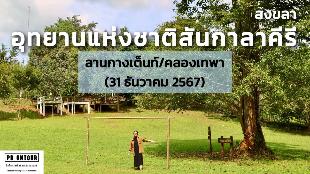
 Click to Access the Navigation Map GPS
San Kala Khiri National Park Map
Recommend

 Art, Culture and Heritage
 Historical Sites and Monuments(2)
 Landmarks and Memorials(7)
 Royal Palace(1)
 Art, Craft Centres, Tradition(4)
 Museums(4)
 Art Gallery(1)
 Educational Places
 Library(1)
 Educational Gardens, Farm(3)
 Places of Worship
 Temple(52)
 Mosque(2)
 Other Sacred Sites(11)
 Suburban Living
 Village, Community(3)
 Local Market(3)
 Floating Market(2)
National Parks and Marine Reserves(5)
 Mountain (Doi)(6)
 Dam, Reservoir, Lake(5)
 Waterfalls(12)
 Caves(4)
 River, Canal(2)
 Bays and Beaches(13)
 Islands(3)
 Other natural attractions(2)
 Entertainment and Agricultural
 Zoos and Aquariums(2)
 Animal camps and shows(1)
 Farms, Parks and Ecotourism(6)
 Waterpark(1)
 Travel Articles, Recipes
 Travel Review, Food Review(1)
 Southern Food Menu, Southern Food Recipes(2)


