
lovethailand home >South Travel Attractions >Nakhon Si Thammarat Travel Attractions >Nop Phi Tam >Krung Ching > Krung Ching Waterfall
TL;DR: Krung Ching Waterfall is located at Krung Ching Subdistrict, Nopphitam District, Nakhon Si Thammarat 80160, open Daily during the open season, except Khao Luang National Park’s annual closure, hours 08.30 – 16.30.
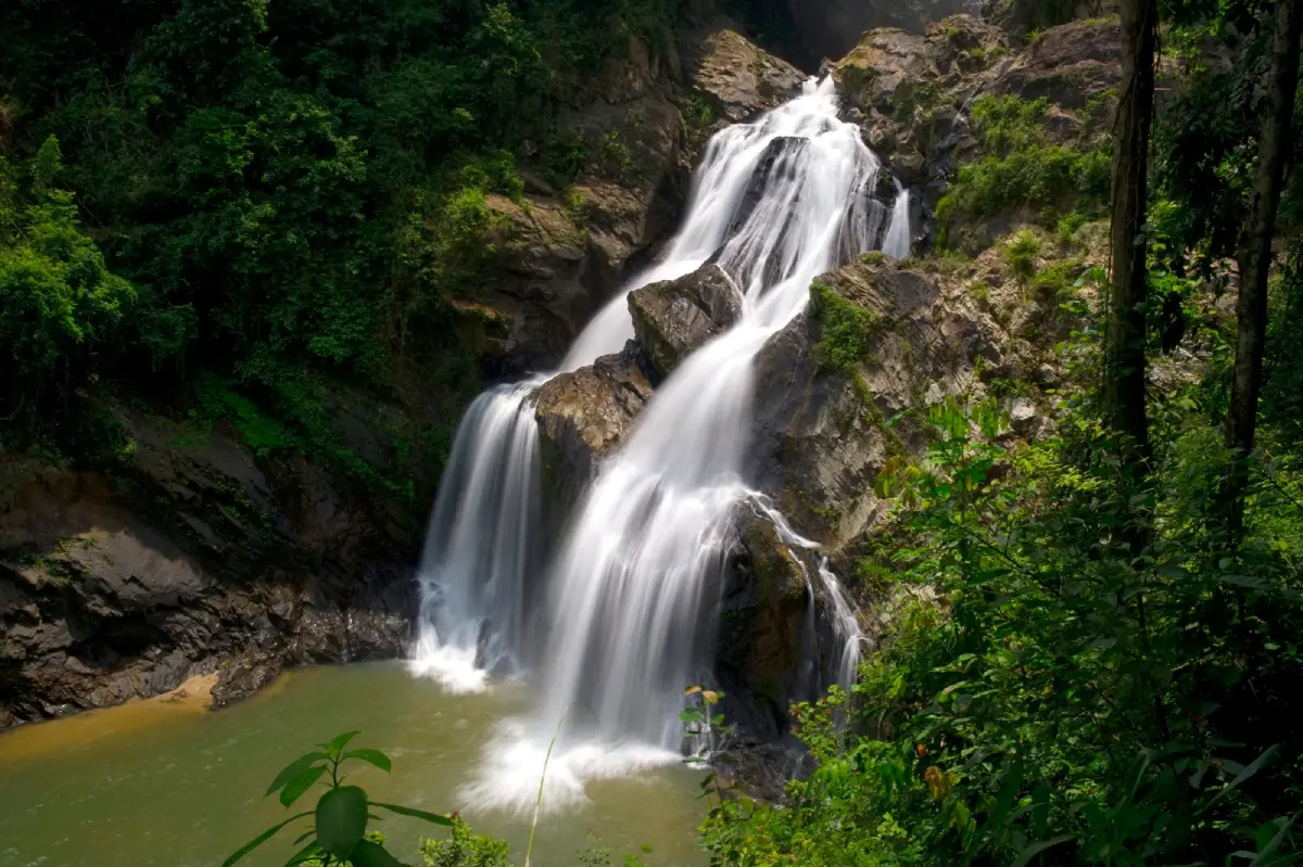
Krung Ching Waterfall
Open Days: Daily during the open season, except Khao Luang National Park’s annual closure from 1 October – 15 December
Opening Hours: 08.30 – 16.30
Krung Ching Waterfall in Nakhon Si Thammarat is one of the most important natural attractions in Khao Luang National Park. Located in Krung Ching Subdistrict, Nopphitam District, the waterfall is best known for its 3.7-km nature trail through dense tropical rainforest, its 7 waterfall levels, and the second level called Nhan Fon Saen Ha, a spectacular waterfall scene that appeared on Thailand’s 1,000-baht banknote in 1992.
Krung Ching Waterfall is not a simple roadside waterfall. The real experience begins at Khao Luang National Park Protection Unit No. 4, also known as the Krung Ching Waterfall unit, where visitors start walking into the forest. The trail gradually leads deeper into the moist evergreen forest of Khao Luang, passing large trees, palms, ferns, vines, forest-floor plants, and interpretive signs that explain the natural and historical significance of the area. For travelers who want more than a quick photo stop, this is one of the most rewarding nature trails in southern Thailand.
The name “Krung Ching” is linked to the ching palm, a plant commonly found in this area. The forest also carries a strong historical identity. Along the trail, visitors encounter places associated with local history and the period of communist activity in the region. Important interpretation points include Maha Sadam, Dong Chok, Lum Khwak, Bandai Sam Khan, Sala Pratu Chai, Lum Pho Yak, Tham Pratu Chai, Sanam Bas, and Pa Ching. These points make the route both a nature trail and a living historical landscape.
The waterfall has 7 levels: Nhan Mat Phae, Nhan Fon Saen Ha, Nhan Plio, Nhan Chon, Nhan Chon again in some local transliterations as a separate level name, Nhan Ton To, and Nhan Wang Ruea Bin. The most famous level is Nhan Fon Saen Ha, the second level. Water flows down a high rock face and spreads into fine mist like countless drops of rain. This dramatic appearance explains the name, which can be understood as a cascade of countless rain streams. Its image was selected for the Thai 1,000-baht banknote in 1992 as a symbol of Thailand’s forest resources.
The nature trail is about 3.7 km one way, or roughly 7.4 km for a round trip. The path includes dirt sections, wooden walkways, rock sections, stairs, and some slopes. It is not an extreme trek, but visitors should treat it as a real rainforest walk rather than a casual stroll. There are resting shelters and interpretive signs along the way, but visitors should allow at least half a day for the full walk, waterfall viewing, rest stops, photography, and a safe return.
Starting early is important. The trail is inside dense forest, where light fades faster than in open areas. A late start can make the return walk uncomfortable and less safe. Visitors should bring enough drinking water, at least 3–4 small bottles per person, light snacks, personal medication, proper walking shoes, a light rain jacket, and a personal trash bag. During the wet season, leeches may be present, so long trousers, thick socks, and suitable protection are recommended.
Khao Luang’s forest is one of the richest rainforest environments in southern Thailand. The area is valued by nature lovers and birdwatchers, with birds such as the banded kingfisher, white-crowned hornbill, green broadbill, and chestnut-naped forktail often mentioned in relation to the region. Visitors who enjoy birdwatching should walk slowly, avoid loud noise, and spend time listening to the forest rather than rushing to the waterfall.
Rainfall is an important factor at Krung Ching Waterfall. The forest is green and the waterfall is impressive when water levels are good, but heavy rain can make the trail slippery and dangerous. Mountain streams can rise quickly, and waterfall areas may be temporarily closed for visitor safety during heavy rain or flash-flood risk. Visitors should check with the park unit or Khao Luang National Park before entering the trail, especially during the rainy months.
Getting There is easiest by private car or rental car. From Nakhon Si Thammarat city, travel toward Nopphitam District and Krung Ching Subdistrict. The distance is about 70–75 km, depending on the route. Once at Khao Luang National Park Protection Unit No. 4, visitors continue on foot along the 3.7-km nature trail. There is no convenient public transport directly to the trailhead, so private transportation is strongly recommended.
The entrance fee follows the national park rate. Thai adults pay 40 baht and Thai children pay 20 baht. Foreign adults pay 200 baht and foreign children pay 100 baht. Motorcycles are charged 20 baht, and 4-wheel cars are charged 30 baht. Visitors should prepare cash or an appropriate payment method and check the latest conditions with park staff before starting the hike.
Accommodation is available in limited form around the Krung Ching Waterfall camping ground area, including camping and park accommodation managed through Khao Luang National Park. Because availability is limited, overnight visitors should contact the park in advance, especially on weekends or public holidays. Staying nearby is useful for travelers who want to start the trail early and avoid a long same-day drive from the city.
Responsible travel is essential here. Visitors should stay on the marked trail, avoid removing plants or wildlife, keep noise low, avoid using soap or shampoo in streams, and carry all trash out. Krung Ching Waterfall is part of an important headwater forest and biodiversity area. Protecting the trail and stream is part of preserving the value of the Khao Luang forest for local communities and future visitors.
Krung Ching Waterfall can also be combined with nearby community and nature attractions such as Hong Cave, Khao Chang Lon sea of mist viewpoint, Krung Ching hot spring, Khlong Klai rafting, and Ban Phi Tam community tourism. A 2-day trip works well: one day for the waterfall trail and another day for viewpoints, hot springs, or community-based activities.
Overall, Krung Ching Waterfall is best suited for nature lovers, beginner hikers with good preparation, birdwatchers, photographers, and travelers interested in both ecology and local history. Its strengths are the 3.7-km rainforest trail, 7 waterfall levels, Nhan Fon Saen Ha, the 1,000-baht banknote story, rare plants, birdlife, and historical traces along the path. For travelers who want to experience Nakhon Si Thammarat beyond temples, city landmarks, and beaches, Krung Ching Waterfall is one of the province’s most meaningful natural destinations.
| Name | Krung Ching Waterfall |
| Location | Krung Ching Subdistrict, Nopphitam District, Nakhon Si Thammarat 80160 |
| Coordinates | 8.712339, 99.694440 |
| Caretaker | Khao Luang National Park / National Park Protection Unit No. 4 (Krung Ching Waterfall) |
| Highlights | A 3.7-km rainforest nature trail, 7 waterfall levels, and the famous second level Nhan Fon Saen Ha, which appeared on Thailand’s 1,000-baht banknote |
| Distinctive Features | A major waterfall in Khao Luang’s rainforest with interpretive signs, resting shelters, rare plants, birdwatching opportunities, and historical traces linked to communist-era activity |
| Name Origin | The name Krung Ching is linked to the ching palm, a palm-family plant commonly found in the area |
| Main Areas / Zones | Visitor center and National Park Protection Unit No. 4 3.7-km nature trail Nature and history interpretation points 7 waterfall levels: Nhan Mat Phae, Nhan Fon Saen Ha, Nhan Plio, Nhan Chon, Nhan Chon, Nhan Ton To, and Nhan Wang Ruea Bin Camping and park accommodation area at Krung Ching Waterfall |
| Travel Information | Travel by private car or rental car from Nakhon Si Thammarat city toward Nopphitam District and Krung Ching Subdistrict, about 70–75 km. From National Park Protection Unit No. 4, continue on foot along the 3.7-km nature trail to reach the waterfall highlight. |
| Current Status | Open during Khao Luang National Park’s visiting season and may be temporarily closed during heavy rain or flash-flood risk |
| Open Days | Daily during the open season, except Khao Luang National Park’s annual closure from 1 October – 15 December |
| Opening Hours | 08.30 – 16.30 |
| Fees | Thai adult 40 baht, Thai child 20 baht Foreign adult 200 baht, foreign child 100 baht Motorcycle 20 baht 4-wheel car 30 baht |
| Facilities | Visitor center, camping area, limited park accommodation, resting shelters along the trail, interpretive signs, and a clearly marked forest trail |
| Safety Notes | Start hiking in the morning, bring enough water, beware of slippery paths, leeches in wet conditions, heavy rain, flash floods, and do not leave the marked trail |
| Main Contact Number | National Park Protection Unit No. 4 (Krung Ching Waterfall), Tel. 075-460-463 Khao Luang National Park, Tel. 075-300-494, 075-300-495 |
| Nearby Tourist Attractions | 1. Hong Cave, about 8 km 2. Khlong Klai Rafting / Ban Phi Tam Community, about 12 km 3. Khao Chang Lon Sea Of Mist Viewpoint, about 15 km 4. Krung Ching Hot Spring, about 17 km 5. Krung Nang Waterfall, about 25 km |
| Nearby Restaurants | 1. A Eiad Coffee @ Krung Ching Hill, about 13 km 2. Krung Ching Coffee Farm, about 15 km, Tel. 081-421-7475 3. Khaolek Coffee, about 30 km, Tel. 097-076-7809 4. Café Amazon at Nopphitam Petroleum Station, about 35 km, Tel. 090-994-8682 5. Twin Gem, about 40 km, Tel. 088-768-8180 |
| Nearby Accommodations | 1. Krung Ching Waterfall Park Accommodation And Camping Ground, about 0 km, contact Khao Luang National Park, Tel. 075-300-495 2. Krung Ching Homestay And Resort, about 12 km, Tel. 075-752-648 3. Wang Sila Camping Krung Ching, about 14 km, Tel. 080-073-3663 4. Nai Wang Krung Ching Homestay, about 15 km, Tel. 089-592-2837 5. Kittiphum Hill, about 38 km, Tel. 065-279-2793 |
Frequently Asked Questions (FAQ)
Q: Where is Krung Ching Waterfall located?
A: Krung Ching Waterfall is located in Krung Ching Subdistrict, Nopphitam District, Nakhon Si Thammarat, inside Khao Luang National Park. The trail starts from National Park Protection Unit No. 4.
Q: How long is the Krung Ching Waterfall trail?
A: The nature trail is about 3.7 km one way, or about 7.4 km for a round trip.
Q: How many levels does Krung Ching Waterfall have?
A: Krung Ching Waterfall has 7 levels, including Nhan Mat Phae, Nhan Fon Saen Ha, Nhan Plio, Nhan Chon, Nhan Chon, Nhan Ton To, and Nhan Wang Ruea Bin.
Q: Which level is Nhan Fon Saen Ha?
A: Nhan Fon Saen Ha is the second level and the most famous part of Krung Ching Waterfall. Its image appeared on Thailand’s 1,000-baht banknote in 1992.
Q: Is there an entrance fee for Krung Ching Waterfall?
A: Yes. The national park fee is 40 baht for Thai adults, 20 baht for Thai children, 200 baht for foreign adults, 100 baht for foreign children, 20 baht for motorcycles, and 30 baht for 4-wheel cars.
Q: When is the best time to visit Krung Ching Waterfall?
A: Start hiking in the morning. The forest and waterfall are most impressive when water levels are good, but visitors should avoid heavy-rain days and flash-flood risk periods.
Q: What should visitors bring to Krung Ching Waterfall?
A: Bring 3–4 small bottles of water per person, snacks, personal medication, hiking shoes, a light rain jacket, a trash bag, and leech protection during wet conditions.
 Category: ●Nature and Wildlife
 Group: ●Waterfalls
Last Update : 2 MonthAgo
 Last Update : 2 MonthAgo
 Click to Access the Navigation Map GPS
Krung Ching Waterfall Map
Recommend

 Art, Culture and Heritage
 Historical Sites and Monuments(9)
 Landmarks and Memorials(9)
 Royal Palace(1)
 Art, Craft Centres, Tradition(12)
 Museums(5)
 Educational Places
 Educational Gardens, Farm(2)
 Places of Worship
 Temple(44)
 Mosque(2)
 Other Sacred Sites(17)
 Research and Development
 Royal Project(2)
 Suburban Living
 Village, Community(8)
 Local Market(1)
 Floating Market(1)
 National Parks and Marine Reserves(6)
 Mountain (Doi)(11)
 Dam, Reservoir, Lake(10)
Waterfalls(43)
 Hot Springs(1)
 Caves(13)
 River, Canal(3)
 Bays and Beaches(29)
 Islands(2)
 Other natural attractions(3)
 Entertainment and Agricultural
 Farms, Parks and Ecotourism(3)
 Outdoor and Adventure Activities(4)
 Travel Articles, Recipes
 Travel Review, Food Review(5)
 Southern Food Menu, Southern Food Recipes(18)


