
lovethailand home >Northeastern Travel Attractions >Ubon Ratchathani Travel Attractions >Sirinthon >Kham Khuean Kaeo > Tad Ton Waterfall
TL;DR: Tad Ton Waterfall is located at Kham Khuean Kaeo Subdistrict, Sirindhorn District, Ubon Ratchathani Province, open Daily, hours 08.00 – 17.00.

Tad Ton Waterfall
Open Days: Daily
Opening Hours: 08.00 – 17.00
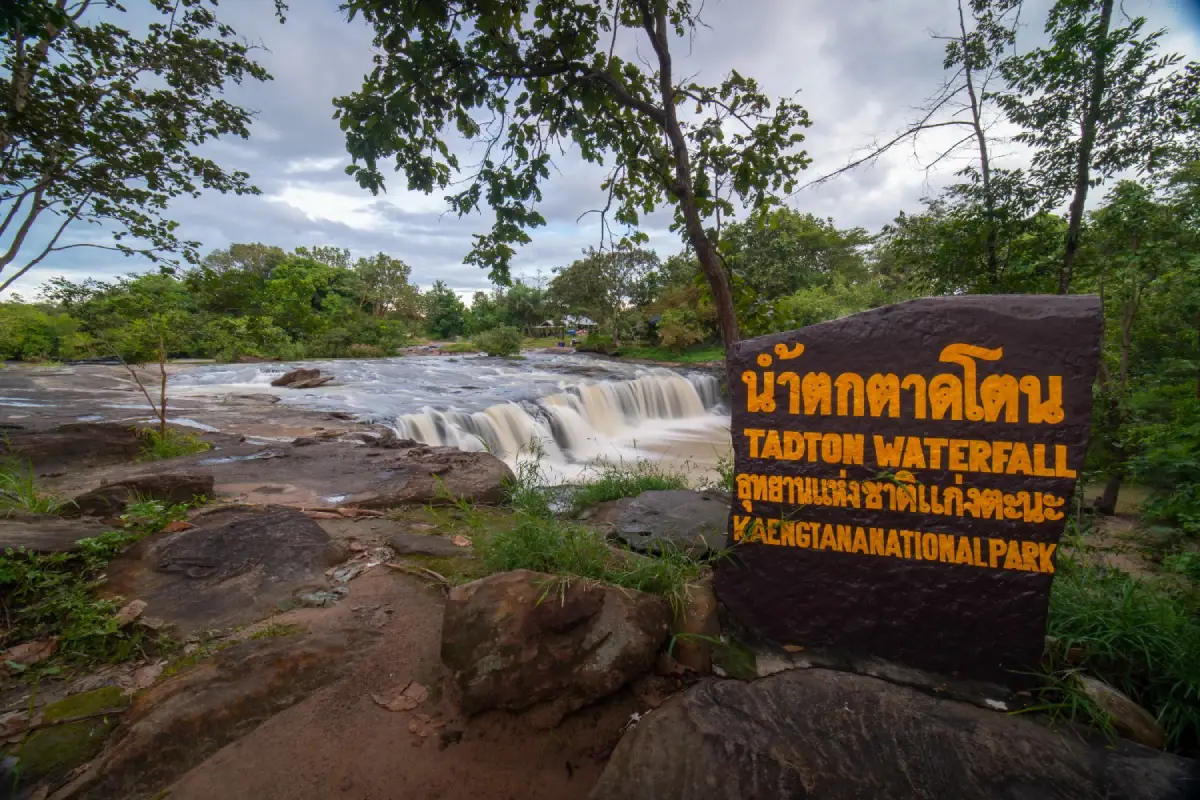
Tat Ton Waterfall in Ubon Ratchathani Province is a natural waterfall located in Kham Khuean Kaeo Subdistrict, Sirindhorn District. It is formed by Huai Tat Ton stream flowing across curved rock layers before dropping into a lower basin and creating a natural pool. The upper section of the waterfall is a broad sandstone rock plain where water flows gently across the surface before descending to the shaded area below. This character makes Tat Ton Waterfall different from high vertical waterfalls. Its beauty lies in the movement of water over rock, the natural pool, the forest shade, and the quiet local atmosphere of eastern Ubon Ratchathani.
The waterfall is suitable for travelers who enjoy simple, nature-based places rather than heavily commercialized attractions. Visitors can sit near the stream, relax on the rock area, enjoy the sound of water, take photographs, and observe the plants growing around the stream. The surrounding forest creates a cool and shaded atmosphere, especially during the late rainy season when the stream has more water and the vegetation is fresh. For Thai and international travelers seeking a deeper view of Ubon Ratchathani, Tat Ton Waterfall offers a local and peaceful nature experience.
The name Tat Ton reflects the shape of the landscape. In local usage, “tat” often refers to a rocky rapid or waterfall-like rock shelf, while “ton” suggests water dropping from one level to another. At this site, water flows across the upper rock plain, meets a curved stone ledge, and drops into the lower pool. The name therefore describes the natural character of the place clearly: a stream, a rock shelf, a drop, and a pool.
Tat Ton Waterfall is located in a travel zone connected with Sirindhorn District, Khong Chiam District, Kaeng Tana National Park, Sirindhorn Dam, the Mun River, and the Mekong River route. This makes it a practical stop for visitors traveling from Ubon Ratchathani city toward Sirindhorn, Chong Mek, or Khong Chiam. The waterfall can be combined with Sirindhorn Dam, raft trips on the reservoir, Kaeng Tana National Park, the suspension bridge, and Wat Sirindhorn Wararam Phu Phrao.
The natural formation of the waterfall shows how water and rock work together over time. Huai Tat Ton stream flows over uneven rock surfaces. Repeated water flow gradually smooths the rock, deepens small channels, and forms natural basins. The pool below the waterfall is part of this long process. Visitors can see how the stream moves across the rock, gathers at lower points, and continues downstream. This makes the site useful for simple nature education as well as recreation.
The best time to visit Tat Ton Waterfall is during the late rainy season, when the stream has enough water to flow clearly over the rock plain and into the pool. The broader June to October period is suitable for waterfall viewing, especially after safe rainfall. During this time, the surrounding forest remains green and the atmosphere is cool. In the dry season, water may decrease, but the rock structure, stream channels, and sandstone surfaces become easier to observe.
The upper rock plain is one of the main highlights. Water flows across the broad surface before reaching the drop. When the water level is moderate, visitors can see a thin sheet of water spreading across the stone, reflecting light and creating a calm visual effect. The lower basin offers a more enclosed and shaded atmosphere, with water, rock, and trees surrounding the pool. Together, these two levels give the waterfall both openness and intimacy.
Families can visit Tat Ton Waterfall for a relaxed nature outing, but children should always be supervised near the water and on wet rock. Sandstone and stream rocks can become slippery, especially after rain. Visitors should avoid running on the rock surface, jumping from stones, or entering water where the depth is unclear. The safest experience comes from choosing calm-water areas and walking carefully.
For photographers, Tat Ton Waterfall offers several natural compositions: water flowing over the rock plain, the curved rock edge, the lower pool, shaded streamside trees, wet stone textures, and forest reflections. Morning and late afternoon light are usually pleasant for photography. After rain, the water and forest look especially fresh, but the rocks may be slippery, so camera and phone protection is useful.
The area is also suitable for nature learning. Visitors can observe stream erosion, rock polishing, natural pools, seasonal water change, and streamside vegetation. The waterfall shows clearly how a small stream can shape a landscape over time. For students and travelers interested in geology, the site provides an easy example of how water creates rock channels and basins through repeated flow.
Tat Ton Waterfall can be linked with raft trips on Sirindhorn Dam. This gives travelers two types of water landscapes in one trip: a local stream waterfall and a large reservoir. The raft route offers wide water views, while Tat Ton Waterfall offers close contact with rock, stream, forest, and natural pools. This combination is especially suitable for travelers who want a full-day nature route in Sirindhorn District.
Kaeng Tana National Park is another important nearby destination. It includes Kaeng Tana rapids, Don Tana island, the suspension bridge across the Mun River, Tham Phra, Lan Pha Phueng, Kaeng Khan We, and historical traces such as the Chitrasen inscription. Combining Tat Ton Waterfall with Kaeng Tana National Park allows visitors to experience both a stream waterfall and the wider Mun River landscape.
Sirindhorn Dam adds another dimension to the route. The dam is a major water and power landmark in Sirindhorn District and is also a recreation area. Visitors can enjoy reservoir views, food near the dam, and nearby routes toward Chong Mek and Wat Sirindhorn Wararam Phu Phrao. This makes Tat Ton Waterfall convenient for travelers who want to combine water, forest, reservoir, and temple viewpoints.
Wat Sirindhorn Wararam Phu Phrao is a popular evening stop in the same broader district. Many travelers visit the waterfall or dam during the day and finish the trip at the temple in the evening. The temple is known for its glowing tree artwork and elevated views. This route gives visitors a balanced day of nature and cultural travel.
Getting There is easiest by private car or rental car. Visitors can set the navigation point to Tat Ton Waterfall, Kham Khuean Kaeo Subdistrict, Sirindhorn District, or use the coordinates 15.253395, 105.478028. From Ubon Ratchathani city, travel toward Phibun Mangsahan and Sirindhorn District, then continue to Kham Khuean Kaeo Subdistrict. From Sirindhorn Dam, Chong Mek, or Khong Chiam, the route is shorter and can be planned as a half-day trip.
Travelers without private transport can first reach Sirindhorn District or Chong Mek, then arrange local transport to the waterfall. This requires planning because public transport directly to local waterfall areas is limited. For small groups, hiring a local vehicle is more convenient and allows additional stops at Sirindhorn Dam, Kaeng Tana National Park, or Wat Sirindhorn Wararam Phu Phrao.
A half-day plan from Sirindhorn District can begin at Tat Ton Waterfall in the morning. Visitors can spend 2 to 3 hours relaxing, taking photographs, and enjoying the stream. After that, they can continue to Sirindhorn Dam for lunch or a raft activity, then finish the day at Wat Sirindhorn Wararam Phu Phrao. This route is suitable for families and travelers who prefer moderate travel distances.
A full-day plan from Ubon Ratchathani city should start early. Tat Ton Waterfall can be the first nature stop, followed by Sirindhorn Dam or Kaeng Tana National Park. In the late afternoon or evening, visitors can continue to Wat Sirindhorn Wararam Phu Phrao or return through Khong Chiam. This itinerary gives a varied experience of waterfall, reservoir, river, forest, and local viewpoints.
For a slower 2-day trip, visitors can stay in Khong Chiam, Chong Mek, or Sirindhorn. One day can focus on Sirindhorn Dam, Tat Ton Waterfall, raft activities, and Wat Phu Phrao. The second day can include Kaeng Tana National Park, the suspension bridge, Don Tana, Tham Phra, and the Mun-Mekong river route. This gives a deeper understanding of eastern Ubon Ratchathani.
Visitors should prepare simple but useful items: shoes with good grip, water-friendly clothing, drinking water, a small towel, mosquito repellent, a waterproof bag for phones or cameras, and a personal trash bag. During the rainy season, a light raincoat may be useful. Because the rocks can be slippery, footwear is more important than at ordinary sightseeing spots.
Swimming or playing in the water should be done only when water conditions are suitable. The pool may look calm, but depth and rock levels can change suddenly. After heavy rain, water flow can increase quickly. Visitors should avoid strong current areas, wet sloping rocks, and unknown depths. Children and weaker swimmers should stay close to the edge and remain under adult supervision.
Food options are available in nearby zones such as Sirindhorn Dam and Khong Chiam. Restaurants in the area commonly serve Thai food, Isan dishes, fish from local rivers and reservoirs, papaya salad, grilled dishes, and simple local meals. Eating before or after the waterfall visit helps reduce waste inside the natural area and makes the visit more comfortable.
Accommodation can be planned according to the wider travel route. Travelers focusing on Tat Ton Waterfall, Sirindhorn Dam, and Chong Mek can stay around Sirindhorn or Chong Mek. Travelers continuing to Kaeng Tana, the Mun River, or Khong Chiam can stay in Khong Chiam. Riverside resorts and small hotels in Khong Chiam are convenient for visitors who want river views and access to both natural and cultural attractions.
Responsible travel is essential. Visitors should not leave rubbish, use soap or chemicals in the stream, write on rocks, pick plants, disturb wildlife, or make excessive noise. Small waterfalls and stream areas can be damaged easily by careless behavior. Keeping the area clean helps preserve the clear water, rock surfaces, plants, and local atmosphere of Tat Ton Waterfall.
For international travelers, Tat Ton Waterfall shows a quieter and more local side of Thailand. It is not a beach, island, or major city landmark. It is a stream waterfall connected with village geography, rock plains, forest shade, a reservoir route, and the Mun-Mekong travel corridor. This makes it valuable for visitors who want to understand Ubon Ratchathani beyond its most famous destinations.
Overall, Tat Ton Waterfall is a meaningful natural attraction in Sirindhorn District. Its strengths are the broad rock plain, Huai Tat Ton stream, curved rock drop, lower pool, shaded forest, seasonal water flow, and convenient connection with Sirindhorn Dam, Kaeng Tana National Park, Chong Mek, and Khong Chiam. When visited during the right season and with careful preparation, it offers a calm, refreshing, and place-specific experience in eastern Ubon Ratchathani.
| Name | Tat Ton Waterfall |
| Location | Kham Khuean Kaeo Subdistrict, Sirindhorn District, Ubon Ratchathani Province |
| Address | Tat Ton Waterfall area, Kham Khuean Kaeo Subdistrict, Sirindhorn District, Ubon Ratchathani 34350 |
| Coordinates | 15.253395, 105.478028 |
| Distinctive Features | A stream waterfall formed by Huai Tat Ton flowing across curved rock layers and a broad upper sandstone plain before dropping into a natural lower pool, suitable for relaxing, photography, and water play when conditions are safe |
| Name Origin | The name reflects water flowing across a rocky shelf and dropping from one level into a lower pool. |
| Natural Formation | A stream waterfall with rock plains, sandstone surfaces, curved rock ledges, natural pools, shaded streamside forest, and seasonal water flow shaped by repeated water erosion |
| Travel Information | Travel by private car or rental car to Kham Khuean Kaeo Subdistrict, Sirindhorn District, and use the coordinates 15.253395, 105.478028. The route connects conveniently with Ubon Ratchathani, Phibun Mangsahan, Sirindhorn, Chong Mek, and Khong Chiam. |
| Current Status | Open as a local natural attraction in Kham Khuean Kaeo Subdistrict, Sirindhorn District |
| Open Days | Daily |
| Opening Hours | 08.00 – 17.00 |
| Fees | Kaeng Tana National Park Area Rate: Thai Visitors Adult 20 Baht, Child 10 Baht Foreign Visitors Adult 100 Baht, Child 50 Baht 4-Wheel Car 30 Baht Per Vehicle Motorcycle 20 Baht Per Vehicle |
| Facilities | Parking according to site conditions, streamside resting areas, safe water-play spots depending on water level, rock plain, shaded forest, and basic services in Kham Khuean Kaeo community or nearby attractions |
| Main Areas / Zones | Waterfall Access Zone Huai Tat Ton Stream Zone Upper Rock Plain Zone Curved Rock-Ledge Zone Lower Natural Pool Zone Safe Water-Play Zone Streamside Forest And Plant Zone Nature Photography And Resting Zone |
| Caretaker | Kham Khuean Kaeo Subdistrict Administrative Organization, Sirindhorn District, Ubon Ratchathani Province, and Kaeng Tana National Park in the nearby natural-attraction context |
| Main Contact Number | Kham Khuean Kaeo Subdistrict Administrative Organization, Tel. 045-210-741 Kaeng Tana National Park, Tel. 0 4525 2722-3 |
| Best Time To Visit | Late rainy season for the strongest scenic water flow; June to October for seasonal waterfall viewing |
| Safety Notes | Be careful of slippery wet rock, uneven pool depth, stronger flow after rain, and supervise children closely when playing in the water. |
| Nearby Tourist Attractions | 1. Sirindhorn Dam Raft Route, Kham Khuean Kaeo, 6 km, Tel. 045-210-741 2. Sirindhorn Dam, 8 km, Tel. 045-366-081 Ext. 3 3. Kaeng Tana National Park, 13 km, Tel. 0 4525 2722-3 4. Kaeng Tana Suspension Bridge, 13 km, Tel. 0 4525 2722-3 5. Tham Phra / Chitrasen Inscription, 14 km, Tel. 0 4525 2722-3 6. Kaeng Khan We, 14 km, Tel. 0 4525 2722-3 7. Wat Sirindhorn Wararam Phu Phrao, 25 km 8. Chong Mek Border Checkpoint, 29 km, Tel. 045-252-749 |
| Nearby Restaurants | 1. Araya Sirindhorn Dam, 6 km, Tel. 086-877-4204 2. Phae Lam Khong, 7 km, Tel. 091-918-9168 3. Phae Araya Khong Chiam, 8 km, Tel. 045-351-015 4. CAFE DE KHONG, 8 km, Tel. 081-860-5905, 045-351-174 5. Rim Khong Restaurant, 8 km, Tel. 094-285-6322 6. Sirindhorn Dam Food Center, 8 km, Tel. 089-425-4599 7. Boeng Tawan Restaurant, 8 km, Tel. 089-717-7627 |
| Nearby Accommodations | 1. Khong Chiam Hotel, 8 km, Tel. 086-468-7431 2. Tohsang Heritage Khongjiam, 8 km, Tel. 081-860-5905, 045-351-174-6 3. Khong Chiam Orchid Riverside Resort, 9 km, Tel. 098-916-8771 4. Home Kham Resort, Sirindhorn District, 22 km, Tel. 081-379-2608 5. Ban Kiang Fah Resort Chongmek, 30 km, Tel. 099-249-8916 6. Got Baan Suan Resort Chongmek, 30 km, Tel. 086-244-1129 |
Frequently Asked Questions (FAQ)
Q: Where is Tat Ton Waterfall located?
A: Tat Ton Waterfall is located in Kham Khuean Kaeo Subdistrict, Sirindhorn District, Ubon Ratchathani Province.
Q: What are the opening days and hours?
A: Tat Ton Waterfall is open daily from 08.00 to 17.00.
Q: Is there an entrance fee?
A: The Kaeng Tana National Park area rate is Thai adult 20 Baht, Thai child 10 Baht, foreign adult 100 Baht, and foreign child 50 Baht. Vehicle fees also apply by vehicle type.
Q: What are the main highlights of Tat Ton Waterfall?
A: The highlights are the broad upper rock plain, Huai Tat Ton stream, curved rock drop, lower natural pool, shaded forest, and a calm atmosphere suitable for relaxing and water play when conditions are safe.
Q: When is the best time to visit Tat Ton Waterfall?
A: The late rainy season is the best time because the waterfall has more water and the surrounding forest remains green. June to October is generally suitable for seasonal waterfall viewing.
Q: Can visitors swim or play in the water?
A: Visitors can play in the water only when water conditions are safe. Slippery rocks, uneven pool depth, and stronger flow after rain require caution.
Q: How can travelers get to Tat Ton Waterfall?
A: Travelers can use the coordinates 15.253395, 105.478028 or search for Tat Ton Waterfall, Kham Khuean Kaeo Subdistrict, Sirindhorn District. A private car or rental car is the most convenient option.
Q: What attractions can be visited together with Tat Ton Waterfall?
A: Nearby attractions include Sirindhorn Dam raft routes, Sirindhorn Dam, Kaeng Tana National Park, Kaeng Tana Suspension Bridge, Tham Phra, Kaeng Khan We, Wat Sirindhorn Wararam Phu Phrao, and Chong Mek Border Checkpoint.
 Category: ●Nature and Wildlife
 Group: ●Waterfalls
Last Update : 3 MonthAgo
 Last Update : 3 MonthAgo
 Click to Access the Navigation Map GPS
Tad Ton Waterfall Map
Recommend

 Art, Culture and Heritage
 Historical Sites and Monuments(5)
 Landmarks and Memorials(2)
 Royal Palace(1)
 Art, Craft Centres, Tradition(7)
 Museums(3)
 Places of Worship
 Temple(37)
 Other Sacred Sites(4)
 Research and Development
 Royal Project(2)
 Suburban Living
 Village, Community(2)
 Local Market(4)
 National Parks and Marine Reserves(5)
 Mountain (Doi)(6)
 Dam, Reservoir, Lake(8)
Waterfalls(12)
 Hot Springs(1)
 Caves(2)
 River, Canal(11)
 Bays and Beaches(8)
 Islands(2)
 Other natural attractions(6)
 Entertainment and Agricultural
 Zoos and Aquariums(2)
 Animal camps and shows(1)
 Farms, Parks and Ecotourism(1)
 Waterpark(1)
 Travel Articles, Recipes
 Travel Review, Food Review(1)


