
lovethailand home >North Travel Attractions >Lampang Travel Attractions >Mueang Lampang >Phra Bat > Khelang Banphot National Park
TL;DR: Khelang Banphot National Park, open Daily for general visitor service areas. Forest access and nature trails are, hours 08:30–16:30 for general visitor services. Overnight camping follows the park's.

Khelang Banphot National Park
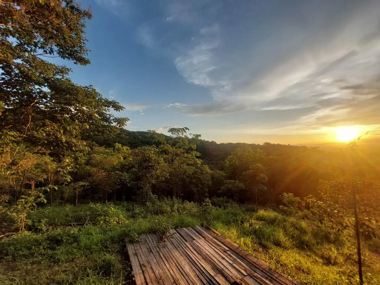
Open Days: Daily for general visitor service areas. Forest access and nature trails are subject to national park regulations.
Opening Hours: 08:30–16:30 for general visitor services. Overnight camping follows the park's designated arrangements.
Khelang Banphot National Park, Lampang Province, Thailand, is a protected forest and nature tourism destination located close to Lampang city. The area is characterized by the mountains of Doi Phra Bat, dry dipterocarp and mixed deciduous forests, scenic ridgelines, nature trails, and the Mon Phaya Chae camping area, which overlooks the city. Its forests play an important role in protecting watersheds and supporting wildfire prevention efforts in Lampang Province. The destination also connects the surrounding natural landscape with the history and cultural heritage of the ancient city of Khelang Nakhon.
One of the park's most distinctive features is its proximity to an urban area. Visitors can experience mountain scenery and natural forests without traveling to a remote national park. Roads from Lampang city lead toward Mon Phaya Chae and nearby cultural attractions, while the surrounding mountains contain complex terrain and valuable habitats. This relationship between the city and the protected landscape gives Khelang Banphot a particularly important place in the province's natural environment.
The proposed national park area covers approximately 94,380 rai, equivalent to around 151.01 square kilometers. It extends across parts of Mueang Lampang, Mae Mo, and Mae Tha districts in Lampang Province. The proposed boundaries incorporate forests associated with the Mae Yang and Mae Ang, Mae Mo, and Mae Chang National Reserved Forests. Together, these areas form a connected mountain and forest landscape that contributes to watershed protection, biodiversity conservation, and environmental management around Lampang city.
The area is administered under the name Khelang Banphot National Park (Under Establishment) by Thailand's Department of National Parks, Wildlife and Plant Conservation. Management activities include forest protection, prevention of offenses involving natural resources, wildfire control, and visitor services in appropriate tourism zones. These responsibilities demonstrate the dual importance of the area as a natural recreation destination and a protected environment closely connected with the province's urban population.
For outdoor enthusiasts, the park offers several attractive experiences. These include the panoramic views at Mon Phaya Chae, the approximately 4.5-kilometer Pha Khang Chang–Kiew Son–Doi Farang nature trail, and areas of two-needle pine forest on the mountain ridges. From the higher viewpoints, visitors can observe landscapes extending toward both Mueang Lampang and Mae Mo districts. The range of activities allows travelers to choose between relaxed sightseeing and more physically demanding forest trekking.
During daylight hours, the viewpoints reveal Lampang city spread across a valley surrounded by mountains. In the evening, sunlight gradually changes the appearance of the ridges, while after dark the city lights create a remarkable scene below the mountain. Visitors often describe these lights as stars on the ground, one of the most memorable features of staying overnight at Mon Phaya Chae.
History of Khelang Banphot National Park is connected with efforts to conserve the forests surrounding Lampang city and to establish a coordinated protection system for the Doi Phra Bat mountain landscape. These mountains form an important part of the terrain east of the city and are closely related to local watersheds, forest habitats, and nearby communities. Protecting the landscape therefore has direct environmental significance for the urban area.
The national park establishment process began with surveys and assessments of national reserved forests considered valuable for conservation. Particular attention was given to the connected mountain landscapes extending across Mueang Lampang, Mae Mo, and Mae Tha districts. The forests include dry dipterocarp and mixed deciduous habitats, as well as scenic mountain areas suitable for environmental education and nature tourism. The proposal therefore combined forest protection with the development of responsible public access.
On July 6, 2022, the Department of National Parks published information about public consultation on the proposed designation of Khelang Banphot National Park. The surveyed area covered approximately 94,380 rai and included forest lands associated with Ban Sadet, Phichai, and Phrabat subdistricts in Mueang Lampang District; Ban Dong and Mae Mo subdistricts in Mae Mo District; and Mae Tha and Hua Suea subdistricts in Mae Tha District. Public participation formed an important part of the process of defining the protected area and considering its relationship with local communities.
Establishing a large protected landscape requires careful consideration of the relationship between forests and settlements. Forests are not isolated from the lives of surrounding residents. They are connected with water resources, environmental conditions, and traditional patterns of natural resource use. Defining appropriate conservation boundaries is therefore important for protecting ecosystems while recognizing the needs and circumstances of nearby communities.
Throughout its management history, Khelang Banphot has undertaken important responsibilities in forest protection and wildfire prevention. These duties are especially significant around Doi Phra Bat, where forested mountains lie close to Lampang city. Seasonal dry conditions can increase the risk of forest fires and their effects on the wider environment. Monitoring and controlling fires are therefore central responsibilities of park personnel, alongside the management of visitor activities.
In April 2026, the Department of National Parks reported on wildfire prevention measures in Khelang Banphot. The measures included a network of 59 intelligent fire-detection cameras installed at risk locations to support monitoring and improve the speed of emergency response. This approach illustrates how conservation management in a mountain area near a city can combine ranger patrols, risk assessment, and modern technology.
Origin of the Name Khelang Banphot reflects the historical name Khelang Nakhon, associated with the ancient city of Lampang. The Thai word banphot means mountain. Together, the words connect the mountainous landscape with the historical identity of the city. The name therefore refers not merely to a particular tourist attraction but to a broader natural environment that has long formed part of Lampang's geographical setting.
Lampang has a long history, and the name Khelang Nakhon remains closely connected with its cultural identity. Applying this historical name to the surrounding mountains creates a meaningful relationship between the old city and its natural landscape. Visitors can consequently explore both the historical heritage of Lampang and the forests that frame the city within a single journey.
Geography and the Doi Phra Bat Mountains define the natural character of Khelang Banphot National Park. The landscape consists of mountains, ridges, valleys, and foothills extending toward nearby communities. Some viewpoints along the higher ridges overlook both Lampang city and the Mae Mo area. Variations in elevation contribute to differences in environmental conditions and vegetation across the proposed protected landscape.
The orientation of the mountains influences airflow, sunlight, and moisture. Exposed ridgelines are generally windier than sheltered valleys, while lower areas can retain more humidity. These local differences affect vegetation and habitat conditions, producing ecological variation even between locations situated within the same continuous forest.
Doi Farang, an important destination along the nature trail, rises to approximately 904 meters above sea level. Its viewpoint provides panoramas toward Mueang Lampang and Mae Mo districts. From this elevation, visitors can appreciate how the urban valley relates to the surrounding highlands and how natural mountain landscapes remain closely connected to the city.
The Doi Phra Bat mountains also contribute to the watersheds of smaller streams and local water sources. Rainwater falling over forested slopes moves through the soil and natural drainage channels before reaching lower areas. Forest cover helps retain moisture and reduce soil erosion that might otherwise increase when steep ground loses its vegetation.
Dry Dipterocarp and Mixed Deciduous Forests are major ecosystems in Khelang Banphot. Dry dipterocarp forests contain trees adapted to seasonal dryness and environmental changes throughout the year. Many species shed their leaves during the dry season, creating a noticeable difference in the appearance and lighting of the forest compared with the rainy months.
Mixed deciduous forests contain a variety of tree species growing together in different canopy layers. Individual species respond differently to water availability, sunlight, and soil conditions, creating habitats for a range of wildlife. Fallen leaves and branches gradually decompose into organic matter, supporting nutrient cycling and soil processes within the forest ecosystem.
At some higher locations, two-needle pine forests create a landscape distinct from the deciduous woodland of lower elevations. Pine trees have recognizable trunks and crowns and can form open stands on exposed slopes. Sunlight filtering through these trees produces attractive scenery, making the pine areas interesting for both nature observation and landscape photography.
The park's forests undergo visible seasonal changes. During the rainy season, vegetation becomes green and vigorous. Cooler months bring more comfortable conditions for outdoor recreation, while the dry season causes many trees to shed leaves and increases the amount of dry plant material on the forest floor. These changes explain why wildfire prevention becomes particularly important during the hottest and driest periods.
Wildlife and Other Organisms depend on the diversity of habitats within the forest landscape. Information about Khelang Banphot mentions wildlife including leopard cats, red junglefowl, and various bird species. These animals occupy different ecological roles, using forests for food, shelter, reproduction, and movement between suitable habitats.
Red junglefowl live in wooded environments and feed largely on the forest floor, depending on vegetation for both food and cover. Leopard cats are small wild predators whose survival relies on the availability of prey and suitable habitat. Protecting the forest therefore supports not only individual animal species but also the ecological relationships between them.
Forest birds contribute to biodiversity through activities such as seed dispersal and the regulation of insect populations. Observing birds is influenced by the time of day, the surrounding environment, and the amount of human disturbance. Quiet, well-preserved habitats generally provide more favorable conditions for wildlife than locations subject to continuous disruption.
Wildlife conservation in Khelang Banphot depends on ranger patrols, law enforcement, and habitat protection. Park personnel monitor illegal hunting and other offenses involving forest resources. Visitors contribute to these efforts by remaining within authorized areas and avoiding activities that disturb animals or damage their natural habitats.
Mon Phaya Chae is one of the best-known visitor destinations in Khelang Banphot National Park, particularly among travelers who enjoy camping and panoramic views of Lampang city. The area includes a designated camping ground and viewing pavilion. Its elevated position provides striking views of the illuminated city after dark while allowing visitors to enjoy a relatively peaceful natural environment close to the urban center.
The viewpoint's most distinctive feature is its perspective over Lampang. During the day, visitors can observe the city extending across the valley, framed by surrounding mountains. As evening approaches, the scenery changes with the fading sunlight, and after dark the lights of roads and buildings create a completely different view.
The nighttime landscape is especially memorable for campers. From the mountain, countless lights spread across the city below, creating the impression of stars scattered over the ground. The expression stars on the ground captures the contrast between the dark mountain surroundings and the bright urban landscape.
Mon Phaya Chae has a camping area with basic facilities publicly described as including toilets, electricity, parking, and a viewing pavilion. These services make overnight stays more convenient for visitors wishing to experience the mountain atmosphere. Camping remains subject to park regulations, designated spaces, and any operational changes or maintenance affecting the facilities.
Camping at Mon Phaya Chae offers a different experience from staying in a hotel in central Lampang. Visitors can enjoy mountain air, natural surroundings, and a panoramic view over the city directly from the camping area. The quieter nighttime atmosphere creates an appealing setting for simple outdoor recreation, while morning offers an opportunity to observe the changing light over the mountains.
Overnight stays on elevated terrain require equipment suited to cooler temperatures and wind. Although the camping area is relatively close to the city, mountain conditions may be noticeably cooler than those at lower elevations, particularly during winter. Tents should be sturdy and securely anchored, and bedding and clothing should be suitable for outdoor conditions. Campers must use the designated areas established by park personnel.
Responsible campsite management is important for preserving the forest environment and the peaceful atmosphere of Mon Phaya Chae. Food and rubbish must be stored or disposed of appropriately, and loud noise should be avoided. Visitors should not leave the authorized camping area after dark because the surrounding terrain includes natural slopes and wildlife habitats.
The Pha Khang Chang–Kiew Son–Doi Farang Nature Trail is a well-known trekking route within Khelang Banphot National Park. The trail extends for approximately 4.5 kilometers and provides opportunities to explore the mountain forests and ridgelines. Its principal attractions include changing forest conditions and open viewpoints overlooking the surrounding landscape.
Pha Khang Chang forms part of the route and is associated with rocky slopes and elevated viewpoints. The terrain offers opportunities to appreciate the mountain landscape, but certain sections may be steep or exposed. Slippery rocks and the absence of natural barriers in some locations make careful movement important. Trekking activities should follow the park's access arrangements and safety rules.
Kiew Son is notable for its ridge environment and the vegetation adapted to more exposed mountain conditions. Walking through this section reveals how wind, sunlight, and slope orientation influence plant distribution. These environmental differences help explain why ridgeline vegetation can differ from the denser woodland encountered at lower elevations.
The route continues toward Doi Farang, approximately 904 meters above sea level. Views from the higher terrain extend toward both Mueang Lampang and Mae Mo. The elevation provides a broad perspective on the transition from urban settlements to forested mountains and allows visitors to appreciate the regional geography of Lampang Province.
Across its approximately 4.5 kilometers, the trail passes through several types of natural scenery, including shaded forest, hillside paths, rocky sections, and open viewpoints. These changes make trekking an opportunity not only for physical activity but also for observing the relationship between soil, rock, vegetation, weather, and terrain.
Visitors planning to walk the trail should be physically prepared and wear footwear suitable for natural mountain paths. Steep sections and wet surfaces can become slippery after rainfall. Drinking water, practical clothing, and essential personal equipment are important. Trekking should follow authorized routes and the operating times established by park staff.
Two-Needle Pine Forests give parts of the highland landscape a character different from the dry dipterocarp forests of the foothills. Two-needle pine trees have long, narrow needles growing in pairs and can thrive in particular upland environments. Where they occur along exposed ridges, they form relatively open woodland that allows sunlight to reach the ground.
Pine forests also have ecological importance as habitats and resource areas for various organisms. Fallen needles and other organic material contribute to soil conditions and nutrient cycling. Observing pine woodland provides a useful opportunity to compare exposed ridge environments with denser and more sheltered forest habitats.
Huai Cho Reservoir is a water feature associated with the Mon Phaya Chae area and the surrounding foothills. Its landscape contributes to the natural setting of the area and reflects the relationship between forests and local water resources. The reservoir and nearby terrain are connected with the broader importance of watershed management around Lampang.
Foothill water sources receive runoff from streams and mountain catchments. Their condition is closely related to the health of the upstream forests, which influence water flow, sediment movement, and environmental quality. Protecting mountain vegetation therefore contributes to maintaining the resources used by lower-elevation communities.
Wang Huea Reservoir and Local Streams are further natural water features associated with the Khelang Banphot landscape. Streams and reservoirs illustrate how mountainous terrain collects and channels rainfall toward lower areas. These water systems are valuable to the local environment and demonstrate the importance of managing watersheds as connected natural systems.
Water conditions change throughout the year. Continuous rainfall increases stream flow, while dry-season conditions can reduce available water. These variations highlight the importance of maintaining forest cover in regions with pronounced seasonal changes in rainfall. Healthy upland forests contribute to water quality and the long-term stability of downstream environments.
Wat Mon Phaya Chae is a Buddhist temple closely associated with the mountain landscape and tourism around Mon Phaya Chae. Located in Phichai Subdistrict, Mueang Lampang District, it contains a revered religious monument and a worship area on elevated ground. The temple is an important cultural destination for nearby communities and provides another viewpoint over Lampang city.
The temple's distinctive setting on a hill allows visitors to experience both Buddhist cultural heritage and mountain scenery. Reaching the religious area involves moving uphill toward the monument, where the landscape opens toward the city. The quiet surroundings make the temple an attractive cultural stop in combination with the nearby natural attractions.
Although Wat Mon Phaya Chae and the park are geographically connected, their purposes and visitor practices differ. Temple visitors should dress respectfully, observe appropriate behavior in religious spaces, and avoid unnecessary noise. Within the national park, additional conservation and safety regulations apply.
Wildfire Prevention at Khelang Banphot is directly connected with Lampang's environmental conditions. Because the forests lie near residential areas, seasonal fires can threaten natural resources and affect air quality in nearby communities. Protecting Doi Phra Bat is therefore important not only for forest conservation but also for reducing the consequences of smoke and airborne particles.
During the northern Thai dry season, fallen leaves and other natural fuels become increasingly dry. Once ignited, fire can spread through combustible material and affect connected forest areas. Forest monitoring and rapid intervention are therefore essential parts of limiting ecological damage.
Modern detection technology forms part of the park's wildfire management approach. Intelligent cameras installed at risk locations support monitoring and help identify incidents quickly. Combining this technology with field personnel improves the ability to respond to fires, particularly on mountain slopes that are difficult to access.
Visitors also have a responsibility to minimize fire risks. Cigarette ends must never be discarded in the forest, fires must not be lit outside authorized locations, and rubbish or natural materials must not be burned. Respecting these rules reduces the likelihood of human-caused fires and helps preserve the forest environment.
The Park's Importance to Air Quality in Lampang is connected with the protection of surrounding forests and the management of seasonal wildfires. Smoke and fine particles generated by fires on mountain slopes can move toward populated areas according to wind conditions. With forest land situated close to the city, preventing fires is particularly important for residents.
Forest conservation also provides broader environmental benefits, including soil protection, watershed support, and wildlife habitats. Protecting Khelang Banphot therefore contributes to natural resources closely connected with everyday life in Lampang, distinguishing it from remote protected areas with little direct interaction with urban settlements.
Best Seasons to Visit Khelang Banphot depend on the chosen activity. The cooler months, approximately November through February, are well suited to camping and outdoor sightseeing. Rainy months bring lush forest scenery, while the hot season requires greater attention to dry conditions, air quality, and wildfire risks.
Camping at Mon Phaya Chae is particularly attractive during the cooler season, when evening and nighttime temperatures make outdoor stays enjoyable. Visitors can admire Lampang's city lights from the mountainside and wake up to the morning landscape. However, wind and temperature can change, so suitable bedding and clothing remain important.
During the rainy season, forest vegetation becomes greener and the landscape receives more moisture. The nature trail can look very different from its dry-season appearance, but wet soil and rock surfaces increase the risk of slipping, especially around cliffs and ridgelines. Trekking should therefore take place only when weather conditions and park access arrangements allow safe travel.
The hot season brings drier vegetation and greater amounts of leaf litter on the forest floor. Some days can be very hot, while regional wildfire activity may also affect air quality. Visits during this period should take account of local environmental conditions and any temporary closures of high-risk areas.
Family-Friendly Nature Activities focus on scenic viewpoints and accessible visitor service areas. Travelers who do not wish to undertake long treks can enjoy mountain panoramas, observe Lampang city from above, and combine the trip with a visit to Wat Mon Phaya Chae. This approach offers a convenient combination of outdoor recreation and cultural sightseeing.
Photography enthusiasts will find Mon Phaya Chae particularly interesting for its changing views of Lampang city and the mountains. The Pha Khang Chang–Kiew Son–Doi Farang route offers a different photographic experience, emphasizing natural ridges, rock formations, and pine forests. All photography should take place from safe locations, avoiding unprotected steep ground and unstable rocks.
Environmental Education at Khelang Banphot includes opportunities to learn about deciduous forests and mountain geography. Changes in vegetation between the foothills and higher ridges illustrate differences in moisture, sunlight, soil, and exposure. Observing these features along an authorized nature trail helps visitors understand the interdependence of organisms and environmental conditions.
Watershed education is another important aspect of the park. Mountain forests receive rainfall and channel water toward streams and lower settlements. When forest soils retain healthy vegetation and organic material, water can infiltrate the ground and move through natural drainage systems more effectively. Understanding these processes reveals the relationship between forest conservation and the water resources used by local communities.
Combining the Park with Lampang's Cultural Attractions creates a varied travel experience. Nearby destinations include Wat Mon Phaya Chae, Wat Phra Kaeo Don Tao Suchadaram, Wat Chedi Sao Lang, Baan Sao Nak, and the Kad Kong Ta historic district. Each location has a different identity involving Buddhist art, local history, traditional houses, or community culture.
Wat Phra Kaeo Don Tao Suchadaram is a significant Buddhist temple known for its historical and artistic importance in northern Thailand. Wat Chedi Sao Lang is distinguished by its distinctive group of pagodas, while Baan Sao Nak is a historic timber residence illustrating the architectural heritage of Lampang. Visiting these places adds cultural depth to an itinerary centered on the park's natural attractions.
Kad Kong Ta is a historic commercial district associated with old buildings and trade along the Wang River. Walking through its streets offers a different view of Lampang from the forested mountains of Khelang Banphot. Combining the old town with natural sightseeing provides an experience that includes the province's geography, history, architecture, and contemporary urban life.
Getting to Khelang Banphot National Park is possible from Lampang city by traveling toward the Mon Phaya Chae and Doi Phra Bat areas through Phrabat and Phichai subdistricts in Mueang Lampang District. Roads leading toward the mountain visitor areas include slopes and bends. Drivers should take particular care during rain or when visibility is reduced.
According to publicity information from the Department of National Parks, access from central Lampang toward the Pha Khang Chang–Kiew Son–Doi Farang nature trail is approximately 10 kilometers. This figure describes the general connection from the city rather than the walking distance of the trail itself. The actual nature trail extends for approximately 4.5 kilometers.
Traveling by private vehicle offers practical advantages for visitors planning to see several attractions, since mountain viewpoints and nature sites are not all located directly beside public transport stops. Suitable vehicles, careful driving, and sufficient travel time help make a multi-stop itinerary more convenient and safe.
Visitor Facilities include a camping ground, toilets, electricity, parking, and a scenic pavilion at Mon Phaya Chae. These facilities support outdoor recreation and overnight stays, subject to the park's rules and the operating arrangements in effect at the time of the visit. The accessible camping area is an important feature for travelers wishing to experience nature close to Lampang city.
Responsible Visitor Behavior begins with keeping the park clean, avoiding the removal of plants or natural materials, and never feeding wildlife. Campers must respect park regulations, avoid disturbing other visitors, and remain within designated areas. Responsible use of visitor facilities helps protect the ecosystems that make the destination valuable.
Trekkers must remain on trails authorized by park personnel, particularly around cliffs, ridges, and rocky sections. These environments can be hazardous in unfavorable weather, especially when surfaces are wet or visibility is limited. Carrying water, appropriate equipment, and essential supplies is important, as is coordinating entry with the responsible park personnel.
During the dry season, extra caution is required concerning fire. Wildfires can cause extensive damage to vegetation, wildlife habitats, and the air quality of nearby communities. Avoiding all unauthorized flames and reporting suspicious smoke or fire are practical ways visitors can contribute to protecting the forest.
Khelang Banphot's Role in the Local Community includes recreation, environmental protection, watershed conservation, and wildfire management. Its proximity to Lampang city makes the protected landscape particularly meaningful to local residents. The park illustrates how urban life and mountain ecosystems remain closely connected through water, air quality, forest resources, and everyday opportunities for outdoor recreation.
Tourism also connects the mountain landscape with the local economy. Visitors staying overnight or exploring the viewpoints can use restaurants, accommodation, and other services in Lampang city before continuing to historical and cultural attractions. Having a natural recreation destination so close to the urban area broadens the province's tourism opportunities.
Khelang Banphot National Park in Lampang Province offers a valuable combination of mountain scenery, ecological learning, and accessible outdoor recreation. Mon Phaya Chae is known for its panoramic city views and the striking spectacle of stars on the ground after dark. The Pha Khang Chang–Kiew Son–Doi Farang nature trail provides opportunities to encounter forests, mountain ridges, and elevated viewpoints.
The lasting importance of Khelang Banphot extends beyond the beauty of its viewpoints. Its forests help protect watersheds, provide wildlife habitats, and support wildfire prevention efforts near Lampang city. Exploring this landscape offers visitors an opportunity to enjoy the quiet mountain environment while appreciating the close relationship between the historic city of Lampang and the natural mountains surrounding it.
| Place Name | Khelang Banphot National Park (Under Establishment), Lampang Province, Thailand |
| Office Address | Moo 4, Phrabat Subdistrict, Mueang Lampang District, Lampang Province 52000, Thailand |
| Geographical Setting | Doi Phra Bat mountain landscape east of Lampang city, extending across Mueang Lampang, Mae Mo and Mae Tha districts |
| Legal Status | Proposed National Park Under Establishment, with managed conservation and designated visitor areas |
| Proposed Area | Approximately 94,380 rai, or 151.01 square kilometers |
| Administrative Districts | Mueang Lampang, Mae Mo and Mae Tha, Lampang Province |
| Managing Authority | Department of National Parks, Wildlife and Plant Conservation, Protected Areas Regional Office 13, Lampang Branch |
| Park Superintendent | Ms. Duangporn Kiatdamrong, named in an official Department of National Parks report dated April 4, 2026 |
| General Opening Hours | Daily, 08:30–16:30 |
| Contact Number | +66 95 451 7597 |
| Natural Environment | Dry Dipterocarp Forest, Mixed Deciduous Forest, Two-Needle Pine Forest, Mountains, Ridges, Cliffs, Streams and Reservoirs |
| Highlights | Mon Phaya Chae, Night Views of Lampang City, Pha Khang Chang, Kiew Son, Doi Farang and Two-Needle Pine Forests |
| Main Visitor Areas | 1. Mon Phaya Chae – Viewpoint and Camping Area 2. Pha Khang Chang – Mountain and Cliff Trail Area 3. Kiew Son – Ridge and Forest Area 4. Doi Farang – Elevated Viewpoint, approximately 904 meters above sea level 5. Huai Cho – Foothill Reservoir and Surrounding Natural Area |
| Nature Trail | Pha Khang Chang–Kiew Son–Doi Farang, approximately 4.5 km |
| Mon Phaya Chae Facilities | Camping Ground, Toilets, Electricity, Parking and Scenic Viewing Pavilion |
| Visitor Activities | City Viewpoints, Night Photography, Camping, Nature Trekking, Forest Education and Mountain Sightseeing |
| Recommended Season | Approximately November–February for cooler weather and camping |
| Getting There | Travel from Lampang city toward Phrabat and Phichai subdistricts to reach the Mon Phaya Chae and Doi Phra Bat visitor areas, following local park access signs |
| Nearby and In-Park Attractions | 1. Mon Phaya Chae – Park Viewpoint and Camping Area 2. Wat Mon Phaya Chae – Nearby Foothill Temple 3. Huai Cho Reservoir – Mon Phaya Chae Foothill Area 4. Pha Khang Chang – Part of the 4.5-km Nature Trail 5. Kiew Son – Part of the 4.5-km Nature Trail 6. Doi Farang – Nature Trail's Highland Viewpoint 7. Wat Phra Kaeo Don Tao Suchadaram – Lampang City 8. Wat Chedi Sao Lang – Lampang City 9. Baan Sao Nak – Lampang City 10. Kad Kong Ta Historic District – Lampang Old Town |
| Restaurants Around Lampang City | 1. Krua Chat Sombun – Lampang City Area 2. Mong Wang – Lampang City Area 3. Tam Yam at Lampang – Lampang City Area 4. Pae Yim Traditional Soy Milk – Lampang City Area 5. The Riverside Restaurant – Thip Chang Road, Tel. +66 88 251 9818 6. Huan Dahla Restaurant – Lampang City, Tel. +66 64 414 6561 |
| Accommodation Around Lampang City | 1. Mon Phaya Chae Camping Ground – Inside the Park's Visitor Area, Tel. +66 95 451 7597 2. The Coconut Hotel Lampang – Lampang City, Tel. +66 54 821 999 3. Hop Inn Lampang City Center – Lampang City 4. Wienglakor Hotel – Lampang City 5. B2 Lampang City Boutique & Budget Hotel – Lampang City, Tel. +66 54 010 988 6. Khelang Nakorn Hotel – Lampang City, Tel. +66 54 226 137 7. Kim City Hotel Lampang – Lampang City, Tel. +66 54 310 238 |
Frequently Asked Questions (FAQ)
Q: Where is Khelang Banphot National Park located?
A: Khelang Banphot National Park is located in Lampang Province, Thailand. Its proposed conservation area includes parts of Mueang Lampang, Mae Mo and Mae Tha districts. The park office is in Moo 4, Phrabat Subdistrict, Mueang Lampang District.
Q: Is Khelang Banphot National Park open every day?
A: General visitor service hours are listed as 08:30–16:30 daily. Trekking and overnight camping are subject to the park's access rules and operating arrangements.
Q: What are the main viewpoints in Khelang Banphot National Park?
A: Mon Phaya Chae is known for views over Lampang city during the day and its illuminated urban landscape after dark. Other scenic locations are found along the Pha Khang Chang–Kiew Son–Doi Farang nature trail.
Q: Can visitors camp at Khelang Banphot National Park?
A: Yes. Mon Phaya Chae has a designated camping area with basic facilities, including toilets, electricity, parking, and a viewing pavilion. Camping must comply with park regulations and designated access arrangements.
Q: How long is the Pha Khang Chang–Kiew Son–Doi Farang nature trail?
A: The nature trail is approximately 4.5 kilometers long. It passes through forest and mountain terrain and leads toward Doi Farang, approximately 904 meters above sea level.
Q: Why is Mon Phaya Chae famous for its stars-on-the-ground view?
A: From the elevated viewpoint, visitors can see numerous lights spread across Lampang city after dark. Viewed from the mountain, the illuminated streets and buildings resemble stars scattered below.
Q: What is the best time to visit Khelang Banphot National Park?
A: November through February is generally attractive for camping and enjoying cooler conditions. Rainy months bring greener forests, but trekking conditions depend on weather, trail access, and safety requirements.
Q: Why is Khelang Banphot National Park important to Lampang?
A: The park protects mountain forests near the city, supports natural watersheds and wildlife habitats, and plays an important role in wildfire prevention and environmental protection in Lampang Province.
 Category: ●Nature and Wildlife
 Group: ●National Parks and Marine Reserves
Last Update : 2 WeekAgo
 Last Update : 2 WeekAgo

 Click to Access the Navigation Map GPS
Khelang Banphot National Park Map
Recommend

 Art, Culture and Heritage
 Historical Sites and Monuments(2)
 Landmarks and Memorials(5)
 Art, Craft Centres, Tradition(10)
 Museums(4)
 Historic Homes and Cities(1)
 Places of Worship
 Temple(86)
 Other Sacred Sites(9)
 Research and Development
 Royal Project(2)
 Suburban Living
 Village, Community(3)
 Local Market(2)
National Parks and Marine Reserves(6)
 Mountain (Doi)(4)
 Dam, Reservoir, Lake(11)
 Waterfalls(15)
 Hot Springs(1)
 Caves(12)
 Flower Field(1)
 River, Canal(1)
 Bays and Beaches(1)
 Other natural attractions(4)
 Entertainment and Agricultural
 Animal camps and shows(1)
 Farms, Parks and Ecotourism(2)
 Outdoor and Adventure Activities(2)
 Shopping
 Shopping and Night Market(2)
 Spas and Wellness
 Spas and Wellness(1)
 Travel Articles, Recipes
 Travel Review, Food Review(1)


