
lovethailand home >North Travel Attractions >Chiang Rai Travel Attractions >Thoeng >Tap Tao > Phu Chi Fa National Park
TL;DR: Phu Chi Fa National Park, Chiang Rai attractions : Nature and Wildlife, National Parks and Marine Reserves.

Phu Chi Fa National Park
Open Days: Daily. The park reopened tourism and camping activities in the designated Phu Chi Fa summit viewpoint area on September 1, 2026.
Opening Hours: 04:30–18:00 for general viewpoint access. Vehicle restrictions and camping arrangements follow park regulations.
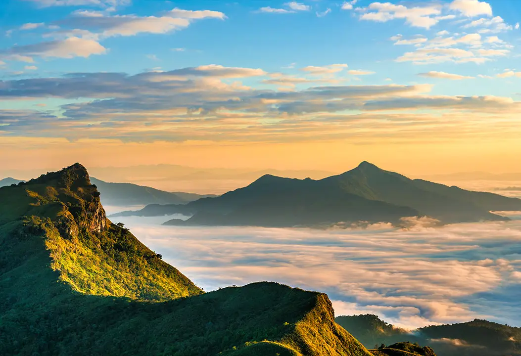
Phu Chi Fa National Park, Chiang Rai Province, Thailand, is one of northern Thailand's best-known mountain destinations, celebrated for its sunrise views and spectacular sea of mist. The principal viewpoint is located near Ban Rom Fa Thai, Tap Tao Subdistrict, Thoeng District, Chiang Rai Province, close to the Thai–Lao border. Its most recognizable feature is a sharply pointed mountain summit extending eastward, as though pointing toward the sky. Rising approximately 1,628 meters above sea level, Phu Chi Fa has an open grassy summit and a dramatic cliff overlooking the mountain ranges and valleys of Laos.
Phu Chi Fa is a major cool-season destination because it combines several distinctive natural features in one location: high mountain ridges, summit grassland, steep cliffs, early morning sunlight and clouds of mist gathering over deep valleys. The appearance of the landscape changes with the seasons and the weather, allowing visitors to experience different atmospheric conditions throughout the year.
The mountain is particularly popular from October through February, when cooler temperatures and favorable atmospheric conditions increase the possibility of seeing a sea of mist. Many visitors spend the night in accommodation near the mountain before waking early and walking to the summit viewpoint. Watching the first sunlight appear above the mountain ridges and mist is the experience for which Phu Chi Fa is most widely known.
Although Phu Chi Fa is strongly associated with winter scenery, its natural environment has something to offer in other seasons as well. The rainy months bring lush green grassland and humid mountain forests. During the transition into the cool season, wildflowers appear along parts of the ridges. In the hotter months, grasses and some vegetation change color as moisture decreases. These seasonal differences also make the area valuable for observing highland ecology.
History of Phu Chi Fa is closely connected with the mountainous border landscape and the development of communities along the Doi Pha Mon range. In earlier decades, the mountains near the Thai–Lao border had strategic importance and were associated with the activities of the Communist Party of Thailand. The difficult terrain, steep cliffs and elevated ridgelines provided locations suitable for defensive positions and observation. As security conditions changed and transportation improved, the area became increasingly accessible to the public.
The construction and improvement of roads along the border, connecting Doi Pha Tang, Phu Chi Fa and the Chiang Kham area, significantly improved access. What had previously been a remote mountain landscape with limited transportation gradually became a destination for travelers. Phu Chi Fa began receiving wider tourism attention around 1991, when its distinctive cliff and mist-covered valleys attracted growing interest among mountain enthusiasts.
The area was subsequently surveyed for designation as a forest park. Approximately 2,500 rai were identified for the original Phu Chi Fa Forest Park, which the Royal Forest Department formally established on February 6, 1998. This designation provided an administrative framework for natural resource protection, visitor management and conservation of the mountain landscape.
As the conservation importance of the wider Doi Pha Mon landscape received further attention, government agencies began investigating the establishment of a larger national park. The process involved surveying the forests, assessing boundaries, examining relationships with existing communities and preparing information for legal designation.
On June 16, 2017, the Department of National Parks assigned personnel to lead the proposed Phu Chi Fa National Park during its establishment process. During 2018 and 2019, Chiang Rai Province appointed committees to monitor forest surveys and the progress of the national park proposal. These activities formed part of an effort to protect the wider border mountain environment and its natural resources.
On February 5, 2026, the Department of National Parks reviewed wildfire prevention operations along the Chiang Rai–Phayao border region and called for progress in establishing Phu Chi Fa National Park. The activities emphasized the continuing importance of protecting the mountain forests and coordinating conservation work with local communities, particularly in relation to cross-border wildfire risks.
The area is currently administered as Phu Chi Fa National Park (Under Establishment) by Thailand's Department of National Parks, Wildlife and Plant Conservation. Management responsibilities include forest conservation, tourism services, visitor safety and appropriate control of access to sensitive mountain environments. These measures support tourism while helping preserve the area's natural character.
Origin of the Name Phu Chi Fa comes from the distinctive shape of the mountain. Its pointed cliff projects toward the east and resembles a finger reaching toward the sky. This remarkable form has become the defining symbol of the destination and explains the Thai name, which can be understood as the mountain that points to the sky.
Local people on both sides of the border formerly referred to the striking summit as Phu Fa, reflecting its height and dramatic appearance. The name Phu Chi Fa later became widely used as tourism developed. The mountain's name is therefore directly connected with its physical shape rather than being simply a promotional expression.
Geography of Phu Chi Fa forms part of the Doi Pha Mon mountain range along the Thai–Lao border. The landscape rises from approximately 1,200 meters to a maximum elevation of around 1,628 meters above sea level. The eastern side is characterized by steep cliffs, while the western side slopes toward the access routes and surrounding communities. This contrast makes the summit a particularly impressive natural viewpoint.
Unlike forested summits covered entirely by large trees, the top of Phu Chi Fa has extensive areas of open grassland. The absence of dense vegetation provides unobstructed views toward the east, where mountains and valleys extend into Laos. The pointed cliff projecting from the summit forms the mountain's most recognizable feature and distinguishes it from many other viewpoints in northern Thailand.
The cliffs are also significant from a geological perspective. Their form reflects the arrangement and long-term changes of rock layers within the mountain range. The eastern slopes are particularly steep, while the western side has a different gradient. Geological processes over long periods created the distinctive ridges and cliff faces visible today.
Thailand's Department of Mineral Resources identifies Phu Chi Fa and Doi Pha Tang as important parts of the high mountainous landscape along the border. The steep rock formations and connected ridges illustrate considerable differences in elevation over relatively short distances. From Phu Chi Fa, visitors can observe several layers of mountains descending toward the east.
Sunrise at Phu Chi Fa is the mountain's principal attraction. The summit faces east, where the sun rises beyond the mountains of Laos. Its elevated position provides broad views of the first light appearing above the horizon. On mornings with a sea of mist, the sunlight illuminates the clouds below and creates an especially memorable scene.
Before sunrise, the sky gradually changes from darkness to deep blue, followed by orange and golden tones near the horizon. When moisture conditions are suitable, mist gathers in the valleys and takes on the changing colors of the sunlight. This transformation happens continuously over a relatively short period, making the wait before sunrise part of the experience.
Visitors wishing to see sunrise generally begin their walk from the designated parking or transfer area before dawn. A flashlight and warm clothing are important because the summit can be cold and windy. Arriving before the sun appears provides time to reach the viewpoint safely and enjoy the changing morning atmosphere.
The Sea of Mist at Phu Chi Fa is formed when humid air cools sufficiently for water vapor to condense into tiny suspended droplets. Valleys often retain cool air, providing favorable conditions for mist to accumulate. Viewed from the higher summit, the mist spreads across the lowlands like a vast white sea, while some mountain peaks remain visible above it.
The density of the mist varies from day to day. On some mornings, clouds fill the valleys completely; on others, thin fog follows streams and lower slopes. Temperature, humidity, wind and previous weather conditions all affect its appearance. The sea of mist is therefore a natural phenomenon rather than a guaranteed daily event.
One of the most remarkable aspects of the view is the landscape of Laos visible from the Thai summit. Several layers of mountains appear through the mist, creating considerable depth. As the sun climbs higher, the cloud formations shift and gradually become thinner, revealing additional details of the terrain below.
Views Toward Laos are another characteristic feature of Phu Chi Fa. The mountain stands close to the international border and has an open eastern outlook. On clear days, visitors can see mountain ranges, valleys and extensive terrain across the border. This international geographical setting distinguishes Phu Chi Fa from many inland mountain viewpoints.
The border location also makes safety and access rules particularly important. Visitors must remain in authorized viewing areas and avoid moving beyond marked paths or approaching exposed cliffs. Some locations are close to the international boundary, while the terrain itself presents a significant risk because of steep drops.
The Summit Grassland gives Phu Chi Fa its distinctive open appearance. Grasses and low-growing plants cover extensive sections of the upper mountain, with wildflowers appearing during suitable seasons. Rainy months bring fresh green growth, while cooler and drier conditions change the colors of the grassland.
Highland grassland has ecological value because its plants help protect the soil and support smaller organisms. Root systems stabilize the ground along mountain ridges, and repeated trampling can damage vegetation and create erosion channels. Visitors should remain on established paths to help preserve the natural environment.
Melastoma Flowers at Phu Chi Fa add color to the highland grassland. These flowers have pinkish-purple tones and can appear during appropriate seasonal conditions. Tourism information identifies approximately July through January as a flowering period in the area. Their colors contrast with the grasses and distant ridges, providing another natural attraction beyond the sea of mist.
Observing wildflowers demonstrates that high mountain environments support diverse plant life even where large trees are scarce. Many small plants have life cycles closely connected with rainfall and temperature. Grassland protection consequently helps conserve plant species and the insects that depend on their flowers.
Wild Orchid Tree Blossoms are another seasonal highlight. Around February, white blossoms appear on suitable trees along sections of the mountain landscape, creating a contrast against the slopes and surrounding vegetation. This flowering period is part of the natural seasonal cycle of the Doi Pha Mon highlands.
The Phu Chi Fa area has a history of community tourism activities celebrating the blooming of these flowers during February. Such events connect seasonal nature observation with local cultural activities. Exact festival schedules depend on the arrangements made by local organizers each year.
Forests and Ecosystems of the Doi Pha Mon Range vary with altitude, moisture and topography. Some slopes support plants adapted to dry periods, while more humid locations support other forms of vegetation. These differences create several kinds of habitat for plants and animals and contribute to the ecological significance of the Phu Chi Fa landscape.
High mountain ecosystems differ from lowland environments because temperatures are generally lower and exposure to wind can be greater. Some ridges contain open grassland, while sheltered valleys may support denser tree growth. This environmental variation gives the mountain range a diverse appearance even over relatively short distances.
Soil and Water Conservation is important on Phu Chi Fa because of the steep mountain terrain. Rainfall is absorbed partly by soil and vegetation, while additional water flows downhill into natural streams. Plant cover reduces surface erosion and slows runoff, helping maintain the stability of mountain slopes and water systems serving surrounding communities.
Areas receiving heavy foot traffic require particular management because repeated trampling can compact the soil and create worn paths. When steep ground loses its vegetation, rainfall can erode the surface more rapidly. Clearly defined walking routes therefore contribute to long-term conservation of the mountain environment.
Wildlife at Phu Chi Fa depends on the surrounding forests and mountain grassland. Different organisms use the landscape for feeding, shelter and reproduction. Birds and insects form part of the natural ecosystem, while many larger animals avoid areas with heavy visitor activity. Keeping noise levels low and avoiding disturbance helps protect their habitats.
Cool, misty mornings create moisture on grasses and other plants. These conditions are important for small organisms, while sunlight filtering through the mist creates striking scenery. Observing the environment provides opportunities to understand relationships among temperature, humidity and ecology at higher elevations.
Walking to the Phu Chi Fa Summit Viewpoint is the main activity for most visitors. The route ascends from the designated parking area toward the upper ridge. Walking distance depends on the parking arrangements and route in use. The terrain slopes uphill and can be cold, windy or misty, particularly before sunrise.
The walk offers changing scenery as visitors gradually gain elevation. Lower sections reveal hillside vegetation and grassland, while higher sections open toward distant mountains. Walking before dawn adds another dimension to the experience as the sky gradually brightens during the ascent.
Some sections of the path are steep. Older visitors and those who find uphill walking difficult should allow adequate time. Footwear should provide good traction because moisture from rain or mist can make the ground slippery. Flashlights are essential for walking before daylight.
Safety Near the Cliffs is particularly important because the eastern side of the summit drops steeply toward the Lao landscape. Approaching the edge can be dangerous, especially in strong winds or thick mist. Visitors should remain within designated viewing areas rather than stepping onto hazardous ground for photographs.
Popular sunrise periods can bring considerable numbers of visitors onto the paths and viewpoints. Maintaining reasonable spacing and avoiding sudden overtaking reduces the risk of falls. Photography equipment should also be used with consideration for other visitors sharing the limited space.
Vehicle Management During Peak Tourism Periods is necessary because parts of the mountain access road are steep and parking space is limited. On some major holiday dates, park authorities have restricted private vehicles during early morning hours and operated shuttle services from designated parking points. These measures reduce congestion and improve safety.
Community shuttle services form part of the broader visitor management system. They help distribute parking away from sensitive or crowded mountain roads while creating opportunities for local transport operators. Shuttle arrangements therefore contribute both to traffic management and local tourism services.
Camping and Overnight Stays at Phu Chi Fa are popular during cooler months. Staying in the foothill communities allows visitors to prepare for an early morning ascent. Accommodation includes designated camping areas, guesthouses, resorts and community-operated lodging near the mountain.
Overnight stays must be confined to authorized areas. The summit cliff and surrounding grassland should not be treated as unrestricted camping locations because of safety, border and environmental considerations. Using established campsites helps prevent damage to vegetation and reduces exposure to hazardous terrain.
Nighttime and early morning temperatures at high elevation can be considerably lower than in Chiang Rai city. Campers should bring appropriate clothing, bedding and equipment suited to mountain winds. Tents must be securely anchored and pitched only on permitted ground.
Visitor Services Around Phu Chi Fa include parking areas, toilets, information points and designated accommodation or camping facilities. Restaurants and lodging are also available in Ban Rom Fa Thai and nearby communities. Their proximity allows travelers to enjoy the mountain without needing to stay on the exposed summit.
Ban Rom Fa Thai is one of the most important communities serving Phu Chi Fa visitors. Located in Tap Tao Subdistrict, Thoeng District, it offers accommodation, food and tourism services close to the mountain access route. Its position makes it convenient for travelers intending to reach the summit before sunrise.
Tourism in Ban Rom Fa Thai supports lodging, restaurants, transport services and local commerce. Visitors can experience the atmosphere of a highland community and observe livelihoods influenced by mountain geography and seasonal weather. Local residents also play an important role in assisting travelers and maintaining orderly tourism services.
Highland Community Life in the Doi Pha Mon Range is culturally diverse. Communities along the border include Hmong residents and other ethnic groups with different settlement histories. Local livelihoods are associated with highland farming, trade and the growing tourism economy surrounding Phu Chi Fa.
Cooler mountain conditions influence the cultivation of certain crops and the organization of farming activities. Visitors can encounter agricultural products and community traditions connected with the highland environment. Tourism therefore provides opportunities to understand the relationship between geography, livelihoods and local culture.
Phu Chi Dao is another celebrated mountain viewpoint in Chiang Rai Province. Located near Ban Rom Pho Ngoen, Po Subdistrict, Wiang Kaen District, it lies approximately 10 kilometers from Phu Chi Fa. The viewpoint is known for extensive mountain panoramas and distant views toward the Mekong River landscape. It can be combined with Phu Chi Fa in a broader highland itinerary, although its access requirements are different.
The ascent to Phu Chi Dao includes steep sections and an unpaved mountain road. Four-wheel-drive vehicles are used to reach the upper parking area, followed by a walk of approximately 200 meters to the viewpoint. The exposed ridgeline requires care, particularly when winds are strong or visibility is reduced by mist.
Phu Chi Dao is valued for its broad views and the possibility of seeing sunrise above a sea of mist. Its ridge formations and viewing angles differ from those of Phu Chi Fa, providing a complementary experience for travelers exploring the border mountains.
Phu Chi Duean is another highland viewpoint in Po Subdistrict, Wiang Kaen District. It is associated with impressive mountain scenery and mist-covered valleys and can be included in an itinerary linking Phu Chi Fa and Phu Chi Dao. Its elevated terrain and mountain access routes require different arrangements from attractions located directly beside major roads.
The attraction of Phu Chi Duean is the opportunity to appreciate the same wider mountain range from another perspective. Phu Chi Fa, Phu Chi Dao and Phu Chi Duean have distinct ridgelines, elevations and viewing directions, making a combined trip a varied experience of the northern border landscape.
Doi Pha Tang is a significant mountain destination in Po Subdistrict, Wiang Kaen District, approximately 25 kilometers from Phu Chi Fa along the tourism route. It is known for steep cliffs, highland viewpoints and panoramas over the Mekong River winding through the Lao landscape.
The broader Doi Pha Tang mountain area reaches approximately 1,800 meters above sea level. Important viewpoints include Chong Pha Bong, where visitors can enjoy extensive views of the mountains and the Mekong River. The region is also valuable for understanding the geology and topography of the Thai–Lao border mountains.
The cultural history of Doi Pha Tang includes the settlement of Chinese Haw communities associated with former military migration, along with Hmong and Yao communities. The area is known for growing cool-climate crops such as plums, peaches, pears and tea. A visit therefore combines scenery with the history and livelihoods of mountain communities.
Wild Himalayan Cherry and White Mountain Blossoms at Doi Pha Tang contribute to the highland landscape during cooler months. Pink cherry blossoms may appear around December and January, while white mountain flowers add seasonal color in February. Flowering periods make the Phu Chi Fa–Doi Pha Tang route attractive beyond sunrise viewing alone.
Phu Sang National Park is another natural destination that can be connected with a journey to Phu Chi Fa. Located in Phayao Province, it is known for Phu Sang Waterfall and its forest environment. Its landscape offers a contrast to the exposed summit and mist-covered ridges of Phu Chi Fa.
Routes connecting Phu Chi Fa with Ban Huak and Chiang Kham provide access toward Phu Sang National Park. This journey links natural attractions in Chiang Rai and Phayao provinces, including upland settlements, forest scenery and waterfalls.
Winter at Phu Chi Fa is the most popular season because of cooler temperatures and the possibility of a sea of mist. Before sunrise, the atmosphere can be quiet and cold. As the sun appears above the mountains, its light combines with clouds and mist to create one of the most recognizable landscapes in northern Thailand.
November through January is especially popular for overnight stays in communities below the summit. Remaining nearby makes the pre-dawn journey easier. During long holidays, visitor numbers can be high and shuttle arrangements may apply. Spending additional time in the community also allows travelers to experience the mountain atmosphere beyond the sunrise itself.
Phu Chi Fa During the Rainy Season is characterized by green grassland and clouds moving through the mountain ridges. Rainfall encourages plant growth and creates a humid environment. However, wet trails can be slippery and thick mist may reduce visibility. Safety management and seasonal restoration closures are therefore particularly important during wetter months.
Seasonal closures serve both visitor safety and environmental recovery. Heavily used mountain paths can be damaged when soils are saturated, increasing erosion and trampling impacts. Temporarily restricting access can help protect the grassland and maintain suitable conditions for future visitors.
Summer at Phu Chi Fa brings drier conditions and a landscape different from that of winter. Some grasses turn yellow or brown as moisture decreases, while smoke or haze can reduce visibility on certain days. Summer travel requires attention to heat, sunlight and wildfire prevention measures affecting mountain and forest areas.
Wildfire Prevention at Phu Chi Fa is essential for conserving the Doi Pha Mon forests. Highland grassland and other vegetation can become dry during the hot season. When natural fuels accumulate, fire may spread quickly along slopes. Ranger patrols and restrictions on potentially hazardous activities are important parts of protecting the area.
The proximity of the international border makes wildfire management more complex because mountain environments continue across national boundaries. Smoke and fires can affect forests and communities on both sides. Preventing unauthorized burning and avoiding activities that create sparks are important responsibilities for everyone entering the natural environment.
Getting to Phu Chi Fa from Chiang Rai City generally involves taking Highway 1020 toward Thoeng District, followed by Highway 1155 and connecting mountain roads toward Ban Rom Fa Thai. The total journey is approximately 110–115 kilometers, depending on the route used. The landscape changes from urban and rural lowlands to winding mountain roads.
The distance from Chiang Rai city to Thoeng is approximately 64 kilometers, followed by the uphill journey toward Phu Chi Fa. Some sections of the mountain road are steep and winding. Vehicles should be in sound mechanical condition, and drivers should take particular care during rain, fog and reduced visibility.
Getting to Phu Chi Fa from Phayao Province is possible via Highway 1021 through Chiang Kham, followed by Highway 1093 through the Ban Huak and Phu Sang areas. The route connects natural attractions across Phayao and Chiang Rai provinces and passes a variety of highland communities and landscapes.
Published travel information describes a journey of approximately 150 kilometers from Phayao city to Phu Chi Fa along this route. The roads include both lowland and mountain sections. Travel times should allow for winding roads and weather conditions, particularly during the rainy season.
Getting There from Chiang Khong and Wiang Kaen offers another scenic approach through the Doi Pha Tang area and roads following the border mountains. This route is particularly suitable for travelers wishing to visit several highland destinations in the same region.
Visitors planning to watch sunrise often stay overnight in Ban Rom Fa Thai or nearby communities. Driving from Chiang Rai city in the early morning involves a long distance on mountain roads, while staying near the viewpoint allows more time to prepare before dawn.
Accommodation Around Phu Chi Fa includes resorts, guesthouses and locally operated homestays. Some properties are near the main summit access route, while others are along roads connecting Phu Chi Dao and Doi Pha Tang. Options range from individual cabins to family accommodation and camping facilities.
Several lodging establishments provide meals and services for guests preparing to leave for the sunrise viewpoint early in the morning. Staying within the local communities provides an opportunity to experience the highland atmosphere and contributes to locally operated tourism businesses.
Restaurants and Food Services Around Phu Chi Fa are available in Ban Rom Fa Thai and nearby villages. Options include made-to-order Thai meals, restaurants associated with guesthouses and beverage services for visitors. Hot meals are especially welcome in the cool mountain climate, particularly during early mornings and evenings.
Highland communities also offer agricultural produce and foods associated with their local cultures. Seasonal ingredients and produce reflect the cooler climate and agricultural practices of the region, adding another dimension to a visit focused on the mountain landscape.
Photography at Phu Chi Fa is distinguished by the broad scenery and changing morning light. Before sunrise, mountain ridges appear as silhouettes against the gradually brightening sky. When the sun emerges, orange and golden light spreads across the mist. Later, stronger daylight reveals details of the grassland and surrounding terrain.
Beyond mist and sunrise, visitors can photograph seasonal wildflowers, grassland and the pointed cliff that defines the destination. Photography should be conducted without damaging vegetation or entering hazardous locations near the cliff. Preserving the landscape is essential to maintaining its value for future visitors.
Family Visits to Phu Chi Fa are possible because the foothill visitor areas can be reached by vehicle and the main attraction involves an uphill walk rather than technical climbing. Nevertheless, visitors should be physically prepared for slopes. Children and older adults require particular care before dawn and when visibility is poor.
Travelers who do not wish to reach the highest viewpoint can still appreciate mountain scenery and community life along the approach roads. Highland settlements, seasonal cool weather and scenic accommodation provide additional experiences beyond the summit cliff.
Phu Chi Fa's Role in the Local Economy is significant because the destination brings visitors to mountain communities in Thoeng and Wiang Kaen districts. Tourism supports accommodation, restaurants, local transport and shops, providing opportunities alongside agriculture and other livelihoods.
The growth of tourism also increases the importance of environmental management. Large visitor numbers can contribute to litter, traffic congestion and damage to grassland. Effective coordination between park authorities and local communities helps balance economic opportunities with the need to conserve the mountain environment.
Waste Management on Phu Chi Fa directly affects the quality of the destination. Rubbish left on exposed ridges can be blown down steep slopes, making collection difficult. Food waste can also attract animals and alter their behavior. Removing rubbish and using designated disposal points helps protect the landscape and wildlife.
Responsible Visitor Behavior includes following park regulations, remaining on established paths, avoiding dangerous cliff edges and protecting plants and wildflowers. Keeping noise levels low during sunrise helps maintain the peaceful atmosphere. Following shuttle and parking arrangements also reduces congestion in the sensitive highland area.
During cooler months, warm clothing, sturdy footwear and a flashlight are important for the early morning walk. In the rainy season, slippery paths and dense mist require additional caution. Visitors must respect temporary closures and restricted areas established for safety and environmental protection.
Because the summit is close to the Thai–Lao border, visitors must also respect international boundary restrictions. Unauthorized border crossings and movement beyond designated areas should be avoided. The official viewpoints provide extensive views of Laos without requiring visitors to enter potentially dangerous locations.
The Importance of Phu Chi Fa to Chiang Rai Province lies in its distinctive natural identity and its relationship with border history. The pointed summit, exposed grassland and morning sea of mist distinguish the area from ordinary tourist destinations. Its forests and highland ecosystems also contribute to the conservation value of the Doi Pha Mon range.
Phu Chi Fa also connects with other important highland attractions, including Phu Chi Dao, Phu Chi Duean and Doi Pha Tang. Together, these destinations allow travelers to experience different mountain viewpoints and encounter the cultures of highland communities along the border. A journey through the region can therefore combine nature observation with an understanding of geography, history and local life.
Phu Chi Fa National Park in Chiang Rai Province is a destination of exceptional scenic and cultural value. Its renowned sunrise and sea of mist, distinctive pointed cliff, mountain grassland and border history create an experience closely associated with northern Thailand. Visiting Phu Chi Fa is more than reaching a scenic viewpoint: it is an opportunity to appreciate the relationships among nature, local communities and the historical landscape of the Doi Pha Mon mountains.
| Place Name | Phu Chi Fa National Park (Under Establishment), Chiang Rai Province, Thailand |
| Location | Ban Rom Fa Thai, Tap Tao Subdistrict, Thoeng District, Chiang Rai Province 57160, Thailand |
| Approximate Coordinates | 19.85000, 100.45417 |
| Legal Status | National Park Under Establishment |
| Managing Authority | Department of National Parks, Wildlife and Plant Conservation; Protected Areas Regional Office 15, Chiang Rai |
| Park Superintendent Listed by Regional Tourism Directory | Mr. Thanitphong Rattanaphon |
| Original Forest Park Establishment Date | February 6, 1998 |
| Latest Tourism Reopening | September 1, 2026 |
| Open Days | Daily in Designated Visitor Areas |
| Viewpoint Opening Hours | 04:30–18:00 |
| Admission Fee | No Admission Fee Currently Collected, According to the Tourism Authority of Thailand |
| Park Contact Number | +66 84 807 9848 |
| Elevation | Approximately 1,628 Meters Above Sea Level |
| Mountain Range | Doi Pha Mon Range, Along the Thai–Lao Border |
| Distinctive Features | Pointed Mountain Summit, Steep Eastern Cliff, Highland Grassland and Panoramic Views of Laos |
| Main Visitor Areas | 1. Phu Chi Fa Sunrise Viewpoint 2. Phu Chi Fa Cliff Area 3. Highland Grassland 4. Summit Walking Trail 5. Visitor Services and Parking Areas 6. Authorized Camping and Accommodation Areas |
| Seasonal Highlights | Sea of Mist and Sunrise During the Cool Season; Pinkish-Purple Melastoma Flowers Approximately July–January; White Mountain Blossoms Approximately February |
| Facilities | Parking, Toilets, Visitor Information, Authorized Camping Areas and Community Restaurants and Accommodation |
| From Chiang Rai City | Follow Highway 1020 through Thoeng and connecting Highway 1155 routes, approximately 111 km |
| From Phayao City | Follow Highway 1021 through Chiang Kham and Highway 1093 through Ban Huak, approximately 150 km |
| Nearby Attractions | 1. Phu Chi Dao – Approximately 10 km, Tel. +66 53 602 742 (Po Subdistrict Administrative Organization) 2. Doi Pha Tang – Approximately 25 km, Tel. +66 53 918 301 (Tourist Service Center) 3. Phu Chi Duean – Po Subdistrict, Wiang Kaen District 4. Ban Rom Fa Thai – Phu Chi Fa Access Community 5. Ban Rom Pho Ngoen – Po Subdistrict, Wiang Kaen District 6. Phu Sang National Park – Phayao Province 7. Phu Sang Waterfall – Inside Phu Sang National Park |
| Nearby Restaurants and Food Services | 1. Ban Oi Phochana – Ban Rom Fa Thai, Tel. +66 89 461 3464 2. Phu Chi Fa Yodmanee Restaurant – Phu Chi Fa Yodmanee Property, Tel. +66 81 231 7775 3. Baan Rabiang Fa Restaurant – Po Subdistrict, Tel. +66 81 885 5721 4. Baan Kiang Doi Restaurant – Po Subdistrict, Tel. +66 93 050 6676 5. Man Fa Hill Restaurant – Po Subdistrict, Tel. +66 81 952 1326 6. Phu Chi Fa Hill Restaurant – Phu Chi Fa Hill Property, Tel. +66 81 980 4163 |
| Nearby Accommodation | 1. Phu Chi Fa Yodmanee Resort – Approximately 1 km from Phu Chi Fa, Tel. +66 81 231 7775 2. Phumork Camp Phu Chi Fa – Tap Tao Subdistrict, Tel. +66 81 884 1739 3. Phu Chee Fa Lodge – Tap Tao Subdistrict, Tel. +66 81 023 0796 4. Baan Rabiang Fa – Po Subdistrict, Tel. +66 81 885 5721 5. Baan Kiang Doi – Po Subdistrict, Tel. +66 93 050 6676 6. Man Fa Hill – Po Subdistrict, Tel. +66 81 952 1326 7. Fa Thong Tho Fan – Po Subdistrict, Tel. +66 89 956 8893 8. Phu Chi Fa Hill – Po Subdistrict, Tel. +66 81 980 4163 |
Frequently Asked Questions (FAQ)
Q: Where is Phu Chi Fa National Park located?
A: Phu Chi Fa is located near Ban Rom Fa Thai, Tap Tao Subdistrict, Thoeng District, Chiang Rai Province, Thailand. It forms part of the Doi Pha Mon range near the Thai–Lao border and reaches approximately 1,628 meters above sea level.
Q: Is Phu Chi Fa open to tourists?
A: The park reopened tourism and camping activities around the Phu Chi Fa summit viewpoint on September 1, 2026.
Q: What are the opening hours and admission fee?
A: Published general viewpoint hours are 04:30–18:00 daily. No admission fee is currently collected according to the Tourism Authority of Thailand. Shuttle transport and accommodation may involve separate charges.
Q: How high is Phu Chi Fa?
A: The summit reaches approximately 1,628 meters above sea level. Its most distinctive feature is a pointed summit and a steep cliff facing east toward Laos.
Q: When is the best time to visit Phu Chi Fa?
A: October through February is particularly attractive for sunrise and the sea of mist. The cooler months provide favorable conditions for cloud formations in the valleys below.
Q: Can visitors camp directly on the summit?
A: Camping is restricted to designated areas authorized by park authorities. Visitors must not pitch tents on exposed cliffs or grassland outside permitted camping zones. Community accommodation and designated campsites are available around the lower mountain.
Q: How far is Phu Chi Dao from Phu Chi Fa?
A: Phu Chi Dao is approximately 10 kilometers from Phu Chi Fa. The upper access route to Phu Chi Dao involves steep terrain requiring a four-wheel-drive vehicle, followed by a short walk to the viewpoint.
Q: Has Phu Chi Fa been officially designated a national park?
A: The area is administered as Phu Chi Fa National Park (Under Establishment). The original Phu Chi Fa Forest Park was established on February 6, 1998, before the wider national park establishment process began.
 Category: ●Nature and Wildlife
 Group: ●National Parks and Marine Reserves
Last Update : 2 WeekAgo
 Last Update : 2 WeekAgo
 Click to Access the Navigation Map GPS
Phu Chi Fa National Park Map
Recommend

 Art, Culture and Heritage
 Historical Sites and Monuments(3)
 Landmarks and Memorials(7)
 Art, Craft Centres, Tradition(6)
 Museums(8)
 Historic Homes and Cities(1)
 Educational Places
 Museum for Study(1)
 Library(1)
 Educational Gardens, Farm(3)
 Places of Worship
 Temple(38)
 Other Sacred Sites(5)
 Research and Development
 Royal Project(9)
 Suburban Living
 Village, Community(16)
 Local Market(5)
National Parks and Marine Reserves(20)
 Mountain (Doi)(20)
 Dam, Reservoir, Lake(8)
 Waterfalls(16)
 Hot Springs(6)
 Caves(8)
 River, Canal(10)
 Sea, Beach(1)
 Other natural attractions(3)
 Entertainment and Agricultural
 Animal camps and shows(1)
 Farms, Parks and Ecotourism(9)
 Waterpark(1)
 Shopping
 Shopping and Night Market(2)
 Call Customer Service in Tourism
 Call Customer Service in Tourism(1)
 Travel Articles, Recipes
 Travel Review, Food Review(1)
 Food Menu, North Recipes(1)


