
lovethailand home >North Travel Attractions >Tak Travel Attractions >Um Phang >Mae La Mung > Thi Lo Le Waterfall
TL;DR: Thi Lo Le Waterfall is located at Mae Lamung Subdistrict, Umphang District, Tak Province, open Accessible depending on the travel season, water conditions, and permission, hours Visitors should follow authorized trip schedules and begin activities in the.
Thi Lo Le Waterfall
Open Days: Accessible depending on the travel season, water conditions, and permission from the responsible conservation authorities
Opening Hours: Visitors should follow authorized trip schedules and begin activities in the morning
Thi Lo Le Waterfall, also known as Thi Lo Re Waterfall, is one of the most remote and adventurous natural attractions in Umphang District, Tak Province. Set within the forested landscape connected to the eastern side of Thungyai Naresuan Wildlife Sanctuary and the upper Mae Klong River system, this waterfall is a destination for travelers who want more than a simple sightseeing stop. The journey requires time, physical readiness, local guidance, and respect for the rules of the protected forest, but the reward is an unforgettable encounter with a dramatic waterfall hidden deep within one of Thailand’s richest natural environments.
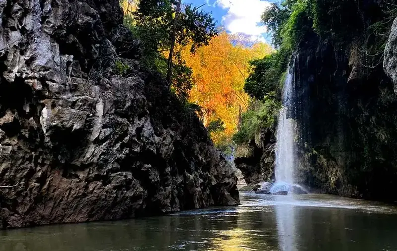
The defining image of Thi Lo Le Waterfall is its powerful stream dropping from a steep cliff of about 80 meters into the Mae Klong River below. The surrounding rock formations, gorge-like setting, and cave-like riverside cliffs create a wild and atmospheric scene. When travelers approach the waterfall by raft, the scale of the cliff and the sound of the falling water become increasingly impressive. This is not a waterfall designed for casual access; it is a place where the journey itself becomes part of the experience.
The name “Thi Lo Le” is commonly explained as a Karen-language name meaning “stone waterfall”. The meaning fits the landscape well, as the waterfall is surrounded by rock cliffs and boulders along the Mae Klong River. Unlike open waterfalls with wide pools and easy viewpoints, Thi Lo Le feels enclosed by forest and stone. Its beauty comes from the sense of discovery, remoteness, and raw natural power.
The journey usually begins in Umphang District, then continues along the Umphang–Palatha route toward Ban Palatha, a Karen community that remains closely connected with forest life and the river landscape. From there, travelers continue by inflatable raft along the Mae Klong River or follow authorized routes arranged by local operators. Because the route involves river travel, forest terrain, and protected-area regulations, visitors should not attempt the trip independently without experienced local guides.
Rafting along the Mae Klong River is one of the most important parts of the Thi Lo Le experience. The upper Mae Klong flows through quiet forest, rocky banks, and sections of water that change according to the season. Along the way, travelers may see dense rainforest, ferns, moss-covered rocks, large trees, and natural river scenery that feels far removed from urban tourism. The sound of water, birds, and the surrounding forest gives the trip a strong sense of immersion.
Most trips to Thi Lo Le Waterfall are not suitable for a one-day itinerary. Many travel programs require at least 2 days, sometimes more depending on the route, water level, season, and operator arrangements. Overnight camping along the route allows travelers to experience the forest more fully. Staying overnight in nature also requires discipline: visitors must keep the campsite clean, manage waste properly, follow guide instructions, and avoid disturbing wildlife or vegetation.
Thi Lo Le is best suited to travelers with an adventurous spirit and adequate physical readiness. The trip may involve road travel into remote areas, rafting, walking in natural terrain, exposure to rain or river water, and limited facilities. Travelers should prepare quick-dry clothing, non-slip trekking shoes or river shoes, waterproof bags, a flashlight, personal medication, rain protection, drinking water, and basic personal supplies. Good preparation makes the journey safer and more rewarding.
The surrounding forest is part of the wider western forest complex, one of Thailand’s most important ecological regions. This landscape supports diverse plant life, wildlife habitats, and headwater systems. For this reason, visiting Thi Lo Le should be understood as eco-travel rather than ordinary recreation. Travelers should avoid loud noise, never leave rubbish behind, never remove plants or stones, and never disturb wildlife. Every action matters in a sensitive natural area.
Older travel descriptions of the Thi Lo Le route sometimes mention elephant riding or elephant trails as part of the return journey. However, present-day travelers should always confirm the current travel format with licensed operators and the responsible authorities before departure. Routes, rules, and activities may change according to conservation measures, seasonal conditions, visitor safety, and animal welfare considerations. The safest and most responsible approach is to follow current local guidance rather than relying on outdated travel patterns.
The most suitable period for visiting Thi Lo Le is generally after the rainy season and into the early cool season, when the water level is appropriate for rafting and the weather is more stable. November to December is often considered a favorable period for rafting because the water is clearer and the river level is more manageable. Even so, river conditions can change quickly. Visitors should check weather, river levels, and access permission before committing to the trip.
For photographers, Thi Lo Le Waterfall offers exceptional natural composition: a tall cliff, falling water, dark rock surfaces, the Mae Klong River, dense forest, and a remote wilderness atmosphere. Camera equipment and mobile phones should be protected in waterproof bags because rafting and waterfall mist can easily cause damage. Travelers should avoid unsafe photo positions, slippery rocks, and cliff edges. The best photographs are those taken safely without disturbing the environment or the group.
Thi Lo Le is also a strong example of community-based eco-tourism. A trip to the waterfall usually involves local guides, rafting operators, guesthouses, restaurants, transport providers, and small businesses in Umphang. Spending locally helps circulate income within the community and gives local people a reason to protect the natural assets around them. Respectful tourism therefore supports both conservation and local livelihoods.
The route to Thi Lo Le should not be rushed. The value of the trip is not only the moment of seeing the waterfall, but also the gradual movement through mountain roads, Karen villages, river scenery, forest corridors, and overnight nature experiences. Each part of the journey adds meaning to the final destination. For travelers willing to slow down and observe carefully, the route itself becomes as memorable as the waterfall.
Compared with better-known waterfalls in Umphang such as Thi Lo Su, Thi Lo Le is quieter, deeper in the forest, and more challenging to reach. It is ideal for travelers who want a less crowded and more expedition-like experience. The trip requires more planning and readiness, but it offers the feeling of entering a truly natural landscape where forest, river, rock, and waterfall remain closely connected.
Travelers planning a visit should begin by contacting accommodations or experienced local operators in Umphang. They should ask about the current route status, season, water conditions, number of travel days, equipment requirements, permitted access, and safety measures. If traveling as a group, members should share any important health information with the guide in advance. Extra time should also be allowed for the Mae Sot–Umphang mountain road, which is long, winding, and requires careful driving.
The lasting impression of Thi Lo Le Waterfall comes from the feeling of entering nature gradually and respectfully. The journey passes through mountains, communities, river bends, forest shade, and protected wilderness before reaching the waterfall itself. This makes Thi Lo Le more than a scenic attraction. It is a meaningful nature journey that reveals the relationship between people, river, forest, and conservation.
Thi Lo Le Waterfall in Tak Province is therefore a destination for travelers who seek depth, adventure, and genuine natural beauty. The journey may be demanding, but the dramatic waterfall, the richness of the forest, the silence of the Mae Klong River, and the cultural context of the local communities make every moment worthwhile for those who travel with care and responsibility.
| Name | Thi Lo Le Waterfall / Thi Lo Re Waterfall |
| Location | Mae Lamung Subdistrict, Umphang District, Tak Province |
| Important Area | Located in the protected forest area of Umphang and connected with the eastern side of Thungyai Naresuan Wildlife Sanctuary and the Mae Klong River |
| Highlights | A remote forest waterfall beside the Mae Klong River, featuring high cliffs, rock gorges, cave-like formations, and a strong adventure atmosphere |
| Distinctive Features | A waterfall about 80 meters high, flowing from a steep cliff into the Mae Klong River amid rainforest and rock formations |
| Name Origin | “Thi Lo Le” is commonly explained as a Karen-language name meaning “stone waterfall” |
| Recommended Activities | Inflatable rafting, upper Mae Klong River adventure, forest trekking, overnight camping, photography, and eco-tourism |
| Travel Information | From Umphang District, follow the Umphang–Ban Palatha route for about 27 km, then continue by inflatable raft along the Mae Klong River or by authorized walking routes. Travelers should go with experienced local guides and operators. |
| Typical Trip Duration | Usually arranged as an adventure trip of at least 2 days, depending on season, water level, and route conditions |
| Recommended Season | After the rainy season to early cool season, especially when the water level is suitable for rafting, such as November–December |
| Current Status | A natural attraction inside a protected forest area. Access depends on official permission, season, water conditions, and route safety. |
| Open Days | Accessible depending on the travel season, water conditions, and permission from the responsible conservation authorities |
| Opening Hours | Visitors should follow authorized trip schedules and begin activities in the morning |
| Facilities | Travelers should prepare personal supplies in Umphang town and use local accommodations, restaurants, tour operators, and guides before entering the forest route |
| Caretaker / Local Authority | Umphang Wildlife Sanctuary and Thungyai Naresuan Wildlife Sanctuary East |
| Main Contact Number | Umphang Wildlife Sanctuary, Tel. 055-508780, 088-275272 / Thungyai Naresuan Wildlife Sanctuary East, Tel. 081-8859712 |
| Nearby Tourist Attractions | 1. Ban Palatha, about 27 km from Umphang town 2. Mae Klong River and Upper Mae Klong Rafting Route, on the same travel route 3. Thi Lo Su Waterfall, about 30–40 km from Umphang town on the main travel route 4. Thi Lo Cho Waterfall / Rain Waterfall, about 4 km from Umphang town 5. Doi Hua Mot, about 10 km from Umphang town |
| Nearby Restaurants | 1. Ban Khru San Umphang, about 27 km from Ban Palatha / about 4 km from Umphang town 2. Khrua Khon Ban Hao, about 27 km from Ban Palatha / about 4 km from Umphang town, Tel. 055-561207, 080-0394631 3. Khrua Pa Ni Umphang, about 27 km from Ban Palatha / about 4 km from Umphang town, Tel. 089-6763721 4. Cheewa Doi Umphang, about 27 km from Ban Palatha / about 4 km from Umphang town, Tel. 055-561176 5. Nong Kung Restaurant Umphang, about 27 km from Ban Palatha / about 4 km from Umphang town, Tel. 055-561067 |
| Nearby Accommodations | 1. Umphangburi Resort, about 27 km from Ban Palatha / about 4 km from Umphang town, Tel. 055-561576, 063-9894555 2. Thee Lor Su Riverside Resort, about 27 km from Ban Palatha / about 4 km from Umphang town, Tel. 089-8321455, 089-0165666 3. Ban Khru San Guesthouse, about 27 km from Ban Palatha / about 4 km from Umphang town 4. Umphang Country Hut, about 27 km from Ban Palatha / about 4 km from Umphang town 5. Umphang Riverside Resort, about 27 km from Ban Palatha / about 4 km from Umphang town |
Frequently Asked Questions (FAQ)
Q: Where is Thi Lo Le Waterfall located?
A: Thi Lo Le Waterfall is located in Mae Lamung Subdistrict, Umphang District, Tak Province, within a protected forest area connected with the eastern side of Thungyai Naresuan Wildlife Sanctuary and the Mae Klong River.
Q: How tall is Thi Lo Le Waterfall?
A: Thi Lo Le Waterfall is about 80 meters high, with water falling from a steep cliff into the Mae Klong River.
Q: What does the name Thi Lo Le mean?
A: The name “Thi Lo Le” is commonly explained as a Karen-language name meaning “stone waterfall”, matching the rocky cliff and boulder landscape around the waterfall.
Q: How many days are needed for a trip to Thi Lo Le Waterfall?
A: Travelers should generally plan for at least 2 days because the trip involves traveling from Umphang to Ban Palatha, rafting along the Mae Klong River, and possibly camping overnight.
Q: When is the best time to visit Thi Lo Le Waterfall?
A: The best period is generally after the rainy season and into the early cool season, especially when river conditions are suitable for rafting, such as November–December. Travelers should always check water levels and access permission before departure.
Q: Who is Thi Lo Le Waterfall suitable for?
A: It is suitable for nature lovers, adventure travelers, physically prepared visitors, and those who want a deeper forest experience in Umphang. It is not ideal for rushed trips or travelers uncomfortable with remote natural conditions.
Q: What should travelers prepare for Thi Lo Le Waterfall?
A: Travelers should prepare quick-dry clothing, trekking or non-slip shoes, waterproof bags, a flashlight, personal medication, rain protection, and should travel with experienced local guides or operators.
Q: Can travelers visit Thi Lo Le Waterfall independently?
A: Independent travel without a guide is not recommended because the waterfall is located deep inside a protected forest area and the route involves river travel, forest terrain, and official access permission.
 Category: ●Nature and Wildlife
 Group: ●Waterfalls
Last Update : 5 MonthAgo
 Last Update : 5 MonthAgo
 Click to Access the Navigation Map GPS
Thi Lo Le Waterfall Map
Recommend

 Art, Culture and Heritage
 Historical Sites and Monuments(2)
 Landmarks and Memorials(3)
 Art, Craft Centres, Tradition(6)
 Historic Homes and Cities(2)
 Educational Places
 Educational Gardens, Farm(2)
 Places of Worship
 Temple(22)
 Other Sacred Sites(9)
 Research and Development
 Royal Project(1)
 Suburban Living
 Village, Community(5)
 Local Market(3)
 National Parks and Marine Reserves(11)
 Mountain (Doi)(9)
 Dam, Reservoir, Lake(14)
Waterfalls(23)
Dam, Reservoir, Lake(14)
Waterfalls(23)
 Hot Springs(2)
 Caves(6)
 River, Canal(1)
 Bays and Beaches(1)
 Islands(1)
 Other natural attractions(1)
 Entertainment and Agricultural
 Farms, Parks and Ecotourism(5)
 Outdoor and Adventure Activities(4)
 Travel Articles, Recipes
 Travel Review, Food Review(1)


