
lovethailand home >North Travel Attractions >Chiang Mai Travel Attractions >Doi Lo >Santi Suk > Mae Wang National Park
TL;DR: Mae Wang National Park, open Daily in designated visitor areas, subject to park announcements and seasonal, hours 08:30–16:30 for general park services. Published sightseeing hours for Pha Chor.

Mae Wang National Park
Open Days: Daily in designated visitor areas, subject to park announcements and seasonal restrictions.
Opening Hours: 08:30–16:30 for general park services. Published sightseeing hours for Pha Chor are 08:00–16:00.
Mae Wang National Park, Chiang Mai Province, Thailand, is a protected natural area distinguished by its geological formations, forests, waterfalls and mountains. Located in southern Chiang Mai Province, the park extends across parts of Doi Lo, Chom Thong and Mae Wang districts. It covers approximately 74,766 rai, or 119.6256 square kilometers. Its most famous attraction is Pha Chor, an impressive formation of ancient sedimentary cliffs shaped by natural erosion into towering columns, layered walls and deep gullies. Other attractions include Mae Wang Waterfall, Pha Mon Waterfall, Tat Mok Waterfall, watershed forests and mountain routes that reveal the natural diversity of southern Chiang Mai.
Mae Wang National Park is particularly interesting because several distinctive natural environments can be experienced within a single protected landscape. The park includes high forested mountains as well as geological formations that expose ancient layers of sediment. Near Pha Chor, hills and drainage channels have been shaped by erosion over long periods. At higher elevations, cooler conditions support important watershed forests. These differences give Mae Wang a distinctive character that extends beyond any single viewpoint or waterfall.
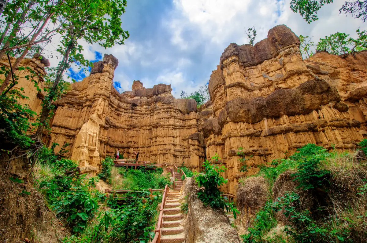
Pha Chor is the attraction most closely associated with Mae Wang National Park. Its yellowish-brown cliffs reveal layers of sediment deposited at different times. The layers vary in hardness, composition and texture, allowing rainfall and erosion to create different shapes as they gradually remove softer material. Some sections resemble tall earth pillars, while others form broad sediment walls displaying intersecting horizontal and vertical patterns. When sunlight illuminates these surfaces, the landscape takes on a particularly striking appearance.
The significance of Mae Wang National Park extends beyond its scenic attractions. The protected forests contribute to the watersheds of the Mae Wang, Mae Chaem and Mae Tuen rivers, which connect with the wider Ping River system. Forests along the Thanon Thongchai Range absorb rainfall, maintain moisture and provide habitats for diverse wildlife. Conserving the park is therefore important both for the mountain environment and for communities living downstream.
History of Mae Wang National Park is associated with the conservation of several national reserved forests in Chiang Mai Province. On March 29, 2001, Ob Khan National Park submitted information concerning nearby forest areas, including the Mae Khan–Mae Wang, Chom Thong, Mae Chaem and Samoeng forests. These landscapes were recognized for their natural condition, biodiversity, watershed functions and scenic attractions, making them suitable for consideration as national park land.
On June 12, 2001, the Royal Forest Department appointed a working group to conduct preliminary surveys. The assessments examined forest conditions, geography, potential boundaries and the suitability of the land for national park designation. Personnel associated with Ob Khan, Doi Inthanon and Si Lanna national parks participated in gathering information on the natural resources of southern and western Chiang Mai.
The surveys led to consideration of forest areas extending across Mae Chaem, Mae Wang, Chom Thong and Doi Lo districts. The establishment process required evaluation of forest resources, watershed connections and the surrounding landscape before the legally protected area could be determined. These assessments helped create a foundation for coordinated forest management.
Mae Wang National Park was formally established on November 20, 2009, becoming Thailand's 112th national park. Its designation was made under the Royal Decree establishing a national park within parts of the Chom Thong, Mae Khan and Mae Wang forests of Chiang Mai Province, published in the Royal Gazette, Volume 126, Part 86 A. This designation gave the area legal protection and placed its natural resources under national park management.
The designated park extends across Santi Suk, Yang Khram and Doi Lo subdistricts in Doi Lo District; Ban Luang and Khuang Pao subdistricts in Chom Thong District; and Thung Pi Subdistrict in Mae Wang District. These areas include natural environments ranging from hills and dry dipterocarp woodland to high-altitude forests. The result is a protected landscape containing several distinct ecosystems under a common management framework.
Official Status of Mae Wang National Park is that of a fully designated national park rather than a proposed park under establishment. It is managed by Thailand's Department of National Parks, Wildlife and Plant Conservation. The park headquarters is located in Santi Suk Subdistrict, Doi Lo District, Chiang Mai Province. Its responsibilities include forest conservation, wildfire prevention, ranger patrols, wildlife protection, management of tourism attractions and public visitor services.
Geography of Mae Wang National Park is dominated by the rugged Thanon Thongchai mountain range, which extends generally north to south. Elevations range from approximately 400 to 1,909 meters above sea level. This considerable variation produces mountain ridges, valleys, steep slopes, streams and narrow areas of lower ground. Some locations are relatively dry during part of the year, while higher elevations retain greater moisture and support different plant communities.
Doi Pha Tang is the highest mountain within Mae Wang National Park, rising approximately 1,909 meters above sea level. Its exposed upper areas experience cooler temperatures and strong winds. The landscape is connected with the broader high mountain region near Doi Inthanon, giving it ecological importance as part of the upland watershed environment.
Other significant mountains include Doi Pong Samit at approximately 1,547 meters, Doi Hin Luang at 1,518 meters, Doi Huai Luang at 1,415 meters, Doi Mae Lip at 1,311 meters, Doi Khun Mae Sa at 1,251 meters, Doi Pha Lai at 1,245 meters and Doi No at 1,120 meters above sea level. These mountains contribute to the varied topography and support different forest and climatic conditions.
Elevation strongly influences local temperature and humidity. Lower hills experience warmer conditions and vegetation adapted to pronounced dry seasons, while higher elevations are cooler and generally more humid. As a result, forest types change across the landscape, including mixed deciduous forest, dry dipterocarp forest, hill evergreen forest and pine forest.
Climate of Mae Wang National Park is influenced by the southwest monsoon, which brings moisture and rain to northern Thailand. The hot season generally extends from March through May, the rainy season from June through November, and the cool season from December through February. Local weather varies with altitude and terrain, with mountain areas typically cooler than the lower valleys.
Published park climate information gives an annual average temperature of approximately 20°C. During the cool season, average temperatures are around 15–17°C, with average minimum values of approximately 10–14°C. Annual rainfall is approximately 2,000–2,100 millimeters. This rainfall is essential for forest growth and the waterways originating in the mountains.
Pha Chor in Mae Wang National Park is the park's most celebrated geological attraction. Located in the Yang Khram and neighboring Santi Suk area of Doi Lo District, it consists of large ancient sedimentary cliffs, natural earth pillars and clearly visible horizontal layers. Some formations reach approximately 30 meters in height. Their unusual appearance was created through long-term environmental changes and erosion that exposed the layered structure of the former river sediments.
The formation of Pha Chor is closely connected with the ancient Ping River system. The area once received deposits of gravel, sand and soil transported by flowing water. These materials accumulated in layers over time. Later changes in the landscape and river course left the deposits elevated and exposed. Rainfall and erosion subsequently removed softer material, producing the dramatic columns and cliffs visible today.
Important evidence of the former river environment includes rounded pebbles and sedimentary layers containing different particle sizes. Rounded stones develop as they move and collide in running water over extended periods. Finding them within elevated sediment deposits helps explain the historical movement of watercourses and changes in the landscape.
The yellowish-brown cliffs of Pha Chor contain layers deposited at different times. Some are relatively compact and resistant to erosion, while others are more easily removed by rainfall. As rainwater repeatedly flows across the exposed surfaces, small channels gradually deepen into gullies and leave behind narrow pillars of remaining sediment.
The Earth Pillars and Sedimentary Cliffs vary in shape according to material hardness and the direction of water erosion. Some pillars have wider upper sections, while other areas resemble enormous walls marked by horizontal strata. Looking upward from the base reveals the height and texture of the formations. Elevated viewpoints allow visitors to appreciate the arrangement of the pillars and the surrounding terrain.
The color and appearance of Pha Chor change with sunlight. Soft morning light gives the sediment warm tones, while stronger midday illumination reveals the texture of the vertical gullies. Passing clouds create shifting shadows that emphasize the layers and irregular forms. These changes in light are part of the visual experience of exploring the site.
One of the most impressive aspects of Pha Chor is that visitors can observe the sedimentary formations from relatively close range while remaining on designated walkways. Rather than viewing the site only from a distant panorama, they can see soil, rounded stones and erosion patterns in the landscape itself. The formations demonstrate how gradual natural processes can eventually create enormous and complex landforms.
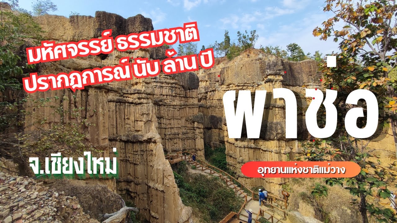
The Pha Chor Nature Study Trail connects the visitor parking area with the main cliffs and earth pillars. The route passes forested terrain, natural drainage features, steps and constructed walking sections. Its educational value comes from the opportunity to observe gradual changes in soil, surface materials and the surrounding landscape before reaching the main geological formation.
Parts of the trail ascend and descend uneven terrain. Suitable footwear with good traction is important, especially after rainfall when the ground can become slippery. Visitors should also prepare for direct sunlight because the exposed cliff area provides less shade than the forested sections of the route.
The trail provides opportunities to observe plants adapted to relatively dry soil, shrubs growing along the route and channels created by runoff. Comparing vegetated ground with exposed sedimentary walls helps explain how roots and plant cover influence erosion and soil stability.
Conservation of Pha Chor is essential because the cliffs and pillars developed through sedimentation and erosion over very long periods. Some surfaces are fragile and can be damaged by climbing or forceful contact. Leaving designated paths can also damage vegetation and accelerate soil loss. Visitors must therefore maintain appropriate distances from the formations and follow the park's safety boundaries.
Pha Chor is valuable for both tourism and education. Its visible layers offer opportunities to study sedimentation, former river systems, weathering and erosion. Schools, students and other visitors can connect geological concepts with physical evidence in the natural environment.
Mae Wang Waterfall is another important attraction within the national park. Located in the Mae Wang area, it is a single-tier waterfall approximately 20 meters high and 10 meters wide. It flows throughout the year and forms part of the Mae Wang watershed. The surrounding forest provides a shaded environment quite different from Pha Chor's exposed sedimentary cliffs.
Mae Wang Waterfall is attractive because water flows down a rocky face into the pool below. Its volume changes with rainfall and seasonal conditions. Continuous rain can increase the flow, while drier periods may reduce the volume. Forests around the stream provide shade and help retain moisture in the local environment.
Visiting Mae Wang Waterfall offers an experience quite different from exploring Pha Chor. The waterfall environment is wetter, and visitors can observe relationships among streams, forest vegetation and small freshwater organisms. Swimming should take place only in designated safe areas, away from slippery rocks and strong currents.
Pha Mon Waterfall is located in Mae Win Subdistrict, Mae Wang District. It is a three-tier waterfall approximately 30 meters high and 25 meters wide. The waterfall flows throughout the year and contributes to the Mae Wang watershed. Its stepped rocky terrain creates several distinct sections of cascading water.
The forest around Pha Mon Waterfall helps maintain humidity and provides feeding environments for organisms associated with mountain streams. Flowing water produces sound and moisture near the falls. The area is therefore important for understanding stream ecology and seasonal changes in the watershed.
Tat Mok Waterfall is located in Yang Khram Subdistrict, Doi Lo District. It consists of a single drop approximately 15 meters high and 10 meters wide. The stream flows throughout the year and belongs to the Mae Tuen watershed. The waterfall is another example of the relationships among mountain terrain, forest cover and freshwater systems in Mae Wang National Park.
Waterfalls within forests provide moist habitats for organisms dependent on streams and wet environments. Plants and aquatic animals may occupy rock crevices and stream margins. Preserving water quality and preventing litter helps maintain environmental conditions that extend downstream.
Other Waterfalls and Natural Waterways in Mae Wang National Park include Khun Puai, Mueang Ang, Mae Puai, Pla Duk Daeng, Pong Noi and Pong Samit waterfalls. These attractions are distributed across the park's mountains and stream systems. Access conditions differ by location, and some are remote from the main visitor service area and require permission from park authorities.
The presence of many waterfalls reflects the park's rugged mountainous geography. Rainwater descends from ridges through numerous channels, and changes in elevation cause water to flow across rocks and cliffs. These waterfalls belong to the wider processes of freshwater circulation and landscape erosion.
Doi Pha Tang Within Mae Wang National Park rises approximately 1,909 meters above sea level in the Mae Win area. It forms part of the extensive highland landscape of southern Chiang Mai. Cooler conditions, strong winds and exposed mountain terrain distinguish its summit environment from the valleys. Its forests also contribute to watershed conservation.
Doi Pha Tang in Mae Wang National Park should not be confused with the mountain destination of the same name in Wiang Kaen District, Chiang Rai Province. Although the names are identical, the places are in different provinces and belong to different mountain landscapes. Their travel routes and administrative arrangements are entirely separate.
The Mae Chaem Scenic Route passes through mountainous and forested areas connecting the Mae Wang region with Mae Chaem. The journey offers views of ridgelines, valleys and different forest types at various elevations. Cooler conditions at higher points are similar in some respects to the uplands around Doi Inthanon National Park.
The scenic route allows travelers to observe transitions from lower farming communities toward higher mountain forests. Such journeys demonstrate how vegetation and settlement patterns change with topography. Driving requires care on winding roads, particularly during rain and fog.
Kio Suea Ten and Other Highland Features are among the natural attractions listed by the Department of National Parks for Mae Wang. These landscapes are associated with ridges and upland terrain. Access depends on road and trail conditions and the park's current management arrangements.
Pong Cho Reservoir is another natural-area attraction listed within the park. The reservoir is associated with water storage and the surrounding mountain landscape. In authorized visitor areas, it provides opportunities to observe the relationship between freshwater and forest scenery.
Pha Daeng appears among the park's attractions in the historical category. Its inclusion shows that the wider landscape also contains places connected with human activity and local history. Access to remote sites depends on available routes and park authorization.
Mixed Deciduous Forest occurs at elevations of approximately 400–1,000 meters above sea level. It includes teak, crape myrtle, rosewood, red hardwood, krabok, so and various bamboo species. Many trees shed their leaves during dry months and return to greener growth when rainfall increases.
Mixed deciduous forests play an important role in nutrient cycling. Fallen leaves break down into organic matter, gradually enriching the soil. Trees also provide food and shelter for many forest animals. This forest type is therefore an important ecological environment with pronounced seasonal changes.
Dry Dipterocarp Forest occurs mainly on relatively dry hills and ridges at approximately 400–900 meters above sea level. Important trees include teng, rang, hiang, phluang and phayom. Many species are adapted to dry conditions and soils with limited moisture, creating woodland structures different from those of more humid evergreen forests.
During the dry season, fallen leaves accumulate on the forest floor, increasing the importance of wildfire prevention. Severe or excessively frequent fires can damage trees, soil organisms and wildlife habitats. Ranger patrols and cooperation with surrounding communities are therefore important elements of forest management.
Pine Forest occurs in parts of the park at elevations of approximately 900–1,500 meters. Two-needle and three-needle pines are characteristic trees, growing alongside species such as wild jambolan, thalo and several kinds of oak. These forests have a different appearance from the mixed deciduous woodland at lower elevations.
Pine forests contribute to botanical diversity and the visual character of the uplands. Their needle-like leaves, growth habits and associated ground vegetation reflect adaptation to highland conditions. The forest structure varies according to canopy density, soil and exposure.
Hill Evergreen Forest occurs mainly at elevations above approximately 1,000 meters. Representative plants include wild magnolia, cinnamon, forest saraphi, kamlang suea khrong and various oak species. These forests help retain moisture on the higher mountains and provide habitats for organisms adapted to conditions different from those of lower, drier forests.
The continuity of hill evergreen forests is important for watershed protection. Vegetation slows rainfall runoff, while root systems help stabilize soil on steep slopes. Healthy forest cover consequently supports water quality and reduces the loss of surface soil.
Wildlife in Mae Wang National Park varies according to forest habitat and elevation. The Department of National Parks lists mammals including barking deer, wild boar, rhesus macaques, white-handed gibbons, civets, yellow-throated martens, brush-tailed porcupines, hares and red-bellied squirrels. Different species use the forests for feeding, resting, shelter and reproduction.
Connected habitats allow wildlife to move between feeding grounds and refuge areas. Habitat fragmentation and human disturbance can influence animal behavior, making protected-area management important for conserving wildlife beyond the main tourism zones.
Recorded birds include crested serpent eagles, red junglefowl, barred-backed pheasants, barred buttonquails, emerald doves, greater coucals, Asian barred owlets, red-headed trogons, Oriental pied hornbills, barbets and several woodpeckers. The bird diversity reflects a variety of habitats ranging from open woodland to more densely vegetated forests.
Reptiles and amphibians recorded in the park include big-headed turtles, elongated tortoises, flying lizards, monitor lizards, reticulated pythons, banded kraits, king cobras, stream frogs, tree frogs and common toads. These animals play important ecological roles. Visitors should not attempt to approach, touch or disturb wildlife, particularly venomous or potentially defensive species.
The Watersheds of Mae Wang National Park are associated with three important rivers: the Mae Chaem, Mae Wang and Mae Tuen. These waterways connect with the Ping River system. Smaller mountain streams gradually join larger watercourses as they descend toward the lowlands, supporting forests and surrounding communities.
The Mae Wang River is particularly important to Mae Wang District and nearby communities because of its relationship with agriculture, freshwater use and local tourism. Forest conservation helps maintain water quality, reduce sediment movement and support freshwater ecosystems throughout the wider watershed.
Bamboo Rafting on the Mae Wang River is a well-known activity in Mae Wang District. Most familiar rafting services operate along river sections associated with local communities and independent tourism businesses. These should be distinguished from the visitor services inside Mae Wang National Park and the Pha Chor geological attraction.
Bamboo rafts have historical associations with river-based life in northern Thailand and are now used for scenic recreation. Rafting allows visitors to observe trees, communities and riverbanks from water level. Activities require experienced raft operators, appropriate safety measures and careful evaluation of water levels and currents.
Connecting Mae Wang National Park with Local Communities brings visitors into Doi Lo, Chom Thong and Mae Wang districts, where farming communities, villages, restaurants and accommodation providers are distributed along the main roads. Regional travel can therefore combine natural attractions with the everyday landscapes and livelihoods of southern Chiang Mai.
Doi Lo District is particularly relevant to a visit to Pha Chor because the park headquarters and main access roads are located in this area. Communities along the route engage in agriculture and tourism services. The journey illustrates the relationship between cultivated land, local settlements and protected forests.
Chom Thong District is another important part of the region and a major access point to attractions in southern Chiang Mai. Significant destinations include Wat Phra That Si Chom Thong Worawihan and routes toward Doi Inthanon National Park. Visitors can therefore connect the geological scenery of Pha Chor with religious heritage and the history of Lanna communities.
Wat Phra That Si Chom Thong Worawihan is an important Buddhist temple in Chom Thong District. Its sacred relic is deeply respected by Buddhist communities and associated with Lanna religious traditions. The temple serves as a center of worship and community activities. Combining the temple with Pha Chor provides experiences of both natural and cultural heritage.
Doi Inthanon National Park is another important protected area in the highlands of southern Chiang Mai. Its mountain forests contribute to watershed conservation, but it is administratively separate from Mae Wang National Park. The two parks have different visitor areas, roads and entry arrangements, so travel between them should be planned according to actual routes and available time.
Chiang Mai Grand Canyon and Other Geological Landscapes provide opportunities to compare different types of dramatic terrain. However, attractions developed from excavated pits or modified land have a different origin from Pha Chor, whose cliffs result from ancient sediment deposition followed by natural erosion. Similar visual appearances do not necessarily indicate similar geological histories.
Winter in Mae Wang National Park brings cooler temperatures to higher elevations and can be comfortable for outdoor exploration. Pha Chor is generally more pleasant when the sun is less intense, while elevated forests are cooler, especially in the morning and at night. Visitors should prepare differently for lowland geological trails and high mountain areas.
Winter is also a period of changing forest colors. Some deciduous trees lose their leaves, adding yellow and brown tones to the landscape, while humid hill evergreen forests retain much of their green appearance. These contrasts make the ecological differences among the park's forest types more visible.
The Rainy Season in Mae Wang National Park brings lush forests and increased waterfall flows. Rainfall supports plant growth and freshwater systems, but natural trails can become slippery and streams can rise rapidly. Visits to waterfalls and Pha Chor must therefore follow safety restrictions established by park personnel during periods of heavy rainfall.
Pha Chor is particularly sensitive to water erosion because some sedimentary layers are relatively fragile. Heavy rain may cause material to detach or runoff to flow through gullies. Visitors must stay within protected walkways and respect closed sections near unstable surfaces.
Summer in Mae Wang National Park can bring hotter conditions to the exposed Pha Chor area. Some dry dipterocarp and mixed deciduous forests contain large quantities of fallen leaves, increasing the importance of wildfire prevention. Tourism management during this season must consider heat, visitor safety and protection of the surrounding forests.
Wildfire Prevention is essential, especially in forest types where dry leaves accumulate seasonally. Wildfires can damage vegetation, wildlife habitats, air quality and visibility along access roads. Ranger patrols and early detection therefore play important roles in conservation and community safety.
Camping at Mae Wang National Park is supported through the Mae Wang Camping Ground listed in the Department of National Parks' reservation system. The camping area is associated with the park headquarters service zone. Overnight visitors must comply with site rules covering cleanliness, access and safety.
Camping provides time to experience the surrounding landscape without rushing back to the city. Appropriate tents, bedding and weather protection are important. Fires must not be lit outside authorized places, and camping should be confined to areas approved by park authorities.
Visitor Facilities at Mae Wang National Park include the park headquarters, visitor information services and the designated camping area. At Pha Chor, established paths and viewpoints help visitors appreciate the formations without walking freely across fragile ground. Facilities are managed according to the characteristics and needs of each visitor zone.
Mae Wang National Park Entrance Fees are THB 20 for Thai adults and THB 10 for Thai children. Foreign adults pay THB 100 and foreign children THB 50. These are national park admission charges and are separate from services offered by independent tourism operators, including rafting or equipment rental outside the park.
Getting to Mae Wang National Park from Chiang Mai City generally involves following Highway 108 south through Hang Dong and San Pa Tong toward Doi Lo District. The junction with Road 2069 near Santi Suk is approximately 45 kilometers south of Chiang Mai city, after which the route continues along local roads toward the national park or Pha Chor.
The access road to Pha Chor branches off before reaching the main park entrance, approximately 2.3 kilometers from the headquarters access point. Following the park's road signs helps distinguish the geological attraction from the main administrative area. Parts of the route pass agricultural communities and hills, so drivers should remain attentive to bends and local traffic.
Getting to Pha Chor is possible by private car or motorcycle along authorized roads. From the designated parking area, visitors continue on foot along the nature study trail. Vehicles do not travel directly to the base of the earth pillars because the attraction is accessed through managed pathways designed to protect the formations and visitors.
The Tourism Authority of Thailand publishes sightseeing hours of 08:00–16:00 for Pha Chor, while general park service hours are 08:30–16:30. Distinguishing these schedules is important because visiting the cliffs involves walking, and the geological trail is not suited to late-evening exploration.
Getting to Mae Wang Waterfall and Other Natural Attractions involves routes different from those used to reach Pha Chor. The park's attractions are distributed across several districts and mountain areas. Mae Wang Waterfall is approached through Mae Wang District, while highland attractions require travel on mountain routes. Arranging destinations by location helps reduce unnecessary backtracking.
Safety at Pha Chor begins with remaining on the designated trails, stairs and viewpoints. Visitors must not climb the cliffs or stand beneath unstable sections. Some sediment surfaces are less durable than solid rock and can be damaged by erosion. Keeping a safe distance reduces risks from slipping, falling or dislodged material.
Walking during hot weather requires adequate drinking water and suitable clothing. Some trail sections receive direct sun and offer limited shade. Visitors with mobility limitations should consider the stairs and uneven ground between the parking area and the cliffs.
Waterfall Safety is also important, particularly after heavy rainfall when currents can become stronger and rocks slippery. Swimming must be limited to authorized areas, and visitors should avoid approaching dangerous drops or fast-flowing channels.
Rules for Visiting Mae Wang National Park include taking rubbish away, not removing plants or flowers, never feeding wildlife and avoiding fires outside permitted areas. Visitors must use designated paths and respect closures because forests and sedimentary cliffs can be damaged by inappropriate activity.
Any wildlife encountered during a visit should be observed from a safe distance. Animals may defend themselves when threatened, and food waste can alter their behavior. Avoiding excessive noise and keeping the environment clean help preserve natural habitats.
Photography at Pha Chor is particularly rewarding because of the dramatic earth pillars, layered sediment cliffs and changing patterns of light and shadow. Designated viewpoints provide opportunities to photograph different perspectives without approaching or touching fragile formations.
Photographs taken at different times reveal how sunlight changes the appearance of the cliffs. Seasonal vegetation and moisture can also affect the surrounding colors. These observations provide another way to understand the relationship between weather and the landscape.
Family Visits to Mae Wang National Park can focus on attractions suited to each person's mobility. Pha Chor offers a geological learning experience along walking trails and stairs, while the park headquarters provides general visitor services and camping facilities. Waterfalls allow visitors to enjoy freshwater scenery where access and safety arrangements permit.
Children and students can learn about river sedimentation, soil layers, erosion and the differences between rocks and soil. Observing Pha Chor directly demonstrates that landscapes are continually changing, even when geological processes take far longer than a human lifetime.
Mae Wang National Park's Importance to Surrounding Communities lies in conserving forests and watersheds relevant to Doi Lo, Chom Thong and Mae Wang districts. Forests contribute to freshwater systems, while tourism supports local restaurants, accommodation and transport services. Protected-area management is therefore connected with both environmental conservation and community activities.
The park also provides opportunities for local environmental education. Pha Chor is an accessible example of geological evidence that can be understood through direct observation. Having an important natural learning site near communities contributes to awareness of long-term conservation.
Mae Wang National Park in Chiang Mai Province is significant because it brings together several types of natural heritage. Its attractions range from the remarkable ancient sedimentary cliffs of Pha Chor to Mae Wang, Pha Mon and Tat Mok waterfalls, the high mountain of Doi Pha Tang and the watershed forests of the Thanon Thongchai Range. Visiting the park reveals the relationships among geological processes, forests, freshwater and communities in southern Chiang Mai.
What most clearly distinguishes Mae Wang National Park is the visible evidence of landscape change at Pha Chor. At the same time, its mountains and forests continue to protect biodiversity and water resources. The preservation of these natural features and the careful management of visitor access make Mae Wang an important natural heritage destination in Chiang Mai Province.
| Place Name | Mae Wang National Park, Chiang Mai, Thailand |
| Headquarters Address | Moo 7, Santi Suk Subdistrict, Doi Lo District, Chiang Mai Province 50160, Thailand |
| Geographical Coverage | Parts of Doi Lo, Chom Thong and Mae Wang Districts, Chiang Mai Province |
| Legal Status | Officially Established National Park |
| Establishment Date | November 20, 2009 |
| National Park Number | 112th National Park of Thailand |
| Area | 74,766 rai, approximately 119.6256 sq km |
| Managing Authority | Department of National Parks, Wildlife and Plant Conservation, Thailand |
| Park Contact Number | +66 82 765 8524 |
| Tourism Authority Contact Number | +66 53 106 759 |
| Open Days | Daily in Designated Visitor Areas |
| General Park Hours | 08:30–16:30 |
| Pha Chor Sightseeing Hours | 08:00–16:00 according to published attraction information |
| Thai Visitor Admission Fee | Adult THB 20; Child THB 10 per person |
| Foreign Visitor Admission Fee | Adult THB 100; Child THB 50 per person |
| Landscape | Thanon Thongchai Mountain Range, Valleys, Waterfalls, Watershed Forests and Ancient Sedimentary Cliffs |
| Elevation | Approximately 400–1,909 meters above sea level |
| Highest Mountain | Doi Pha Tang, approximately 1,909 meters |
| Forest Types | Mixed Deciduous, Dry Dipterocarp, Mixed Dry Dipterocarp, Pine and Hill Evergreen Forests |
| Major Watersheds | Mae Chaem, Mae Wang and Mae Tuen Rivers, connected to the Ping River system |
| Main Highlight | Pha Chor, ancient sedimentary cliffs and natural earth pillars reaching approximately 30 meters in height |
| Main Visitor Zones | 1. Mae Wang National Park Headquarters 2. Pha Chor Nature Study Trail 3. Pha Chor Cliff and Earth Pillar Viewpoints 4. Mae Wang Camping Ground 5. Mae Wang and Pha Mon Waterfall Areas 6. Watershed Forests and Highland Areas 7. Mae Chaem Scenic Route |
| Attractions Within the Park | Pha Chor, Doi Pha Tang, Kio Suea Ten, Mae Wang Waterfall, Pha Mon Waterfall, Tat Mok Waterfall, Khun Puai Waterfall, Mueang Ang Waterfall, Mae Puai Waterfall, Pla Duk Daeng Waterfall, Pong Noi Waterfall, Pong Samit Waterfall, Pong Cho Reservoir, Pha Daeng and Mae Chaem Scenic Route |
| Camping | Mae Wang Camping Ground, within the Park Headquarters Service Zone, subject to current availability |
| Visitor Facilities | Park Headquarters, Visitor Information, Parking, Nature Study Paths and Camping Ground |
| Getting There from Chiang Mai | Take Highway 108 south approximately 45 km toward Santi Suk, then follow Road 2069. The Pha Chor access junction is approximately 2.3 km before the main park entrance. |
| Nearby and Connected Attractions | 1. Pha Chor – Inside the Park 2. Tat Mok Waterfall – Inside the Park 3. Mae Wang Waterfall – Inside the Park 4. Pha Mon Waterfall – Inside the Park 5. Doi Pha Tang – Inside the Park 6. Wat Phra That Si Chom Thong Worawihan – Chom Thong District 7. Doi Inthanon National Park – Chom Thong District 8. Pong Noi Waterfall – Approximately 32 km from Pha Chor according to the tourism listing |
| Restaurants Along Nearby Travel Routes | 1. Krua Doi Lo Restaurant – Approximately 18 km from Pha Chor, Tel. +66 81 026 4699 2. Huen Doi Lo Café and Homestay – Approximately 18 km, Tel. +66 83 240 2611 3. Mae Wang Mountain View – Approximately 28 km, Tel. +66 93 386 2638 4. Ma Mueang Win – Approximately 30 km, Tel. +66 81 035 5395 5. Inthanon Highland – Approximately 52 km, Tel. +66 53 802 222 ext. 4 |
| Accommodation Along Nearby Travel Routes | 1. Pha Chor Hill Resort – Approximately 6 km from Pha Chor, Tel. +66 62 428 9153 2. De Oeng Boutique, Doi Lo – Approximately 18 km, Tel. +66 61 316 0822 3. Green Tree Resort, Doi Lo – Approximately 18 km, Tel. +66 63 383 3183 4. Baan Suan Inthanon Resort – Approximately 45 km, Tel. +66 86 429 1642 5. Doi In View Resort – Approximately 48 km, Tel. +66 53 033 567 6. Baan Pornsri Resort – Approximately 50 km, Tel. +66 65 168 5624 |
| Park Reservation Website | https://booking.dnp.go.th/parksdetail.php?id=116 |
Frequently Asked Questions (FAQ)
Q: Where is Mae Wang National Park located?
A: Mae Wang National Park is located in southern Chiang Mai Province, covering parts of Doi Lo, Chom Thong and Mae Wang districts. Its headquarters is in Santi Suk Subdistrict, Doi Lo District.
Q: What are the opening hours and entrance fees?
A: General park service hours are 08:30–16:30. Admission is THB 20 for Thai adults, THB 10 for Thai children, THB 100 for foreign adults and THB 50 for foreign children.
Q: How was Pha Chor formed?
A: Pha Chor developed from gravel, sand and soil deposited by the ancient Ping River system. Later landscape changes and prolonged erosion by rainfall created its distinctive earth pillars, cliffs and deep gullies.
Q: How high are the Pha Chor formations?
A: Some of the sedimentary cliffs and earth pillars reach approximately 30 meters in height. Their yellowish-brown surfaces display layers shaped by erosion.
Q: When was Mae Wang National Park established?
A: Mae Wang National Park was established on November 20, 2009, as Thailand's 112th national park. It covers 74,766 rai.
Q: Which waterfalls are found in Mae Wang National Park?
A: Important waterfalls include Mae Wang, Pha Mon, Tat Mok, Khun Puai, Mueang Ang, Mae Puai, Pla Duk Daeng, Pong Noi and Pong Samit. Access depends on trail conditions and park management.
Q: Is camping available at Mae Wang National Park?
A: The park has a designated Mae Wang Camping Ground near its headquarters, listed in the Department of National Parks' reservation system. Overnight stays are subject to current opening arrangements and park regulations.
Q: How do visitors reach Pha Chor from Chiang Mai?
A: Follow Highway 108 south toward Doi Lo District, turn onto Road 2069 toward Mae Wang National Park, and take the signed access road to Pha Chor. Visitors then walk from the designated parking area along the nature study trail.
 Category: ●Nature and Wildlife
 Group: ●National Parks and Marine Reserves
Last Update : 2 WeekAgo
 Last Update : 2 WeekAgo
 Click to Access the Navigation Map GPS
Mae Wang National Park Map
Recommend

 Art, Culture and Heritage
 Historical Sites and Monuments(8)
 Landmarks and Memorials(5)
 Royal Palace(2)
 Art, Craft Centres, Tradition(43)
 Museums(24)
 Educational Places
 Museum for Study(2)
 Educational Gardens, Farm(5)
 Training Center(1)
 Places of Worship
 Temple(79)
 Mosque(2)
 Other Sacred Sites(17)
 Research and Development
 Royal Project(45)
 Suburban Living
 Village, Community(41)
 Local Market(14)
National Parks and Marine Reserves(18)
 Mountain (Doi)(21)
 Dam, Reservoir, Lake(26)
 Waterfalls(43)
 Hot Springs(12)
 Caves(11)
 River, Canal(6)
 Other natural attractions(14)
 Entertainment and Agricultural
 Zoos and Aquariums(3)
 Animal camps and shows(3)
 Stadium(1)
 Farms, Parks and Ecotourism(19)
 Waterpark(2)
 Theater(1)
 Outdoor and Adventure Activities(10)
 Shopping
 Shopping and Night Market(6)
 Restaurant
 Michelin Star(1)
 Michelin Guide(23)
 Call Customer Service in Tourism
 Call Customer Service in Tourism(1)
 Travel Articles, Recipes
 Travel Review, Food Review(24)
 Food Menu, North Recipes(30)
 Thai Desserts, North Recipes(17)


