
lovethailand home >South Travel Attractions >Krabi Travel Attractions >Koh Lanta >Koh Lanta Yai > Mu Ko Lanta National Park
TL;DR: Mu Ko Lanta National Park, Krabi attractions : Nature and Wildlife, National Parks and Marine Reserves.

Mu Ko Lanta National Park
Open Days: Daily for the Laem Tanod headquarters area when there is no temporary closure notice; Ko Rok, Ko Haa, Hin Daeng-Hin Muang, and offshore marine areas operate seasonally
Opening Hours: 08.30 - 16.30
Mu Ko Lanta National Park is a major marine national park in Krabi Province, covering Ko Lanta Yai, Ko Lanta Noi, Ko Talabeng, Ko Rok, Ko Haa, Ko Ngai, and surrounding Andaman Sea islands. The protected area covers about 134 square kilometers, or approximately 83,750 rai. Its best-known mainland-accessible attraction is Laem Tanod at the southern tip of Ko Lanta Yai, where the park headquarters, white lighthouse, beaches, rocky shore, viewpoint, camping area, and nature trail are located. Offshore highlights include Ko Rok, Ko Haa, Ko Ngai, Hin Daeng, and Hin Muang, which are known for clear water, coral reefs, snorkeling, and diving during the open marine season.
Mu Ko Lanta National Park is located in Ko Lanta District, Krabi Province, and is one of the most important marine protected areas in the southern Andaman Sea. The park includes large islands, small islands, beaches, coastal forest, mangrove forest, coral reefs, diving sites, and offshore marine habitats. While many travelers know Koh Lanta for its long beaches, quiet resorts, and relaxed island atmosphere, the national park reveals a broader ecological identity: Koh Lanta is not only a beach destination, but also part of a wider protected seascape with islands, reefs, wildlife, coastal culture, and fragile marine ecosystems.
The most accessible part of the park is Laem Tanod, located at the southern tip of Ko Lanta Yai. This is where the park headquarters, visitor area, white lighthouse, viewpoint, beach, rocky shore, campground, and short nature trails are found. Visitors can reach this area by road from Sala Dan, Khlong Dao Beach, Long Beach, Khlong Khong Beach, Khlong Nin Beach, Lanta Old Town, or other parts of Ko Lanta Yai. For many travelers, Laem Tanod is the essential first stop because it provides the easiest way to experience the national park without joining an offshore boat trip.
The landscape of Mu Ko Lanta National Park is diverse. On Ko Lanta Yai, the park protects forested terrain, coastal slopes, beaches, and headlands. Around the offshore islands, it protects limestone and rocky islands, white-sand beaches, shallow reefs, deep-water dive sites, and marine habitats. Major areas associated with the park include Ko Lanta Yai, Ko Lanta Noi, Ko Talabeng, Ko Ngai, Ko Rok Nok, Ko Rok Nai, Ko Haa, Ko Mo, Hin Daeng, and Hin Muang. Each area has a different role, from accessible viewpoints and beaches to remote snorkeling and diving destinations.
The currently used protected-area figure for Mu Ko Lanta National Park is about 134 square kilometers, equal to approximately 83,750 rai. Some older tourism descriptions may list a larger figure of around 151.9 square kilometers, but the more current and widely used protected-area data uses 134 square kilometers. This figure is therefore more suitable for updated travel information and national park content.
The value of Mu Ko Lanta National Park lies in its ecological variety. The park contains beach forest, mangrove forest, island rainforest, coral reefs, offshore dive sites, coastal habitats, and areas important for marine conservation. This is why visitor activities are regulated more strictly than on ordinary beaches. Coral areas, remote islands, and dive sites are especially sensitive to damage from anchoring, careless snorkeling, touching marine life, feeding fish, stepping on coral, or leaving waste in the sea.
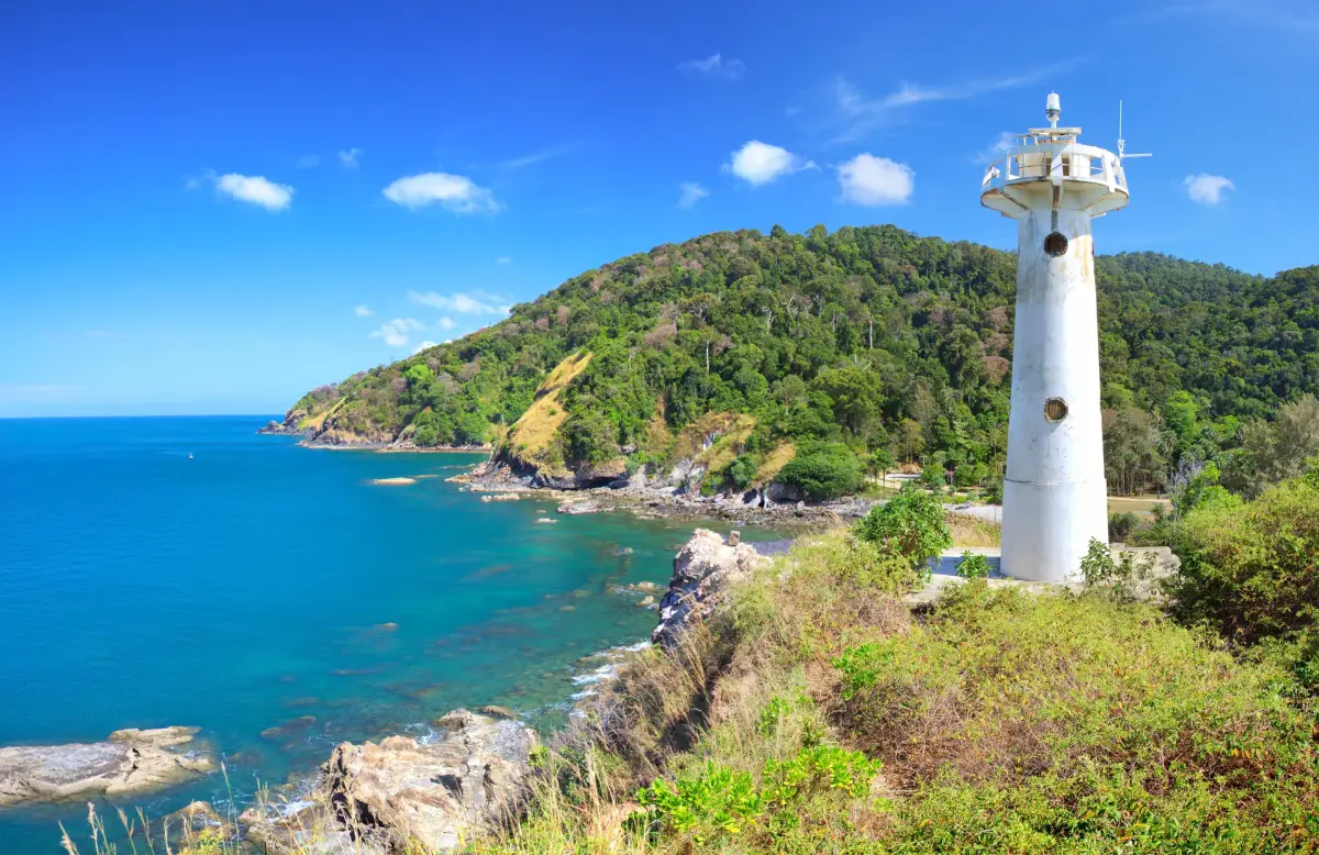
Laem Tanod is the best-known viewpoint in the park. The headland extends into the Andaman Sea, with a sandy beach on one side and a rocky shoreline on the other. A low hill leads up to the white lighthouse, where visitors can see the sea, the forested hills of Ko Lanta Yai, the curving beach below, and a small island near the tip of the cape. The view combines sea, forest, cliff, and sky in one frame, making this one of the most photographed places in the national park.
The Laem Tanod lighthouse is the landmark most closely associated with the park. Its white form stands above the coastal hill, symbolizing sea navigation and the long relationship between Koh Lanta and the Andaman Sea. Visitors should walk carefully around the viewpoint because some sections are sloped, rocky, or close to cliff edges. During rain or strong wind, the ground can be slippery and extra caution is necessary.
The beach area at Laem Tanod includes both sand and rock. The sandy side is suitable for walking, resting, and enjoying the view, while the rocky side is more suitable for photography than swimming. When sea conditions are calm and the park allows access, visitors can relax along the beach. However, all visitors should follow warning flags and park announcements. The area has previously been affected by marine safety warnings after Portuguese man-of-war were found during the monsoon period.
Short nature trails around the headquarters area allow visitors to see coastal forest, hillside vegetation, birds, butterflies, dusky leaf monkeys, crab-eating macaques, and other island wildlife. Visitors must not feed wildlife, carry exposed food near monkeys, or try to approach animals for photos. Wildlife in the park should remain wild and should not become dependent on human food.
For overnight visitors, the park has accommodation and camping areas depending on seasonal operation and availability. Staying near Laem Tanod allows travelers to experience the quieter atmosphere of the southern end of Ko Lanta Yai, walk near the beach in the morning, and enjoy the park before day visitors arrive. Accommodation and camping should be arranged in advance through the national park system or by contacting the park directly.
Beyond Ko Lanta Yai, the park is widely known for Ko Rok, consisting of Ko Rok Nok and Ko Rok Nai. Ko Rok is famous for clear water, white sand, coral reefs, and snorkeling in the open season. Many visitors reach Ko Rok on day-trip boats from Koh Lanta, while some stay overnight when the park allows it. The area is one of the classic marine highlights of Krabi and the southern Andaman Sea.
Ko Haa, also known as the Ko Haa group or Ko Tukonlima in Thai references, is another major marine attraction. It is known for rocky islands, clear water, snorkeling, scuba diving, and underwater scenery. Hin Daeng and Hin Muang are famous deep-water dive sites associated with the park and are best suited to experienced divers traveling with licensed dive operators. These offshore areas are highly seasonal and must be visited only when the sea is open and safe.
Ko Ngai is another island linked with Mu Ko Lanta National Park tourism. It is known for long sandy beaches, clear water, and coral areas that connect travel routes between Krabi and Trang. Like other offshore islands, visits depend strongly on weather, sea conditions, and national park announcements. The monsoon period from May to October is generally not suitable for remote island trips, and many offshore areas close seasonally for safety and natural recovery.
The park should therefore be understood in two main parts. The Laem Tanod headquarters area on Ko Lanta Yai is the road-accessible section that generally opens during normal daily hours when there is no temporary safety closure. The offshore islands and dive sites, such as Ko Rok, Ko Haa, Hin Daeng, and Hin Muang, are seasonal marine areas. Travelers should not assume that all park areas are open at the same time. A lighthouse visit and an offshore snorkeling trip require different planning.
In 2026, the park experienced both normal seasonal closures and temporary safety measures. In June 2026, the park temporarily closed Laem Tanod, Ko Haa, and Ko Ngai after Portuguese man-of-war were reported along affected beaches and marine areas. The park later announced the reopening of Laem Tanod, Ko Haa, and Ko Ngai from 13 June 2026 after conditions returned to normal. Even so, August remains within the monsoon season, so offshore trips should be planned only after checking current park notices and sea conditions.
Entrance fees for the main Laem Tanod area follow the national park fee structure: Thai adults 40 baht, Thai children 20 baht, foreign adults 200 baht, and foreign children 100 baht. Cars are charged 30 baht and motorcycles 20 baht. Special offshore areas such as Ko Rok, Ko Ngai, Ko Haa, and Hin Daeng-Hin Muang have special service rates for foreign visitors: 400 baht for adults and 200 baht for children. These fees do not include boat tours, diving services, transfers, accommodation, or private operator charges.
Getting There to Laem Tanod requires reaching Ko Lanta Yai first. From Krabi Town, travelers can go by private car, rental car, minivan, or transfer service toward Ban Hua Hin Pier, cross to Ko Lanta Noi, continue over the Siri Lanta Bridge to Ko Lanta Yai, and then drive south along the island road to Laem Tanod. From Sala Dan Pier to the park headquarters, the distance is about 30 kilometers and usually takes around 45 - 60 minutes depending on road and traffic conditions.
The road to the southern part of Ko Lanta is scenic but should be driven carefully. Some sections are hilly, winding, and steep. Motorcycle riders should have proper experience, wear helmets, and avoid riding in heavy rain. Travelers who are not confident driving on island roads should use a local taxi, transfer service, or car with driver.
Trips to Ko Rok, Ko Haa, Hin Daeng, and Hin Muang require boat services from licensed or responsible operators. Tour availability depends on the open marine season, sea conditions, and park regulations. Travelers should choose operators with proper safety equipment, life jackets, licensed guides or dive professionals, and clear environmental rules. Snorkelers and divers must not step on coral, touch marine animals, feed fish, or leave waste in the sea.
The best time to visit depends on the activity. Laem Tanod, the lighthouse, and the headquarters area can generally be visited whenever the park is open and weather conditions are safe. For Ko Rok, Ko Haa, Hin Daeng, Hin Muang, and other offshore sites, the best period is the open marine season, generally from November to mid-May. The monsoon season is more suitable for land-based Koh Lanta activities, old-town visits, community tourism, and viewpoints rather than remote island boat trips.
Mu Ko Lanta National Park suits many traveler types. Families can visit Laem Tanod, walk to the lighthouse, and enjoy the beach. Couples can take in the coastal views and photograph the landmark lighthouse. Photographers can capture headland scenery, rocky shores, forest, and late-afternoon light. Divers and snorkelers can plan seasonal trips to Ko Rok, Ko Haa, Hin Daeng, and Hin Muang. Cultural travelers can combine the park with Lanta Old Town, Ban Sangka U, and Ban Thung Yee Pheng for a fuller understanding of Koh Lanta.
Visitors should follow all park rules carefully. Do not feed monkeys or wildlife, do not collect shells or coral, do not touch marine life, do not use drones without permission, do not swim when red flags or warning signs are present, and do not walk outside marked trails. Sea conditions can change quickly in the monsoon season, so safety announcements from park staff must be followed immediately.
Mu Ko Lanta National Park also connects naturally with the wider story of Koh Lanta. The island includes Muslim communities, Lanta Old Town or Ban Si Raya, the Urak Lawoi sea-people village at Ban Sangka U, Ban Thung Yee Pheng mangrove community, and a series of western beaches. Together with Laem Tanod, Ko Rok, Ko Haa, and the offshore reefs, these places make Koh Lanta a destination that combines nature, sea, culture, history, and local life.
In summary, Mu Ko Lanta National Park in Krabi is a major marine national park that deserves careful planning. Laem Tanod is best for an accessible lighthouse, beach, viewpoint, and coastal forest experience. Ko Rok, Ko Haa, Ko Ngai, Hin Daeng, and Hin Muang are best for clear-water island trips, snorkeling, and diving during the open season. With responsible travel, respect for park rules, and up-to-date checks on closures and sea conditions, the park offers one of the most complete Andaman Sea experiences in Krabi Province.
| Name | Mu Ko Lanta National Park |
| Location | Ko Lanta District, Krabi Province; the park headquarters are located at Laem Tanod on the southern tip of Ko Lanta Yai |
| Address | Moo 5, Ban Laem Tanod, Ko Lanta Yai Subdistrict, Ko Lanta District, Krabi Province 81150 |
| Coordinates | Approximately 7.4699, 99.0982 around the headquarters and Laem Tanod area |
| Area | About 134 square kilometers, or approximately 83,750 rai |
| Highlights | Laem Tanod, white lighthouse, beaches, rocky shore, viewpoint, coastal forest, Ko Rok, Ko Haa, Ko Ngai, Hin Daeng, Hin Muang, coral reefs, snorkeling, and scuba diving |
| History / Park Status | A marine national park in Krabi Province, established on 15 August 1990 to protect islands, beaches, mangroves, coral reefs, and southern Andaman Sea ecosystems |
| Natural Characteristics | Main islands, satellite islands, beaches, cliffs, island forest, beach forest, mangroves, shallow coral reefs, deep dive sites, and marine conservation areas |
| Travel Information | From Krabi Town, travel to Ban Hua Hin vehicle ferry, cross to Ko Lanta Noi, continue over Siri Lanta Bridge to Ko Lanta Yai, then drive south to Laem Tanod. Ko Rok, Ko Haa, and offshore dive sites require seasonal boat tours |
| Approximate Distance | About 30 km from Sala Dan Pier to Laem Tanod / about 22 km from Lanta Old Town / about 80 - 90 km from Krabi Town to Ko Lanta Yai, depending on route |
| Current Status | The Laem Tanod headquarters area operates during normal opening hours when there is no temporary safety closure. Offshore areas such as Ko Rok, Ko Haa, Hin Daeng, and Hin Muang are seasonal and close during the monsoon period for safety and ecological recovery |
| Offshore Marine Season | Ko Rok, Ko Haa, Hin Daeng-Hin Muang, and remote marine areas generally open from around 1 November to 15 May and close during the monsoon period from around 16 May to 31 October |
| Open Days | Daily for the Laem Tanod headquarters area when there is no temporary closure notice |
| Opening Hours | 08.30 - 16.30 |
| Main Area Entrance Fee | Thai adults 40 baht, Thai children 20 baht / Foreign adults 200 baht, foreign children 100 baht / Car 30 baht / Motorcycle 20 baht |
| Special Offshore Service Fee | Ko Rok, Ko Ngai, Ko Haa, and Hin Daeng-Hin Muang have special rates for foreign visitors: adults 400 baht, children 200 baht, excluding boat tours, diving, or private operator services |
| Main Areas / Zones | Park headquarters, Laem Tanod, lighthouse, Tanod Beach, rocky shore, nature trail, campground, park accommodation, Ko Rok, Ko Haa, Ko Ngai, Ko Talabeng, Ko Mo, Hin Daeng, and Hin Muang |
| Facilities | Visitor center, toilets, parking area, welfare restaurant or shop, camping area, park accommodation, nature trail, viewpoint, and park staff on duty |
| Caretaker / Responsible Office | Department of National Parks, Wildlife and Plant Conservation / Mu Ko Lanta National Park |
| Main Contact Number | 075-656-576, 075-656-577 |
| Nearby Tourist Attractions | 1. Laem Tanod and Lighthouse, about 0 km 2. Ba Kan Tiang Bay, about 9 km 3. Bamboo Bay, about 3 km 4. Ban Sangka U, about 14 km 5. Lanta Old Town / Ban Si Raya, about 22 km 6. Ban Thung Yee Pheng, about 28 km |
| Nearby Restaurants | 1. National Park Welfare Restaurant, Laem Tanod area, about 0 km 2. View Point Restaurant, about 6 km, Tel. 081-787-8697 3. Same Same But Different, about 8 km 4. Noon Sunset View Point Restaurant, about 8 km 5. Alama Café & Restaurant, about 9 km, Tel. 075-665-151, 075-665-155 6. Rak Talay Beach Bar and Restaurant, about 9 km |
| Nearby Accommodations | 1. Mu Ko Lanta National Park Accommodation and Camping Area, about 0 km, Tel. 075-656-576, 075-656-577 2. LaLaanta Hideaway Resort, about 3 km 3. Anda Lanta Resort, about 4 km, Tel. 075-665-018 4. Pimalai Resort and Spa, about 8 km, Tel. 075-607-999 5. The Houben Hotel, about 9 km, Tel. 075-665-144, 082-800-3880 6. Alama Sea Village Resort, about 9 km, Tel. 075-665-151, 075-665-155 |
Frequently Asked Questions (FAQ)
Q: Where is Mu Ko Lanta National Park located?
A: It is located in Ko Lanta District, Krabi Province. The park headquarters are at Laem Tanod on the southern tip of Ko Lanta Yai.
Q: What is Mu Ko Lanta National Park known for?
A: It is known for Laem Tanod, the white lighthouse, beaches, rocky coastline, viewpoints, coastal forest, Ko Rok, Ko Haa, Ko Ngai, Hin Daeng, Hin Muang, coral reefs, snorkeling, and scuba diving.
Q: What are the opening hours?
A: The Laem Tanod headquarters area is open daily from 08.30 to 16.30 when there is no temporary closure notice. Offshore islands and dive sites operate seasonally.
Q: How much is the entrance fee?
A: The main area entrance fee is 40 baht for Thai adults, 20 baht for Thai children, 200 baht for foreign adults, and 100 baht for foreign children. Special offshore areas may have separate rates and boat tour costs.
Q: Are Ko Rok and Ko Haa open all year?
A: No. Ko Rok, Ko Haa, Hin Daeng-Hin Muang, and remote marine areas are seasonal. They generally open from around 1 November to 15 May and close during the monsoon period from around 16 May to 31 October.
Q: How can travelers get to Laem Tanod?
A: From Sala Dan or other areas on Ko Lanta Yai, drive south along the island road to Laem Tanod. The distance from Sala Dan Pier is about 30 km, and the road has hills and curves in the southern section.
Q: Is accommodation available inside the national park?
A: Park accommodation and camping are available in the Laem Tanod headquarters area according to seasonal operation and availability. Visitors should contact the park or use the national park reservation system before traveling.
Q: What should visitors be careful about?
A: Visitors should follow park warning flags and announcements, avoid feeding monkeys, avoid touching marine life, never step on coral, avoid swimming when red flags are present, and check weather and sea conditions before offshore trips.
 Category: ●Nature and Wildlife
 Group: ●National Parks and Marine Reserves
Last Update : 2 MonthAgo
 Last Update : 2 MonthAgo
 Click to Access the Navigation Map GPS
Mu Ko Lanta National Park Map
Gellery
Recommend

 Art, Culture and Heritage
 Historical Sites and Monuments(1)
 Landmarks and Memorials(7)
 Art, Craft Centres, Tradition(2)
 Museums(2)
 Educational Places
 Educational Gardens, Farm(1)
 Places of Worship
 Temple(3)
 Mosque(2)
 Other Sacred Sites(2)
 Research and Development
 Royal Project(1)
 Suburban Living
 Village, Community(6)
National Parks and Marine Reserves(5)
Village, Community(6)
National Parks and Marine Reserves(5)
 Mountain (Doi)(2)
 Dam, Reservoir, Lake(3)
 Waterfalls(12)
 Hot Springs(3)
 Caves(20)
 River, Canal(2)
 Bays and Beaches(36)
 Islands(23)
 Other natural attractions(7)
 Entertainment and Agricultural
 Farms, Parks and Ecotourism(1)
 Outdoor and Adventure Activities(1)
 Travel Articles, Recipes
 Travel Review, Food Review(2)
 Southern Food Menu, Southern Food Recipes(1)


